Zama City is a hamlet in northwestern Alberta, Canada within Mackenzie County.
Niton Junction is a hamlet in west-central Alberta, Canada within Yellowhead County. It is located on the Yellowhead Highway approximately 45 kilometres (28 mi) east of Edson and 150 kilometres (93 mi) west of Edmonton. It is east of the Yellowhead Highway's junction with Highway 32 and west of Chip Lake. Niton Junction has an elevation of 845 metres (2,772 ft).

Lac des Arcs is a hamlet in Alberta, Canada within the Municipal District (MD) of Bighorn No. 8. It is located on the south side of the Bow River opposite the Hamlet of Exshaw and has an elevation of 1,320 metres (4,330 ft). Highway 1 borders Lac des Arcs on the south.
Blue Ridge is a hamlet in northwest Alberta, Canada within Woodlands County. It is located on Highway 658, 7 kilometres (4.3 mi) north of Highway 43 and 3 kilometres (1.9 mi) south of the Athabasca River. It is midway between the towns of Whitecourt and Mayerthorpe and approximately 159 kilometres (99 mi) northwest of Edmonton.
Atmore is a hamlet in Alberta, Canada within Athabasca County. It is located 1 km (0.62 mi) east of the junction of Highway 55 and Highway 63, 43 km (27 mi) west of Lac La Biche, 54 km (34 mi) east of Athabasca and 250 km (160 mi) south of Fort McMurray.
Byemoor is a hamlet in Alberta, Canada within the County of Stettler No. 6. It is located at the intersection of Highway 853 and Highway 589, approximately 70 kilometres (43 mi) southeast of Stettler and 80 kilometres (50 mi) northeast of Drumheller. It has an elevation of 845 metres (2,772 ft).
Peers is a hamlet in west-central Alberta, Canada within Yellowhead County. It is located on Highway 32, 8 kilometres (5.0 mi) north of the Yellowhead Highway and approximately 35 kilometres (22 mi) northeast of Edson. January Creek, a tributary of the McLeod River flows directly adjacent to the hamlet. Peers is also home to the annual Peers Gold Dust Daze, which takes place ~3 miles away from Peers
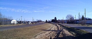
Marlboro is a hamlet in west-central Alberta, Canada within Yellowhead County. It is located on the Yellowhead Highway, approximately 25 kilometres (16 mi) west of Edson. Sundance Provincial Park is located northwest of the hamlet.
Bezanson is a hamlet in northern Alberta, Canada within the County of Grande Prairie No. 1. It is located approximately 30 kilometres (19 mi) east of Grande Prairie on Highway 43, west of the Smoky River.

Valhalla Centre is a hamlet in northern Alberta, Canada within the County of Grande Prairie No. 1.
La Glace is a hamlet in northern Alberta, Canada within the County of Grande Prairie No. 1. It is located along Highway 59 between Sexsmith and Valhalla Centre and has an elevation of 735 metres (2,411 ft).
Dixonville is a hamlet in Alberta, Canada within the County of Northern Lights. It is located along the Mackenzie Highway, approximately 43 kilometres (27 mi) north of Grimshaw. It has an elevation of 640 metres (2,100 ft).
Newbrook is a hamlet in central Alberta, Canada within Thorhild County. It is located at the junction of Highway 63 and Highway 661, approximately 28 kilometres (17 mi) northeast of Thorhild and 36 kilometres (22 mi) south of Boyle. It has an elevation of 665 metres (2,182 ft).
Busby is a small hamlet in central Alberta, Canada within Westlock County. It is located on Highway 651, approximately 52 kilometres (32 mi) northwest of Edmonton and 16 kilometres (9.9 mi) west of Highway 2.
Morningside is a hamlet in central Alberta, Canada within Lacombe County. It is located just east of Highway 2 at the intersection of Highway 2A and Highway 604, approximately 36 kilometres (22 mi) north of Red Deer.
Alder Flats is a hamlet in central Alberta, Canada within the County of Wetaskiwin No. 10. It is located 8 kilometres (5.0 mi) west of Highway 22 at the western terminus of Highway 13, approximately 120 kilometres (75 mi) southwest of Edmonton.
Beaver Lake is a hamlet in northern Alberta, Canada within Lac La Biche County. It is located on the shore of Beaver Lake, 4 kilometres (2.5 mi) east of Highway 36, approximately 116 kilometres (72 mi) northwest of Cold Lake.
Grassland is a hamlet in northern Alberta, Canada within Athabasca County. It is on Highway 63, 151 kilometres (94 mi) northeast of Edmonton.
Harvie Heights is a hamlet in Alberta, Canada, within the Municipal District of Bighorn No. 8. It is located within Alberta's Rockies on the Trans-Canada Highway approximately 4 kilometres (2.5 mi) northwest of Canmore and immediately east of the park gate for Banff National Park.
Lousana is a hamlet in central Alberta, Canada within Red Deer County. It is located 4 kilometres (2.5 mi) east of the junction of Highway 21 and Highway 42, approximately 45 kilometres (28 mi) southeast of Red Deer.
