Mackenzie County

Last updated
Mackenzie County
Mackenzie County, Alberta boundary sign.jpg
Welcome sign
AB Mackenzie County.png
AB locator MACKENZIE COUNTY.svg
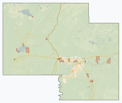
Location within Alberta
CountryCanada
Province Alberta
Region Northern Alberta
Planning region Lower Peace
Incorporated  [1]
 - Municipal district  

January 1, 1995
 - Specialized municipality June 23, 1999
Name change  [1] March 8, 2007
Government
[2]
   Reeve Josh Knelsen [3]
  Governing body
  • Jacquie Bateman
  • Peter F. Braun
  • Cameron Cardinal
  • David Driedger
  • Eric Jorgensen
  • Joshua Knelsen
  • Anthony Peters
  • Ernest Peters
  • Walter Sarapuk
  • Lisa Wardley
  CAOBryon Peters
   Administrative office Fort Vermilion
Area
 (2021) [4]
  Land79,629.26 km2 (30,745.03 sq mi)
Population
 (2021) [4]
  Total12,804
  Density0.2/km2 (0.5/sq mi)
   Municipal census (2018)
12,514
Time zone UTC−7 (MST)
  Summer (DST) UTC−6 (MDT)
Website mackenziecounty.com

Mackenzie County is a specialized municipality in northern Alberta, Canada. It is located in Census Division 17, along the Mackenzie Highway. The municipal office is located in the hamlet of Fort Vermilion.

Contents

History

Originally Improvement District No. 23, the Municipal District of Mackenzie No. 23 incorporated as a municipal district on January 1, 1995. [1] It subsequently changed its status to specialized municipality on June 23, 1999 "to address concerns about municipal government and management in a municipality that serves a number of unique communities within a very large territory." [1] The Municipal District of Mackenzie No. 23 changed its name to Mackenzie County on March 8, 2007. [1]

Geography

Peace River in Fort Vermilion FortVermilion-Sunset.JPG
Peace River in Fort Vermilion

Mackenzie County is in the northwest corner of the province of Alberta. [5] It borders the province of British Columbia to the west; the Northwest Territories to the north; Improvement District No. 24 (Wood Buffalo National Park) and the Regional Municipality of Wood Buffalo to the east; and Northern Sunrise County, the Paddle Prairie Metis Settlement, and the County of Northern Lights to the south. [5] The Peace River meanders eastward through the southeast portion of Mackenzie County. [5] Some of its water bodies include Bistcho Lake, Eva Lake, Margaret Lake, Wadlin Lake, Wentzel Lake, and Zama Lake. [5] Land formations include Bootis Hill in the northwest, the Caribou Mountains in the northeast, Buffalo Head Hills in the south, Cameron Hills in the north, and Mount Watt northwest of the Town of High Level. [5]

Communities and localities

The following localities are within Mackenzie County. [7]

Localities

The following settlements are within Mackenzie County. [5]

Settlements

First Nations have the following Indian reserves within Mackenzie County. [5]

Indian reserves

Demographics

Federal census
population history
YearPop.±%
19917,260    
1996 7,980+9.9%
2001 8,829+10.6%
2006 10,002+13.3%
2011 10,927+9.2%
2016 11,171+2.2%
2021 12,804+14.6%
Source: Statistics Canada [9] [10] [11] [12] [13] [4]

In the 2021 Census of Population conducted by Statistics Canada, Mackenzie County had a population of 12,804 living in 3,516 of its 3,756 total private dwellings, a change of

The population of Mackenzie County according to its 2018 municipal census is 12,514, [14] a change of

In the 2016 Census of Population conducted by Statistics Canada, Mackenzie County had a population of 11,171 living in 3,088 of its 3,567 total private dwellings, a change of

Attractions

Mackenzie County is home to Caribou Mountains Wildland Provincial Park and Hay-Zama Lakes Wildland Provincial Park. [5] It is also adjacent to Wood Buffalo National Park to the east. [5]

See also

Related Research Articles

<span class="mw-page-title-main">Regional Municipality of Wood Buffalo</span> Municipality in Alberta, Canada

The Regional Municipality of Wood Buffalo is a specialized municipality in northeast Alberta, Canada. It is the second largest municipality in Alberta by area and is home to oil sand deposits known as the Athabasca oil sands.

<span class="mw-page-title-main">Foothills County</span> Municipal district in Alberta, Canada

Foothills County is a municipal district in southern Alberta, Canada adjacent to the south side of Calgary in Census Division No. 6. Despite sharing a common border with the City of Calgary, it does not form part of the Calgary census metropolitan area (CMA) as defined by Statistics Canada. It is however a member municipality of the Calgary Metropolitan Region Board.

<span class="mw-page-title-main">County of Grande Prairie No. 1</span> Municipal district in Alberta, Canada

The County of Grande Prairie No. 1 is a municipal district in northwestern Alberta, Canada in Census Division No. 19.

<span class="mw-page-title-main">Clearwater County, Alberta</span> Municipal district in Alberta, Canada

Clearwater County is a municipal district in west central Alberta, Canada in Division No. 9. Its northwest boundary is the Brazeau River. The municipal office is located in the Town of Rocky Mountain House. The county has a land area of 18,691.65 km2 and comprises close to 99% of Census Division No. 9's land area of 18,921.38 km2. Although the territory excluded is rather small in geographical area, it comprises the major population centre of Rocky Mountain House, which has one-third of Division No. 9's population, in addition to the communities of Caroline, Burnstick Lake and three Indian reserves. The county's 2016 census population was 11,947.

<span class="mw-page-title-main">Municipal District of Bonnyville No. 87</span> Municipal district in Alberta, Canada

The Municipal District of Bonnyville No. 87 is a municipal district (MD) in northeastern Alberta, Canada in Division No. 12. On the east, it is adjacent to the province of Saskatchewan.

Zama City is a hamlet in northwestern Alberta, Canada within Mackenzie County.

<span class="mw-page-title-main">Division No. 17, Alberta</span> Census division in Alberta, Canada

Division No. 17 is a census division in Alberta, Canada. It spans the central and northwest portions of northern Alberta and its largest urban community is the Town of Slave Lake. Division No. 17 is the largest census division in Alberta according to area and also has the lowest population density.

<span class="mw-page-title-main">County of Vermilion River</span> Municipal district in Alberta, Canada

The County of Vermilion River is a municipal district located in the eastern part of central Alberta, Canada in Census Division No. 10. The municipal district was formerly named the County of Vermilion River No. 24 prior to an official name change that became effective on September 13, 2006.

<span class="mw-page-title-main">Rainbow Lake, Alberta</span> Town in Alberta, Canada

Rainbow Lake is a town in northwest Alberta, Canada. It is west of High Level at the end of Highway 58, in Mackenzie County.

<span class="mw-page-title-main">County of Barrhead No. 11</span> Municipal district in Alberta, Canada

The County of Barrhead No. 11 is a municipal district in north central Alberta, Canada. It is located northwest of Edmonton and is in Census Division No. 13.

<span class="mw-page-title-main">Lac La Biche County</span> Specialized municipality in Alberta, Canada

Lac La Biche County is a specialized municipality within Division No. 12 in northern Alberta, Canada. It was established through the amalgamation of the Town of Lac La Biche and Lakeland County in 2007.

<span class="mw-page-title-main">Beaver County, Alberta</span> Municipal district in Alberta, Canada

Beaver County is a municipal district in central-east Alberta, Canada. It is centred on Holden in the western part of Census Division No. 10. Its municipal office is located in Ryley.

<span class="mw-page-title-main">Big Lakes County</span> Municipal district in Alberta, Canada

Big Lakes County, formerly the Municipal District of Big Lakes, is a municipal district in north-central Alberta, Canada.

<span class="mw-page-title-main">Northern Sunrise County</span> Municipal district in Alberta, Canada

Northern Sunrise County is a municipal district in northern Alberta, Canada. Located in Census Division 17, its municipal office is located east of the Town of Peace River at the intersection of Highway 2 and Highway 688.

<span class="mw-page-title-main">Lacombe County</span> Municipal district in Alberta, Canada

Lacombe County is a municipal district in central Alberta, Canada. It is within in Census Division No. 8 north of the City of Red Deer. Its municipal office is 4 km (2.5 mi) west of Highway 2 and the City of Lacombe, and 6 km (3.7 mi) east of the Summer Village of Gull Lake, at the intersection of Highway 12 and Spruceville Road.

<span class="mw-page-title-main">County of Northern Lights</span> Municipal district in Alberta, Canada

The County of Northern Lights is a municipal district in northwest Alberta, Canada. Located in Census Division 17, its municipal office is located in the Town of Manning.

<span class="mw-page-title-main">Vulcan County</span> Municipal district in Alberta, Canada

Vulcan County is a municipal district in Alberta, Canada. Located in Census Division No. 5, its municipal office is located in the Town of Vulcan.

<span class="mw-page-title-main">Smoky Lake County</span> Municipal district in Alberta, Canada

Smoky Lake County is a municipal district in north-eastern Alberta, Canada. Located in Census Division No. 12, its municipal office is located in the Town of Smoky Lake.

<span class="mw-page-title-main">Improvement District No. 24</span> Improvement district in Alberta, Canada

Improvement District No. 24, or Improvement District No. 24 , is an improvement district in Alberta, Canada. Coextensive with the portion of Wood Buffalo National Park in northeast Alberta, the improvement district provides local governance for lands within the park that are not within Indian reserves.

References

  1. 1 2 3 4 5 "Location and History Profile – Mackenzie County" (PDF). Alberta Municipal Affairs. October 15, 2021. Retrieved October 17, 2021.
  2. "Municipal Officials Search". Alberta Municipal Affairs. May 9, 2019. Retrieved October 1, 2021.
  3. "Councillors". www.mackenziecounty.com. Retrieved 2019-06-14.
  4. 1 2 3 4 "Population and dwelling counts: Canada, provinces and territories, and census subdivisions (municipalities)". Statistics Canada. February 9, 2022. Retrieved February 9, 2022.
  5. 1 2 3 4 5 6 7 8 9 2021 Provincial Base Map: Municipalities (PDF) (Map). Alberta Environment and Parks. July 26, 2021. Retrieved October 17, 2021.
  6. 1 2 "Specialized and Rural Municipalities and Their Communities" (PDF). Alberta Municipal Affairs. January 12, 2022. Retrieved January 21, 2022.
  7. "Standard Geographical Classification (SGC) 2006, Economic Regions: 4817095 - Mackenzie No. 23, geographical codes and localities, 2006". Statistics Canada. 2010-03-05. Retrieved 2012-08-11.
  8. Geo-Administrative Areas (Hamlet, Locality and Townsite Culture Points) (Geodatabase layer) (Map). AltaLIS. October 26, 2020. Retrieved October 2, 2021.{{cite map}}: CS1 maint: date and year (link)
  9. "Table 10: Population and Dwelling Counts, for Census Divisions, Census Subdivisions (Municipalities) and Designated Places, 1991 and 1996 Censuses – 100% Data". 96 Census. Vol. A National Overview – Population and Dwelling Counts. Ottawa: Statistics Canada. 1997. pp. 136–146. ISBN   0-660-59283-5.
  10. "Population and Dwelling Counts, for Canada, Provinces and Territories, and Census Divisions, 2001 and 1996 Censuses - 100% Data (Alberta)". Statistics Canada . Retrieved 2013-02-16.
  11. "Population and dwelling counts, for Canada, provinces and territories, and census subdivisions (municipalities), 2006 and 2001 censuses - 100% data (Alberta)". Statistics Canada. 2010-01-06. Retrieved 2013-02-16.
  12. "Population and dwelling counts, for Canada, provinces and territories, and census subdivisions (municipalities), 2011 and 2006 censuses (Alberta)". Statistics Canada. February 8, 2012. Retrieved February 8, 2012.
  13. 1 2 "Population and dwelling counts, for Canada, provinces and territories, and census subdivisions (municipalities), 2016 and 2011 censuses – 100% data (Alberta)". Statistics Canada. February 8, 2017. Retrieved February 8, 2017.
  14. 2018 Municipal Affairs Population List (PDF). Alberta Municipal Affairs. December 2018. ISBN   978-1-4601-4254-7 . Retrieved December 20, 2018.
  15. "Request for Decision: 2015 Census Results" (PDF). Mackenzie County. August 26, 2015. Retrieved August 21, 2015.