
Forestburg is a village located in east-central Alberta, Canada. The rich farmland of the area was first settled in 1905. Soon after the first of many "gopher hole" mines, homesteaders were soon coal mining on the banks of the Battle River in 1907.
The Municipality of Crowsnest Pass is a specialized municipality in southwest Alberta, Canada. Within the Rocky Mountains adjacent to the eponymous Crowsnest Pass, the municipality formed as a result of the 1979 amalgamation of five municipalities – the Village of Bellevue, the Town of Blairmore, the Town of Coleman, the Village of Frank, and Improvement District No. 5, which included the Hamlet of Hillcrest and numerous other unincorporated communities.
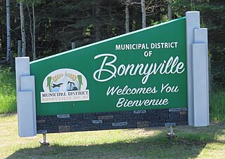
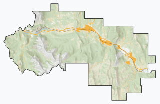
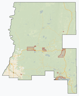
The Municipal District of Bonnyville No. 87 is a municipal district (MD) in northeastern Alberta, Canada in Division No. 12. On the east, it is adjacent to the province of Saskatchewan.

The Municipal District of Taber is a municipal district (MD) in southern Alberta, Canada. It is located in Census Division 2.
Kitscoty is a village located in central Alberta, Canada. Situated at the junction of Highway 16 and Highway 897, the village is located approximately midway between Edmonton and Saskatoon. In addition, the village is within short commuting distance of Lloydminster. The CN railway tracks also pass through Kitscoty. The municipal office of the surrounding County of Vermilion River's is located in Kitscoty.

Coalhurst is a town in southern Alberta, Canada. It is located on Highway 3, 15 km (9.3 mi) northwest of Lethbridge. It used to be a coal-mining community.

Two Hills is a town in central Alberta, Canada. It is approximately 137 km (85 mi) east of Edmonton at the junction of Highway 45 and Highway 36. Two Hills is primarily an agriculture-based community. It was named from the presence of two hills located near the town. Post office established in 1914.

Carmangay is a village in southern Alberta, Canada. It is located 62 kilometres (39 mi) north of Lethbridge and 150 kilometres (93 mi) south of Calgary, along the Canadian Pacific Railway, east of Highway 23. It takes its name from C.W. Carman, who bought 1,500 acres (6.1 km2) at $3.50 per acre to grow wheat in 1904, and his wife, Gertrude Gay.
Chauvin is a village in east central Alberta, Canada. It is located 60 kilometres (37 mi) east of Wainwright, and 10 kilometres (6.2 mi) west of the Saskatchewan border. It is also the home of Susie the Softball, the world's largest softball.
Thorsby is a town in central Alberta, Canada. It is approximately 38 km (24 mi) west of the Leduc on Highway 39. Pigeon Lake and Pigeon Lake Provincial Park are located 20 km (12 mi) south of the community.

The Municipal District of Acadia No. 34 is a municipal district (MD) in southern Alberta, Canada, east of Calgary, close to the Saskatchewan border, in Census Division No. 4.

Lac La Biche County is a specialized municipality within Division No. 12 in northern Alberta, Canada. It was established through the amalgamation of the Town of Lac La Biche and Lakeland County in 2007.
Northern Sunrise County is a municipal district in northern Alberta, Canada. Located in Census Division 17, its municipal office is located east of the Town of Peace River at the intersection of Highway 2 and Highway 688.

The Municipal District of Lesser Slave River No. 124 is a municipal district (MD) in north-central Alberta, Canada. Its municipal office is located in the Town of Slave Lake. Located in Census Division 17, the MD takes its name from Lesser Slave River, which drains Lesser Slave Lake into the Athabasca River.

Mackenzie County is a specialized municipality in northern Alberta, Canada. It is located in Census Division 17, along the Mackenzie Highway. Mackenzie County municipal office is located in the Hamlet of Fort Vermilion.

The Municipal District of Willow Creek No. 26 is a municipal district (MD) in southern Alberta, Canada. Located in Census Division No. 3, its municipal office is located adjacent to Claresholm Industrial Airport, west of the Town of Claresholm.

The County of St. Paul No. 19 is a municipal district in eastern central Alberta, Canada. Located in Census Division No. 12, its municipal office is located in the Town of St. Paul.
The Municipal District of Ranchland No. 66 is a municipal district (MD) in southwest Alberta, Canada. Containing no urban communities of any kind, its municipal office is located in Chain Lakes Provincial Park, approximately 38 km (24 mi) southwest of the Town of Nanton. Ranchland's rugged foothill terrain is unsuited for the crop agriculture practiced elsewhere in Alberta, and ranching remains the single livelihood of its inhabitants. With a 2016 population of 92, it is the least populated municipal district in Alberta, and its population density of 29 square kilometres for every resident is almost exactly equal to that of the Northwest Territories.
Point Alison is a summer village in Alberta, Canada. It is located on the northern shore of Wabamun Lake, and south of the Village of Wabamun.

Improvement District No. 4, or Improvement District No. 04 (Waterton), is an improvement district in Alberta, Canada. Coextensive with Waterton Lakes National Park in southern Alberta, the improvement district provides local governance for lands within the park that are not within an Indian reserve.


