Lac Ste. Anne County

Last updated

Lac Ste. Anne County
LSAC-new-logo.png
Major communities
AB locator LAC STE ANNE COUNTY.svg
Location within Alberta
CountryCanada
Province Alberta
Region Central Alberta
Planning region Upper Athabasca
Established1944
Incorporated1965
Government
[1]
  ReeveJoe Blakeman
  Governing bodyLac Ste. Anne County Council [2]


Joe Blakeman
Nick Gelych
Lorne Olsvik
George Vaughan
Steve Hoyda
Ross Bohnet
Lloyd Giebelhaus

Contents


  ManagerMike Primeau
   Administrative office Sangudo
Area
 (2021) [3]
  Land2,845.84 km2 (1,098.78 sq mi)
Population
 (2021) [3]
  Total10,832
  Density3.8/km2 (10/sq mi)
Time zone UTC−07:00 (MST)
  Summer (DST) UTC−06:00 (MDT)
Website lsac.ca

Lac Ste. Anne County is a municipal district in central Alberta, Canada.

It is located in Census Division 13, north west of Edmonton. Highway 43 stretches across this county. Its municipal office is located in the Hamlet of Sangudo.

The county was named after Lac Ste. Anne, which in turn was named for Saint Anne.

Geography

Communities and localities

The following localities are located within Lac Ste. Anne County. [5]

Localities

Demographics

In the 2021 Census of Population conducted by Statistics Canada, Lac Ste. Anne County had a population of 10,832 living in 4,373 of its 5,566 total private dwellings, a change of

In the 2016 Census of Population conducted by Statistics Canada, Lac Ste. Anne County had a population of 10,899 living in 4,346 of its 5,385 total private dwellings, a

Attractions

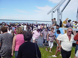
Lac Ste. Anne Pilgrimage Lac ste anne pilgrimage.jpg
Lac Ste. Anne Pilgrimage

The municipality of Lac Ste. Anne maintains the Lessard Lake Campground, the Lessard Lake Outdoor Ed Centre, the Riverside Campground, and the Paddle River Dam Campground.

Many summer villages are established, especially on lake shores (such as Lac Ste. Anne, Lac la Nonne, Nakamun Lake, and Lake Isle).

Protected and recreational areas in the county include Lily Lake Provincial Natural Area, Pembina River Provincial Natural Area, Majeau Lake Provincial Natural Area (with two campgrounds), Paddle River Dam Picnic Site, Park Court Provincial Natural Area, Lily Lake Provincial Natural Area and Prefontaine and Brock Lake Provincial Natural Area.

See also

Related Research Articles

Regional Municipality of Wood Buffalo Municipality in Alberta, Canada

The Regional Municipality of Wood Buffalo is a specialized municipality in northeast Alberta, Canada. It is the second largest municipality in Alberta by area and is home to oil sand deposits known as the Athabasca oil sands.

Parkland County Municipal district in Alberta, Canada

Parkland County is a municipal district in central Alberta, Canada. Located west of Edmonton in Census Division No. 11, its municipal office, Parkland County Centre, is located 0.25 km (0.16 mi) north of the Town of Stony Plain on Highway 779.

Wabamun, Alberta Hamlet in Alberta, Canada

Wabamun is a hamlet in central Alberta, Canada within Parkland County. It is approximately 67 kilometres (42 mi) west of Edmonton on Highway 16. It held village status prior to 2021.

Division No. 13, Alberta Census division in Alberta, Canada

Division No. 13 is a census division in Alberta, Canada. The majority of the division is located in the north-central portion of central Alberta, while the northeast portion of the division is located within northern Alberta. The division's largest urban community is the Town of Whitecourt.

County of Vermilion River Municipal district in Alberta, Canada

The County of Vermilion River is a municipal district located in the eastern part of central Alberta, Canada in Census Division No. 10. The municipal district was formerly named the County of Vermilion River No. 24 prior to an official name change that became effective on September 13, 2006.

Alberta Beach Village in Alberta, Canada

Alberta Beach is a village in central Alberta, Canada, west of Edmonton. It is located on the southeast shore of Lac Ste. Anne, approximately 8 km (5.0 mi) west of Highway 43 and 2 km (1.2 mi) north of Highway 633.

Sangudo Hamlet in Alberta, Canada

Sangudo is a hamlet in Alberta, Canada within Lac Ste. Anne County. It is located on Highway 43 and the Pembina River, approximately 99 kilometres (62 mi) northwest of Edmonton.

County of Barrhead No. 11 Municipal district in Alberta, Canada

The County of Barrhead No. 11 is a municipal district in north central Alberta, Canada. It is located northwest of Edmonton and is in Census Division No. 13.

Lac des Arcs, Alberta Hamlet in Alberta, Canada

Lac des Arcs is a hamlet in Alberta, Canada within the Municipal District (MD) of Bighorn No. 8. It is located on the south side of the Bow River opposite the Hamlet of Exshaw and has an elevation of 1,320 metres (4,330 ft). Highway 1 borders Lac des Arcs on the south.

Lac La Biche County Specialized municipality in Alberta, Canada

Lac La Biche County is a specialized municipality within Division No. 12 in northern Alberta, Canada. It was established through the amalgamation of the Town of Lac La Biche and Lakeland County in 2007.

Wildwood, Alberta Hamlet in Alberta, Canada

Wildwood is a hamlet in west-central Alberta, Canada within Yellowhead County. It is located on the Yellowhead Highway, approximately 112 kilometres (70 mi) west of Edmonton and 82 kilometres (51 mi) east of Edson. The Yellowhead Highway's intersection with Cowboy Trail is 9 kilometres (5.6 mi) east of the hamlet. The Lobstick River, which flows from Chip Lake to the west, runs through the hamlet.

Ross Haven is a summer village in Alberta, Canada. It is located on the northern shore of Lac Ste. Anne, south of Highway 43.

Sunset Point is a summer village in Alberta, Canada. It is located on the eastern shore of Lac Ste. Anne and north of Alberta Beach.

West Cove is a summer village in Alberta, Canada. It is located on the southern shore of Lac Ste. Anne.

Yellowstone is a summer village in Alberta, Canada. It is developed on the northern shore of Lac Ste. Anne, south of Alberta Highway 43, between Ross Haven and Gunn, 78 kilometres (48 mi) from Edmonton.

Castle Island is a summer village in Alberta, Canada. It is located on a small island on Lac Ste. Anne, close to the mouth of the Sturgeon River.

Cherhill, Alberta Hamlet in Alberta, Canada

Cherhill is a hamlet in Alberta, Canada within Lac Ste. Anne County. It is located along Highway 43, approximately 35 kilometres (22 mi) east of Mayerthorpe and 82 kilometres (51 mi) northwest of Edmonton.

Gunn is a hamlet in Alberta, Canada within Lac Ste. Anne County. It is located west of the junction of Highway 43 and Highway 33 on the northeast shore of Lac Ste. Anne. It is approximately 58 kilometres (36 mi) northwest of Edmonton and has an elevation of 740 metres (2,430 ft).

Beaver Lake is a hamlet in northern Alberta, Canada within Lac La Biche County. It is located on the shore of Beaver Lake, 4 kilometres (2.5 mi) east of Highway 36, approximately 116 kilometres (72 mi) northwest of Cold Lake.

References

  1. "Municipal Officials Search". Alberta Municipal Affairs. May 9, 2019. Retrieved October 1, 2021.
  2. "LSA - Reeve & Councillors". Archived from the original on February 24, 2020. Retrieved February 24, 2020.
  3. 1 2 3 "Population and dwelling counts: Canada, provinces and territories, and census subdivisions (municipalities)". Statistics Canada. February 9, 2022. Retrieved February 9, 2022.
  4. 1 2 "Specialized and Rural Municipalities and Their Communities" (PDF). Alberta Municipal Affairs. January 12, 2022. Retrieved January 21, 2022.
  5. "Standard Geographical Classification (SGC) 2006, Economic Regions: 4813001 - Lac Ste. Anne County, geographical codes and localities, 2006". Statistics Canada. March 5, 2010. Archived from the original on May 18, 2015. Retrieved August 11, 2012.
  6. "Population and dwelling counts, for Canada, provinces and territories, and census subdivisions (municipalities), 2016 and 2011 censuses – 100% data (Alberta)". Statistics Canada. February 8, 2017. Retrieved February 8, 2017.

Coordinates: 53°53′42″N114°53′27″W / 53.89500°N 114.89083°W / 53.89500; -114.89083