Flagstaff County

Last updated

Flagstaff County
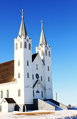
St. Peter's Roman Catholic Church.JPG
St. Peter's Roman Catholic Church
Flagstaff County, Alberta Logo.svg
Major communities
AB locator FLAGSTAFF COUNTY.svg
Location within Alberta
Coordinates: 52°46′21″N111°41′49″W / 52.77250°N 111.69694°W / 52.77250; -111.69694
CountryCanada
Province Alberta
Region Central Alberta
Planning region North Saskatchewan
Established1944
Incorporated1968
Government
[1]
   Reeve Donald Kroetch
  Governing bodyFlagstaff County Council
   Administrative office Sedgewick
Area
 (2021) [2]
  Land3,959.78 km2 (1,528.88 sq mi)
Population
 (2021) [2]
  Total3,694
  Density0.9/km2 (2/sq mi)
Time zone UTC−7 (MST)
  Summer (DST) UTC−6 (MDT)
Website flagstaff.ab.ca

Flagstaff County is a municipal district in east central Alberta, Canada.

Contents

It is located in Census Division 7. The county was incorporated in the current boundaries in 1944 as Municipal District of Killam No. 390, name changed a year later to Municipal District of Flagstaff No. 62. It was established as a county in 1968. Its municipal office is located in the Town of Sedgewick.

Geography

Communities and localities

Demographics

In the 2021 Census of Population conducted by Statistics Canada, Flagstaff County had a population of 3,694 living in 1,378 of its 1,558 total private dwellings, a change of

In the 2016 Census of Population conducted by Statistics Canada, Flagstaff County had a population of 3,738 living in 1,380 of its 1,532 total private dwellings, a

Infrastructure

Transportation

The area is served by Killam-Sedgewick/Flagstaff Regional Airport.

See also

Related Research Articles

<span class="mw-page-title-main">Foothills County</span> Municipal district in Alberta, Canada

Foothills County is a municipal district in southern Alberta, Canada adjacent to the south side of Calgary in Census Division No. 6. Despite sharing a common border with the City of Calgary, it does not form part of the Calgary census metropolitan area (CMA) as defined by Statistics Canada. It is however a member municipality of the Calgary Metropolitan Region Board.

<span class="mw-page-title-main">Athabasca County</span> Municipal district in Alberta, Canada

Athabasca County is a municipal district in north central Alberta, Canada. It is located northeast of Edmonton and is in Census Division No. 13. Prior to an official renaming on December 1, 2009, Athabasca County was officially known as the County of Athabasca No. 12.

<span class="mw-page-title-main">County of Stettler No. 6</span> Municipal district in Alberta, Canada

The County of Stettler No. 6 is a municipal district in central Alberta, Canada.

<span class="mw-page-title-main">Division No. 7, Alberta</span> Census division in Alberta, Canada

Division No. 7 is a census division in Alberta, Canada. It is located in the southeast corner of central Alberta and its largest urban community is the Town of Wainwright.

<span class="mw-page-title-main">Killam, Alberta</span> Town in Alberta, Canada

Killam is a town in central Alberta, Canada. It is located in Flagstaff County, east of Camrose at the junction of Highway 13 and Veterans Memorial Highway, Highway 36. Killam is located in a rich agricultural area and is a local hub for trade. It is considered the agricultural hub of Flagstaff County.

Sedgewick is a town in central Alberta, Canada. It is approximately 83 km (52 mi) east of Camrose at the junction of Highway 13 and Highway 869. The Canadian Pacific Kansas City railway runs through the town.

Botha is a hamlet in central Alberta, Canada within the County of Stettler No. 6. It is located approximately 88 km (55 mi) east of Red Deer and 13 km (8.1 mi) east of Stettler.

<span class="mw-page-title-main">Dewberry, Alberta</span> Hamlet in Alberta, Canada

Dewberry is a hamlet in central Alberta, Canada within the County of Vermilion River. It is approximately 66 km (41 mi) northwest of Lloydminster. The hamlet was named for the dewberries growing near the community. Its first school opened in 1930. Dewberry held village status prior to 2021.

Galahad is a hamlet in east-central Alberta, Canada within Flagstaff County. It is located just a few miles north of the Battle River valley on a former Canadian National rail line. The hamlet was originally incorporated as a village on May 5, 1918. It dissolved to become a hamlet under the jurisdiction of Flagstaff County on January 1, 2016.

Strome is a hamlet in east-central Alberta, Canada, within Flagstaff County. It is located on Highway 13, approximately 58 km (36 mi) east of the City of Camrose. The hamlet was originally incorporated as a village on February 3, 1910. It dissolved to become a hamlet under the jurisdiction of Flagstaff County on January 1, 2016. Strome's name is believed to come from Stromeferry in Ross & Cromarty, Scotland.

<span class="mw-page-title-main">Thorhild County</span> Municipal district in Alberta, Canada

Thorhild County is a municipal district located in the central part of northern Alberta, Canada, in Census Division 13. It was incorporated in 1955. It changed its name from the County of Thorhild No. 7 to Thorhild County on March 20, 2013.

<span class="mw-page-title-main">Lethbridge County</span> Municipal district in Alberta, Canada

Lethbridge County is a municipal district in southern Alberta, Canada. It is in Census Division No. 2 and part of the Lethbridge census agglomeration. It was known as the County of Lethbridge prior to December 4, 2013. Its name was changed in time for 2014 to coincide with its 50th anniversary.

<span class="mw-page-title-main">Big Lakes County</span> Municipal district in Alberta, Canada

Big Lakes County, formerly the Municipal District of Big Lakes, is a municipal district in north-central Alberta, Canada.

<span class="mw-page-title-main">Camrose County</span> Municipal district in Alberta, Canada

Camrose County is a municipal district in central Alberta, Canada. It is located in Census Division 10, around the City of Camrose.

<span class="mw-page-title-main">Lac Ste. Anne County</span> Municipal district in Alberta, Canada

Lac Ste. Anne County is a municipal district in central Alberta, Canada.

<span class="mw-page-title-main">County of Minburn No. 27</span> Municipal district in Alberta, Canada

The County of Minburn No. 27 is a municipal district in east central Alberta, Canada. Its municipal office is located in the Town of Vegreville. Located in Census Division No. 10, the County of Minburn No. 27 was formed as a county on January 1, 1965, from the former Municipal District of Minburn No. 72.

<span class="mw-page-title-main">County of Newell</span> Municipal district in Alberta, Canada

The County of Newell is a municipal district in southern Alberta, Canada. Located in Census Division No. 2, its municipal office is located south of the City of Brooks.

<span class="mw-page-title-main">Vulcan County</span> Municipal district in Alberta, Canada

Vulcan County is a municipal district in Alberta, Canada. Located in Census Division No. 5, its municipal office is located in the Town of Vulcan.

<span class="mw-page-title-main">County of Two Hills No. 21</span> Municipal district in Alberta, Canada

The County of Two Hills No. 21 is a municipal district in east-central Alberta, Canada. Located in Census Division No. 10, its municipal office is located in the Town of Two Hills.

<span class="mw-page-title-main">County of Paintearth No. 18</span> Municipal district in Alberta, Canada

The County of Paintearth No. 18 is a municipal district in east central Alberta, Canada. Located in Census Division No. 7, its municipal office is located southeast of the Town of Castor near the intersection of Highway 12 and Highway 36.

References

  1. "Municipal Officials Search". Alberta Municipal Affairs. May 9, 2019. Retrieved October 1, 2021.
  2. 1 2 3 "Population and dwelling counts: Canada, provinces and territories, and census subdivisions (municipalities)". Statistics Canada. February 9, 2022. Retrieved February 9, 2022.
  3. 1 2 "Specialized and Rural Municipalities and Their Communities" (PDF). Alberta Municipal Affairs. January 12, 2022. Retrieved January 21, 2022.
  4. "O.C. 259/2015". Government of Alberta. November 17, 2015. Retrieved November 19, 2015.
  5. "O.C. 260/2015". Government of Alberta. November 17, 2015. Retrieved November 19, 2015.
  6. "Standard Geographical Classification (SGC) 2006, Economic Regions: 4807031 - Flagstaff County, geographical codes and localities, 2006". Statistics Canada. March 5, 2010. Retrieved February 11, 2012.
  7. "Population and dwelling counts, for Canada, provinces and territories, and census subdivisions (municipalities), 2016 and 2011 censuses – 100% data (Alberta)". Statistics Canada. February 8, 2017. Retrieved February 8, 2017.