Warner No. 5 | |
|---|---|
| County of Warner No. 5 | |
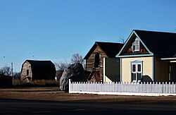
 Last surviving elevator row in Alberta, located in Warner | |
Logo | |
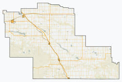
 Location within Alberta | |
| Country | Canada |
| Province | Alberta |
| Region | Southern Alberta |
| Planning region | South Saskatchewan |
| Established | 1912 |
| Incorporated | 1950 |
| Government | |
| • Reeve | Randy Taylor |
| • Governing body | County of Warner Council |
| • Administrative office | Warner |
| Area (2021) [2] | |
| • Land | 4,462.2 km2 (1,722.9 sq mi) |
| Population (2021) [2] | |
• Total | 4,290 |
| • Density | 1/km2 (2.6/sq mi) |
| Time zone | UTC−7 (MST) |
| • Summer (DST) | UTC−6 (MDT) |
| Website | warnercounty.ca |
The County of Warner No. 5 is a municipal district in southern Alberta, Canada. Located in Census Division No. 2 just north of the United States border, its municipal office is located in the Village of Warner.