List of hamlets in Alberta

Last updated

Distribution of Alberta's 403 hamlets by latest population available Alberta Hamlets.png
Distribution of Alberta's 403 hamlets by latest population available

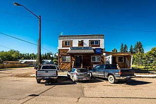
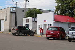
Hamlets in the Canadian province of Alberta are unincorporated communities administered by, and within the boundaries of, specialized municipalities or rural municipalities (municipal districts, improvement districts and special areas). They consist of five or more dwellings (a majority of which are on parcels of land that are smaller than 1,850 m2), have a generally accepted boundary and name, and contain parcels of land used for non-residential purposes. [1] [2]

Contents

Section 59 of the Municipal Government Act (MGA) enables specialized municipalities and municipal districts to designate a hamlet, while Section 590 of the MGA enables the Minister of Alberta Municipal Affairs to designate a hamlet within an improvement district. [1] The Minister may also designate a hamlet within a special area pursuant to Section 10 of the Special Areas Act. [3]

A hamlet can be incorporated as a village when its population reaches 300. However, Alberta has not had a hamlet incorporate as a village since January 1, 1980, when both Barnwell and Wabamun incorporated as villages. [4] [5] Since then, it has been more common for urban municipalities to dissolve from their current municipal status to that of a hamlet under the jurisdiction of its surrounding specialized or rural municipality. As such, the number of hamlets in Alberta has steadily grown over the years.
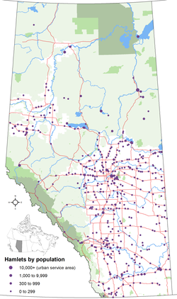
As of 2021, Alberta has 403 hamlets recognized by Alberta Municipal Affairs. [6]
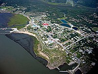
 Alberta's two largest hamlets – Fort McMurray (formerly a city) within the Regional Municipality of Wood Buffalo and Sherwood Park within Strathcona County – have been further designated as urban service areas by Municipal Affairs. If they were to incorporate as cities, Fort McMurray and Sherwood Park would rank fifth and sixth respectively among Alberta's largest cities by population. Alberta's newest hamlet is Hythe, whose village government dissolved on July 1, 2021, to become a hamlet under the jurisdiction of the County of Grande Prairie No. 1. [7]

The latest populations of hamlets are not published by Municipal Affairs, with the exception of the two urban service areas. [8]

List of hamlets

Entwistle Mainstreetentwistle.jpg
Entwistle
Exshaw townsite with plant Exshaw 031.jpg
Exshaw townsite with plant
Fort Chipewyan Fort Chipewyan aerial.jpg
Fort Chipewyan
Fort Vermilion FortVermilion-Aerial.JPG
Fort Vermilion
Neerlandia Neerlandia Downtown 2007.jpg
Neerlandia
New Dayton New Dayton School in Alberta.jpg
New Dayton
Orion OrionAlberta.jpg
Orion
Rosebud 2003-07-19 Rosebud Grain Elevators, Alberta CAN.jpg
Rosebud
Skiff Grain elevator in Skiff Alberta.jpg
Skiff
Valhalla Centre Vallhala Centre.JPG
Valhalla Centre

Notes:

  1. Bellis dissolved from village status on December 31, 1945.
  2. Blackie dissolved from village status on August 31, 1997.
  3. Burdett dissolved from village status on January 1, 2003.
  4. Cadogan dissolved from village status on December 31, 1945.
  5. Cayley dissolved from village status on June 1, 1996.
  6. Chinook dissolved from village status on April 1, 1977.
  7. Clairmont dissolved from village status on December 31, 1945.
  8. Cluny dissolved from village status on September 15, 1995.
  9. Compeer dissolved from village status on December 31, 1936.
  10. Craigmyle dissolved from village status on January 1, 1972.
  11. Cynthia dissolved from town status on May 1, 1959.
  12. Derwent dissolved from village status on September 1, 2010. [23]
  13. Diamond City dissolved from village status on June 30, 1937.
  14. Dunmore dissolved from village status on February 4, 1919.
  15. Eaglesham dissolved from village status on December 31, 1996.
  16. Enchant dissolved from village status on January 30, 1945.
  17. Entwistle dissolved from village status on December 31, 2000.
  18. Erskine dissolved from village status on May 20, 1946.
  19. Evansburg dissolved from village status on June 30, 1998.
  20. Ferintosh dissolved from village status on January 1, 2020.
  21. For Assiniboine dissolved from village status on December 31, 1991.
  22. Fort McKay's population does not include portion of community on Indian reserve.
  23. Fort McMurray is one of two hamlets designated an urban service area.
  24. Fort McMurray's population is that of its population centre as delineated by Statistics Canada. [29]
  25. Galahad dissolved from village status on January 1, 2016. [30]
  26. Gleichen dissolved from town status on March 31, 1998.
  27. Goose Lake is also known as Lone Pine.
  28. Grande Cache dissolved from town status on January 1, 2019. [33]
  29. Grassy Lake dissolved from village status on July 1, 1996.
  30. Grouard, also known as Grouard Mission, dissolved from village status on January 18, 1944.
  31. Hairy Hill dissolved from village status on December 31, 1996.
  32. Hairy Hill's population is from the 2001 federal census (Statistics Canada did not publish its population in the 2006, 2011 or 2016 federal censuses).
  33. Half Moon Lake is also known as Half Moon Estates.
  34. Heritage Pointe's population is that of its population centre as delineated by Statistics Canada. [29]
  35. Irvine dissolved from town status on December 31, 1996.
  36. Islay dissolved from village status on March 2, 1944.
  37. Janvier South is also known as Janvier and Chard.
  38. Jenner dissolved from village status on June 22, 1943.
  39. Kinuso dissolved from village status on September 1, 2009.
  40. Lac La Biche dissolved from town status on August 1, 2007, as a result of its amalgamation with Lakeland County to form Lac La Biche County. [39]
  41. Langdon dissolved from village status on December 31, 1945.
  42. Lavoy dissolved from village status on April 30, 1999.
  43. Lodgepole dissolved from new town status on March 1, 1970.
  44. Referred to as Lottie Lake Development by Statistics Canada in the 1991 census. [13]
  45. Statistics Canada cautioned that Metiskow's population from the 1991 census may be an estimate. [13]
  46. Minburn dissolved from village status on July 1, 2015. [45]
  47. Mirror dissolved from village status on January 1, 2004.
  48. Monarch dissolved from village status on December 31, 1938.
  49. Monitor dissolved from village status on December 31, 1945.
  50. Mountain View dissolved from village status on September 9, 1915.
  51. Mulhurst Bay is also known as Mulhurst.
  52. New Norway dissolved from village status on November 1, 2012. [47]
  53. New Sarepta dissolved from village status on September 1, 2010. [48]
  54. Ohaton dissolved from village status on December 31, 1945.
  55. Plamondon dissolved from village status on May 1, 2002.
  56. Radway dissolved from village status on December 31, 1996.
  57. Ranfurly dissolved from village status on December 31, 1945.
  58. Richdale dissolved from village status on June 2, 1931.
  59. Rosebud dissolved from village status on December 31, 1945.
  60. Rumsey dissolved from village status on January 1, 1995.
  61. Sandy Lake is also known as Pelican Mountain.
  62. Sangudo dissolved from village status on September 16, 2007.
  63. Sherwood Park is one of two hamlets designated an urban service area.
  64. Strome dissolved from village status on January 1, 2016. [53]
  65. Suffield dissolved from village status on January 1, 1930.
  66. Swalwell dissolved from village status on December 31, 1945.
  67. Thorhild dissolved from village status on March 18, 2009.
  68. Tilley dissolved from village status on August 31, 2013. [54]
  69. Torrington dissolved from village status on January 1, 1998.
  70. Wabasca was formerly named Wabasca-Desmarais.
  71. Statistics Canada cautioned that Wagner's population from the 1991 census may be an estimate. [13]
  72. Walsh dissolved from village status on April 30, 1925.
  73. Wanham dissolved from village status on December 31, 1999.
  74. Warspite dissolved from village status on June 1, 2000.
  75. Wildwood dissolved from village status on December 31, 1990.

Former hamlets

Numerous communities in Alberta have been previously recognized as hamlets by the Province of Alberta. The following are those hamlets that have been absorbed by urban municipalities through annexation or amalgamation.

NameFormer municipalitySubsequent municipalityRemarks
Bankview MD of Badlands No. 7 Drumheller Annexed in 1964 [57]
Cambria MD of Badlands No. 7 Drumheller Absorbed as a result of amalgamation January 1, 1998 [57] [58]
College Heights Lacombe County Lacombe Annexed January 1, 2000 [59] [60]
East Coulee MD of Badlands No. 7 Drumheller Absorbed as a result of amalgamation January 1, 1998 [57] [58]
Glenwood Yellowhead County Edson Annexed January 1, 1984 [61] [62]
Grande Prairie Trail Yellowhead County Edson Annexed January 1, 1984 [61] [62]
Grantville Kneehill County Three Hills Annexed January 1, 1983 [63] [64]
Hardieville Lethbridge County Lethbridge Annexed January 1, 1978 [65]
Hillcrest [66] [67] Improvement District No. 5 Municipality of Crowsnest Pass Absorbed via amalgamation January 1, 1979 [68]
Lehigh MD of Badlands No. 7 Drumheller Absorbed as a result of amalgamation January 1, 1998 [57] [58]
Midlandvale MD of Badlands No. 7 Drumheller Annexed in 1972 [57]
Midnapore MD of Foothills No. 31 Calgary Annexed in 1961 [69]
Nacmine MD of Badlands No. 7 Drumheller Absorbed as a result of amalgamation January 1, 1998 [57] [58]
Newcastle MD of Badlands No. 7 Drumheller Annexed in 1967 [57]
North Drumheller MD of Badlands No. 7 Drumheller Annexed in 1967 [57]
Rosedale MD of Badlands No. 7 Drumheller Absorbed as a result of amalgamation January 1, 1998 [57] [58]
Ruarkville Kneehill County Three Hills Annexed December 31, 1984 [70] [71]
Shepard Rocky View County Calgary Annexed July 31, 2007 [72] [73]
Wayne MD of Badlands No. 7 Drumheller Absorbed as a result of amalgamation January 1, 1998 [57] [58]
Western Monarch (Atlas) [74] Wheatland County MD of Badlands No. 7 [74] [75] Now within the Town of Drumheller following the amalgamation of the City
of Drumheller and the MD of Badlands No. 7 on January 1, 1998 [76]

See also

Related Research Articles

<span class="mw-page-title-main">Edmonton Metropolitan Region</span> Metropolitan area in Canada, Alberta

The Edmonton Metropolitan Region (EMR), also commonly referred to as Greater Edmonton or Metro Edmonton, is a conglomeration of municipalities centred on Alberta's provincial capital of Edmonton.

<span class="mw-page-title-main">Cereal, Alberta</span> Hamlet in Alberta, Canada

Cereal is a hamlet within Special Area No. 3 in central Alberta, Canada. It is approximately 161 km (100 mi) east of Drumheller. It was named after the post office that was established in the area in 1910. The name of the post office alluded to grain fields near the community. Cereal held village status prior to 2021.

<span class="mw-page-title-main">Dewberry, Alberta</span> Hamlet in Alberta, Canada

Dewberry is a hamlet in central Alberta, Canada within the County of Vermilion River. It is approximately 66 km (41 mi) northwest of Lloydminster. The hamlet was named for the dewberries growing near the community. Its first school opened in 1930. Dewberry held village status prior to 2021.

Minburn is a hamlet in central, Alberta, Canada within the County of Minburn No. 27. It is located on the Yellowhead Highway and the Canadian National Railway, approximately 37 km (23 mi) west of the Town of Vermilion and 143 km (89 mi) east of the City of Edmonton.

<span class="mw-page-title-main">New Sarepta</span> Hamlet in Alberta, Canada

New Sarepta is a hamlet in central Alberta, Canada, within Leduc County. It is located approximately 23 km (14 mi) east of the City of Leduc along Highway 21.

<span class="mw-page-title-main">Sangudo</span> Hamlet in Alberta, Canada

Sangudo is a hamlet in Alberta, Canada within Lac Ste. Anne County. It is located on Highway 43 and the Pembina River, approximately 99 kilometres (62 mi) northwest of Edmonton.

Thorhild is a hamlet in Alberta, Canada within Thorhild County. It is located at the intersection of Highway 18 and Highway 827, approximately 86 kilometres (53 mi) north-by-east of the City of Edmonton.

Burdett is a hamlet in Alberta, Canada within the County of Forty Mile No. 8. It is located approximately 71 km (44 mi) west of Medicine Hat and 97 km (60 mi) east of Lethbridge on Highway 3. Also, Burdett is regarded as the site of Canada's first irrigation pivot.

<span class="mw-page-title-main">Blackie, Alberta</span> Hamlet in Alberta, Canada

Blackie is a hamlet in Alberta, Canada within the Foothills County. It is located approximately 70 kilometres (43 mi) southeast of Calgary on Highway 799.

Newcastle is a community within the Town of Drumheller, Alberta, Canada. It held village status for eight years between 1923 and 1931, and was recognized as a hamlet prior to annexation by Drumheller in 1967. The community is located within the Red Deer River valley on South Dinosaur Trail, approximately 2 km (1.2 mi) west of Drumheller's main townsite. The former hamlet of Midlandvale is located across the river to the north.

<span class="mw-page-title-main">2013 Alberta municipal censuses</span>

Alberta has provincial legislation allowing its municipalities to conduct municipal censuses between April 1 and June 30 inclusive. Municipalities choose to conduct their own censuses for multiple reasons such as to better inform municipal service planning and provision, to capitalize on per capita based grant funding from higher levels of government, or to simply update their populations since the last federal census.

<span class="mw-page-title-main">2012 Alberta municipal censuses</span>

Alberta has provincial legislation allowing its municipalities to conduct municipal censuses between April 1 and June 30 inclusive. Municipalities choose to conduct their own censuses for multiple reasons such as to better inform municipal service planning and provision, to capitalize on per capita based grant funding from higher levels of government, or to simply update their populations since the last federal census.

References

  1. 1 2 "Municipal Government Act". Alberta King's Printer. Retrieved September 20, 2023.
  2. "Types of municipalities in Alberta | Alberta.ca". Government of Alberta. Retrieved September 20, 2023.
  3. "Special Areas Act". Alberta Queen's Printer. Retrieved January 1, 2010.
  4. "The Alberta Gazette, Order in Council 1164/79 – Incorporation of the Village of Barnwell" (PDF). Province of Alberta. January 31, 1980. Retrieved June 17, 2010.
  5. "The Alberta Gazette, Order in Council 1163/79 – Incorporation of the Village of Wabamun" (PDF). Province of Alberta. January 31, 1980. Retrieved June 17, 2010.
  6. "2021 Municipal Codes" (PDF). Alberta Municipal Affairs. July 2, 2021. p. 1 of 13. Retrieved August 1, 2021.
  7. "O.C. 168/2021". Government of Alberta. June 9, 2021. Retrieved August 1, 2021.
  8. "2009 Official Population List" (PDF). Alberta Municipal Affairs. Retrieved January 1, 2010.
  9. "Specialized and Rural Municipalities and Their Communities" (PDF). Alberta Municipal Affairs. January 6, 2021. Retrieved August 1, 2021.
  10. "2009 Municipal Census Report" (PDF). County of Thorhild. August 11, 2009. Archived from the original (PDF) on July 20, 2011. Retrieved March 6, 2013.
  11. "Population and dwelling counts: Canada, provinces and territories, census divisions, census subdivisions (municipalities) and designated places (Alberta)". Statistics Canada. February 9, 2022. Retrieved July 25, 2022.
  12. "Alberta Population Summary: Alberta's Hamlets Alphabetically, 2010" (PDF). Alberta Population. Archived from the original (PDF) on December 11, 2021. Retrieved February 7, 2020.
  13. "91 Census: Unincorporated Places — Population and Dwelling Counts" (PDF). Statistics Canada. June 1993. Retrieved February 23, 2020.
  14. "MD of Bonnyville 2014 Census Results". Municipal District of Bonnyville No. 87. p. 1. Retrieved February 1, 2015.
  15. "2018 Rocky View County Census Results" (PDF). Rocky View County. November 13, 2018. pp. 249–254. Retrieved February 3, 2020.
  16. "Municipal Census Report 2020". County of Newell. p. 3. Retrieved October 13, 2020.
  17. "1981 Census of Canada: Place Name Reference List — Western Provinces and the Territories" (PDF). Statistics Canada. May 1983. Retrieved February 23, 2020.
  18. Courtney Whalen (September 7, 2005). "Census reveals growth". Drayton Valley Western Review. Sun Media Community Newspapers.
  19. "2009 Municipal Census". Parkland County. June 29, 2009. Archived from the original on July 15, 2011. Retrieved January 6, 2010.
  20. "Census Profile, 2021 Census of Population: 48100363 Alberta [Dissemination area]". Statistics Canada. July 24, 2022. Retrieved July 27, 2022.
  21. "Regular Council Meeting: Agenda". County of Grande Prairie No. 1. July 25, 2022. pp. 113–116. Retrieved September 21, 2022.
  22. "Past Census Trackers: 2013 Municipal Censuses". Alberta Population. Archived from the original on November 17, 2021. Retrieved February 8, 2020.
  23. "Order in Council (O.C.) 229/2010". Alberta Queen's Printer. Retrieved July 15, 2010.
  24. "Census Profile, 2021 Census of Population: 48040045 Alberta [Dissemination area]". Statistics Canada. July 24, 2022. Retrieved July 27, 2022.
  25. "Population and dwelling counts, for Canada, provinces and territories, and designated places, 2016 and 2011 censuses – 100% data (Alberta)". Statistics Canada. February 20, 2019. Retrieved February 2, 2020.
  26. "Census Canada 1986: Population — Unincorporated Places (Population and Dwelling Counts – Canada)" (PDF). Statistics Canada. July 1988. Retrieved February 23, 2020.
  27. "About Us: Population & Statistics". Municipal District of Taber. Retrieved February 3, 2020.
  28. "census2018 Municipal Census Report" (PDF). Regional Municipality of Wood Buffalo. Archived from the original (PDF) on September 10, 2020. Retrieved February 2, 2020.
  29. "Population and dwelling counts: Canada and population centres". Statistics Canada. February 9, 2022. Retrieved July 25, 2022.
  30. "O.C. 259/2015". Government of Alberta. September 11, 2017. Retrieved September 30, 2017.
  31. "Red Deer County News: Gasoline Alley West Becomes County's Newest Hamlet" (PDF). Red Deer County. November 2018. p. 1. Retrieved May 12, 2020.
  32. BMTG – (Streets Improvement Component), Eligible Hamlets – 2013 Pop. Alberta Transportation. 2013.
  33. "Order in Council (O.C.) 361/2018". Government of Alberta. November 27, 2018. Retrieved January 14, 2019.
  34. "2001 Community Profiles". Statistics Canada. Archived from the original on December 22, 2005. Retrieved January 3, 2010.
  35. "Lac La Biche County 2016 Municipal Census Report". Lac La Biche County. p. 13. Archived from the original on September 8, 2020. Retrieved February 3, 2020.
  36. "Population and dwelling counts: Canada, provinces and territories, and census subdivisions (municipalities)". Statistics Canada. February 9, 2022. Retrieved July 25, 2022.
  37. "Census Profile, 2021 Census of Population: 48010233 Alberta [Dissemination area]". Statistics Canada. July 24, 2022. Retrieved July 28, 2022.
  38. "Municipal Census Highlights" (PDF). Beaver County. 2009. Archived from the original (PDF) on February 26, 2012. Retrieved July 29, 2010.
  39. "Order in Council (O.C.) 332-2007". Province of Alberta. August 1, 2007. Retrieved July 10, 2013.
  40. "Evaluation of Parks Canada's Townsite Management Sub-Program" (PDF). Parks Canada. January 11, 2017. Retrieved February 2, 2020.
  41. "2001 Census: Community Highlights for Lavoy, Alberta (Village / Dissolved)". Statistics Canada. February 7, 2019. Retrieved February 2, 2020.
  42. "County Statistics". Northern Sunrise County. Retrieved March 30, 2011.
  43. "County Council Meeting (minutes)" (PDF). Ponoka County. September 3, 2013. p. 2. Archived from the original on May 12, 2015. Retrieved January 1, 2014.
  44. "McLaughlin Community Profile" (PDF). County of Vermilion River. Retrieved September 3, 2018.
  45. "O.C. 152/2015". Government of Alberta. June 24, 2015. Retrieved June 30, 2015.
  46. "Planning Toolkit, Module 5 – Implementation Guidelines for Growth Areas Outside of Priority Growth Areas (PGAs) and Cluster Country Residential Areas (CCRAs)" (PDF). Capital Region Board. Archived from the original (PDF) on July 31, 2016. Retrieved August 30, 2010.
  47. "Order in Council (O.C.) 328/2012". Province of Alberta. October 17, 2012. Retrieved November 1, 2012.
  48. "Order in Council (O.C.) 230/2010". Alberta Queen's Printer. Retrieved July 15, 2010.
  49. "Leduc County Census 2005". Leduc County. Archived from the original on June 29, 2006. Retrieved March 6, 2013.
  50. "Rivercourse Community Profile" (PDF). County of Vermilion River. Retrieved September 3, 2018.
  51. "Strathcona County 2022 Municipal Census: Census results summary" (PDF). Strathcona County. Retrieved September 21, 2022.
  52. "Streamstown Community Profile" (PDF). County of Vermilion River. Retrieved September 3, 2018.
  53. "O.C. 260/2015". Government of Alberta. November 17, 2015. Retrieved November 19, 2015.
  54. "O.C. 250/2013". Alberta Queen's Printer. August 13, 2013. Retrieved August 18, 2013.
  55. "Tulliby Lake Community Profile" (PDF). County of Vermilion River. Retrieved September 3, 2018.
  56. "Census Profile, 2021 Census of Population: 48112023 Alberta [Dissemination area]". Statistics Canada. July 24, 2022. Retrieved July 27, 2022.
  57. 1 2 3 4 5 6 7 8 9 10 "Town of Drumheller Municipal Development Plan: Volume 1 Background Study" (PDF). Town of Drumheller and Palliser Regional Municipal Services. April 21, 2008. p. 5. Archived from the original on April 20, 2014. Retrieved October 10, 2013.
  58. 1 2 3 4 5 6 "Location and History Profile: Town of Drumheller". Alberta Municipal Affairs. October 4, 2013. Retrieved October 10, 2013.
  59. "Board Order: MGB 042/00" (PDF). Municipal Government Board. March 10, 2000. Retrieved November 20, 2012.
  60. "Order in Council (O.C.) 135/2000" (PDF). Province of Alberta. April 12, 2000. Retrieved November 20, 2012.
  61. 1 2 "Board Order No. 16195" (PDF). Local Authorities Board. April 3, 1983. Retrieved November 20, 2012.
  62. 1 2 "The Alberta Gazette (O.C. 640/83)" (PDF). Province of Alberta. August 15, 1983. Retrieved November 20, 2012.
  63. "The Alberta Gazette (Town of Three Hills: Order No. 16267)" (PDF). Local Authorities Board. October 15, 1983. Retrieved November 20, 2012.
  64. "O.C. 483/83" (PDF). Province of Alberta. October 15, 1983. Retrieved November 20, 2012.
  65. "Order No. 10079" (PDF). Local Authorities Board. December 23, 1977. Retrieved November 20, 2012.
  66. Annual Report of the Dept. of Highways of the Province of Alberta. Alberta Department of Highways. 1958. p. 44 & 46. Retrieved October 11, 2013.
  67. "Board Order: MGB 131/98" (PDF). Alberta Municipal Affairs. June 3, 1998. Retrieved August 28, 2012.
  68. "Location and History Profile: Municipality of Crowsnest Pass" (PDF). Alberta Municipal Affairs. October 4, 2013. Retrieved October 11, 2013.
  69. "The Alberta Gazette, 1962 (Volume 58)". Queen's Printer for Alberta. 1963. p. 120. Retrieved February 21, 2016.
  70. "The Alberta Gazette (Town of Three Hills: Order No. 17120)" (PDF). Local Authorities Board. January 1, 1985. Retrieved November 20, 2012.
  71. "O.C. 942/84" (PDF). Province of Alberta. January 31, 1985. Retrieved November 20, 2012.
  72. "Board Order: MGB 079/07" (PDF). Municipal Government Board. July 4, 2007. Retrieved November 20, 2012.
  73. "O.C. 333/2007" (PDF). Province of Alberta. August 1, 2007. Retrieved November 20, 2012.
  74. 1 2 "The Alberta Gazette (Board Order No. 20515)" (PDF). Local Authorities Board. December 31, 1992. Retrieved November 20, 2012.
  75. "The Alberta Gazette (O.C. 176/93)" (PDF). Province of Alberta. April 15, 1993. Retrieved November 20, 2012.
  76. "O.C. 414/97" (PDF). Province of Alberta. September 24, 1997. Retrieved November 20, 2012.