Hillcrest, Alberta

Last updated

Hillcrest
0361 Municipality Of Crowsnest Pass, Alberta, Detailed.svg
Red pog.svg
Hillcrest
Alberta County Point Locator.svg
Red pog.svg
Hillcrest
Coordinates: 49°34′08″N114°22′37″W / 49.569°N 114.377°W / 49.569; -114.377
CountryCanada
Province Alberta
Specialized municipality Crowsnest Pass
Government
  Type Unincorporated
  Governing body Municipality of Crowsnest Pass Council
Area
 (2021) [1]
  Land0.51 km2 (0.20 sq mi)
Population
 (2021) [1]
  Total640
  Density1,251.7/km2 (3,242/sq mi)
Time zone UTC−7 (MST)
  Summer (DST) UTC−6 (MDT)

Hillcrest, also known as Hillcrest Mines, is an urban community in the Rocky Mountains within the Municipality of Crowsnest Pass in southwest Alberta, Canada. It was once a hamlet [2] [3] under the jurisdiction of Improvement District (ID) No. 5 prior to 1979 when the former ID No. 5 amalgamated with four other municipalities to form Crowsnest Pass.

Contents

History

Population history
of Hillcrest
YearPop.±%
1941783    
1951892+13.9%
1956594−33.4%
1961618+4.0%
1966551−10.8%
1971613+11.3%
1976653+6.5%
2006 564−13.6%
2016 597+5.9%
2021 640+7.2%
Source: Statistics Canada
[4] [5] [6] [7] [8] [9] [10] [1]

Hillcrest was named after Charles Plummer Hill, an early coal prospector and entrepreneur who also founded Porthill, Idaho. Hill grew up and was educated in Seaford, Delaware before moving northwest. The Hillcrest Coal and Coke Company, incorporated on January 31, 1905, began constructing the community the same year, and the Canadian Pacific Railway soon built a spur, for transporting coal from the Hillcrest Mine, and a train station. Hillcrest soon grew to a population of about 1,000. The post office opened in 1907 with Mr. Hill as the postmaster. [11]

Although the mine was successful, and considered one of the safest in the region, an underground explosion in 1914 (Canada's worst mine disaster) killed 189 people — almost twenty percent of the community's population and half the mine's workforce. A further explosion in 1926 killed two others. After the mine closed in 1939, Hillcrest experienced a period of economic decline.

In 1979, the former I.D. No. 5, which included the former hamlet of Hillcrest, amalgamated with Bellevue, Blairmore, Coleman and Frank to form the Municipality of Crowsnest Pass.

Demographics

In the 2021 Census of Population conducted by Statistics Canada, Hillcrest had a population of 640 living in 324 of its 373 total private dwellings, a change of

See also

Related Research Articles

Elsa is a former privately owned mining town in the Canadian territory of Yukon, between the Stewart River valley to the south and the Mackenzie Mountains to the north. It is located at Kilometre 97 of the Silver Trail, approximately 700 kilometres (435 mi) north of Whitehorse and 600 km (373 mi) east of the Alaskan border.

<span class="mw-page-title-main">Crowsnest Pass, Alberta</span> Specialized municipality in Alberta, Canada

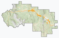
The Municipality of Crowsnest Pass is a specialized municipality in southwest Alberta, Canada. Within the Rocky Mountains adjacent to the eponymous Crowsnest Pass, the municipality formed as a result of the 1979 amalgamation of five municipalities – the Village of Bellevue, the Town of Blairmore, the Town of Coleman, the Village of Frank, and Improvement District No. 5, which included the Hamlet of Hillcrest and numerous other unincorporated communities.

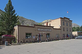
Frank is an urban community in the Rocky Mountains within the Municipality of Crowsnest Pass in southwest Alberta, Canada. It was formerly incorporated as a village prior to 1979 when it amalgamated with four other municipalities to form Crowsnest Pass.

<span class="mw-page-title-main">Coleman, Alberta</span> Unincorporated community in Alberta, Canada

Coleman is a community in the Rocky Mountains within the Municipality of Crowsnest Pass in southwest Alberta, Canada. It was formerly incorporated as a town prior to 1979 when it amalgamated with four other municipalities to form Crowsnest Pass.

<span class="mw-page-title-main">Bellevue, Alberta</span> Former village in Alberta, Canada

Bellevue is an urban community perched 4,280 feet elevation in the Rocky Mountains within the Municipality of Crowsnest Pass in southwest Alberta, Canada. It was formerly incorporated as a village prior to 1979 when it amalgamated with four other municipalities to form Crowsnest Pass.

<span class="mw-page-title-main">Langdon, Alberta</span> Hamlet in Alberta, Canada

Langdon is a hamlet in southern Alberta, Canada under the jurisdiction of Rocky View County. It previously held village status between August 31, 1907, and January 1, 1946.

Robb is a hamlet in west-central Alberta, Canada within Yellowhead County that is recognized as a designated place by Statistics Canada. It is located on Highway 47, approximately 53 kilometres (33 mi) southwest of Edson. It has an elevation of 1,140 metres (3,740 ft).

Marlboro is a hamlet in west-central Alberta, Canada within Yellowhead County. It is located on the Yellowhead Highway, approximately 25 kilometres (16 mi) west of Edson. Sundance Provincial Park is located northwest of the hamlet.

<span class="mw-page-title-main">Cadomin</span> Hamlet in Alberta, Canada

Cadomin is a hamlet in the west-central Alberta, Canada within Yellowhead County. It is located along the McLeod River in the foothills of the Rocky Mountains, approximately 50 kilometres (31 mi) south of Hinton near the Bighorn Highway. It is served by a spur of the Canadian National Railway.

Clairmont is a hamlet in northern Alberta, Canada within the County of Grande Prairie No. 1. Previously an incorporated municipality, Clairmont dissolved from village status on January 1, 1946 to become part of the Municipal District of Bear Lake No. 740.

Cardiff is a hamlet in central Alberta, Canada within Sturgeon County. It is located 3 kilometres (1.9 mi) east of Highway 2, approximately 15 kilometres (9.3 mi) north of Edmonton's city limits. The Town of Morinville is 1.6 kilometres (0.99 mi) to the west of Cardiff.

<span class="mw-page-title-main">East Coulee, Alberta</span> Former hamlet in Alberta, Canada

East Coulee is a community within the Town of Drumheller, Alberta, Canada. It was previously a hamlet within the former Municipal District (MD) of Badlands No. 7 prior to the MD's amalgamation with the former City of Drumheller on January 1, 1998. It is also recognized as a designated place by Statistics Canada.

Harvie Heights is a hamlet in Alberta, Canada, within the Municipal District of Bighorn No. 8. It is located within Alberta's Rockies on the Trans-Canada Highway approximately 4 kilometres (2.5 mi) northwest of Canmore and immediately east of the park gate for Banff National Park.

Nacmine is a community within the Town of Drumheller, Alberta, Canada. It was previously a hamlet within the former Municipal District (MD) of Badlands No. 7 prior to the MD's amalgamation with the former City of Drumheller on January 1, 1998.

Queenstown is a hamlet in southern Alberta, Canada within Vulcan County. It is located approximately 26 kilometres (16 mi) south of Highway 1 and 92 kilometres (57 mi) southeast of Calgary.

<span class="mw-page-title-main">Rosedale, Alberta</span> Former hamlet in Alberta, Canada

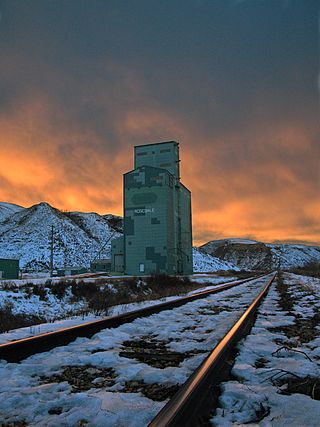
Rosedale is a community within the Town of Drumheller, Alberta, Canada. It was previously a hamlet within the former Municipal District (MD) of Badlands No. 7 prior to the MD's amalgamation with the former City of Drumheller on January 1, 1998. It is also recognized as a designated place by Statistics Canada.

<span class="mw-page-title-main">Wayne, Alberta</span> Former hamlet in Alberta, Canada

Wayne is a community within the Town of Drumheller, Alberta, Canada. It was previously a hamlet within the former Municipal District (MD) of Badlands No. 7 prior to the MD's amalgamation with the former City of Drumheller on January 1, 1998.

<span class="mw-page-title-main">Midlandvale, Alberta</span> Former hamlet in Alberta, Canada

Midlandvale is a community within the Town of Drumheller, Alberta, Canada. It was previously a hamlet within the former Municipal District of Badlands No. 7 prior to being annexed by Drumheller in 1972. Now referred to as Midland by the Town of Drumheller, the community is located within the Red Deer River valley on North Dinosaur Trail, approximately 3 km (1.9 mi) west of Drumheller's main townsite.

Eldorado is a former mining community turned ghost town located on Beaverlodge Lake in northern Saskatchewan, Canada. Its original name was Beaverlodge. Eldorado and nearby Uranium City are along Saskatchewan Highway 962, an isolated stretch of highway.

Cambria is a community within the Town of Drumheller, Alberta, Canada. It was previously a hamlet within the former Municipal District (MD) of Badlands No. 7 prior to the MD's amalgamation with the former City of Drumheller on January 1, 1998.

References

  1. 1 2 3 4 "Population and dwelling counts: Canada and designated places". Statistics Canada. February 9, 2022. Retrieved February 10, 2022.
  2. Annual Report of the Dept. of Highways of the Province of Alberta. Alberta Department of Highways. 1958. p. 44 & 46. Retrieved October 11, 2013.
  3. "Board Order: MGB 131/98" (PDF). Alberta Municipal Affairs. June 3, 1998. Archived from the original (PDF) on April 19, 2014. Retrieved August 28, 2012.
  4. Ninth Census of Canada, 1951 (PDF). Vol. SP-7 (Population: Unincorporated villages and hamlets). Dominion Bureau of Statistics. March 31, 1954. pp. 55–57. Retrieved October 24, 2021.
  5. Census of Canada, 1956 (PDF). Vol. Population of unincorporated villages and settlements. Dominion Bureau of Statistics. October 25, 1957. pp. 56–59. Retrieved October 24, 2021.
  6. "Population of unincorporated places of 50 persons and over, Alberta, 1961 and 1956". 1961 Census of Canada: Population (PDF). Series SP: Unincorporated Villages. Vol. Bulletin SP—4. Ottawa: Dominion Bureau of Statistics. April 18, 1963. pp. 63–67. Retrieved October 24, 2021.
  7. "Population of unincorporated places of 50 persons and over, 1966 and 1961 (Alberta)". Census of Canada 1966: Population (PDF). Special Bulletin: Unincorporated Places. Vol. Bulletin S–3. Ottawa: Dominion Bureau of Statistics. August 1968. pp. 184–187. Retrieved October 24, 2021.
  8. "Population of Unincorporated Places of 50 persons and over, 1971 and 1966 (Alberta)". 1971 Census of Canada: Population (PDF). Special Bulletin: Unincorporated Settlements. Vol. Bulletin SP—1. Ottawa: Statistics Canada. March 1973. pp. 204–207. Retrieved November 29, 2021.
  9. "Geographical Identification and Population for Unincorporated Places of 25 persons and over, 1971 and 1976". 1976 Census of Canada (PDF). Supplementary Bulletins: Geographic and Demographic (Population of Unincorporated Places—Canada). Vol. Bulletin 8SG.1. Ottawa: Statistics Canada. May 1978. Retrieved October 24, 2021.
  10. "Population and dwelling counts, for Canada, provinces and territories, and designated places, 2006 and 2001 censuses - 100% data (Alberta)". Statistics Canada. July 20, 2021. Retrieved October 24, 2021.
  11. Crowsnest Pass Historical Society (1979). Crowsnest and its people. Coleman: Crowsnest Pass Historical Society. p. 39. ISBN   0-88925-046-4. Archived from the original on September 24, 2015. Retrieved June 19, 2013.