Frank, Alberta

Last updated
Frank
Former village
0361 Municipality Of Crowsnest Pass, Alberta, Detailed.svg
Red pog.svg
Frank
Alberta County Point Locator.svg
Red pog.svg
Frank
Coordinates: 49°36′11″N114°24′29″W / 49.603°N 114.408°W / 49.603; -114.408 Coordinates: 49°36′11″N114°24′29″W / 49.603°N 114.408°W / 49.603; -114.408
CountryCanada
Province Alberta
Specialized municipality Municipality of Crowsnest Pass
Village September 3, 1901
AmalgamatedJanuary 1, 1979
Government
  Type Unincorporated
  Governing body Municipality of Crowsnest Pass Council
Area
 (2021) [1]
  Land4.09 km2 (1.58 sq mi)
Population
 (2021) [1]
  Total147
  Density35.9/km2 (93/sq mi)
Time zone UTC−7 (MST)
  Summer (DST) UTC−6 (MDT)

Frank is an urban community in the Rocky Mountains within the Municipality of Crowsnest Pass in southwest Alberta, Canada. It was formerly incorporated as a village prior to 1979 when it amalgamated with four other municipalities to form Crowsnest Pass.

Contents

History

The Frank Slide in 1903 Frank Slide 4-30-1903.jpg
The Frank Slide in 1903

In 1901, American entrepreneurs Sam Gebo and Henry Frank developed the first of many coal mines in the Crowsnest Pass, in the base of Turtle Mountain. In May that year the first buildings were erected in the new community of Frank, located on flat land between the Canadian Pacific Railway tracks and the mine. The community was incorporated as the Village of Frank on September 3, 1901. [2]

The community's grand opening on September 10, 1901 was an all-day event that included sporting competitions (with engraved medals for the victors), tours of the mine, a banquet, and a dance. Two special trains brought in the guests and the gourmet food (including a ton of ice cream). Henry Frank presided over the event, which was attended by the premier Frederick W. A. G. Haultain, his public works minister, and federal Minister of the Interior Clifford Sifton. [3] Frank became the first incorporated village in the Crowsnest Pass and by 1903 served 1,000 people with two dozen businesses and services, a two-story brick school, and a regional post office.

The Frank Slide of 1903 destroyed much of the mine's infrastructure, several rural businesses, and seven houses on the outskirts of Frank, killing 7090 people. However the mine reopened within weeks and the rail line was soon re-established through the slide path. Frank continued to boom, and in 190506 a new residential subdivision was developed north of the tracks to keep pace with mine production. A new zinc smelter and a new three-story hotel (Rocky Mountains Sanatorium) close to a cold sulphur spring were also constructed. A small zoo was built near the hotel.

However a period of decline soon followed. Due to market forces the zinc smelter never operated, and was converted to an ice skating arena. Fears of a second slide led to a government-ordered closure of the south townsite in 1911, and over the next several years its buildings were torn down or moved. The 1905 subdivision remained, but Frank ceased to be an important centre after the mine closed temporarily in 1912 and permanently in 1917. The sanatorium, converted to a military hospital in 1917, was torn down in 1928 after a period of abandonment. The post office was finally closed in 1968. [4] On November 3, 1978, the Government of Alberta passed the Crowsnest Pass Municipal Unification Act, which led to the formal amalgamation of the Village of Frank with the Village of Bellevue, the Town of Blairmore, the Town of Coleman, and Improvement District (ID) No. 5 on January 1, 1979. [5]

The Frank Slide was designated a Provincial Historical Resource in 1977, and in 1985, the provincial government opened a major interpretive centre in Frank that explains the Frank Slide and the coal mining history of the region. The site of the original Frank townsite is now an industrial park, and many of the historic buildings in the north subdivision are gone, including Gebo's stately mansion and the Catholic church blown down by wind in 1917. But there are a few houses that are over a hundred years old, and visitors can still see pieces of century-old wood-stave water pipes in Gold Creek, part of the foundation of the zinc plant (and the tunnel that connected it to its hilltop chimney), and an antique fire hydrant in the old closed townsite.

Demographics

Population history
of Frank
YearPop.±%
190119    
19061,178+6100.0%
1911806−31.6%
1916622−22.8%
1921401−35.5%
1926299−25.4%
1931268−10.4%
1936258−3.7%
1941204−20.9%
1946194−4.9%
1951239+23.2%
1956221−7.5%
1961223+0.9%
1966178−20.2%
1971224+25.8%
1976201−10.3%
2001 131−34.8%
2006 127−3.1%
2011 112−11.8%
2016 114+1.8%
2021 147+28.9%
Source: Statistics Canada
[6] [7] [8] [9] [10] [11] [12] [13] [1]

In the 2021 Census of Population conducted by Statistics Canada, Frank recorded a population of 147 living in 66 of its 73 total private dwellings, a change of

See also

Related Research Articles

Spruce Grove City in Alberta, Canada

Spruce Grove is a city that is 11 km (6.8 mi) west of Edmonton, Alberta in Canada. The city is adjacent to the Town of Stony Plain and is surrounded by Parkland County.

Leduc, Alberta City in Alberta, Canada

Leduc is a city in the province of Alberta, Canada. It is 33 km (21 mi) south of the provincial capital of Edmonton and is part of the Edmonton Metropolitan Region.

Drumheller Town in Alberta, Canada

Drumheller is a town on the Red Deer River in the badlands of east-central Alberta, Canada. It is 110 kilometres (68 mi) northeast of Calgary and 97 kilometres (60 mi) south of Stettler. The Drumheller portion of the Red Deer River valley, often referred to as Dinosaur Valley, has an approximate width of 2 kilometres (1.2 mi) and an approximate length of 28 kilometres (17 mi).

Wetaskiwin City in Alberta, Canada

Wetaskiwin is a city in the province of Alberta, Canada. The city is located 70 kilometres (43 mi) south of the provincial capital of Edmonton. The city name comes from the Cree word wītaskiwinihk, meaning "the hills where peace was made".

Okotoks Town in Alberta, Canada

Okotoks is a town in the Calgary Metropolitan Region of Alberta, Canada. It is on the Sheep River, approximately 18 km (11 mi) south of the Calgary. Okotoks has emerged as a bedroom community of Calgary. According to the 2016 Census, the town has a population of 28,881, making it the largest town in Alberta.

Cochrane, Alberta Town in Alberta, Canada

Cochrane is a town in the Calgary Metropolitan Region of Alberta, Canada. The town is located 18 km (11 mi) west of the Calgary city limits along Highway 1A. Cochrane is one of the fastest-growing communities in Canada, and with a population of 34,467 in 2021, it is one of the largest towns in Alberta. It is part of Calgary's census metropolitan area and a member community of the Calgary Metropolitan Region Board (CMRB). The town is surrounded by Rocky View County.

Brooks, Alberta City in Alberta, Canada

Brooks is a city in southeast Alberta, Canada that is surrounded by the County of Newell. It is located on Highway 1 and the Canadian Pacific Railway, approximately 186 km (116 mi) southeast of Calgary, and 110 km (68 mi) northwest of Medicine Hat. The city has an elevation of 760 m (2,490 ft).

Crowsnest Pass, Alberta Specialized municipality in Alberta, Canada

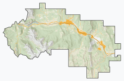
The Municipality of Crowsnest Pass is a specialized municipality in southwest Alberta, Canada. Within the Rocky Mountains adjacent to the eponymous Crowsnest Pass, the municipality formed as a result of the 1979 amalgamation of five municipalities – the Village of Bellevue, the Town of Blairmore, the Town of Coleman, the Village of Frank, and Improvement District No. 5, which included the Hamlet of Hillcrest and numerous other unincorporated communities.

Stony Plain, Alberta Town in Alberta, Canada

Stony Plain is a town in the Edmonton Metropolitan Region of Alberta, Canada that is surrounded by Parkland County. It is west of Edmonton adjacent to the City of Spruce Grove and sits on Treaty 6 land.

Strathmore, Alberta Town in Alberta, Canada

Strathmore is a town located in southern Alberta, Canada that is surrounded by Wheatland County. It is along the Trans-Canada Highway approximately 50 kilometres (30 mi) east of Calgary.

Beaumont, Alberta City in Alberta, Canada

Beaumont is a city in Leduc County within the Edmonton Metropolitan Region of Alberta, Canada. It is located at the intersection of Highway 625 and Highway 814, adjacent to the City of Edmonton and 6.0 kilometres (3.7 mi) northeast of the City of Leduc. The Nisku Industrial Park and the Edmonton International Airport are located 4.0 kilometres (2.5 mi) to the west and 8.0 kilometres (5.0 mi) to the southwest respectively.

High River Town in Alberta, Canada

High River is a town within the Calgary Metropolitan Region of Alberta, Canada. It is approximately 68 kilometres (42 mi) south of Calgary, at the junction of Alberta Highways 2 and 23. High River had a population of 13,584 in 2006.

Coleman, Alberta Former town in Alberta, Canada

Coleman is a community in the Rocky Mountains within the Municipality of Crowsnest Pass in southwest Alberta, Canada. It was formerly incorporated as a town prior to 1979 when it amalgamated with four other municipalities to form Crowsnest Pass.

Bellevue, Alberta Former village in Alberta, Canada

Bellevue is an urban community in the Rocky Mountains within the Municipality of Crowsnest Pass in southwest Alberta, Canada. It was formerly incorporated as a village prior to 1979 when it amalgamated with four other municipalities to form Crowsnest Pass.

Hillcrest, Alberta Former hamlet in Alberta, Canada

Hillcrest, also known as Hillcrest Mines, is an urban community in the Rocky Mountains within the Municipality of Crowsnest Pass in southwest Alberta, Canada. It was once a hamlet under the jurisdiction of Improvement District (ID) No. 5 prior to 1979 when the former ID No. 5 amalgamated with four other municipalities to form Crowsnest Pass.

Blairmore, Alberta Former village in Alberta, Canada

Blairmore is a community in the Rocky Mountains within the Municipality of Crowsnest Pass in southwest Alberta, Canada. It was formerly incorporated as a town prior to 1979 when it amalgamated with four other municipalities to form Crowsnest Pass. Blairmore is the principal commercial centre of Crowsnest Pass.

According to the 2011 census, the City of Edmonton had a population of 812,201 residents, compared to 3,645,257 for all of Alberta, Canada. The total population of the Edmonton census metropolitan area (CMA) was 1,159,869, making it the sixth-largest CMA in Canada, while Statistics Canada estimated the CMA's 2011 population to be 1,196,342. In 2014, a municipal census indicated the city had a population of 877,926.

Rosedale, Alberta Former hamlet in Alberta, Canada

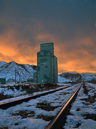
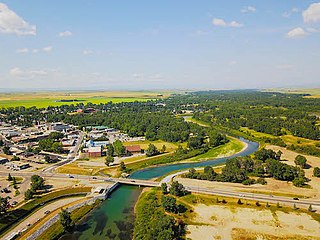
Rosedale is a community within the Town of Drumheller, Alberta, Canada. It was previously a hamlet within the former Municipal District (MD) of Badlands No. 7 prior to the MD's amalgamation with the former City of Drumheller on January 1, 1998. It is also recognized as a designated place by Statistics Canada.

Lille, Alberta Former village in Alberta, Canada

Lille is a ghost town and former village in the Crowsnest Pass area of southwest Alberta, Canada. It was a company-built coal mining community that, between 1901 and 1912, hosted a population that grew to over 400. The mines at Lille closed in 1912, due primarily to weak coal prices, increasing production costs, and the increasingly poor quality of the coal. The community was then dismantled and most of its structures were moved elsewhere. Today the site is an Alberta Provincial Historic Resource and is known for the elegant ruins of a set of Bernard-style coke ovens that was imported from Belgium.

Demographics of Calgary

In the 2011 Census, the City of Calgary had a population of 1,096,833 residents, representing 30% of the 3,645,257 residents in all of Alberta, and 3% compared to a population of 33,476,688 in all of Canada. The total population of the Calgary census metropolitan area (CMA) was 1,214,839. Calgary is the largest city in Alberta, and the third-largest municipality and fourth-largest metropolitan area in Canada, as of 2016.

References

  1. 1 2 3 4 "Population and dwelling counts: Canada and designated places". Statistics Canada. February 9, 2022. Retrieved February 10, 2022.
  2. North-West Territories Gazette. Government of the North-West Territories. October 15, 1901. p. 5.
  3. Anderson, Frank W (1968). The Frank Slide Story. Calgary: Frontiers Unlimited. p. 4.
  4. Crowsnest Pass Historical Society (1979). Crowsnest and its people. Coleman: Crowsnest Pass Historical Society. p. 40. ISBN   0-88925-046-4.
  5. "Location and History Profile – Municipality of Crowsnest Pass" (PDF). Alberta Municipal Affairs. October 15, 2021. Retrieved October 20, 2021.
  6. "Table 1: Population by sexes in 1906 and 1901". 1906 Census: Northwest Provinces (Manitoba Saskatchewan Alberta) (PDF). Vol. I: Population of 1906 Compared with 1901. Ottawa: Dominion Bureau of Statistics. 1907. pp. 55–78. Retrieved October 24, 2021.
  7. "Table 5: Population of urban centres, 1916-1946, with guide to locations". 1946 Census of Alberta (PDF). Vol. Population. Ottawa: Dominion Bureau of Statistics. August 22, 1949. pp. 397–400. Retrieved October 24, 2021.
  8. "Table 6: Population by census subdivisions, 1901–1961". 1961 Census of Canada (PDF). Series 1.1: Historical, 1901–1961. Vol. I: Population. Ottawa: Dominion Bureau of Statistics. March 8, 1963. pp. 6.77–6.83. Retrieved October 24, 2021.
  9. "Table 10: Population of incorporated cities, towns and villages, 1966 and 1961, with guide to locations". 1961 Census of Canada (PDF). Vol. Population: Incorporated Cities, Towns and Villages. Ottawa: Dominion Bureau of Statistics. October 1967. pp. 10–1 to 10–32. Retrieved October 24, 2021.
  10. "Table 2: Area and Density of Population, for Census Subdivisions Population by census subdivisions, 1971 (Alberta)". 1971 Census of Canada (PDF). Special Bulletin: Geography. Vol. Land Areas and Densities of Statistical Units. Ottawa: Statistics Canada. June 1973. pp. 2–41 to 2–44. Retrieved October 24, 2021.
  11. Population: Geographic Distributions – Census Divisions and Subdivisions, Western Provinces and the Territories. Statistics Canada. June 1977. pp. 3–41.
  12. "Population and dwelling counts, for Canada, provinces and territories, and designated places, 2006 and 2001 censuses - 100% data (Alberta)". Statistics Canada. July 20, 2021. Retrieved October 24, 2021.
  13. "Population and dwelling counts, for Canada, provinces and territories, and designated places, 2011 and 2006 censuses (Alberta)". Statistics Canada. 2012-02-08. Retrieved 2012-04-07.