
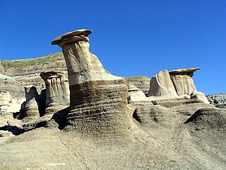
Drumheller is a town on the Red Deer River in the badlands of east-central Alberta, Canada. It is located 110 kilometres (68 mi) northeast of Calgary and 97 kilometres (60 mi) south of Stettler. The Drumheller portion of the Red Deer River valley, often referred to as Dinosaur Valley, has an approximate width of 2 kilometres (1.2 mi) and an approximate length of 28 kilometres (17 mi).

The Municipality of Crowsnest Pass is a specialized municipality in southwest Alberta, Canada. Within the Rocky Mountains adjacent to the eponymous Crowsnest Pass, the municipality formed as a result of the 1979 amalgamation of five municipalities – the Village of Bellevue, the Town of Blairmore, the Town of Coleman, the Village of Frank, and Improvement District No. 5, which included the Hamlet of Hillcrest and numerous other unincorporated communities.

Oyen is a town in east-central Alberta, Canada near the Saskatchewan boundary and north of Medicine Hat. It is on Highway 41, 4 km (2.5 mi) south of its junction with Highway 9.

Grande Cache is a hamlet in West-Central Alberta, Canada within and administered by the Municipal District of Greenview No. 16. It is located on Highway 40 approximately 145 kilometres (90 mi) northwest of Hinton and 435 kilometres (270 mi) west of Edmonton. Grande Cache overlooks the Smoky River, is at the northern edge of Alberta's Rockies, and serves as a gateway to the Willmore Wilderness Park. The hamlet held town status prior to 2019.

Alberta Provincial Highway No. 10, commonly referred to as Highway 10, is a 22 km (14 mi) highway in southern Alberta, Canada that forms a part of Hoo Doo Trail. It is located wholly within the Town of Drumheller as a result of the former City of Drumheller's amalgamation with the Municipal District of Badlands No. 7 on January 1, 1998. It begins at Highway 9 in the heart of Drumheller and extends southeast along the Red Deer River where it passes through Rosedale, then crosses Highway 56 and travels through East Coulee. It ends by splitting off into Highways 570, 564, and 569.

The Municipal District of Ranchland No. 66 is a municipal district (MD) in southwest Alberta, Canada. Containing no urban communities of any kind, its municipal office is located in Chain Lakes Provincial Park, approximately 38 km (24 mi) southwest of the Town of Nanton. Ranchland's rugged foothill terrain is unsuited for the crop agriculture practiced elsewhere in Alberta, and ranching remains the single livelihood of its inhabitants. With a 2016 population of 92, it is the least populated municipal district in Alberta, and its population density of 29 square kilometres for every resident is almost exactly equal to that of the Northwest Territories.

The Municipal District of Provost No. 52 is a municipal district (MD) in east-central Alberta, Canada, on the Alberta/Saskatchewan border. Located in Census Division No. 7, its municipal office is located in the Town of Provost.

Rosebud, Alberta is a hamlet in southern Alberta, Canada within Wheatland County. Previously an incorporated municipality, Rosebud dissolved from village status on January 1, 1946, to become part of the Municipal District of Grasswold No. 248.

Lakeland County was a municipal district in northern Alberta, Canada. It existed for just over nine years from 1998 to 2007.
East Coulee is a community within the Town of Drumheller, Alberta, Canada. It was previously a hamlet within the former Municipal District (MD) of Badlands No. 7 prior to the MD's amalgamation with the former City of Drumheller on January 1, 1998. It is also recognized as a designated place by Statistics Canada.
Nacmine is a community within the Town of Drumheller, Alberta, Canada. It was previously a hamlet within the former Municipal District (MD) of Badlands No. 7 prior to the MD's amalgamation with the former City of Drumheller on January 1, 1998.
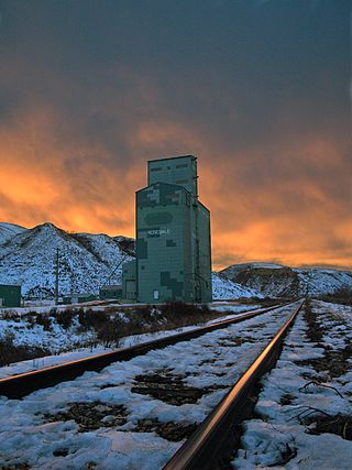
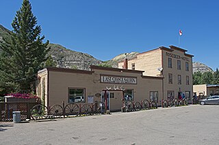
Rosedale is a community within the Town of Drumheller, Alberta, Canada. It was previously a hamlet within the former Municipal District (MD) of Badlands No. 7 prior to the MD's amalgamation with the former City of Drumheller on January 1, 1998. It is also recognized as a designated place by Statistics Canada.
Wayne is a community within the Town of Drumheller, Alberta, Canada. It was previously a hamlet within the former Municipal District (MD) of Badlands No. 7 prior to the MD's amalgamation with the former City of Drumheller on January 1, 1998.
Newcastle is a community within the Town of Drumheller, Alberta, Canada. It held village status for eight years between 1923 and 1931, and was recognized as a hamlet prior to annexation by Drumheller in 1967. The community is located within the Red Deer River valley on South Dinosaur Trail, approximately 2 km (1.2 mi) west of Drumheller's main townsite. The former hamlet of Midlandvale is located across the river to the north.
Cambria is a community within the Town of Drumheller, Alberta, Canada. It was previously a hamlet within the former Municipal District (MD) of Badlands No. 7 prior to the MD's amalgamation with the former City of Drumheller on January 1, 1998.
Lehigh is a community within the Town of Drumheller, Alberta, Canada. It was previously a hamlet within the former Municipal District (MD) of Badlands No. 7 prior to the MD's amalgamation with the former City of Drumheller on January 1, 1998.

