List of Alberta provincial highways

Last updated

Alberta provincial highway system
Alberta Highway 1.svg Alberta Highway 2.svg Alberta Highway 520.svg
Standard highway markers for Alberta
Alberta Provincial Highway System.png
Alberta's provincial highway system as of 2016
Highway names
Provincial HighwaysAlberta Highway XX (Hwy XX)
System links

    The Canadian province of Alberta has a provincial highway network consisting of over 31,400 kilometres (19,500 mi) of roads as of 2021-2022, of which 28,000 kilometres (17,000 mi) have been paved. [1]

    Contents

    All of Alberta's provincial highways are maintained by Alberta Transportation (AT), a department of the Government of Alberta. The network includes two distinct series of numbered highways:

    History

    In 1926, Alberta discontinued its system of marking highways with different colours in favour of a numbering system. [2] By 1928, the year a gravel road stretched from Edmonton to the United States border, Alberta's provincial highway network comprised 2,310 km (1,440 mi). [2]

    Prior to 1973, the expanding highway system comprised one-digit and two-digit highways, with some numbers having letter suffixes (e.g., Highway 1X, Highway 26A). [3] In 1973, a second highway system emerged, using three digits starting in the 500s and referred to as secondary roads, while the existing system continued to be referred to as provincial highways. [4] In 1974, provincial highways became known as primary highways; [5] and in 1990, secondary roads became known as secondary highways. [6]

    Secondary highways were abolished in 2000, with most becoming primary highways. [7] The expanded primary highway system was divided into two subsets: former primary highways, which became the 1–216 series; [8] and former secondary highways, which became the 500–986 series. [9] In 2010, all highways became known as provincial highways, while maintaining the two numbered series. [10] [11] Despite this, the series are still often referred to as primary and secondary highways, respectively.

    1 - 216 series

    AB-provincial highway.svg
    Alberta Provincial Highways 1-216 Series.png
    The 1 – 216 series of highways within Alberta’s provincial highway system as of 2016
    AB Provincial Highways NHS.png
    The highways within Alberta’s provincial highway system that are designated segments of Canada's National Highway System

    Alberta's 1 to 216 series of provincial highways are Alberta's main highways. They are numbered from 1 to 100, with the exception of the ring roads around Calgary and Edmonton, which are numbered 201 and 216 respectively. The numbers applied to these highways are derived from compounding the assigned numbers of the core north–south and east–west highways that intersect with the rings roads. In Calgary, Highway 201 is derived from the north-south Highway 2 and the east-west Highway 1. In Edmonton, Highway 216 is derived from the same north-south Highway 2 and the east-west Highway 16.

    Within this series, all or portions of Highways 1, 2, 3, 4, 9, 15, 16, 28, 28A, 35, 43, 49, 63, 201 and 216 are designated core routes of Canada's National Highway System (NHS). [12] Highway 28 from Highway 63 to Cold Lake is designated a NHS feeder route and Highway 58 between Rainbow Lake and Highway 88 is designated a NHS northern/remote route. [12]

    Highways 1, 2, 3, 4, 16, and 43 are considered Alberta's most important interprovincial and international highways and are divided highways (expressways) or freeways for much or all of their length. Speed limits are generally 110 km/h (68 mph) divided highways/freeways and 100 km/h (62 mph) on others. Segments of Highway 1 and Highway 16 through the national parks within Alberta's Rockies that can be 90 km/h (56 mph) or 70 km/h (43 mph).

    The Highway 15/28A/28/63 corridor between Edmonton and Fort McMurray is considered one of Alberta's most important intraprovincial highways. It is vital to the oilsands operation. 

    Although only Highways 1, 2, 3, 4, 11, 15, 16, 43, 60, 63, 100, 201, and 216 are twinned (expressways) for most of their length, the vast majority of Alberta's 1 to 216 series of highways are two-laned and paved. Only four highways within the series have segments that remained gravelled. These include segments of Highways 40, 58, and 68 and a short segment near the northern terminus of Highway 63. [13]

    Highways 1 and 16 are Trans-Canada Highway routes and are signed with TCH shields, not standard provincial shields.

    NumberLength (km)Length (mi)Southern or western terminusNorthern or eastern terminusLocal namesFormedRemovedNotes
    Alberta Highway 1.svg Hwy 1 (TCH) 534332BC-1 (TCH).svg Hwy 1 (TCH) at the B.C. border at Kicking Horse Pass Saskatchewan Highway 1.svg Hwy 1 (TCH) at the Sask. border east of Walsh Trans-Canada Highway 01941-01-01c.1941currentSigned with Trans-Canada Highway shield; passes through Banff, Calgary, and Medicine Hat.
    Alberta Highway 1 (1930s).svg Hwy 1 1370850 U.S. (Montana) border at Carway B.C. border west of Demmitt 01926-01-01192601941-01-01c.1941Replaced by Hwy 2; passes through Calgary, Red Deer, Edmonton, Peace River and Grande Prairie. [14]
    Alberta Highway 1 (1960s).svg Hwy 1 6037 Bassano Brooks 01941-01-01c.1941 [15] 01955-01-01c.1955 [16] Replaced by Hwy 36 between Brooks and Duchess; became Hwy 550 and Hwy 873 in 1973.
    Alberta Highway 1A.svg Hwy 1A 5132Alberta Highway 1.svg Hwy 1 (TCH) at Lake Louise Alberta Highway 1.svg Hwy 1 (TCH) west of Banff Bow Valley ParkwayFormer section of Hwy 1.
    Alberta Highway 1A.svg Hwy 1A 8955Alberta Highway 1.svg Hwy 1 (TCH) in Canmore Alberta Highway 1.svg Hwy 1 (TCH) in Calgary Bow Valley Trail01957-01-01c.1957currentFormer section of Hwy 1.
    Alberta Highway 1A (1970s).svg Hwy 1A 63.7 BC 1A at the B.C. border at Kicking Horse Pass Hwy 1 at Lake Louise Kicking Horse Trail01962-01-01196201990-01-01c.1990sRoute closed to automobile traffic.
    Alberta Highway 1A (1960s).svg Hwy 1A 228142 Hwy 1 west of Lake Louise Hwy 16 in Jasper Icefields Parkway01940-01-01194001959-01-011959Replaced by Hwy 93. [17]
    Alberta Highway 1A (1970s).svg Hwy 1A 116.8 Hwy 1 (16 Avenue NW) / Crowchild Trail in Calgary Hwy 2 (Deerfoot Trail) / 17 Avenue SE in Calgary   14 Street W
     6 Avenue S
     9 Avenue S
    01949-01-01194901980-01-01c.1980Former section of Hwy 1 through downtown Calgary; Hwy 1A was split into two sections when decommissioned.
    Alberta Highway 1A.svg Hwy 1A 148.7 Hwy 2 (Deerfoot Trail) in Calgary Hwy 1 in Chestermere 17 Avenue SE 01949-01-01194902013-01-012013Former section of Hwy 1 through east Calgary.
    Alberta Highway 1B (1960s).svg Hwy 1B 116.8 BC 1B at the B.C. border at Vermilion Pass Hwy 1 at Castle Junction Banff–Windermere Highway 01941-01-01194101959-01-011959Replaced by Hwy 93. [17]
    Alberta Highway 1X.svg Hwy 1X 53.1Alberta Highway 1A.svg Hwy 1A east of Exshaw Alberta Highway 1.svg Hwy 1 (TCH) south of Seebe 01961-01-01c.1961current
    Alberta Highway 2.svg Hwy 2 1273791US 89.svg US 89 at the U.S. (Montana) border at Carway Alberta Highway 43.svg Hwy 43 north of Grande Prairie  Queen Elizabeth II Highway
    (Airdrie – Edmonton)
      Deerfoot Trail
    (Calgary)
      Northern Woods and Water Route
    (Athabasca – Donnelly)
    01941-01-01c.1941currentPasses through Calgary, Edmonton, Peace River, and Red Deer.
    Alberta Highway 2 (1930s).svg Hwy 2 534332 B.C. border at Kicking Horse Pass Sask. border east of Walsh 01926-01-01192601941-01-01c.1941Replaced by Hwy 1; passed through Banff, Calgary, and Medicine Hat. [14]
    Alberta Highway 2 (1970s).svg Hwy 2 9760 BC 2 at the B.C. border west of Demmitt Hwy 34 (now Hwy 43) north of Grande Prairie 01941-01-01c.194101998-01-011998 [18] Section replaced by Hwy 43.
    Alberta Highway 2A.svg Hwy 2A 4629Alberta Highway 23.svg Hwy 23 in High River Alberta Highway 201.svg Hwy 201 in Calgary 01960-01-01c.1960currentFormer section of Hwy 2.
    Alberta Highway 2A.svg Hwy 2A 229142Alberta Highway 2.svgAlberta Highway 72.svg Hwy 2  / Hwy 72 east of Crossfield Alberta Highway 2.svg Hwy 2 in Leduc 01954-01-011954currentFormer section of Hwy 2; passes through Red Deer
    Alberta Highway 2A.svg Hwy 2A 159.3Alberta Highway 2.svg Hwy 2 south of Hondo Smith Former section of Hwy 2.
    Alberta Highway 2A.svg Hwy 2A 2717Alberta Highway 2.svg Hwy 2 west of High Prairie Alberta Highway 49.svg Hwy 49 south of Guy Former section of Hwy 2.
    Alberta Highway 2A.svg Hwy 2A 116.8Alberta Highway 2.svg Hwy 2 west of Peace River Alberta Highway 2.svg Hwy 2 in Grimshaw Former section of Hwy 2.
    Alberta Highway 2A (1970s).svg Hwy 2A 2012 Hwy 2 north of Nanton Hwy 23 in High River 01996-01-011996 [19] [20] Former section of Hwy 2.
    Alberta Highway 2A (1970s).svg Hwy 2A 116.8 Hwy 1 in Calgary Hwy 2 north of Calgary Barlow Trail 01980-01-01c.1980sFormer section of Hwy 2.
    Alberta Highway 2A (1960s).svg Hwy 2A 85.0 Hwy 2 (109 Street) in Edmonton Hwy 2 (St. Albert Trail  / 118 Avenue) in Edmonton  Whyte Avenue
      University Avenue
      Saskatchewan Drive
      Groat Road
    01955-01-01195501970-02-191970Downtown Edmonton bypass via Groat Bridge.
    Alberta Highway 3.svg Hwy 3 324201BC-3 (Crowsnest).svg Hwy 3 at the B.C. border at Crowsnest Pass Alberta Highway 1.svgAlberta Highway 41A.svg Hwy 1 (TCH)  / Hwy 41A in Medicine Hat Crowsnest Highway 01926-01-011926currentSigned with Crowsnest Highway shield; passes through Lethbridge.
    Alberta Highway 3A.svg Hwy 3A 42.5Alberta Highway 3.svg Hwy 3 at Lundbreck Falls Alberta Highway 3.svg Hwy 3 at Lundbreck 01967-01-011967currentFormer section of Hwy 3; unsigned.
    Alberta Highway 3A.svg Hwy 3A 85.0Alberta Highway 3.svg Hwy 3 west of Monarch Alberta Highway 3.svgAlberta Highway 23.svg Hwy 3  / Hwy 23 east of Monarch01996-01-011996currentFormer section of Hwy 3.
    Alberta Highway 3A.svg Hwy 3A 0.650.40Alberta Highway 3.svg Hwy 3 east of Coalhurst Lethbridge city limitsWestside Drive01967-01-011967currentFormer section of Hwy 3; unsigned.
    Alberta Highway 3A.svg Hwy 3A 74.3Business route through Barnwell 01998-01-011998currentFormer section of Hwy 3; unsigned.
    Alberta Highway 3A (1970s).svg Hwy 3A 63.7Hwy 3 east of Coalhurst Hwy 3 in Lethbridge Westside Drive
     Bridge Drive
    01967-01-01196701980-01-01c.1980sFormer section of Hwy 3; all but a 650 m section, was decommissioned when the area was annexed by the City of Lethbridge.
    Alberta Highway 4.svg Hwy 4 10364I-15.svg I-15 at the U.S. (Montana) border at Coutts Alberta Highway 3.svg Hwy 3 in Lethbridge 01926-01-011926current
    Alberta Highway 5.svg Hwy 5 12980 Waterton Park Alberta Highway 3.svg Hwy 3 in Lethbridge Cowboy Trail
    (Waterton Lakes N.PCardston)
    01926-01-011926current
    Alberta Highway 6.svg Hwy 6 7446MT-17.svg MT 17 at the U.S. (Montana) border at Chief Mountain Alberta Highway 3.svg Hwy 3 at Pincher Station Cowboy Trail
    (Waterton Lakes N.P – Pincher Station)
    01926-01-011926current
    Alberta Highway 7.svg Hwy 7 2616Alberta Highway 22.svg Hwy 22 in Black Diamond Alberta Highway 2.svgAlberta Highway 547.svg Hwy 2  / Hwy 547 at Aldersyde
    Alberta Highway 7 (1960s).svg Hwy 7 1711 Black Diamond Longview Section replaced by Hwy 22.
    Alberta Highway 8.svg Hwy 8 3119Alberta Highway 22.svg Hwy 22 north of Redwood Meadows Alberta Highway 2.svg Hwy 2 in Calgary Glenmore Trail 9 km (5.6 mi) section in Calgary between Stoney Trail on the west and east sides (Hwy 201) is unsigned.
    Alberta Highway 8 (1960s).svg Hwy 8 116.8 Hwy 1A (14 Street NW) in Calgary Bowness Park in Bowness  Kensington Road
     Parkdale Boulevard
     3 Avenue NW
     Bowness Road
     85 Street NW
    01964-01-011964Serviced the former towns of Montgomery and Bowness. Decommissioned after the towns were annexed by the City of Calgary.
    Alberta Highway 9.svg Hwy 9 324201Alberta Highway 1.svgAlberta Highway 797.svg Hwy 1 (TCH)  / Hwy 797 north of Langdon Saskatchewan Highway 7 (jct).svg Hwy 7 at the Sask. border at Alsask, SK
    Alberta Highway 10.svg Hwy 10 2314Alberta Highway 9.svgAlberta Highway 56.svg Hwy 9  / Hwy 56 in Drumheller Alberta Highway 564.svgAlberta Highway 569.svg Hwy 564  / Hwy 569 east of East Coulee Hoo Doo TrailEntire route is in the Town of Drumheller.
    Alberta Highway 10X.svg Hwy 10X 63.7Alberta Highway 10.svgAlberta Highway 56.svg Hwy 10  / Hwy 56 at Rosedale Wayne Entire route is in the Town of Drumheller.
    Alberta Highway 11.svg Hwy 11 318198Alberta Highway 93.svg Hwy 93 at Saskatchewan River Crossing Alberta Highway 12.svg Hwy 12 east of Nevis David Thompson HighwayPasses through Red Deer.
    Alberta Highway 11A.svg Hwy 11A 127.5Alberta Highway 11.svgAlberta Highway 756.svg Hwy 11  / Hwy 756 west of Rocky Mountain House Alberta Highway 11.svgAlberta Highway 22.svgAlberta Highway 598.svg Hwy 11  / Hwy 22  / Hwy 598 in Rocky Mountain HouseFormer section of Hwy 11.
    Alberta Highway 11A.svg Hwy 11A 1711Alberta Highway 20.svg Hwy 20 in Sylvan Lake Alberta Highway 2A.svg Hwy 2A in Red Deer 01987-01-01c.1987currentFormer section of Hwy 11.
    Alberta Highway 11A.svg Hwy 11A 138.1 Hwy 11 at Benalto Hwy 20 in Sylvan Lake 01987-01-01c.198702008-01-01c.2008Former section of Hwy 11.
    Alberta Highway 11X (1970s).svg Hwy 11X 2817 Hwy 11 at Benalto Hwy 2 in Red Deer 01985-01-01c.198501987-01-01c.1987Designation of Sylvan Lake bypass during construction; replaced by Hwy 11.
    Alberta Highway 12.svg Hwy 12 364226Alberta Highway 22.svg Hwy 22 north of Rocky Mountain House Saskatchewan Highway 51 (jct).svg Hwy 51 at the Sask. border at Compeer
    Alberta Highway 12A.svg Hwy 12A 95.6Alberta Highway 12.svg Hwy 12 at Bentley Alberta Highway 12.svg Hwy 12 at Gull Lake 02017-01-012017currentFormer section of Hwy 12.
    Alberta Highway 12 (1970s).svg Hwy 12 9056 Hwy 20 / Hwy 51 at Bentley Hwy 39 at Alsike 01980-01-01c.1980sSection replaced by Hwy 20.
    Alberta Highway 13.svg Hwy 13 366227 Alder Flats Saskatchewan Highway 14 (jct).svg Hwy 14 at the Sask. border east of Hayter
    Alberta Highway 13A.svg Hwy 13A 74.3Alberta Highway 13.svg Hwy 13 at Westerose Alberta Highway 13.svg Hwy 13 east of Ma-Me-O Beach 02000-01-01c.2000scurrentFormer Hwy 13 through Ma-Me-O Beach.
    Alberta Highway 13A.svg Hwy 13A 85.0 Camrose bypassCamrose Drive01988-01-011988currentMaintained by the City of Camrose.
    Alberta Highway 13A (1970s).svg Hwy 13A 53.1 Hwy 2A / Hwy 13 in Wetaskiwin Hwy 13 / Hwy 814 north of WetaskiwinAlternate route through Wetaskiwin.
    Alberta Highway 14.svg Hwy 14 257160Alberta Highway 2.svg Hwy 2 in Edmonton Saskatchewan Highway 40 (jct).svg Hwy 40 at the Sask. border west of Marsden, SK Poundmaker Trail
    Alberta Highway 14A (1960s).svg Hwy 14A 31.9 Downtown Edmonton Hwy 14 (Whyte Avenue) in Edmonton  Connors Road
     83 Street
    01960-01-01c.196001970-01-01c.1970
    Alberta Highway 14A (1960s).svg Hwy 14A 63.7 Edmonton Hwy 14 (Sherwood Park Freeway) near Sherwood Park 79 Avenue01968-01-01196801970-01-01c.1970sFormer section of Hwy 14.
    Alberta Highway 14X (1970s).svg Hwy 14X 31.9 Hwy 14 (Sherwood Park Freeway) between Edmonton and Sherwood Park Hwy 16A (Baseline Road) between Edmonton and Sherwood Park01950-01-01c.1950s01999-01-011999 [21] Replaced by Hwy 216.
    Alberta Highway 14X (1970s).svg Hwy 14X 31.9 Baseline Road between Edmonton and Sherwood Park Hwy 16 between Edmonton and Sherwood Park01996-01-011996 [22] 01999-01-011999 [21] Replaced section of Hwy 16A; replaced by Hwy 216.
    Alberta Highway 15.svg Hwy 15 9358Alberta Highway 16.svg Hwy 16 (TCH) in Edmonton Alberta Highway 16.svgAlberta Highway 855.svg Hwy 16 (TCH)  / Hwy 855 south of Mundare 01940-01-011940currentFormer section of Hwy 16.
    Alberta Highway 15 (1930s).svg Hwy 15 8050 Hwy 16 in downtown Edmonton Hwy 16 south of Mundare 01930-01-01c.1930s01940-01-011940Passed through Elk Island National Park; replaced by Hwy 16.
    Alberta Highway 16.svg Hwy 16 (TCH) 634394BC-16 (TCH).svg Hwy 16 (TCH) at the B.C. border at Yellowhead Pass Saskatchewan Highway 16.svg Hwy 16 (TCH) at the Sask. border in Lloydminster   Yellowhead Highway
      Trans-Canada Highway
    Signed with Trans-Canada Highway shield; cosigned with Yellowhead Highway shield; passes through Jasper, Edmonton, and Lloydminster.
    Alberta Highway 16 (1930s).svg Hwy 16 9861 Hwy 15 in Edmonton Hwy 15 south of Mundare 01930-01-01c.1930s01940-01-011940Passed through Fort Saskatchewan; section replaced by Hwy 15.
    Alberta Highway 16A.svg Hwy 16A 148.7Alberta Highway 16.svg Hwy 16 (TCH) west of Evansburg Alberta Highway 16.svgAlberta Highway 22.svg Hwy 16 (TCH)  / Hwy 22 at Entwistle Former section of Hwy 16.
    Alberta Highway 16A.svg Hwy 16A 3321Alberta Highway 16.svg Hwy 16 (TCH) west of Stony Plain Alberta Highway 216.svg Hwy 216 in Edmonton Parkland Highway01997-01-011997 [23] currentFormer section of Hwy 16.
    Alberta Highway 16A.svg Hwy 16A 95.6Business route through Vegreville 01986-01-011986currentFormer section of Hwy 16.
    Alberta Highway 16A (1970s).svg Hwy 16A 169.9 Hwy 16 in Edmonton Edmonton eastern city limits01950-01-01c.1950s01980-01-01c.1980sFormer section of Hwy 16 through downtown Edmonton.
    Alberta Highway 16A (1970s).svg Hwy 16A 74.3 Edmonton city limits Hwy 16 east of Edmonton01950-01-01c.1950s01996-01-011996 [22] Portion replaced by Hwy 14X (now Hwy 216).
    Alberta Highway 16X (1970s).svg Hwy 16X 3622 Hwy 16 west of Stony Plain Hwy 2 / Hwy 16 in Edmonton 01970-01-01c.1970s01997-01-011997 [23] Replaced by Hwy 16.
    Alberta Highway 17.svgSaskatchewan Highway 17 (jct).svg Hwy 17 13483 Sask. border in Dillberry Lake Provincial Park Alberta Highway 641.svg Hwy 641 near Onion Lake 01940-01-01c.1940scurrentRuns along the Alberta-Saskatchewan border; cosigned with SK 17.
    Alberta Highway 17 (1930s).svg Hwy 17 148.7 Hwy 16 at Manly Corner Onoway 01930-01-01c.1930s01940-01-01c.1940s [24] [25] Replaced by Hwy 43.
    Alberta Highway 18.svg Hwy 18 161100Alberta Highway 43.svg Hwy 43 at Green Court Alberta Highway 63.svgAlberta Highway 656.svg Hwy 63  / Hwy 656 near Thorhild
    Alberta Highway 18 (1970s).svg Hwy 18 9760Hwy 933 (now Hwy 33) at Barrhead Swan Hills 01977-01-01c.1977Section replaced by Hwy 33.
    Alberta Highway 19.svg Hwy 19 127.5Alberta Highway 60.svg Hwy 60 at Devon Alberta Highway 2.svgAlberta Highway 625.svg Hwy 2  / Hwy 625 at Nisku 01982-01-01c.1982current
    Alberta Highway 19 (1960s).svg Hwy 19 7043 Hwy 12 (now Hwy 20) at Winfield Hwy 2 (now Hwy 2A) in Wetaskiwin 01969-01-01c.1969Replaced by Hwy 13.
    Alberta Highway 20.svg Hwy 20 11068Alberta Highway 11.svg Hwy 11 in Sylvan Lake Alberta Highway 39.svg Hwy 39 at Alsike
    Alberta Highway 20A.svg Hwy 20A 31.9Alberta Highway 20.svg Hwy 20 east of Rimbey Alberta Highway 20.svgAlberta Highway 53.svg Hwy 20  / Hwy 53 north of RimbeyFormer Hwy 20.
    Alberta Highway 21.svg Hwy 21 328204Alberta Highway 1.svg Hwy 1 (TCH) east of Strathmore Alberta Highway 15.svg Hwy 15 in Fort Saskatchewan
    Alberta Highway 21A (1960s).svg Hwy 21A 3321 Hwy 9 at Beiseker Hwy 21 east of Carbon 01958-01-01195801962-01-01c.1962Former section of Hwy 21; replaced by Hwy 26 (now Hwy 575 and Hwy 806).
    Alberta Highway 21A (1970s).svg Hwy 21A 53.1 Hwy 21 southeast of Nevis Hwy 12 east of Nevis01991-01-01c.1991Replaced by Hwy 11.
    Alberta Highway 22.svg Hwy 22 574357Alberta Highway 3.svg Hwy 3 west of Lundbreck Alberta Highway 18.svg Hwy 18 north of Mayerthorpe Cowboy Trail
    Alberta Highway 22 (1970s).svg Hwy 22 1711 Hwy 553 (now Hwy 22) near Priddis Hwy 2 (now Hwy 2A) south of Calgary 01976-01-01c.1976Replaced by Hwy 22X.
    Alberta Highway 22X.svg Hwy 22X 5434Alberta Highway 22.svg Hwy 22 near Priddis Alberta Highway 24.svgAlberta Highway 901.svg Hwy 24  / Hwy 901 south of Cheadle 01976-01-01c.1976currentFormer Hwy 22 west of Calgary.
    Alberta Highway 23.svg Hwy 23 13886Alberta Highway 3.svg Hwy 3 near Monarch Alberta Highway 2A.svg Hwy 2A in High River
    Alberta Highway 24.svg Hwy 24 6943Alberta Highway 23.svgAlberta Highway 542.svg Hwy 23  / Hwy 542 north of Vulcan Alberta Highway 1.svg Hwy 1 (TCH) north of Cheadle
    Alberta Highway 25.svg Hwy 25 7245Alberta Highway 3.svg Hwy 3 in Lethbridge Alberta Highway 526.svg Hwy 526 west of Enchant
    Alberta Highway 26.svg Hwy 26 8251Alberta Highway 13.svg Hwy 13 in Camrose Alberta Highway 14.svg Hwy 14 west of Kinsella 01970-01-01c.1970scurrent
    Alberta Highway 26 (1960s).svg Hwy 26 5232 Hwy 9 south of Carbon Hwy 9 at Beiseker 01970-01-011970Replaced by portions of Hwy 575, Hwy 806, and Hwy 836.
    Alberta Highway 27.svg Hwy 27 15093Alberta Highway 22.svgAlberta Highway 584.svg Hwy 22  / Hwy 584 in Sundre Alberta Highway 9.svgAlberta Highway 56.svg Hwy 9  / Hwy 56 east of Morrin
    Alberta Highway 28.svg Hwy 28 293182Alberta Highway 16.svg Hwy 16 (TCH) in Edmonton Cold Lake
    Alberta Highway 28.svg Hwy 28 4930 Hwy 36 at St. Brides Hwy 41 east of St. Paul 02006-01-012006Section replaced by Hwy 29.
    Alberta Highway 28A.svg Hwy 28A 1811Alberta Highway 15.svg Hwy 15 in Edmonton Alberta Highway 28.svg Hwy 28 at Gibbons 01980-01-01c.1980scurrentFormer section of Hwy 37.
    Alberta Highway 28A (1970s).svg Hwy 28A 31.9 Hwy 28 north of Edmonton CFB Edmonton Access road to CFB Edmonton.
    Alberta Highway 28A (1970s).svg Hwy 28A 4629 Hwy 28  / Hwy 36 at Ashmont Hwy 28 / Hwy 41 at Hoselaw 02006-01-012006Replaced by Hwy 28.
    Alberta Highway 28X (1970s).svg Hwy 28X 138.1 Hwy 28 near Beaver Crossing SK 55 at the Sask. border near Cherry Grove 01977-01-01c.1977Replaced by Hwy 55.
    Alberta Highway 29.svg Hwy 29 15294Alberta Highway 15.svg Hwy 15 west of Lamont Alberta Highway 41.svg Hwy 41 east of St. Paul 02006-01-012006current
    Alberta Highway 29 (1970s).svg Hwy 29 63.7 Spring Lake (formerly Edmonton Beach) Hwy 16 (now Hwy 16A) west of Stony Plain  Range Road 15
     Township Road 530
    01985-01-01c.1985
    Alberta Highway 30 (1970s).svg Hwy 30 3.52.2 Kapasiwin Hwy 16 east of Wabamun  Range Road 42
     Range Road 35
    01994-01-01c.1994
    Alberta Highway 31.svg Hwy 31 42.5Alberta Highway 16.svg Hwy 16 (TCH) east of Gainford Alberta Highway 759.svg Hwy 759 at Seba Beach
    Alberta Highway 32.svg Hwy 32 14791Alberta Highway 16.svg Hwy 16 (TCH) west of Carrot Creek Alberta Highway 33.svg Hwy 33 at Swan Hills
    Alberta Highway 33.svg Hwy 33 219136Alberta Highway 43.svg Hwy 43 east of Gunn Alberta Highway 2.svg Hwy 2 east of Kinuso Grizzly Trail
    Alberta Highway 33 (1970s).svg Hwy 33 106.2 Hwy 43 south of Onoway Alberta Beach 01985-01-01c.1985Section replaced by Hwy 633.
    Alberta Highway 34 (1970s).svg Hwy 34 15294 Hwy 2 north of Grande Prairie Hwy 2 (now Hwy 49) north of Guy 01939-01-01193901998-01-011998 [18] 47 km (29 mi) section between Valleyview and Guy replaced by Hwy 43 (now Hwy 49) in the early 1990s; remainder replaced by Hwy 43.
    Alberta Highway 34A (1960s).svg Hwy 34A 4729 Hwy 34 (now Hwy 49) north of Valleyview Hwy 2 (now Hwy 2A) west of High Prairie 01959-01-01195901966-01-011966Former Hwy 34.
    Alberta Highway 35.svg Hwy 35 465289Alberta Highway 2.svg Hwy 2 north of Grimshaw NWT-1.svg Highway 1 at the N.W.T. border north of Indian Cabins Mackenzie Highway Signed with Mackenzie Highway shield.
    Alberta Highway 36.svg Hwy 36 681423Alberta Highway 4.svg Hwy 4 at Warner Alberta Highway 55.svg Hwy 55 at Lac La Biche Veterans Memorial Highway
    Alberta Highway 37.svg Hwy 37 6742Alberta Highway 43.svg Hwy 43 west of Onoway Alberta Highway 15.svg Hwy 15 west of Fort Saskatchewan
    Alberta Highway 38.svg Hwy 38 2516Alberta Highway 28.svg Hwy 28 at Redwater Alberta Highway 45.svg Hwy 45 north of Bruderheim
    Alberta Highway 38 (1960s).svg Hwy 38 3.22.0 Stony Plain Road (former Hwy 16A)79 Avenue (now Whitemud Drive)156 Street01962-01-01c.1962Serviced the former town of Jasper Place; decommissioned when the town was annexed by the city of Edmonton.
    Alberta Highway 39.svg Hwy 39 9157Alberta Highway 22.svg Hwy 22 east of Drayton Valley Alberta Highway 2.svg Hwy 2 in Leduc
    Alberta Highway 40.svg Hwy 40 3.82.4Alberta Highway 3.svg Hwy 3 at Coleman Forestry Trunk Road at the Municipality of Crowsnest Pass boundary Forestry Trunk Road
    Alberta Highway 40.svg Hwy 40 10465Alberta Highway 541.svg Hwy 541 / Forestry Trunk Road west of Longview Alberta Highway 1.svg Hwy 1 (TCH) south of Seebe Kananaskis TrailAnnually closed between Peter Lougheed Provincial Park and Hwy 541 from December 1 – June 14. [26]
    Alberta Highway 40.svg Hwy 40 4629Alberta Highway 1A.svg Hwy 1A near Ghost Lake Alberta Highway 579.svg Hwy 579 / Forestry Trunk Road west of Water Valley Forestry Trunk Road
    Alberta Highway 40.svg Hwy 40 434270Alberta Highway 734.svg Hwy 734 at Lovett River Alberta Highway 43.svg Hwy 43 in Grande Prairie Bighorn Highway
    Alberta Highway 40 (1960s).svg Hwy 40 2415 U.S. (Montana) border at Whiskey Gap Hwy 2 south Cardston 01971-01-011971Border crossing closed; majority of route replaced by Hwy 501

    . [27] [28]

    Alberta Highway 41.svg Hwy 41 688428MT-sec-232.svg S-232 at the U.S. (Montana) border at Wild Horse Alberta Highway 55.svg Hwy 55 at La Corey Buffalo Trail
    Alberta Highway 41A.svg Hwy 41A 159.3Alberta Highway 1.svgAlberta Highway 3.svg Hwy 1 (TCH)  / Hwy 3 at Medicine Hat Alberta Highway 41.svg Hwy 41 east of Medicine HatFormer Hwy 41.
    Alberta Highway 42.svg Hwy 42 4427Alberta Highway 2A.svgAlberta Highway 592.svg Hwy 2A  / Hwy 592 at Penhold Alberta Highway 21.svg Hwy 21 west of Lousana
    Alberta Highway 43.svg Hwy 43 495308BC-2.svg Hwy 2 at the B.C. border near Demmitt Alberta Highway 16.svg Hwy 16 (TCH) at Manly Corner 01940-01-01c.1940scurrentPasses through Grande Prairie.
    Alberta Highway 43 (1970s).svg Hwy 43 7748 Hwy 2  / Hwy 49 west of Donnelly Hwy 34 (now Hwy 43) in Valleyview 01990-01-01c.199001998-01-011998 [18] Section replaced by Hwy 49.
    Alberta Highway 43X.svg Hwy 43X 42.5Range Road 63 (116 Street) north of Grande Prairie Hwy 2  / Hwy 43 at Clairmont 02010-01-01201002019-01-012019Replaced by Hwy 43 when extension to 100 Avenue in Grande Prairie
    Alberta Highway 44.svg Hwy 44 171106Alberta Highway 16.svg Hwy 16 (TCH) west of Acheson Alberta Highway 2.svg Hwy 2 near Hondo
    Alberta Highway 45.svg Hwy 45 231144Alberta Highway 15.svg Hwy 15 south of Bruderheim Saskatchewan Highway 3 (jct).svg Hwy 3 at the Sask. border near Alcurve
    Alberta Highway 46 (1970s).svg Hwy 46 15294 Hwy 28 at Radway Hwy 36 at Lac La Biche 01978-01-01c.1978Replaced by portions of Hwy 55 and Hwy 63. [29] [30]
    Alberta Highway 47.svg Hwy 47 6037Alberta Highway 40.svg Hwy 40 at Coalspur Alberta Highway 16.svg Hwy 16 (TCH) west of Edson
    Alberta Highway 48.svg Hwy 48 2516NWT-5.svg Highway 5 at NWT Boundary at Fort Smith, NWT Hay Camp Road in Fort Fitzgerald 02020-01-012020current
    Alberta Highway 48 (1970s).svg Hwy 48 11471 S-232 at the U.S. (Montana) border at Wild Horse Hwy 1 west of Irvine 01979-01-011979Replaced by Hwy 41. [31] [32]
    Alberta Highway 49.svg Hwy 49 266165BC-49.svg Hwy 49 at the B.C. border west of Bay Tree Alberta Highway 43.svg Hwy 43 in Valleyview Northern Woods and Water Route
    Alberta Highway 50.svg Hwy 50 148.7Alberta Highway 12.svg Hwy 12 at Tees Alberta Highway 21.svg Hwy 21 at Mirror
    Alberta Highway 51 (1970s).svg Hwy 51 3622 Hwy 761 north of Leslieville Hwy 12  / Hwy 20 at Bentley 01950-01-01c.1950s01985-01-01c.1985Replaced by Hwy 12. [33] [34]
    Alberta Highway 52.svg Hwy 52 2415Alberta Highway 5.svg Hwy 5 at Welling Station Alberta Highway 4.svg Hwy 4 at Craddock
    Alberta Highway 53.svg Hwy 53 222138Alberta Highway 22.svg Hwy 22 west of Rimbey Alberta Highway 36.svgAlberta Highway 608.svg Hwy 36  / Hwy 608 east of Forestburg
    Alberta Highway 54.svg Hwy 54 6943Alberta Highway 22.svgAlberta Highway 591.svg Hwy 22  / Hwy 591 west of Caroline Alberta Highway 2.svg Hwy 2 at Innisfail
    Alberta Highway 55.svg Hwy 55 263163Alberta Highway 2.svg Hwy 2 in Athabasca Saskatchewan Highway 55 (jct).svg Hwy 55 at the Sask. border east of Cherry Grove Northern Woods and Water Route 01976-01-01c.1976current
    Alberta Highway 55 (1970s).svg Hwy 55 159.3 Hwy 16 east of Edmonton Hwy 15 in Fort Saskatchewan 01976-01-01c.1976Replaced by Hwy 21.
    Alberta Highway 56.svg Hwy 56 246153Alberta Highway 1.svg Hwy 1 (TCH) northwest of Bassano Alberta Highway 13.svgAlberta Highway 834.svg Hwy 13  / Hwy 834 east of Camrose
    Alberta Highway 57 (1970s).svg Hwy 57 8251 Hwy 39 at Alsike Hwy 16 at Entwistle 01979-01-011979Replaced by Hwy 22 and Hwy 39. [35] [36]
    Alberta Highway 58.svg Hwy 58 325202 Rainbow Lake Garden River
    Alberta Highway 58A (1960s).svg Hwy 58A 2214 Fort Vermilion Hwy 58 north of Fort Vermilion 01970-01-01c.197001973-01-01c.1973Replaced by Hwy 67 (now Hwy 88).
    Alberta Highway 59.svg Hwy 59 6239Alberta Highway 43.svg Hwy 43 northwest of Hythe Alberta Highway 2.svg Hwy 2 north of Sexsmith
    Alberta Highway 60.svg Hwy 60 3522Alberta Highway 39.svg Hwy 39 east of Calmar Alberta Highway 16.svg Hwy 16 (TCH) at Acheson Devonian Way
    Alberta Highway 61.svg Hwy 61 14791Alberta Highway 4.svgAlberta Highway 846.svg Hwy 4  / Hwy 846 at Stirling Alberta Highway 889.svg Hwy 889 at Manyberries Red Coat Trail 01959-01-011959current
    Alberta Highway 62.svg Hwy 62 5232MT-sec-213.svg S-213 at the U.S. (Montana) border south of Del Bonita Alberta Highway 5.svg Hwy 5 at Magrath
    Alberta Highway 63.svg Hwy 63 434270Alberta Highway 28.svgAlberta Highway 829.svg Hwy 28  / Hwy 829 east of Radway Winter road north of Fort MacKay 01962-01-011962currentPasses through Fort McMurray.
    Alberta Highway 64.svg Hwy 64 12678Cecil Lake Road at the B.C. border near Bear Canyon Alberta Highway 2.svg Hwy 2 southwest of Fairview
    Alberta Highway 64A.svg Hwy 64A 6.64.1Alberta Highway 64.svgAlberta Highway 682.svg Hwy 64  / Hwy 682 west of Fairview Alberta Highway 2.svgAlberta Highway 732.svg Hwy 2  / Hwy 732 in Fairview
    Alberta Highway 66.svg Hwy 66 2817 Don Getty Wildland Provincial Park Alberta Highway 22.svgAlberta Highway 762.svg Hwy 22  / Hwy 762 south of Bragg Creek
    Alberta Highway 67 (1970s).svg Hwy 67 428266 Hwy 2 at Slave Lake Hwy 58 north of Fort Vermilion 01973-01-01c.197301988-01-011988Replaced by Hwy 88.
    Alberta Highway 68.svg Hwy 68 3723Alberta Highway 40.svg Hwy 40 at Bow Valley Provincial Park Alberta Highway 1.svg Hwy 1 (TCH) east of Morley Sibbald Creek Trail
    Alberta Highway 69.svg Hwy 69 148.7 Hwy 63 in Fort McMurray Saprae Creek Airport Road01975-01-01c.197502014-01-01c.2014Reverted to R.M. of Wood Buffalo. [37]
    Alberta Highway 72.svg Hwy 72 3321Alberta Highway 2.svgAlberta Highway 2A.svg Hwy 2  / Hwy 2A south of Crossfield Alberta Highway 9.svgAlberta Highway 806.svg Hwy 9  / Hwy 806 at Beiseker 01980-01-01c.1980scurrentFormer Hwy 572.
    Alberta Highway 88.svg Hwy 88 428266Alberta Highway 2.svg Hwy 2 at Slave Lake Alberta Highway 58.svg Hwy 58 north of Fort Vermilion Bicentennial Highway01988-01-011988currentSigned with Bicentennial Highway shield; former Hwy 67
    Alberta Highway 92 (1970s).svg Hwy 92 2415 Hwy 28 west of Ardmore Township Road 643 west of Cold Lake 01981-01-01c.198101985-01-01c.1985Former Hwy 992; [38] [39] replaced by Hwy 892. [40] [41]
    Alberta Highway 93.svg Hwy 93 265165BC-93.svg Hwy 93 at the B.C. border at Vermilion Pass Alberta Highway 16.svg Hwy 16 (TCH) at Jasper   Banff–Windermere Highway
     Icefields Parkway
    01959-01-011959current
    Alberta Highway 93A.svg Hwy 93A 2415Alberta Highway 93.svg Hwy 93 at Athabasca Falls Alberta Highway 93.svg Hwy 93 east of Marmot Basin
    Alberta Highway 93A.svg Hwy 93A 1.71.1Alberta Highway 93.svg Hwy 93 south Jasper Alberta Highway 16.svg Hwy 16 (TCH) at Jasper
    SPF 7.14.4 Edmonton city limits Hwy 216 in Sherwood Park Sherwood Park Freeway01999-01-011999currentUnsigned Hwy 100; former Hwy 14.
    Alberta Highway 201.svg Hwy 201 9257 Calgary ring road  Stoney Trail
      Tsuut’ina Trail
    01990-01-01c.1990scurrentWest segment opening 2024.
    Alberta Highway 216.svg Hwy 216 7748 Edmonton ring road Anthony Henday Drive 01992-01-011992current
    •       Former

    X series

    The roads in the X series are typically highways that are planned realignments or spurs of existing highways. The numbers applied to each highway in the X series are derived from the highway that is planned for realignment or spurred from (e.g. Highway 16X will be a realignment of Highway 16, and Highway 10X is spur from Highway 10).

    NumberLength (km)Length (mi)Southern or western terminusNorthern or eastern terminusLocal namesFormedRemovedNotes
    Alberta Highway 1X.svg Hwy 1X 53.1 Hwy 1A east of Exshaw Hwy 1 south of Seebe 01961-01-01c.1961current
    Alberta Highway 1X.svg Hwy 1X Strathmore bypassproposedROW located south of Strathmore. [13]
    Alberta Highway 1X.svg Hwy 1X Medicine Hat bypassproposedROW located south of Medicine Hat. [13]
    Alberta Highway 2X.svg Hwy 2X Hwy 2  / Hwy 3 west of Fort Macleod Hwy 2 / Hwy 3 east of Fort MacleodproposedStage 1 of Fort Macleod bypass; [42] ROW located south of Fort Macleod. [13]
    Alberta Highway 2X.svg Hwy 2X Claresholm bypassproposedROW located east of Claresholm. [13]
    Alberta Highway 2X.svg Hwy 2X Nanton bypassproposedROW located east of Nanton. [13]
    Alberta Highway 2X (1970s).svg Hwy 2X 106.2 Hwy 2 east of De Winton Hwy 2 / Hwy 22X in Calgary Deerfoot Trail 02003-01-012003Temporary designation during construction; replaced by Hwy 2 when completed. [43]
    Alberta Highway 3X.svg Hwy 3X Crowsnest Pass bypassproposedROW located south of Crowsnest Pass. [13]
    Alberta Highway 3X.svg Hwy 3X Pincher Creek realignmentproposedROW located south of Hwy 3 to allow for a proposed interchange at Hwy 6. [13] [44]
    Alberta Highway 3X.svg Hwy 3X Hwy 3 west of Fort Macleod Hwy 2X west of Fort MacleodproposedStage 2 of Fort Macleod bypass; [42] ROW located south of Fort Macleod. [13]
    Alberta Highway 3X.svg Hwy 3X Hwy 3 west of Coalhurst Hwy 3 west of Chin proposed Lethbridge bypass; ROW located north of Lethbridge. [13]
    Alberta Highway 4X.svg Hwy 4X Hwy 4 southeast of Lethbridge Hwy 3X east of LethbridgeproposedLethbridge bypass; ROW located east of Lethbridge. [13]
    Alberta Highway 6X.svg Hwy 6X Pincher Creek bypassproposedROW located east of Pincher Creek. [13] [44]
    Alberta Highway 10X.svg Hwy 10X 63.7 Hwy 9 / Hwy 56 at Rosedale Wayne
    Alberta Highway 11X (1970s).svg Hwy 11X 2817 Hwy 11 at Benalto Hwy 2 in Red Deer 01985-01-01c.198501987-01-01c.1987Designation of Sylvan Lake bypass during construction; replaced by Hwy 11.
    Alberta Highway 11X.svg Hwy 11X Hwy 11 in Red Deer Hwy 11 east of Red DeerproposedProposed Hwy 11 realignment (67 Street extension).
    Alberta Highway 14X (1970s).svg Hwy 14X 31.9 Hwy 14 (Sherwood Park Freeway) between Edmonton and Sherwood Park Hwy 16A (Baseline Road) between Edmonton and Sherwood Park01950-01-01c.1950s01999-01-011999 [21] Replaced by Hwy 216.
    Alberta Highway 14X (1970s).svg Hwy 14X 31.9 Baseline Road between Edmonton and Sherwood Park Hwy 16 between Edmonton and Sherwood Park01996-01-011996 [22] 01999-01-011999 [21] Replaced section of Hwy 16A; replaced by Hwy 216.
    Alberta Highway 16X (1970s).svg Hwy 16X 3622 Hwy 16 west of Stony Plain Hwy 2 / Hwy 16 in Edmonton 01970-01-01c.1970s01997-01-011997 [23] Replaced by Hwy 16.
    Alberta Highway 16X.svg Hwy 16X Hinton bypassproposedROW located south of Hinton.
    Alberta Highway 16X.svg Hwy 16X Edson bypassproposedROW located south of Edson.
    Alberta Highway 16X.svg Hwy 16X Hwy 16 east of Blackfoot Sask. border / Hwy 17 south of Lloydminster proposedProposed Lloydminster bypass; ROW located south of Lloydminster.
    Alberta Highway 22X.svg Hwy 22X 5434 Hwy 22 near Priddis Hwy 24  / Hwy 901 south of Cheadle 01976-01-01c.1976currentFormer Hwy 22 west of Calgary.
    Alberta Highway 28X (1970s).svg Hwy 28X 138.1 Hwy 28 near Beaver Crossing SK 55 at the Sask. border near Cherry Grove 01977-01-01c.1977Replaced by Hwy 55.
    Alberta Highway 40X.svg Hwy 40X Hwy 40 south of Grande Prairie Hwy 43 west of Grande PrairieproposedProposed SW Grande Prairie bypass.
    Alberta Highway 43X.svg Hwy 43X 42.5Range Road 63 (116 Street) north of Grande Prairie Hwy 2  / Hwy 43 at Clairmont 02010-01-01201002019-01-012019Replaced by Hwy 43 when extension to 100 Avenue in Grande Prairie
    Alberta Highway 43X.svg Hwy 43X Whitecourt bypassproposedROW located south of Whitecourt.
    •       Former
    •       Unbuilt or under construction

    500 - 986 series

    AB-secondary highway.svg
    The 500 - 986 series of highways within Alberta's provincial highway system as of 2016 Alberta Provincial Highways 500-986 Series.png
    The 500 – 986 series of highways within Alberta's provincial highway system as of 2016
    Contents

    500  · 520  · 540  · 560  · 580
    600  · 620  · 640  · 660  · 680
    700  · 730  · 750  · 760  · 780
    800  · 820  · 840  · 850  · 860  · 880
    900 series

    Alberta's 500 - 986 series of provincial highways are generally considered local or rural highways. The 500 - 986 series of provincial highways is divided into three sub-series:

    Some of these highways are paved, while others are entirely or partially gravel. Rural speed limits range from 80 km/h (50 mph) to 100 km/h (62 mph).

    500

    NumberLength (km)Length (mi)Southern or western terminusNorthern or eastern terminusLocal name(s)OpenedRemovedNotes
    Alberta Highway 500.svg Hwy 5001912 Hwy 4 in Coutts Range Road 135
    Current
    4327 Hwy 501 north of Writing-on-Stone Provincial Park Hwy 880 at Aden
    Current
    Alberta Highway 501.svg Hwy 501 300186 Hwy 5 east of Mountain View SK 13 at the Sask. border east of Onefour Red Coat Trail
    (Hwy 889 – Saskatchewan)
    CurrentPasses through Cardston and Milk River.
    53 Hwy 2 south of Cardston Hwy 2 / Hwy 5 north of Cardston Cardston Bypass
    CurrentSpur; unsigned highway
    Alberta Highway 502.svg Hwy 502
    53
    33
    Hwy 501 south of Manyberries Hwy 41 east of Onefour
    c.1994 [45] [46]
    Alberta Highway 503.svg Hwy 5031811 Hwy 5 east of Cardston Hwy 820 near Woolford Provincial Park
    Current
    Alberta Highway 504.svg Hwy 5042918 Hwy 4 & Hwy 36 in Warner Hwy 877
    Current
    Alberta Highway 505.svg Hwy 5057245 Hwy 6 south of Pincher Creek Hwy 5 in Spring Coulee
    Current
    Alberta Highway 506.svg Hwy 5064629 Hwy 62 south of Magrath Hwy 4 north of Warner
    CurrentPasses through McNab.
    Alberta Highway 507.svg Hwy 5077345 Hwy 3 west of Lundbreck Hwy 810 north of Glenwood
    CurrentPasses through Pincher Creek.
    Alberta Highway 508.svg Hwy 50885 Hwy 5 south of Lethbridge Hwy 4 southeast of Lethbridge
    Current
    Alberta Highway 509.svg Hwy 5094830 Hwy 2 in Stand Off Hwy 3 west of Coalhurst
    Current
    Alberta Highway 510.svg Hwy 5102415 Hwy 3 in Cowley Hwy 785 north of Pincher Creek
    Current
    Alberta Highway 511.svg Hwy 5112817 Hwy 2 south of Fort Macleod Hwy 509 in Blood I.R. 148
    Current
    Alberta Highway 512.svg Hwy 5122817 Hwy 3 / Hwy 4 in Lethbridge Hwy 3 east of Coaldale
    Current
    Alberta Highway 513.svg Hwy 5132918 Hwy 36 south of Taber Hwy 877
    Current
    Alberta Highway 514.svg Hwy 514138Range Road 41 west of Cypress Hills Interprovincial Park Hwy 41 north of Cypress Hills Interprovincial Park
    Current
    Alberta Highway 515.svg Hwy 5152516 Hwy 41 north of Cypress Hills Interprovincial Park SK 724 at the Sask. border east of Elkwater
    Current
    Alberta Highway 516.svg Hwy 516
    30
    19
    Hwy 785 north of Pincher Creek Hwy 2 north of Fort Macleod
    1979Replaced by Hwy 785. [47] [48]
    Alberta Highway 517.svg Hwy 517
    22
    14
    Forestry Trunk Road Hwy 22 north of Lundbreck
    2000
    Alberta Highway 519.svg Hwy 519 6540 Hwy 2 in Granum Hwy 845 east of Picture Butte
    CurrentPasses through Nobleford and Picture Butte.
    Alberta Highway 520.svg Hwy 52010565 Hwy 22 west of Claresholm Hwy 843 north of Coaldale
    CurrentPasses through Claresholm and Barons.
    Alberta Highway 521.svg Hwy 5212113 Hwy 25 north of Turin Hwy 864 south of Vauxhall
    Current
    Alberta Highway 522.svg Hwy 522127 Hwy 843 north of Picture Butte Hwy 845 south of Lomond
    Current
    Alberta Highway 523.svg Hwy 5232616Range Road 84 Hwy 3 in Medicine Hat
    Current
    Alberta Highway 524.svg Hwy 52410666 Hwy 864 west of Vauxhall Hwy 1 west of Redcliff
    CurrentPasses through Vauxhall and Hays.
    Alberta Highway 525.svg Hwy 5252817 Hwy 875 in Rolling Hills Hwy 524 east of Hays
    Current
    Alberta Highway 526.svg Hwy 5263924 Hwy 845 west of Enchant Hwy 36 north of Vauxhall
    Current
    Alberta Highway 527.svg Hwy 527149 Willow Creek Provincial Park Hwy 2 in Stavely
    Current
    Alberta Highway 528.svg Hwy 5281912 Hwy 41 south of Schuler SK 728 at the Sask. border southeast of Schuler
    Current
    Alberta Highway 529.svg Hwy 5297848 Hwy 2 south of Parkland Hwy 845 south of Lomond
    Current
    Alberta Highway 530.svg Hwy 5302012 Hwy 36 south of Scandia Hwy 875 north of Rolling Hills
    Current
    Alberta Highway 531.svg Hwy 5311811 Hwy 842 Hwy 845 in Lomond
    Current
    Alberta Highway 532.svg Hwy 5322616 Forestry Trunk Road Hwy 22 north of Chain Lakes Provincial Park
    Current
    Alberta Highway 533.svg Hwy 5336339 Hwy 22 at Chain Lakes Provincial Park Hwy 804 east of Nanton
    CurrentPasses through Nanton.
    Alberta Highway 534.svg Hwy 5344025 Hwy 804 east of Nanton Hwy 842 east of Vulcan
    CurrentPasses through Vulcan.
    Alberta Highway 535.svg Hwy 5351711 Hwy 873 east of Lake Newell Hwy 876 south of Tilley
    Current
    Alberta Highway 537.svg Hwy 53774 Hwy 41 south of Hilda SK 371 at the Sask. border west of Richmound, SK
    Current
    Alberta Highway 539.svg Hwy 5395635 Hwy 845 north of Lomond Hwy 36 south of Brooks
    Current
    Alberta Highway 540.svg Hwy 5403522 Hwy 22 south of Longview Hwy 2 north of Cayley
    Current
    Alberta Highway 541.svg Hwy 5414327 Hwy 40 south of Elbow-Sheep Wildland Provincial Park Hwy 22 in Longview
    Current
    Alberta Highway 542.svg Hwy 5422314 Hwy 23 / Hwy 24 north of Vulcan Hwy 842 west of Milo
    Current
    117 Hwy 36 east of Cassils Hwy 1 in Brooks Cassils Road
    Current
    Alberta Highway 543.svg Hwy 5432516 Hwy 22 south of Black Diamond Hwy 2A in High River
    Current
    Alberta Highway 544.svg Hwy 5445735 Hwy 36 south of Duchess Hwy 884 south of Jenner
    Current
    Alberta Highway 545.svg Hwy 54574 Hwy 41 north of Hilda SK 321 at the Sask. border west of Burstall, SK
    Current
    Alberta Highway 546.svg Hwy 5463019Range Road 42 Hwy 22 in Turner Valley
    Current
    Alberta Highway 547.svg Hwy 5477748 Hwy 2 / Hwy 2A / Hwy 7 north of Aldersyde Hwy 1 in Gleichen
    Current
    Alberta Highway 549.svg Hwy 5494729Range Road 44 west of Millarville Hwy 2A in Okotoks
    Current
    Alberta Highway 550.svg Hwy 550 4025 Hwy 1 east of Bassano Hwy 873 at Duchess
    CurrentFormer Hwy 1 section; passes through Rosemary.
    Alberta Highway 552.svg Hwy 552138 Hwy 2A at Calgary city limitsHwy 549 west of Okotoks
    Current
    3321 Hwy 2 / Hwy 2A south of Calgary Hwy 547 / Hwy 799 east of Aldersyde
    Current
    Alberta Highway 553.svg Hwy 553
    34
    21
    Elbow Falls Hwy 22 at Priddis c.1973c.1983Replaced by Hwy 922 (now Hwy 22) in 1975; [49] [50] remainder replaced by and Hwy 66. [51]
    Alberta Highway 555.svg Hwy 5558553 Hwy 884 in Jenner Hwy 41 south of Empress
    Current
    Alberta Highway 556.svg Hwy 5561912 Hwy 862 south of Gem Hwy 36 north of Duchess
    Current
    Alberta Highway 559.svg Hwy 559
    20
    12
    Hwy 22 north of Bragg Creek Calgary city limits Bragg Creek Road
     Richmond Road
    1979Replaced by Hwy 8. [52] [53]
    Alberta Highway 560.svg Hwy 560 1610 Calgary city limits Hwy 797 in Langdon Glenmore Trail
    Current
    Alberta Highway 561.svg Hwy 5616943 Hwy 1 east of Strathmore Hwy 862 north of Gem
    CurrentPasses through Hussar.
    5132 Hwy 36 north of Duchess Hwy 884 north of Jenner
    CurrentPasses through Cessford.
    Alberta Highway 562.svg Hwy 562149 Hwy 41 east of Empress SK 741 at the Sask. border at Empress
    Current
    Alberta Highway 563.svg Hwy 563 64 Hwy 1 west of Calgary Calgary city limitsOld Banff Coach Road
    CurrentThe maximum speed limit on this highway is 60 km/h (35 mph).
    Alberta Highway 564.svg Hwy 564 12678 Calgary city limitsHwy 569 southeast of Drumheller
    CurrentContinues into Calgary as Country Hills Boulevard.
    Alberta Highway 565.svg Hwy 565
    19
    12
    Hwy 895 (Range Road 43) south of Oyen Hwy 41 in Acadia Valley
    2000
    Alberta Highway 566.svg Hwy 566 3421 Hwy 772 west of Balzac Hwy 9 between Kathyrn and Keoma
    Current
    Alberta Highway 567.svg Hwy 567 6440 Hwy 22 north of Cochrane Hwy 9 south of Irricana  Big Hill Springs Road
     Irricana Road
    CurrentPasses through Airdrie along Veterans Boulevard.
    Alberta Highway 569.svg Hwy 5692817 Hwy 841 east of Rosebud Hwy 10 & Hwy 570 in Drumheller
    CurrentPasses through Rosebud and Dalum.
    Alberta Highway 570.svg Hwy 570 187116 Hwy 10 / Hwy 569 in Drumheller Sask. border south of Alsask, SK
    (connects to SK 44)
    Current
    Alberta Highway 572.svg Hwy 572
    34
    21
    Hwy 2 / Hwy 2A southeast of Crossfield Hwy 9 / Hwy 806 in Beiseker
    1979Replaced by Hwy 72. [54] [55]
    Alberta Highway 573.svg Hwy 5732415 Hwy 10 in Drumheller Hwy 851 at Little Fish Lake Provincial Park
    Current
    18
    11
    Hwy 862 at Lonebutte Hwy 36 south of Hanna 19791998
    Alberta Highway 574.svg Hwy 5743321 Hwy 22 east of Bottrel Hwy 2A in Crossfield
    CurrentPasses through Madden.
    Alberta Highway 575.svg Hwy 575 7748 Hwy 791 west of Acme Hwy 9 / Hwy 56 in Drumheller Dinosaur Trail
    (Hwy 837 – Hwy 9)
    CurrentPasses through Acme and Carbon.
    Alberta Highway 576.svg Hwy 5762918 Hwy 9 / Hwy 56 in Drumheller Hwy 851
    Current
    Alberta Highway 577.svg Hwy 577106 Hwy 36 south of Hanna Sheerness
    Current
    Alberta Highway 578.svg Hwy 578
    18
    11
    Hwy 862 at Lonebutte Hwy 36 south of Hanna
    1979Replaced by Hwy 573.
    Alberta Highway 579.svg Hwy 5794930 Hwy 40 / Hwy 734 west of Water Valley Hwy 22 south of Cremona
    CurrentPasses through Water Valley.
    Alberta Highway 580.svg Hwy 5802918 Hwy 22 in Cremona Hwy 2A south of Carstairs
    Current
    Alberta Highway 581.svg Hwy 5811912 Hwy 2A in Carstairs Hwy 791 east of Carstairs
    Current
    Alberta Highway 582.svg Hwy 5829056 Hwy 22 west of Didsbury Hwy 21 / Hwy 27 south of Three Hills
    CurrentPasses through Didsbury.
    Alberta Highway 583.svg Hwy 5833622 Hwy 805 south of Torrington Hwy 836 east of Three Hills
    CurrentPasses through Three Hills.
    Alberta Highway 584.svg Hwy 5844427 Hwy 734 west of Bearberry Hwy 22 / Hwy 27 in Sundre
    Current
    Alberta Highway 585.svg Hwy 5853924 Hwy 21 in Trochu Hwy 56 east of Rumsey
    Current
    Alberta Highway 586.svg Hwy 5866742 Hwy 36 north of Hanna Hwy 884 south of Veteran
    Current
    Alberta Highway 587.svg Hwy 5879861 Hwy 22 at James River Bridge Hwy 21 at Huxley
    CurrentPasses through Bowden
    Alberta Highway 589.svg Hwy 5893924 Hwy 56 south of Big Valley Hwy 855 at Endiang
    Current
    Alberta Highway 590.svg Hwy 5908352 Hwy 2 in Innisfail Hwy 56 at Big Valley
    Current
    Alberta Highway 591.svg Hwy 5913119 Hwy 734 west of Ricinus Hwy 22 / Hwy 54 west of Caroline
    Current
    Alberta Highway 592.svg Hwy 592159 Hwy 781 east of Markerville Hwy 2A / Hwy 42 in Penhold
    Current
    Alberta Highway 593.svg Hwy 5931610 Hwy 850 south of Botha Hwy 853 north of Byemoor
    Current
    Alberta Highway 594.svg Hwy 594117 Hwy 835 south of Erskine Hwy 56 south of Stettler
    Current
    Alberta Highway 595.svg Hwy 595 3824 Hwy 2A (Gaetz Avenue) in Red Deer Hwy 21 north of Delburne Delburne Road
    Current19 Street in Red Deer.
    Alberta Highway 596.svg Hwy 596
    18
    11
    Hwy 781 south of Sylvan Lake Hwy 11 west of Red Deer Burnt Lake Trail
    2000
    Alberta Highway 597.svg Hwy 5972113 Hwy 2 at Blackfalds Hwy 815 at Joffre
    Current
    Alberta Highway 598.svg Hwy 5982314 Hwy 11 / Hwy 22 / Hwy 11A in Rocky Mountain House Hwy 761 in Leslieville
    Current52 Avenue in Rocky Mountain House.
    Alberta Highway 599.svg Hwy 5997547 Hwy 861 in Castor Hwy 41 south of Czar
    Current
      Former

    600

    NumberLength (km)Length (mi)Southern or western terminusNorthern or eastern terminusLocal name(s)OpenedRemovedNotes
    Alberta Highway 600.svg Hwy 6004327 Hwy 41 south of Czar Hwy 13 / Hwy 899 in Provost
    Current
    Alberta Highway 601.svg Hwy 6017748 Hwy 11 south of Alix Hwy 855 north of Halkirk
    CurrentPasses through Alix.
    Alberta Highway 602.svg Hwy 6022817 Hwy 36 in Alliance Hwy 872 north of Brownfield
    Current
    Alberta Highway 603.svg Hwy 60364 Hwy 884 south of Amisk Hwy 13 in Hughenden
    Current
    Alberta Highway 604.svg Hwy 6041912 Hwy 792 east of Gull Lake Hwy 2A in Morningside
    Current
    Alberta Highway 605.svg Hwy 6052314 Hwy 821 north of Tees Hwy 21 / Hwy 53 in Bashaw
    Current
    Alberta Highway 606.svg Hwy 606
    44
    28
    Hwy 922 (now Hwy 22) north of Rocky Mountain House Hwy 20 in Rimbey
    1979Replaced by Hwy 53. [56] [57]
    Alberta Highway 607.svg Hwy 6071811 Hwy 761 Hwy 20 south of Bluffton
    Current
    Alberta Highway 608.svg Hwy 6082817 Hwy 36 / Hwy 53 east of Forestburg Hwy 872 south of Hardisty
    Current
    159Range Road 95 east of Battle River Hwy 884 in Amisk
    Current
    Alberta Highway 609.svg Hwy 6094226 Hwy 21 north of Ferintosh Hwy 854 in Rosalind
    CurrentPasses through Edberg.
    Alberta Highway 610.svg Hwy 6104930 Hwy 14 east of Wainwright Hwy 17 east of Ribstone
    CurrentPasses through Edgerton and Chauvin.
    Alberta Highway 611.svg Hwy 6119962 Hwy 20 at Hoadley Hwy 21 between Ferintosh and New Norway
    CurrentPasses through Maskwacis.
    Alberta Highway 612.svg Hwy 612
    40
    25
    Alder Flats Hwy 12 (now Hwy 20) / Hwy 13 at Winfield
    1979Replaced by Hwy 13. [56] [57]
    Alberta Highway 613.svg Hwy 61385 Hwy 2A / Hwy 13 in Wetaskiwin Hwy 822 south of Gwynne
    Current40 Avenue through Wetaskiwin.
    Alberta Highway 614.svg Hwy 6143421 Hwy 41 north of Wainwright Hwy 894
    Current
    Alberta Highway 615.svg Hwy 615
    14
    9
    Hwy 36 south of Viking Hwy 14 west of Kinsella
    2009Replaced by Hwy 26. [58]
    Alberta Highway 616.svg Hwy 61614791Range Road 71 in Buck Creek Hwy 21 north of Armena
    CurrentPasses through Breton, Pipestone, and Millet.
    Alberta Highway 617.svg Hwy 6172817 Hwy 21 in Hay Lakes Hwy 834 north of Round Hill
    CurrentPasses through Kingman.
    Alberta Highway 619.svg Hwy 61912678 Hwy 36 in Viking Hwy 17 south of Lloydminster
    Current
    Alberta Highway 620.svg Hwy 6205333 Brazeau Reservoir Hwy 22 in Drayton Valley
    CurrentPasses through Lodgepole.
    Alberta Highway 621.svg Hwy 6213019 Hwy 753 in Cynthia Hwy 22 in Rocky Rapids
    Current
    Alberta Highway 622.svg Hwy 6222113 Hwy 770 at St. Francis Hwy 39 north of Thorsby
    CurrentPasses through Telfordville.
    Alberta Highway 623.svg Hwy 623483050 Street in Leduc Hwy 617 south of Miquelon Lake Provincial Park Rollyview Road
    CurrentPasses through Rolly View.
    Alberta Highway 624.svg Hwy 624149 Hwy 22 north of Rocky Rapids Hwy 759 south of Tomahawk
    Current
    Alberta Highway 625.svg Hwy 625 2012 Hwy 2 / Hwy 19 in Nisku Hwy 21 south of Looma
    CurrentPasses through Beaumont.
    Alberta Highway 626.svg Hwy 6264327 Hwy 834 in Tofield Hwy 857 south of Vegreville
    Current
    Alberta Highway 627.svg Hwy 627 7043 Hwy 759 north of Tomahawk Edmonton city limitsGarden Valley Road
    Current
    Alberta Highway 628.svg Hwy 628 1912 Hwy 779 in Stony Plain Edmonton city limits
    CurrentConnected by Whitemud Drive through Edmonton.
    64 Hwy 216 near Edmonton Hwy 21 south of Sherwood Park
    Current
    Alberta Highway 629.svg Hwy 629106 Hwy 824 north of South Cooking Lake Range Road 212 in Collingwood Cove
    Current
    Alberta Highway 630.svg Hwy 630 4025 Hwy 21 in Sherwood Park Hwy 14 / Hwy 833 west of Tofield Wye Road
    Current
    Alberta Highway 631.svg Hwy 6319056 Hwy 16 west of Vegreville Hwy 41 north of Vermilion
    Current
    Alberta Highway 633.svg Hwy 633 8955 Hwy 757 northwest of Gainford Hwy 2 (St. Albert Trail) in St. Albert
    Current
    Alberta Highway 634.svg Hwy 634
    38
    24
    Hwy 757 northwest of Gainford Former Hwy 33 south of Alberta Beach
    1979Replaced by Hwy 633. [59] [60]
    Alberta Highway 635.svg Hwy 635
    51
    32
    Hwy 43 west of Onoway Hwy 28 / Hwy 37 at Namao
    c.1985Replaced by Hwy 37. [61] [62]
    Alberta Highway 636.svg Hwy 636
    8
    5
    Hwy 15 in Fort Saskatchewan Hwy 830 at Josephburg Josephburg Road
    2000
    Alberta Highway 637.svg Hwy 637
    76
    47
    Hwy 15 west of Lamont Hwy 36 south of Duvernay
    2006Replaced by Hwy 29. [63]
    Alberta Highway 640.svg Hwy 6402415 Hwy 41 south of Elk Point Hwy 893 south of Heinsburg
    Current
    Alberta Highway 641.svg Hwy 6412314 Hwy 897 west of Tulliby Lake Hwy 17 / SK 797 in Onion Lake
    Current
    Alberta Highway 642.svg Hwy 6424226 Hwy 777 west of Sunrise Beach Hwy 28 east of Morinville
    CurrentPasses through Sandy Beach and Morinville.
    Alberta Highway 643.svg Hwy 6432113 Hwy 28A in Gibbons Hwy 38 south of Redwater
    Current
    Alberta Highway 644.svg Hwy 64453 Hwy 38 in Redwater Hwy 829 east of Redwater
    Current
    Alberta Highway 645.svg Hwy 6451811 Hwy 45 east of Andrew Hwy 860 at Sandy Lake (County of Two Hills)
    Current
    Alberta Highway 646.svg Hwy 6468855 Hwy 29 / Hwy 36 west of Lafond Hwy 897 south of Frog Lake
    CurrentPasses through Elk Point.
    Alberta Highway 647.svg Hwy 6471811 Hwy 751 Hwy 22 south of Mayerthorpe
    Current
    Alberta Highway 649.svg Hwy 649
    15
    9
    Hwy 757 north of Sangudo Hwy 764 north of Cherhill
    20007 km (4 mi) section replaced by Hwy 654; 8 km (5 mi) section decommissioned.
    Alberta Highway 650.svg Hwy 650
    34
    21
    Hwy 33 north of Rich Valley Hwy 44 in Alcomdale
    2000
    Alberta Highway 651.svg Hwy 6518251 Hwy 33 north of Birch Cove Hwy 28 west of Redwater
    CurrentPasses through Busby and Legal.
    Alberta Highway 652.svg Hwy 6524025 Hwy 857 west of Hamlin Hwy 29 / Hwy 36 at St. Brides
    CurrentPasses through Saddle Lake.
    Alberta Highway 654.svg Hwy 6546440 Hwy 757 north of Sangudo Hwy 33 north of Birch Cove
    Current
    Alberta Highway 655.svg Hwy 655106Range Road 70 Hwy 763 south of Tiger Lily
    Current
    20
    12
    Hwy 763 at Campsie Hwy 933 (now Hwy 33) in Barrhead
    1977Replaced by Hwy 18. [64] [59]
    Alberta Highway 656.svg Hwy 656159 Hwy 18 / Hwy 63 east of Thorhild Hwy 831 north of Waskatenau
    Current
    41
    25
    Hwy 2 / Hwy 18 west of Clyde Hwy 46 (now Hwy 63) east of Thorhild
    1977Section replaced by Hwy 18.
    Alberta Highway 657.svg Hwy 6573924 Hwy 41 in Kehiwin I.R. 123 Hwy 659 east of Bonnyville
    Current
    Alberta Highway 658.svg Hwy 6585937 Hwy 43 south of Blue Ridge Hwy 33 west of Fort Assiniboine
    Current
    Alberta Highway 659.svg Hwy 6595937 Hwy 28 in Bonnyville Hwy 897 south of Cold Lake I.R. 149
    Current
    Alberta Highway 660.svg Hwy 6604025 Hwy 881 north of Therien Hwy 28 east of Bonnyville
    CurrentPasses through Glendon.
    Alberta Highway 661.svg Hwy 66116099 Hwy 33 in Fort Assiniboine Hwy 831 east of Newbrook
    CurrentPasses through Dapp.
    Alberta Highway 662.svg Hwy 662
    125
    78
    Hwy 36 south of Lac La Biche Hwy 28 in Cold Lake
    c.1977Replaced by Hwy 55. [65] [66]
    Alberta Highway 663.svg Hwy 663 15395 Hwy 44 in Fawcett Hwy 55 west of Lac La Biche
    CurrentPasses through Boyle; 8 km (5 mi) gap near Lac La Biche.
    4025 Hwy 881 east of Lac La Biche Touchwood Lake east of Lakeland Provincial Park
    Current
    Alberta Highway 664.svg Hwy 664
    32
    20
    Hwy 2 in Athabasca Hwy 46 (now Hwy 63) north of Boyle
    c.1977Replaced by Hwy 55. [65] [66]
    Alberta Highway 665.svg Hwy 6653019 Hwy 43 south of Valleyview Hwy 747 south of Sunset House
    Current
    Alberta Highway 666.svg Hwy 666 3723Range Road 85 west of Grovedale Hwy 40 south of Grande Prairie
    Current
    Alberta Highway 667.svg Hwy 66774 Hwy 722 south of Beaverlodge Hwy 43 west of Huallen
    Current
    Alberta Highway 668.svg Hwy 66874 Hwy 40 (108 Street) south of Grande Prairie Resources Road (Range Road 60) south of Grande Prairie 37 Avenue
    Current
    Alberta Highway 669.svg Hwy 6692314 Hwy 49 in Valleyview Hwy 747 south of Sunset House
    Current
    Alberta Highway 670.svg Hwy 6703019 Hwy 43 (100 Street) in Grande Prairie Hwy 43 / Hwy 733 west of Bezanson
    Current
    Alberta Highway 671.svg Hwy 6713019 B.C. border west of Goodfare Hwy 43 north of Beaverlodge
    CurrentPasses through Goodfare.
    Alberta Highway 672.svg Hwy 6726239Range Road 123 west of Hythe Hwy 2 south of Sexsmith Emerson Trail
    Current
    Alberta Highway 674.svg Hwy 6742415 Hwy 2 / Hwy 59 north of Sexsmith Hwy 773 at Teepee Creek
    Current
    Alberta Highway 676.svg Hwy 6766037 Hwy 736 north of DeBolt Hwy 49 north of Valleyview
    Current
    Alberta Highway 677.svg Hwy 6774427 Hwy 724 west of Woking Hwy 733 south of Peoria
    Current
    Alberta Highway 679.svg Hwy 6794930 Hwy 49 south of Donnelly Hwy 750 north of Grouard
    Current
    Alberta Highway 680.svg Hwy 680159 Hwy 725 south of Blueberry Mountain Hwy 727 northeast of Spirit River
    Current
    Alberta Highway 681.svg Hwy 6814830 Hwy 719 north of Bonanza Hwy 725 north of Blueberry Mountain
    CurrentPasses through Silver Valley.
    Alberta Highway 682.svg Hwy 6822314 Hwy 729 Hwy 64 / Hwy 64A west of Fairview
    Current
    Alberta Highway 683.svg Hwy 683106 Hwy 744 south of Marie Reine Hwy 2 in Nampa
    Current
    Alberta Highway 684.svg Hwy 6843119 Hwy 2 south of Grimshaw Hwy 2 in Peace River
    Current
    Alberta Highway 685.svg Hwy 6858754 Hwy 729 west of Hines Creek Hwy 2 in Grimshaw
    Current
    Alberta Highway 686.svg Hwy 686 8955 Hwy 88 north of Red Earth Creek Trout Lake
    CurrentPasses through Peerless Lake.
    21North Parsons Gateway in Fort McMurray Hwy 63 in Fort McMurray Parsons Access Road
    Current
    200
    120
    Hwy 686 north of Peerless Lake Hwy 686 / North Parsons Gateway in Fort McMurray East-West Connectorproposed
    Proposed connection between the two Hwy 686 segments.
    158
    98
    Hwy 35 north of Grimshaw Hwy 88 south of Red Earth Creek
    c.1995Replaced by Hwy 986. [67] [68]
    Alberta Highway 688.svg Hwy 6882415 Hwy 2 south of Peace River Hwy 986 north of Peace River
    Current
    Alberta Highway 689.svg Hwy 6892415Range Road 10 Hwy 35 in Dixonville
    Current
    Alberta Highway 690.svg Hwy 690117 Hwy 35 south of North Star Hwy 743 in Deadwood
    Current
    Alberta Highway 691.svg Hwy 691159 Hwy 35 (Main Street) in Manning Hwy 741
    Current
    Alberta Highway 692.svg Hwy 6922717 Hwy 35 north of Manning Range Road 210
    Current
    Alberta Highway 695.svg Hwy 6955635Range Road 243 west of Keg River Range Road 200 at Carcajou
    Current
    Alberta Highway 697.svg Hwy 69711974 Hwy 35 north of Paddle Prairie Hwy 88 west of Fort Vermilion
    CurrentPasses through La Crete; ferry across Peace River.
      Former •   Proposed or unbuilt

    700

    NumberLength (km)Length (mi)Southern or western terminusNorthern or eastern terminusLocal name(s)OpenedRemovedNotes
    Alberta Highway 717.svg Hwy 7172415 B.C. border at Cherry Point Hwy 64 west of Cleardale
    Current
    Alberta Highway 719.svg Hwy 719149 Hwy 49 east of Bay Tree Hwy 681 north of Bonanza
    Current
    Alberta Highway 720.svg Hwy 720
    22
    14
    Hwy 671 west of Goodfare Hwy 43 north Horse Lake I.R. 152B
    2000
    Alberta Highway 721.svg Hwy 72185 Hwy 43 in Hythe Hwy 59 west of Valhalla Centre
    Current
    Alberta Highway 722.svg Hwy 7223622Range Road 121 west of Elmworth Hwy 43 in Beaverlodge
    Current
    Alberta Highway 723.svg Hwy 7232415 Hwy 43 east of Beaverlodge Hwy 59 in Valhalla Centre
    Current
    Alberta Highway 724.svg Hwy 7244729 Hwy 43 at Wembley Hwy 677 north of La Glace
    Current
    7
    4
    Township Road 710 Hwy 43 west of Wembley
    2000
    Alberta Highway 725.svg Hwy 7252817 Hwy 49 south of Blueberry Mountain Hwy 681 north of Blueberry Mountain
    Current
    Alberta Highway 726.svg Hwy 7261610 Hwy 64 Township Road 870 in Worsley
    Current
    Alberta Highway 727.svg Hwy 7272012 Hwy 49 west of Spirit River Hwy 680 east of Blueberry Mountain
    Current
    Alberta Highway 729.svg Hwy 7291711 Hwy 682 west of Fairview Hwy 685 west of Hines Creek
    Current
    Alberta Highway 730.svg Hwy 73085 Hwy 64 northwest of Hines Creek Township Road 862 at Eureka River
    Current
    Alberta Highway 731.svg Hwy 7313421 Hwy 677 west of Woking Hwy 49 in Spirit River
    Current
    Alberta Highway 732.svg Hwy 7321711 Hwy 2 / Hwy 64A in Fairview Hwy 685 east of Hines Creek
    Current
    Alberta Highway 733.svg Hwy 7335836 Hwy 43 / Hwy 670 in Bezanson Wanham north of Hwy 49
    Current
    Alberta Highway 734.svg Hwy 734 268167 Bighorn M.D. / Clearwater County boundary Hwy 40 at the Lovett River Forestry Trunk Roadc.1995CurrentFormer Hwy 940.
    26
    13
    Hwy 40 / Hwy 579 north of Waiparous Clearwater County boundaryForestry Trunk Roadc.19952000Section transferred to Bighorn M.D.
    168
    104
    Hwy 40 at Muskeg River Hwy 43 east of DeBolt Forestry Trunk Roadc.19852000
    Alberta Highway 735.svg Hwy 7353019 Hwy 2 at Whitelaw Hwy 685
    Current
    Alberta Highway 736.svg Hwy 7363019 Hwy 43 at DeBolt Hwy 676
    Current
    Alberta Highway 737.svg Hwy 7373522 Hwy 2 at Brownvale Hwy 35 north of Grimshaw
    Current
    Alberta Highway 739.svg Hwy 739106 Hwy 49 south of Eaglesham Township Road 790 north of Eaglesham
    Current
    Alberta Highway 740.svg Hwy 7405534 Hwy 49 south of Tangent Hwy 684 south of Grimshaw
    CurrentFerry across Peace River.
    Alberta Highway 741.svg Hwy 7413622 Hwy 691 east of Manning Township Road 944 west of Notikewin Provincial Park
    Current
    Alberta Highway 742.svg Hwy 74285Spray Lakes Road / Ken Ritchie Way near Canmore [69] Hwy 1 in Canmore  Spray Lakes Road
     Three Sisters Parkway
    Current
    62
    39
    Hwy 40 in Peter Lougheed Provincial Park Canmore Smith-Dorrien / Spray Trail
    2000
    Alberta Highway 743.svg Hwy 7437345 Hwy 2, in Peace River Hwy 690 in Deadwood Weberville Road [70]
    CurrentPasses through Weberville
    Alberta Highway 744.svg Hwy 7449559 Hwy 676 south of Girouxville Hwy 2 in Peace River Judah Hill Road
    CurrentPasses through Marie-Reine.
    Alberta Highway 745.svg Hwy 745
    29
    18
    Hwy 43 in Little Smoky Hwy 665 south of Valleyview Little Smoky Road
    2000
    Alberta Highway 746.svg Hwy 746
    29
    18
    Hwy 2A east of Guy Hwy 2 in McLennan
    2000
    Alberta Highway 747.svg Hwy 7475836 Hwy 665 east of Valleyview Hwy 2A west of High Prairie
    Current
    Alberta Highway 748.svg Hwy 7485836Amoco Road northwest of Edson Hwy 32 north of Peers
    CurrentPasses through Edson.
    1.50.9 Hwy 16 in EdsonHwy 748 (22 Avenue) in Edson
    Current
    Alberta Highway 749.svg Hwy 7494528Township Road 720A south of High Prairie Hwy 679 east of Winagami Lake Provincial Park
    CurrentPasses through High Prairie.
    Alberta Highway 750.svg Hwy 75010465 Hwy 2 east of Enilda Hwy 88 south of Red Earth Creek
    CurrentPasses through Atikameg.
    Alberta Highway 751.svg Hwy 7516339 Hwy 16 at Nojock Hwy 43 east of Whitecourt
    CurrentPasses through MacKay.
    Alberta Highway 752.svg Hwy 7526339 Hwy 734 west of Rocky Mountain House Hwy 11A in Rocky Mountain House
    Current
    Alberta Highway 753.svg Hwy 7536138 Hwy 16 west of Wildwood Hwy 620 in Lodgepole
    CurrentPasses through Cynthia.
    Alberta Highway 754.svg Hwy 7549861 Hwy 88 north of Lesser Slave Lake Provincial Park Hwy 813 at Wabasca-Desmarais
    Current
    Alberta Highway 755.svg Hwy 755
    49
    30
    Hwy 16 between Evansburg and Wildwood Hwy 918 (now Hwy 18) north of Mayerthorpe
    1979Replaced by Hwy 22. [71] [72]
    Alberta Highway 756.svg Hwy 75632 Hwy 11 west of Rocky Mountain House Crimson Lake Provincial Park
    Current
    Alberta Highway 757.svg Hwy 7575232 Hwy 16 west of Gainford Hwy 18 north of Sangudo
    Current
    Alberta Highway 758.svg Hwy 75853 Hwy 66 south of Bragg Creek Provincial Park Hwy 22 in Bragg Creek
    Current
    Alberta Highway 759.svg Hwy 759 4025 Hwy 39 west of Carnwood Hwy 31 in Seba Beach
    CurrentPasses through Tomahawk.
    Alberta Highway 760.svg Hwy 760106Township Road 320 in Bergen Hwy 22 in Sundre
    Current
    Alberta Highway 761.svg Hwy 7618050 Hwy 54 east of Caroline Hwy 607 west of Bluffton
    CurrentPasses through Leslieville; 3.2 km (2.0 mi) section still to be constructed over Weich Creek.
    1711 Hwy 13 east of Buck Lake Hwy 616 west of Breton
    Current
    Alberta Highway 762.svg Hwy 7622214 Hwy 549 west of Millarville Hwy 22 / Hwy 66 south of Bragg Creek
    Current
    Alberta Highway 763.svg Hwy 7632616 Hwy 18 at Campsie Hwy 33 south of Fort Assiniboine
    Current
    Alberta Highway 764.svg Hwy 7643019 Hwy 43 at Cherhill Hwy 18 south of Campsie
    Current
    Alberta Highway 765.svg Hwy 7652415 Hwy 16 south of Darwell Hwy 43 west of Glenevis
    Current
    Alberta Highway 766.svg Hwy 766171106 Hwy 1A west of Calgary Hwy 53 west of Rimbey Lochend Road
    (Rocky View County)
    CurrentPasses through Eckville; 4.1 km (2.5 mi) section still to be constructed over the Red Deer River.
    Alberta Highway 769.svg Hwy 7692314 Hwy 18 north of Barrhead Hwy 661 south of Neerlandia
    Current
    Alberta Highway 770.svg Hwy 7706037 Hwy 616 east of Breton Hwy 16 / Hwy 43 north of Carvel
    CurrentPasses through Warburg.
    Alberta Highway 771.svg Hwy 7718050 Hwy 20 north of Bentley Hwy 616 north of Sundance Beach
    Current
    Alberta Highway 772.svg Hwy 772 3119 Calgary city limits Hwy 574 at Madden Symons Valley Road
    Current
    Alberta Highway 773.svg Hwy 773
    18
    11
    Hwy 549 west of Okotoks Hwy 22X in Calgary
    c.2000
    Alberta Highway 774.svg Hwy 7742717 Castle Mountain Resort Hwy 507 at Beaver Mines
    Current
    Alberta Highway 775.svg Hwy 77585 Beauvais Lake Provincial Park Hwy 507 west of Pincher Creek
    Current
    Alberta Highway 776.svg Hwy 7761912 Hwy 18 between Barrhead & Westlock Hwy 661 between Neerlandia & Dapp
    Current
    Alberta Highway 777.svg Hwy 7775937 Hwy 37 in Onoway Hwy 18 west of Westlock
    Current
    Alberta Highway 778.svg Hwy 778159 Hwy 616 north of Pigeon Lake Hwy 39 in Thorsby
    Current
    Alberta Highway 779.svg Hwy 779 3019 Hwy 627 south of Stony Plain Hwy 37 west of Calahoo Meridian Road
    CurrentFollows Fifth Meridian; 48 Street through Stony Plain.
    Alberta Highway 780.svg Hwy 78085 Hwy 13A east of Ma-Me-O Beach Hwy 616 east of Silver Beach
    Current
    Alberta Highway 781.svg Hwy 7812314 Hwy 54 northwest of Innisfail Hwy 11 at Sylvan Lake
    Current
    Alberta Highway 782.svg Hwy 782
    3
    2
    Calgary city limits Hwy 566 west of Balzac Centre Street N
    2007Transferred to City of Calgary as part of city annexation.
    Alberta Highway 783.svg Hwy 783117 Hwy 543 west of High River Hwy 2A / Hwy 7 in Okotoks
    Current
    Alberta Highway 785.svg Hwy 7856339 Hwy 6 in Pincher Creek Hwy 2 north of Fort Macleod
    Current
    Alberta Highway 786.svg Hwy 786106 Hwy 507 east of Pincher Creek Hwy 3 at Brocket
    Current
    Alberta Highway 788.svg Hwy 788
    13
    8
    Hwy 628 south of Spruce Grove Township Road 540 west of Villeneuve  Golden Spike Road
     Calahoo Road
    c.2003 [73] Decommissioned and Hwy 16 intersection closed in conjunction with Range Road 274 (Jennifer Heil Way) interchange construction.
    Alberta Highway 789.svg Hwy 789
    28
    17
    Hwy 901 (now Hwy 22X) southeast of Calgary Hwy 564 northeast of Calgary 84 Street E
    1979 [52] [53]
    Alberta Highway 791.svg Hwy 79113081 Hwy 22X south of Indus Hwy 590 east of Innisfail
    CurrentPasses through Delacour.
    Alberta Highway 792.svg Hwy 7925031 Hwy 12 east of Gull Lake Township 454 south of Westerose
    Current
    Alberta Highway 794.svg Hwy 794
    66
    41
    Hwy 16 north of Acheson Hwy 18 in Westlock
    1999 [74] Replaced by Hwy 44.
    Alberta Highway 795.svg Hwy 7957245 Hwy 53 west of Ponoka Hwy 39 in Calmar
    Current
    Alberta Highway 797.svg Hwy 797 2.91.8 Hwy 552 east of De Winton South bank of the Bow River
    Current
    6.54.0 Hwy 560 (Glenmore Trail) in Langdon Hwy 1 / Hwy 9 east of Chestermere
    Current
    9.7
    6.0
    North bank of the Bow River Hwy 560 (Glenmore Trail) in Langdon
    2000Section transferred to Rocky View County.
    Alberta Highway 799.svg Hwy 7991610 Hwy 23 south of Blackie Hwy 547 / Hwy 552 east of Aldersyde
    Current
      Former

    800

    NumberLength (km)Length (mi)Southern or western terminusNorthern or eastern terminusLocal name(s)OpenedRemovedNotes
    Alberta Highway 800.svg Hwy 8002113 Hwy 5 west of Mountain View Hwy 505 north Hill Spring
    CurrentPasses through Hill Spring.
    Alberta Highway 801.svg Hwy 8013220 Hwy 44 / Hwy 661 northeast of Dapp Cross Lake Provincial Park
    Current
    Alberta Highway 803.svg Hwy 803149 Hwy 28 west of Bon Accord Hwy 651 east of Legal
    Current
    Alberta Highway 804.svg Hwy 8042415 Hwy 533 between Nanton and Vulcan Hwy 23 north of Brant
    Current
    Alberta Highway 805.svg Hwy 8053622 Hwy 583 south of Torrington Hwy 590 east of Innisfail
    CurrentPasses through Wimborne.
    Alberta Highway 806.svg Hwy 806 3723 Hwy 9 / Hwy 72 in Beiseker Hwy 583 west of Three Hills
    CurrentPasses through Acme and Linden.
    Alberta Highway 808.svg Hwy 80864 Hwy 595 east of Red Deer Hwy 11 east of Red Deer
    Current
    Alberta Highway 810.svg Hwy 8104226 Hwy 505 in Glenwood Hwy 3 west of Fort Macleod
    Current
    Alberta Highway 811.svg Hwy 8111811 Hwy 2 / Hwy 3 in Fort Macleod Hwy 519 east of Granum
    Current
    Alberta Highway 812.svg Hwy 8121811 Hwy 663 west of Colinton Hwy 2 east of Sunset Beach
    Current
    Alberta Highway 813.svg Hwy 813172107 Hwy 55 in Athabasca Hwy 754 at Wabasca-Desmarais
    CurrentPasses through Calling Lake and Sandy Lake.
    Alberta Highway 814.svg Hwy 814 4226 Hwy 13 in Wetaskiwin Hwy 625 in Beaumont
    CurrentContinues through Beaumont into Edmonton as 50 Street.
    Alberta Highway 815.svg Hwy 8154327 Hwy 11 north of Joffre Hwy 53 in Ponoka
    Current
    Alberta Highway 816.svg Hwy 8162415 Hwy 590 south of Pine Lake Hwy 595 east of Red Deer
    Current
    Alberta Highway 817.svg Hwy 8173622 Hwy 24 east of Carseland Hwy 564 in Ardenode
    CurrentPasses through Strathmore as Wheatland Trail.
    Alberta Highway 820.svg Hwy 8203220 Hwy 501 east of Cardston Hwy 5 west of Spring Coulee
    Current
    Alberta Highway 821.svg Hwy 8212314 Hwy 12 at Tees Hwy 53 east of Ponoka
    Current
    Alberta Highway 822.svg Hwy 8224226 Hwy 53 west of Bashaw Hwy 616 east of Millet
    CurrentPasses through Gwynne.
    Alberta Highway 824.svg Hwy 8241711 Hwy 14 west of South Cooking Lake Hwy 16 north of Ardrossan
    Current
    Alberta Highway 825.svg Hwy 825149 Hwy 37 west of Fort Saskatchewan Hwy 643 east of Gibbons
    Current
    Alberta Highway 827.svg Hwy 8278352 Hwy 28 south of Egremont Hwy 55 east of Athabasca
    CurrentPasses through Thorhild.
    Alberta Highway 829.svg Hwy 829106 Hwy 644 east of Redwater Hwy 28 / Hwy 63 west of Radway
    Current
    Alberta Highway 830.svg Hwy 8304729 Hwy 630 east of Sherwood Park Hwy 38 north of Bruderheim
    CurrentPasses through Josephburg.
    Alberta Highway 831.svg Hwy 83110062 Elk Island National Park boundary Hwy 63 / Hwy 663 in Boyle
    CurrentPasses through Lamont, Star, and Waskatenau.
    Alberta Highway 833.svg Hwy 8334427 Hwy 13 in Camrose Hwy 14 / Hwy 630 south of Lindbrook
    Current53 Street in Camrose.
    Alberta Highway 834.svg Hwy 8348754 Hwy 13 / Hwy 56 east of Camrose Hwy 15 at Chipman
    CurrentPasses through Round Hill and Tofield.
    Alberta Highway 835.svg Hwy 8354830 Hwy 590 west of Big Valley Rochon Sands
    CurrentPasses through Erskine.
    Alberta Highway 836.svg Hwy 8365937 Hwy 9 west of Drumheller Hwy 585 east of Trochu
    CurrentPasses through Carbon.
    Alberta Highway 837.svg Hwy 837 2314 Hwy 575 west of Drumheller Hwy 27 west of Morrin Dinosaur Trail
    (Hwy 575 – Hwy 838)
    Current
    Alberta Highway 838.svg Hwy 838 2616 Hwy 9 & Hwy 56 in Drumheller Hwy 837 west of Munson Dinosaur Trail
    Current Ferry across the Red Deer River.
    Alberta Highway 839.svg Hwy 8392314 Hwy 27 west of Morrin Hwy 585 in Rumsey
    Current
    Alberta Highway 840.svg Hwy 8404125 Hwy 561 south of Standard Hwy 9 north of Rosebud
    Current
    Alberta Highway 841.svg Hwy 84196 Hwy 569 east of Rosebud Hwy 9 west of Drumheller
    Current
    Alberta Highway 842.svg Hwy 84211873 Hwy 529 west of Milo Hwy 564 north of Chancellor
    CurrentPasses through Siksika Nation and Cluny.
    Alberta Highway 843.svg Hwy 8434528 Lethbridge city limits Hwy 552
    CurrentPasses through Picture Butte; 7.3 km (4.5 mi) section still to be constructed over the Oldman River.
    Alberta Highway 844.svg Hwy 84496 Hwy 506 west of the Milk River Ridge Reservoir Hwy 52 west of Raymond
    Current
    Alberta Highway 845.svg Hwy 84510263 Hwy 52 in Raymond Hwy 539 north of Lomond
    CurrentPasses through Coaldale as 20 Street.
    Alberta Highway 846.svg Hwy 84674 Hwy 52 east of Raymond Hwy 4 / Hwy 61 in Stirling
    CurrentPasses through Stirling as 1 Street.
    Alberta Highway 847.svg Hwy 847
    15
    9
    Township Road 200 Hwy 1 in Bassano
    2000
    Alberta Highway 848.svg Hwy 8482012 Hwy 564 southwest of Dorothy Hwy 573 west of Little Fish Lake Provincial Park
    Current
    Alberta Highway 849.svg Hwy 8493119 Hwy 10 in Drumheller Hwy 9 north of Michichi
    Current
    Alberta Highway 850.svg Hwy 8505132 Hwy 593 south of Botha Hwy 53 in Donalda
    CurrentPasses through Red Willow.
    Alberta Highway 851.svg Hwy 8518251 Hwy 573 south of Delia Hwy 589 west of Byemoor
    CurrentPasses through Delia.
    Alberta Highway 852.svg Hwy 8521610 Hwy 12 at Gadsby Hwy 601 east of Red Willow
    Current
    Alberta Highway 853.svg Hwy 8531912 Hwy 589 at Byemoor Hwy 593
    Current
    Alberta Highway 854.svg Hwy 8549157 Hwy 53 east of Donalda Hwy 626 north of Ryley
    CurrentPasses through Rosalind and Bawlf.
    Alberta Highway 855.svg Hwy 855 389242 Hwy 9 west of Hanna Hwy 55 / Hwy 63 at Atmore
    CurrentPasses through Heisler, Daysland, Holden, Mundare, Andrew, and Smoky Lake.
    Alberta Highway 856.svg Hwy 8562616 Hwy 53 in Forestburg Hwy 13 in Strome
    Current
    Alberta Highway 857.svg Hwy 85712880 Hwy 26 south of Bruce Hwy 28 south of Bellis
    CurrentPasses through Bruce, Vegreville, and Willingdon.
    Alberta Highway 858.svg Hwy 8585534 Hwy 55 south of Plamondon Hwy 881 north of Lac La Biche
    Current
    Alberta Highway 859.svg Hwy 8591610 Hwy 652 west of Saddle Lake Hwy 28 / Hwy 36 at Vilna
    Current
    Alberta Highway 860.svg Hwy 86096 Hwy 29 east of Hairy Hill Hwy 645
    Current
    Alberta Highway 861.svg Hwy 8614226 Hwy 12 in Castor Hwy 53 north of Galahad
    Current
    Alberta Highway 862.svg Hwy 86211571 Hwy 550 west of Rosemary Hwy 9 west of Hanna
    CurrentPasses through Gem, ferry across the Red Deer River.
    Alberta Highway 864.svg Hwy 8643421 Hwy 3 in Taber Hwy 524 west of Vauxhall
    Current46 Avenue in Taber.
    Alberta Highway 866.svg Hwy 8664629 Hwy 28 / Hwy 36 east of Spedden Hwy 55 west of Rich Lake
    Current
    Alberta Highway 867.svg Hwy 8673924 Hwy 608 east of Forestburg Hwy 13 at Sedgewick
    Current
    Alberta Highway 868.svg Hwy 868
    30
    19
    Hwy 55 / Hwy 36 in Lac La Biche Hwy 858 at Owl River
    c.1990Replaced by Hwy 881. [75] [76]
    Alberta Highway 869.svg Hwy 8692314 Hwy 608 east of Forestburg Hwy 13 at Sedgewick
    Current
    Alberta Highway 870.svg Hwy 87011169 Hwy 13 at Lougheed Hwy 45 east of Musidora
    CurrentPasses through Kinsella and Innisfree.
    Alberta Highway 872.svg Hwy 8729760 Hwy 586 west of Hemaruka Hwy 13 west of Hardisty
    CurrentPasses through Coronation and Brownfield.
    Alberta Highway 873.svg Hwy 873 5735Range Road 162 at Rainier Hwy 550 at Duchess
    CurrentPasses through Brooks along 7 Street E and 2 Street W.
    Alberta Highway 875.svg Hwy 8758251 Hwy 36 south of Vauxhall Hwy 1 west of Tilley
    CurrentPasses through Hays and Rolling Hills.
    Alberta Highway 876.svg Hwy 87610062 Hwy 535 south of Tilley Hwy 570 south of Sunnynook
    CurrentPasses through Patricia, Wardlow, and Cessford.
    Alberta Highway 877.svg Hwy 8778150 Hwy 501 east of Milk River Hwy 3 at Grassy Lake
    CurrentPasses through Skiff.
    Alberta Highway 879.svg Hwy 8799861 Hwy 501 south of Foremost Hwy 524 northwest of Bow Island
    Current
    Alberta Highway 880.svg Hwy 8802516 MT Sec 409 at the U.S. border Hwy 501 north of Aden
    Current
    Alberta Highway 881.svg Hwy 881 216134 Hwy 13 at Hardisty Hwy 55 east of Fork Lake
    CurrentPasses through Irma, Mannville, Myrnam, St. Paul, and St. Vincent.
    266165 Hwy 55 / Hwy 36 in Lac La Biche Hwy 63 south of Fort McMurray
    CurrentPasses through Conklin and Anzac.
    Alberta Highway 882.svg Hwy 882106 Hwy 28 south of Glendon Hwy 660 north of Glendon
    Current
    Alberta Highway 883.svg Hwy 8832113 Hwy 14 west of Fabyan Hwy 41 north of Wainwright
    Current
    Alberta Highway 884.svg Hwy 884 280174 Hwy 1 at Suffield Hwy 13 at Amisk
    CurrentPasses through Ralston, Jenner, Youngstown, and Veteran.
    Alberta Highway 885.svg Hwy 8857647 Hwy 501 south of Etzikom Hwy 3 east of Bow Island
    Current
    Alberta Highway 886.svg Hwy 88614288 Hwy 555 west of Buffalo Hwy 12 / Hwy 41 in Consort
    CurrentPasses through Cereal.
    Alberta Highway 887.svg Hwy 8877748 Hwy 501 south of Orion Hwy 3 at Seven Persons
    Current
    Alberta Highway 889.svg Hwy 8892918 Hwy 501 south of Manyberries Township Road 70 north of Manyberries Red Coat Trail
    (Hwy 501 – Hwy 61)
    Current
    Alberta Highway 892.svg Hwy 8923119 Hwy 659 south of Ardmore Township Road 643 west of Cold Lake
    Current
    Alberta Highway 893.svg Hwy 8937245 Hwy 619 south of Islay Hwy 646 in Heinsburg
    CurrentPasses through Dewberry.
    Alberta Highway 894.svg Hwy 8943220 Hwy 610 at Edgerton Township Road 470 northeast of Wainwright
    Current
    Alberta Highway 895.svg Hwy 895149 Hwy 570 south of Oyen Hwy 41 at Oyen
    Current
    Alberta Highway 897.svg Hwy 897 186116 Hwy 14 north of Edgerton Hwy 55 east of Beaver Crossing
    CurrentPasses through Paradise Valley, Kitscoty, Marwayne, and Frog Lake.
    2314 Cold Lake city limits
    (CFB Cold Lake boundary)
    Cold Lake Provincial Park
    Current
    8
    5
    CFB Cold Lake boundary Hwy 28 / Hwy 55 in Grand Centre
    1996Section transferred to City of Cold Lake as part of annexation.
    Alberta Highway 899.svg Hwy 89921 Empress Hwy 562 north of Empress
    Current
    189117 Hwy 570 north of Acadia Valley Hwy 610 west of Chauvin
    CurrentPasses through Altario, Bodo, and Provost.
      Former

    900

    The roads in the 900 are typically highways that are planned realignments or extensions of existing highways. The numbers applied to each highway in the 900 series are derived from the highway that is planned to be realigned or extended (e.g. Hwy 901 is a potential realignment of Hwy 1 and Hwy 986 is an extension of Hwy 686).

    NumberLength (km)Length (mi)Southern or western terminusNorthern or eastern terminusLocal name(s)OpenedRemovedNotes
    Alberta Highway 901.svg Hwy 901 4025 Hwy 24 / Hwy 22X north of Carseland Hwy 1 at Gleichen
    CurrentPotential realignment of Hwy 1 between Calgary and Gleichen.
    10
    7
    Hwy 2 / Hwy 22X in Calgary Former Hwy 789 east of Calgary
    1980Section replaced by Hwy 22X. [77] [78]
    27
    16
    Former Hwy 789 east of Calgary Hwy 24 north of Carseland
    c.1987Section replaced by Hwy 22X. [79] [80]
    Alberta Highway 911.svg Hwy 911
    17
    11
    Red Deer Hwy 815 east of Red Deer
    c.1982Replaced by Hwy 11.
    33
    21
    Hwy 815 east of Red Deer Hwy 21 / Hwy 21A southwest of Nevis c.1989c.1992Replaced by Hwy 11.
    Alberta Highway 918.svg Hwy 918
    48
    30
    Hwy 43 at Green Court Hwy 18 at Campsie
    Replaced by Hwy 18.
    Alberta Highway 919.svg Hwy 919
    12
    8
    Hwy 60 in Devon Hwy 2 / Hwy 625 in Nisku
    Replaced by Hwy 19.
    Alberta Highway 921.svg Hwy 921
    27
    17
    Hwy 21 / Hwy 595 north of Delburne Hwy 12 / Hwy 21 east of Alix proposed
    Proposed Hwy 21 realignment across Red Deer River; includes 11 km (7 mi) concurrency with Hwy 11. [81]
    Alberta Highway 922.svg Hwy 922
    111
    69
    Hwy 3 west of Lundbreck Hwy 22 / Hwy 541 at Longview
    c.1980Replaced by Hwy 22.
    38
    24
    Hwy 22 at Priddis Hwy 1 / Hwy 22 south of Cochrane 19751977Replaced by Hwy 22.
    255
    158
    Hwy 1A in Cochrane Hwy 57 (now Hwy 39) east of Drayton Valley c.1973c.1980Replaced by Hwy 22.
    Alberta Highway 926.svg Hwy 926
    64
    40
    Hwy 13 in Camrose Hwy 36 south of Viking c.1973c.1977Replaced by Hwy 26.
    Alberta Highway 932.svg Hwy 932
    204
    127
    Hwy 32 / Hwy 748 north of Peers Hwy 2 east of Kinuso c.1974c.1977Passed through Whitecourt and Swan Hills; replaced by Hwy 32 and Hwy 33.
    Alberta Highway 933.svg Hwy 933
    48
    30
    Hwy 43 at Gunn Hwy 18 at Barrhead
    c.1977Unimproved sections of Hwy 33; replaced by Hwy 33.
    Alberta Highway 940.svg Hwy 940
    101
    63
    Hwy 40 at the Crowsnest Pass boundary Hwy 40 / Hwy 541 west of Longview Forestry Trunk Roadc.1981c.1990
    46
    78
    Hwy 1A west of Cochrane Hwy 579 north of Waiparous Forestry Trunk Roadc.1981c.1993Replaced by Hwy 40.
    293
    178
    Hwy 579 north of Waiparous Hwy 40 at the Lovett River Forestry Trunk Roadc.1981c.1990Became Hwy 734 in c.1995.
    168
    104
    Hwy 40 at Muskeg River Hwy 34 (now Hwy 43) east of DeBolt Forestry Trunk Roadc.1981c.1985Replaced by Hwy 734.
    Alberta Highway 947.svg Hwy 947 2415 Athabasca River Hwy 43 southeast of Fox Creek c.1975Current
    69
    43
    Hwy 16 / Hwy 47 east of Edson Athabasca River proposed
    Proposed extension. [81]
    244
    152
    Hwy 16 in Edson Hwy 2 east of Kinuso c.1973c.1974Passed through Whitecourt and Swan Hills; replaced by Hwy 748 and Hwy 932 (now Hwy 32 and Hwy 33).
    Alberta Highway 953.svg Hwy 953
    79
    49
    Hwy 21 / Hwy 605 at Bashaw Hwy 36 / Hwy 608 east of Forestburg
    c.1977Replaced by Hwy 53.
    Alberta Highway 956.svg Hwy 956
    30
    19
    Hwy 12 / Hwy 56 in Stettler Hwy 953 (now Hwy 53) west of Donalda
    c.1977Section replaced by Hwy 56.
    45
    28
    Hwy 53 / Hwy 56 west of Donalda Hwy 13 east of Camrose
    c.1985Replaced by Hwy 56.
    Alberta Highway 969.svg Hwy 969
    14
    9
    Hwy 63 in Fort McMurray South of Saprae Creek c.1975c.1978Replaced by Hwy 69 (now Airport Road).
    Alberta Highway 986.svg Hwy 986 15898 Hwy 35 north of Grimshaw Hwy 88 south of Red Earth Creek c.1995CurrentFormerly Hwy 686.
    Alberta Highway 992.svg Hwy 992
    24
    15
    Hwy 28 west of Ardmore Township Road 643 west of Cold Lake
    c.1985Replaced by Hwy 92 (now Hwy 892).
      Former •   Proposed or unbuilt

    Park access roads

    A park access road (PAR) is an access route managed by Alberta Transportation that connects provincial parks to designated provincial highways. [82] The following is a list of all park access roads in Alberta as of March 2017. [13] [83]

    NumberLength (km)Length (mi)Connecting HighwayDestination
    PAR 1016.7684.205 Highway 25 Park Lake Provincial Park
    PAR 1021.8411.144 Highway 756 Crimson Lake Provincial Park
    PAR 1031.7661.097 Highway 873 Kinbrook Island Provincial Park
    PAR 1041.5310.951 Highway 831 Long Lake Provincial Park
    PAR 1065.1473.198 Highway 2 Queen Elizabeth Provincial Park
    PAR 1072.5381.577 Highway 18 /
    Highway 763
    Thunder Lake Provincial Park
    PAR 1082.7721.722 Highway 679 Winagami Lake Provincial Park
    PAR 1090.0860.053 Highway 623 Miquelon Lake Provincial Park
    PAR 1101.7561.091 Highway 529 Little Bow Provincial Park
    PAR 1131.6521.027 Highway 43 Williamson Provincial Park
    PAR 1152.3761.476 Highway 41 Cypress Hills Provincial Park
    PAR 1162.3721.474 Highway 567 Big Hill Springs Provincial Park
    PAR 1173.8082.366 Highway 43 Saskatoon Island Provincial Park
    PAR 1204.7822.971 Highway 28 Garner Lake Provincial Park
    PAR 1211.6181.005 Highway 41 Gooseberry Lake Provincial Park
    PAR 1232.7951.737 Highway 40 William A. Switzer Provincial Park
    PAR 1240.5470.340 Highway 20 Jarvis Bay Provincial Park
    PAR 1271.1470.713 Highway 771 Pigeon Lake Provincial Park
    PAR 1292.0731.288 Highway 881 Sir Winston Churchill Provincial Park
    PAR 13016.83610.461 Highway 544 Dinosaur Provincial Park
    PAR 1311.8081.123 Highway 503 Woolford Provincial Park
    PAR 1320.8830.549 Highway 500 Writing-on-Stone Provincial Park
    PAR 13317.96511.163 Highway 21 Dry Island Buffalo Jump Provincial Park
    PAR 1341.7471.086 Highway 527 Willow Creek Provincial Park
    PAR 1359.5625.942 Highway 43 Young's Point Provincial Park
    PAR 13620.28712.606 Highway 2 Police Outpost Provincial Park
    PAR 1381.3550.842 Highway 28 Cold Lake Provincial Park
    PAR 1424.1432.574 Highway 32 Carson-Pegasus Provincial Park
    PAR 14310.8416.736 Highway 750 Hilliard's Bay Provincial Park
    PAR 1501.1210.697 Highway 660 Moose Lake Provincial Park
    PAR 1521.2160.756 Highway 22 Chain Lakes Provincial Park

    Urban approach roads

    An urban approach road (UAR) is an access route managed by Alberta Transportation that connects urbanized areas to designated provincial highways. [82] The following is a list of all urban approach roads in Alberta as of March 2017. [13] [83]

    NumberLength (km)Length (mi)Connecting HighwayDestination
    UAR 551.7031.058 Highway 56 Big Valley
    UAR 561.7031.058 Highway 45 Dewberry
    UAR 571.7031.058 Highway 45 Clandonald
    UAR 680.7630.474 Highway 43 Rochfort Bridge
    UAR 710.5570.346 Highway 21 Huxley
    UAR 731.4190.882 Highway 44 Pibroch
    UAR 740.8050.500 Highway 28 Waskatenau
    UAR 791.3740.854 Highway 2 Vimy
    UAR 811.6261.010 Highway 44 Jarvie
    UAR 823.2482.018 Highway 44 Flatbush
    UAR 833.2482.018 Highway 44 Fawcett
    UAR 840.9380.583 Highway 43 Onoway
    UAR 860.3820.237 Highway 13 Hughenden
    UAR 872.9551.836 Highway 13 Metiskow
    UAR 880.3500.217 Highway 12 Tees
    UAR 893.2672.030 Highway 21 Elnora
    UAR 903.6342.258 Highway 21 Lousana
    UAR 963.2962.048 Highway 28 Bonnyville Beach
    UAR 1040.8250.513 Highway 28 Warspite
    UAR 108
    10.527
    6.541
    Highway 13 Cadogan
    UAR 1102.0681.285 Highway 36 Scandia
    UAR 1111.0870.675 Highway 12 Clive
    UAR 1130.8150.506 Highway 27 Morrin
    UAR 1143.2252.004 Highway 54 Dickson
    UAR 1151.0330.642 Highway 16 Evansburg
    UAR 1161.1180.695 Highway 28 Vilna
    UAR 1222.2791.416 Highway 9 Craigmyle
    UAR 1240.5840.363 Highway 2 Widewater
    UAR 1251.8381.142 Highway 2 Kinuso
    UAR 1281.0080.626 Highway 597 Blackfalds
    UAR 1338.2515.127 Highway 21 Rockyford
    UAR 1360.2570.160 Highway 2 Donnelly
    UAR 1376.5174.049 Highway 36 Galahad
    UAR 13910.0486.244 Highway 41 Empress
    UAR 1410.4750.295 Highway 9 Beiseker
    UAR 1440.8790.546 Highway 9 Irricana
    UAR 1500.8840.549 Highway 29 Hairy Hill
    UAR 1544.9473.074 Highway 41 Hilda
    UAR 1550.6690.416 Highway 45 Derwent
    UAR 1560.8860.551 Highway 28 Smoky Lake
    UAR 1580.6180.384 Highway 28 Radway
    UAR 1602.7781.726 Highway 2 Tawatinaw
    UAR 1610.7350.457 Highway 23 Carmangay
    UAR 1641.5010.933 Highway 11 Benalto
    UAR 1651.6951.053 Highway 20 Bluffton
    UAR 1662.1881.360 Highway 2 Joussard
    UAR 1670.4560.283 Highway 2 Canyon Creek
    UAR 1684.7812.971 Highway 41 Schuler
    UAR 1700.8950.556 Highway 2 Faust
    UAR 1710.9130.567 Highway 61 Wrentham
    UAR 1723.5072.179 Highway 21 New Sarepta
    UAR 1740.4630.288 Highway 2 Enilda
    UAR 1751.1470.713 Highway 13 Winfield
    UAR 178
    0.913
    0.567
    Highway 41 Acadia Valley
    UAR 1800.9320.579 Highway 28 Ashmont
    UAR 1810.6820.424 Highway 617 Hay Lakes
    UAR 185
    3.026
    1.880
    Highway 69 (former) Fort McMurray Airport
    UAR 1875.5193.429 Highway 21 Swalwell
    UAR 1890.3280.204 Highway 13 Gwynne
    UAR 1970.1640.102 Highway 32 Peers
    UAR 1990.6510.405 Highway 16 Ranfurly
    UAR 2051.7601.094 Highway 3 Kipp
    UAR 2060.8910.554 Highway 21 Bashaw
    UAR 2101.3650.848 Highway 56 Meeting Creek
    UAR 2120.8290.515 Highway 49 Guy
    UAR 2134.2252.625 Highway 36 Kikino
    UAR 2140.4180.260 Highway 2 Bluesky
    UAR 2160.7740.481 Highway 16 Minburn
    UAR 2172.2641.407 Highway 28 Bellis
    UAR 2200.8010.498 Highway 41 Czar
    UAR 2210.9420.585 Highway 21 Delburne
    UAR 2240.2480.154 Highway 63 Abee
    UAR 2251.4430.897 Highway 55 Rich Lake
    UAR 2271.3740.854 Highway 35 High Level Airport
    UAR 2360.9290.577 Highway 29 St. Edouard
    UAR 2380.5980.372 Highway 2 Berwyn
      Former

    See also

    Related Research Articles

    Alberta Provincial Highway No. 2, commonly referred to as Highway 2 or the Queen Elizabeth II Highway, is a major highway in Alberta that stretches from the Canada–United States border through Calgary and Edmonton to Grande Prairie. Running primarily north to south for approximately 1,273 kilometres (791 mi), it is the longest and busiest highway in the province carrying more than 170,000 vehicles per day near Downtown Calgary. The Fort Macleod—Edmonton section forms a portion of the CANAMEX Corridor that links Alaska to Mexico. More than half of Alberta's 4 million residents live in the Calgary–Edmonton Corridor created by Highway 2.

    Alberta Provincial Highway No. 8, commonly referred to as Highway 8, is a highway in Southern Alberta that connects Highway 22 in Rocky View County, just north of Redwood Meadows, to Calgary.

    <span class="mw-page-title-main">Alberta Highway 21</span> Highway in Alberta

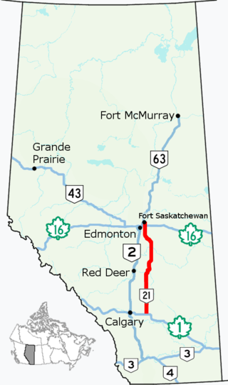
    Alberta Provincial Highway No. 21, commonly referred to as Highway 21, is a north–south highway in Alberta, Canada that parallels Highway 2 between Calgary and Edmonton. It is approximately 328 kilometres (204 mi) in length. It begins at the Trans-Canada Highway (Highway 1) east of Strathmore, and ends at Fort Saskatchewan where it is succeeded by Highway 15. The northernmost 25 kilometres (16 mi) of the highway are twinned. Highway 21 runs roughly parallel to the main north–south CN rail line between Calgary and Edmonton between Three Hills and Looma.

    <span class="mw-page-title-main">Alberta Highway 14</span> Highway in Alberta

    Alberta Provincial Highway No. 14, commonly referred to as Highway 14, is an east-west highway in central Alberta, Canada. It stretches from Edmonton through Wainwright to the Alberta–Saskatchewan border, running parallel to the more northern Highway 16. Highway 14 is about 257 kilometres (160 mi) long.

    <span class="mw-page-title-main">Alberta Highway 13</span> Highway in Alberta

    Alberta Provincial Highway No. 13, commonly referred to as Highway 13, is an east–west highway through central Alberta. It runs from Alder Flats, 7 km (4 mi) west of Highway 22, to the Alberta-Saskatchewan border, where it becomes Saskatchewan Highway 14. Highway 13 is about 366 kilometres (227 mi) long. East of the City of Wetaskiwin, it generally parallels a Canadian Pacific Kansas City rail line.

    <span class="mw-page-title-main">Alberta Highway 18</span> Highway in Alberta, Canada

    Alberta Provincial Highway No. 18, commonly referred to as Highway 18, is a 161-kilometre (100 mi) highway in Alberta, Canada. It stretches from Highway 43 at the hamlet of Green Court, through the towns of Barrhead and Westlock, to Highway 63 east of the hamlet of Thorhild.

    <span class="mw-page-title-main">Alberta Highway 19</span> Highway in Alberta, Canada

    Highway 19 and Highway 625 are two provincial highways south of Edmonton in the Canadian province of Alberta that form a continuous east–west route connecting Highway 60 near Devon to Highway 21 east of Beaumont. Highway 19 was acquired by the City of Edmonton in the land annexation approved by the Province in 2019. Highway 19 passes north of the Edmonton International Airport and, in tandem with Highway 60, provides a southwest bypass of Edmonton between Highways 2 and 16. East of Highway 2, Highway 19 becomes Highway 625 and continues through Nisku Industrial Park. It intersects Highway 814 in Beaumont before ending at Highway 21.

    <span class="mw-page-title-main">Alberta Highway 28</span> Highway in Alberta

    Alberta Provincial Highway No. 28, commonly referred to as Highway 28, is a highway in north-central Alberta, Canada that connects Edmonton to Cold Lake. It begins at Yellowhead Trail (Highway 16) in Edmonton as 97 Street NW, running through the city's north suburbs before entering Sturgeon County and passing CFB Edmonton. After merging with Highway 28A near Gibbons it winds through agricultural lands of north-central Alberta, roughly paralleling the North Saskatchewan River until Smoky Lake before continuing east through St. Paul County to Bonnyville. It turns northeast to CFB Cold Lake, before ending at Lakeshore Drive in the city of Cold Lake shortly thereafter.

    <span class="mw-page-title-main">Alberta Highway 33</span>

    Alberta Provincial Highway No. 33, commonly referred to as Highway 33 and officially named Grizzly Trail, is a north–south highway in west–central Alberta, Canada.

    <span class="mw-page-title-main">Alberta Highway 39</span> Highway in Alberta

    Alberta Provincial Highway No. 39, commonly referred to as Highway 39, is an east–west highway in central Alberta, Canada. It extends from Highway 22, approximately 13 kilometres (8 mi) east of Drayton Valley, to Leduc where it ends at Highway 2. Highway 39 is about 91 kilometres (57 mi) long.

    <span class="mw-page-title-main">Alberta Highway 43</span> Highway in Alberta

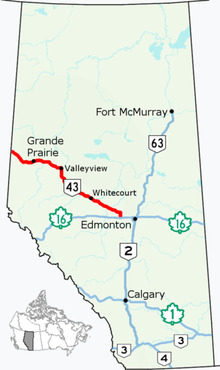
    Alberta Provincial Highway No. 43, commonly referred to as Highway 43, is a major highway in northern and central Alberta, Canada that connects Edmonton to the British Columbia border via the Peace Country, forming the northernmost portion of the CANAMEX Corridor in Alberta. It stretches approximately 495 km (308 mi) from Highway 16 near Manly Corner west of Edmonton to the British Columbia border west of Demmitt. It is designated as a core route in Canada's National Highway System, comprising a portion of a key international corridor that stretches from Alaska into Mexico.

    <span class="mw-page-title-main">Alberta Highway 55</span> Highway in Alberta

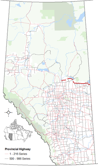
    Alberta Provincial Highway No. 55, commonly referred to as Highway 55, is a 263-kilometre (163 mi) long east–west highway in northeast Alberta, Canada. It extends from the Saskatchewan border in the east through the Cold Lake, Lac La Biche, and Athabasca where it ends at Highway 2. In Saskatchewan, it continues as Saskatchewan Highway 55.

    <span class="mw-page-title-main">Alberta Highway 630</span> Highway in Alberta

    Wye Road is a major arterial road and rural highway that links Sherwood Park from Anthony Henday Drive on the east side of Edmonton to Highway 14 west of Tofield. It is preceded by Sherwood Park Freeway, and east of Highway 21 is designated as Alberta Provincial Highway No. 630, commonly referred to as Highway 630. Wye Road is part of a 40-kilometre-long (25 mi) continuous roadway that runs through Sherwood Park, Edmonton, and St. Albert that includes Sherwood Park Freeway, Whyte Avenue, portions of University Avenue and Saskatchewan Drive, Groat Road, and St. Albert Trail.

    <span class="mw-page-title-main">Alberta Highway 628</span> Highway in Alberta

    Alberta Provincial Highway No. 628, commonly referred to as Highway 628, is a highway in the province of Alberta, Canada, that runs west to east through the Edmonton Capital Region in two sections. The western 19-kilometre-long (12 mi) section runs from the town of Stony Plain to the Edmonton city limits at 231 Street. The eastern 6-kilometre-long (4 mi) section, also known as a Whitemud Extension, runs from Anthony Henday Drive to Highway 21 and it is just at the south of Sherwood Park.

    Alberta Provincial Highway No. 14X, commonly referred to as Highway 14X, was the designation of a former spur route of Highway 14 in Alberta, Canada. It was a short north-south provincial highway located in Strathcona County between Edmonton and Sherwood Park and is now part of Anthony Henday Drive (Highway 216).

    Alberta Provincial Highway No. 550, commonly referred to as Highway 550, is an east–west highway in southern Alberta, Canada. It is a two-lane undivided highway in the County of Newell runs from the Trans-Canada Highway (Highway 1), 5 km (3 mi) southeast of the Town of Bassano, through the Village of Rosemary, to Highway 873 in Duchess. Township Road 212 functions as a western extension of Highway 550 and connects to Bassano.

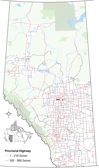
    Alberta Provincial Highway No. 595, also known as Highway 595, is a short highway in the province of Alberta, Canada. It runs west–east from Gaetz Avenue (Highway 2A) along 19 Street, along the southern edge of the Red Deer River valley, to Highway 21 approximately five kilometres (3 mi) north of the village of Delburne. It is also known as Delburne Road and "The Coal Trail" deriving from the route being used to access the Coal mines near Delburne from Red Deer in the early 1900s and is about 38 kilometres (24 mi) long.

    Alberta Provincial Highway No. 873, commonly referred to as Highway 873, is a highway in southern Alberta, Canada. It generally runs north-south from Range Road 162 near the Hamlet of Rainier, through the City of Brooks to Highway 550 in Village of Duchess.

    Alberta Provincial Highway No. 16X, commonly referred to as Highway 16X, is the designation of one former and three proposed routes off Highway 16 in Alberta, Canada. The former section was a 36 km (22 mi) east–west provincial highway in Edmonton Capital Region, that existed for approximately 20 years between the 1970s and 1997 and is now part of Highway 16. Right of way is set aside around Hinton, Edson, and Lloydminster that is presently designated as Highway 16X.

    Alberta Provincial Highway No. 57, commonly referred to as Highway 57, was a highway in central Alberta, Canada that served the Town of Drayton Valley and existed between the 1950s and 1979. It is now part of Highway 22 and Highway 39.

    References

    1. "Transportation Annual Report 2021-2022" (PDF). Alberta Transportation. Retrieved January 3, 2023.
    2. 1 2 Zdeb, Chris (February 22, 2014). "Feb. 22, 1928: Gravel road from Edmonton to U.S. border to be completed in a few months". Edmonton Journal . Postmedia Network Inc. Archived from the original on March 6, 2014. Retrieved February 23, 2014.
    3. "Alberta 1972 Road Map". Surveys Branch, Department of Highways and Transport. 1972.{{cite web}}: Missing or empty |url= (help)
    4. "Alberta 1973 Road Map". Surveys Branch, Department of Highways and Transport. 1973.{{cite web}}: Missing or empty |url= (help)
    5. "Alberta 1974 Road Map". Surveys Branch, Department of Highways and Transport. 1974.{{cite web}}: Missing or empty |url= (help)
    6. "Alberta Road Map" (1990 ed.). Alberta Tourism. 1990.{{cite web}}: Missing or empty |url= (help)
    7. "Provincial Highway Service Classification – Final Report" (PDF). Alberta Transportation. November 2007. p. 1.5. Retrieved October 24, 2016. It is noted that secondary highways ceased to exist by late 2000 and most were re-designated as primary highways.
    8. "Primary Highways 1 - 216 Progress Chart" (2006 ed.). Alberta Transportation. March 2006.{{cite web}}: Missing or empty |url= (help)
    9. "Primary Highways 500 - 986 Progress Chart" (2006 ed.). Alberta Transportation. March 2006.{{cite web}}: Missing or empty |url= (help)
    10. "Provincial Highways 1 - 216 Progress Chart" (2010 ed.). Alberta Transportation. March 2010.{{cite web}}: Missing or empty |url= (help)
    11. "Provincial Highways 500 - 986 Progress Chart" (2010 ed.). Alberta Transportation. March 2010.{{cite web}}: Missing or empty |url= (help)
    12. 1 2 Canada's National Highway System: Annual Report 2015 (PDF) (Report). Council of Ministers Responsible for Transportation and Highway Safety. September 2016. p. 29. Archived from the original (PDF) on November 6, 2016. Retrieved October 30, 2016.
    13. 1 2 3 4 5 6 7 8 9 10 11 12 13 14 Provincial Highway 1-216 Progress Chart (PDF) (Map). Alberta Transportation. March 2017.
    14. 1 2 Rand McNally (1940). Road map of Western and Central Canada (Map). Rand McNally and Company.
    15. The H.M. Gousha Company (1951). "Southern Alberta" (Map). Shell Map of Montana. The Shell Oil Company. §§ H-6, H-7.
    16. The H.M. Gousha Company (1956). "British Columbia - Alberta" (Map). Shell Map of British Columbia, Alberta, Saskatchewan, and Manitoba. The Shell Oil Company. § E-11, F-11.
    17. 1 2 The H.M. Gousha Company (1956). Shell Map of British Columbia, Alberta, Saskatchewan, and Manitoba (Map). The Shell Oil Company. §§ D-10, D-11, E-11, E-12.
    18. 1 2 3 "Primary Highway renumbering to take place in the Peace Region". Government of Alberta. February 24, 1998. Retrieved November 3, 2009.
    19. Province of Alberta Canada Official Road Map (Map). Alberta Tourism and Small Business. 1996. § M-5.
    20. The H.M. Gousha Company (1997). Province of Alberta Canada Official Road Map (Map). § M-5.
    21. 1 2 3 4 The H.M. Gousha Company (1999). Province of Alberta Canada Official Road Map (Map). Edmonton inset.
    22. 1 2 3 Province of Alberta Canada Official Road Map (Map). Alberta Tourism and Small Business. 1996. Edmonton inset.
    23. 1 2 3 "Highways 16 and 16X Renumbered to Provide Greater Consistency". Government of Alberta. June 4, 1997. Retrieved September 10, 2009.[ permanent dead link ]
    24. Alberta Canada Official Road Map 1942 (Map). Department of Public Works. § D-7, E-7.
    25. Alberta Canada Official Road Map 1946 (Map). Department of Public Works. § D-7, E-7.
    26. "Annual Road Closures". Alberta Parks. Retrieved February 14, 2017.
    27. Province of Alberta Canada Official Road Map 1971 (Map). Government of the Province of Alberta. § O-6.
    28. Province of Alberta Canada Official Road Map 1972 (Map). Government of the Province of Alberta. § O-6.
    29. Province of Alberta Canada Official Road Map 1976/77 (Map). Alberta Business Development and Tourism. § H-6, H-7, I-6.
    30. Province of Alberta Canada Official Road Map 1978/79 (Map). Alberta Business Development and Tourism. § H-6, H-7, I-6.
    31. Travel Alberta (1978). Alberta Official Road Map (Map) (1978–79 ed.). Province of Alberta. §§ N-8, O-8.
    32. Travel Alberta (1980). Alberta Official Road Map (Map) (1978–79 ed.). Province of Alberta. §§ N-8, O-8.
    33. Travel Alberta (1984). Alberta Official Road Map (Map). The Province of Alberta. § K-5.
    34. Travel Alberta (1988). Alberta Official Road Map (Map). The Province of Alberta. § K-5.
    35. Travel Alberta (1978–79). Alberta Official Road Map (Map). The Province of Alberta. §§ J-5, I-5.
    36. Travel Alberta (1980). Alberta Official Road Map (Map). The Province of Alberta. §§ J-5, I-5.
    37. Aimee Harper (January 30, 2014). "Province, municipality sign off on land-road deal". Fort McMurray Today . Sun Media Community Newspapers. Archived from the original on May 12, 2016. Retrieved July 16, 2016.
    38. Travel Alberta (1980–81). Alberta Official Road Map (Map). The Province of Alberta. § H-8.
    39. Travel Alberta (1982). Alberta Official Road Map (Map). The Province of Alberta. § H-8.
    40. Province of Alberta Canada 1985 Official Road Map (Map). Alberta Tourism and Small Business. § H-8.
    41. Province of Alberta Canada 1986 Official Road Map (Map). Alberta Tourism and Small Business. § H-8.
    42. 1 2 "HIGHWAYS 2 and 3 Fort Macleod Bypass Functional Planning Study" (PDF). Government of Alberta. July 3, 2008. pp. 21–22. Retrieved June 21, 2018.
    43. "Alberta Infrastructure Requests for Proposals Short List of Firms and Selection Results" (PDF). Alberta Transportation. February 8, 2001. p. 14. Archived from the original (PDF) on March 8, 2017. Retrieved March 8, 2017.
    44. 1 2 "Executive Summary: Highway 3/6 Interchange Functional Planning Study" (PDF). Alberta Transportation. Government of Alberta. April 2008. pp. ES-5, ES-6. Retrieved June 26, 2018.
    45. Travel Alberta (1992). Alberta Official Road Map (Map). The Province of Alberta. § O-8.
    46. Travel Alberta (1995). Alberta Official Road Map (Map). The Province of Alberta. § O-8.
    47. Travel Alberta (1978–79). Alberta Official Road Map (Map). The Province of Alberta. §§ N-5, N-6.
    48. Travel Alberta (1980). Alberta Official Road Map (Map). The Province of Alberta. §§ N-5, N-6.
    49. Travel Alberta (1974). Alberta Official Road Map (Map). The Province of Alberta. § M-5.
    50. Travel Alberta (1975). Alberta Official Road Map (Map). The Province of Alberta. § M-5.
    51. Travel Alberta (1983). Alberta Official Road Map (Map). The Province of Alberta. § M-5.
    52. 1 2 Travel Alberta (1978–79). Alberta Official Road Map (Map). The Province of Alberta. § M-5.
    53. 1 2 Travel Alberta (1980). Alberta Official Road Map (Map). The Province of Alberta. § M-5.
    54. Travel Alberta (1978–79). Alberta Official Road Map (Map). The Province of Alberta. §§ L-5, L-6.
    55. Travel Alberta (1980). Alberta Official Road Map (Map). The Province of Alberta. §§ L-5, L-6.
    56. 1 2 Travel Alberta (1978–79). Alberta Official Road Map (Map). The Province of Alberta. § J-5.
    57. 1 2 Travel Alberta (1980). Alberta Official Road Map (Map). The Province of Alberta. § J-5.
    58. "Media Release" (PDF). Beaver County. June 2, 2009. Retrieved September 14, 2009.[ permanent dead link ]
    59. 1 2 Travel Alberta (1978–79). Alberta Official Road Map (Map). The Province of Alberta. § I-5.
    60. Travel Alberta (1980). Alberta Official Road Map (Map). The Province of Alberta. § I-5.
    61. Travel Alberta (1984). Alberta Official Road Map (Map). The Province of Alberta. §§ I-5, I-6.
    62. Travel Alberta (1988). Alberta Official Road Map (Map). The Province of Alberta. §§ I-5, I-6.
    63. "Travel to St. Paul made easier with new Highway 29 designation". Government of Alberta. October 10, 2006. Retrieved November 3, 2009.
    64. Travel Alberta (1976). Alberta Official Road Map (Map). The Province of Alberta. § I-5.
    65. 1 2 Travel Alberta (1976). Alberta Official Road Map (Map). The Province of Alberta. §§ H-6, H-7, H-8.
    66. 1 2 Travel Alberta (1978–79). Alberta Official Road Map (Map). The Province of Alberta. §§ H-6, H-7, H-8.
    67. Travel Alberta (1994). Alberta Official Road Map (Map). The Province of Alberta. §§ F-3, F-4.
    68. Travel Alberta (1995). Alberta Official Road Map (Map). The Province of Alberta. §§ F-3, F-4.
    69. "Highway 742" (Map). Town of Canmore. Retrieved June 5, 2018.
    70. "Weberville Area Concept Plan" (PDF). County of Northern Lights. ISL Engineering and Land Services. November 2010. p. 2 (pdf 7). Retrieved December 16, 2021. Highway 743 (Weberville Road)
    71. Travel Alberta (1978–79). Alberta Official Road Map (Map). The Province of Alberta. § I-4.
    72. Travel Alberta (1980). Alberta Official Road Map (Map). The Province of Alberta. § I-4.
    73. "Transportation Infrastructure Management System - Existing Structures in the Provincial Highway Corridor" (PDF). Alberta Transportation. September 28, 2012. p. 89. Retrieved June 6, 2018.
    74. "Secondary Hwy 794 status changed". Government of Alberta. September 15, 1999. Retrieved September 10, 2009.
    75. Travel Alberta (1988). Alberta Official Road Map (Map). The Province of Alberta. § H-7.
    76. Travel Alberta (1990). Alberta Official Road Map (Map). The Province of Alberta. § H-7.
    77. Travel Alberta (1978–79). Alberta Official Road Map (Map). The Province of Alberta. §§ M-5, M-6.
    78. Travel Alberta (1980). Alberta Official Road Map (Map). The Province of Alberta. § M-5, M-6.
    79. Travel Alberta (1984). Alberta Official Road Map (Map). The Province of Alberta. §§ M-5, M-6.
    80. Travel Alberta (1988). Alberta Official Road Map (Map). The Province of Alberta. § M-5, M-6.
    81. 1 2 Provincial Highway 500-986 Progress Chart (PDF) (Map). Alberta Transportation. March 2017.
    82. 1 2 "Provincial Highway Service Classification – Final Report, November 2007" (PDF). Alberta Transportation. November 27, 2007. Retrieved February 28, 2011.
    83. 1 2 "2010 PMS Highway Summary Report, Data Year 2009" (PDF). Alberta Transportation. May 12, 2010. Retrieved February 28, 2011.