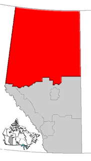
Division No. 18 is a census division in Alberta, Canada. It is located in the southeast corner of northern Alberta and its largest urban community is the Town of Grande Cache. The boundaries of the division are coextensive with the outer boundaries of the Municipal District of Greenview No. 16.

Grande Cache is a hamlet within and administered by the Municipal District of Greenview No. 16 in west-central Alberta, Canada. It is located on Highway 40 approximately 145 kilometres (90 mi) northwest of Hinton and 435 kilometres (270 mi) west of Edmonton. Grande Cache overlooks the Smoky River, is at the northern edge of Alberta's Rockies, and serves as the gateway to the Willmore Wilderness Park. The hamlet held town status prior to 2019.

Greenview is a residential neighbourhood in the northeast quadrant of Calgary, Alberta. It is bounded to the north by 64 Avenue N, to the east by Deerfoot Trail, to the south by McKnight Boulevard and Edmonton Trail and to the west by 14 Street W.

Greenview is a residential neighbourhood in the Mill Woods area of southeast Edmonton, Alberta, Canada. It is located to the south of the Mill Woods Golf Course.

DeBolt is a hamlet in northern Alberta, Canada within the Municipal District of Greenview No. 16. A variant name is Debolt. H. E. Debolt, an early postmaster, gave the community his last name.

Barycz is a village in the administrative district of Gmina Stubno, within Przemyśl County, Subcarpathian Voivodeship, in south-eastern Poland, close to the border with Ukraine. It lies approximately 5 kilometres (3 mi) west of Stubno, 16 km (10 mi) north-east of Przemyśl, and 66 km (41 mi) east of the regional capital Rzeszów.
Wola Chynowska is a village in the administrative district of Gmina Chynów, within Grójec County, Masovian Voivodeship, in east-central Poland. It lies approximately 1 kilometre (1 mi) south of Chynów, 16 km (10 mi) east of Grójec, and 36 km (22 mi) south of Warsaw.
Little Smoky is a hamlet in northwest Alberta, Canada within the Municipal District of Greenview No. 16. It is located on Highway 43, approximately 39 kilometres (24 mi) south of Valleyview and 47 kilometres (29 mi) northwest of Fox Creek. The hamlet is adjacent to the Little Smoky River.
Lubiń is a village in the administrative district of Gmina Krzywiń, within Kościan County, Greater Poland Voivodeship, in west-central Poland. It lies approximately 6 kilometres (4 mi) east of Krzywiń, 22 km (14 mi) south-east of Kościan, and 49 km (30 mi) south of the regional capital Poznań.
Beaver Lake is a hamlet in northern Alberta, Canada within Lac La Biche County. It is located on the shore of Beaver Lake, 4 kilometres (2.5 mi) east of Highway 55, approximately 116 kilometres (72 mi) northwest of Cold Lake.
Calais is an unincorporated community in northern Alberta, on the south shore of Sturgeon Lake, surrounded by the Sturgeon Lake Cree Nation in the Municipal District of Greenview No. 16. It is located 0.5 kilometres (0.31 mi) north of Highway 43, 83 kilometres (52 mi) east of Grande Prairie.
Canyon Creek is a hamlet in northern Alberta, Canada within the Municipal District of Lesser Slave River No. 124. It is located on Highway 2, approximately 234 kilometres (145 mi) east of Grande Prairie.
Landry Heights is a hamlet in northern Alberta, Canada within the Municipal District of Greenview No. 16. It is located approximately 11 kilometres (6.8 mi) west of Highway 40 and 16 kilometres (9.9 mi) southwest of Grande Prairie.
New Fish Creek is an unincorporated community in northern Alberta within the Municipal District of Greenview No. 16, located 3 kilometres (1.9 mi) west of Highway 49, 98 kilometres (61 mi) northeast of Grande Prairie.
Reno is a hamlet in northern Alberta, Canada within Northern Sunrise County. It is located 8 kilometres (5.0 mi) east of Highway 2, approximately 146 kilometres (91 mi) northeast of Grande Prairie. It is probably named after Reno, Nevada.
Ridgevalley is a hamlet in northern Alberta, Canada within the Municipal District of Greenview No. 16. It is located 2.5 kilometres (1.6 mi) southwest of Highway 43, approximately 57 kilometres (35 mi) east of Grande Prairie.
Sturgeon Heights is a settlement in northern Alberta within the Municipal District of Greenview No. 16, located on Highway 43, 71 kilometres (44 mi) southeast of Grande Prairie.
Sturgeon Lake 154 is an Indian reserve in northern Alberta, Canada. It is located on Highway 43, 3.5 km (2.2 mi) west of the Town of Valleyview and approximately 85 km (53 mi) east of the City of Grande Prairie. It and the adjacent Sturgeon Lake 154B Indian Reserve are surrounded by the Municipal District of Greenview No. 16. It is under the administration of the Sturgeon Lake Cree Nation.
Muskeg River is a settlement in northern Alberta, Canada within the Municipal District of Greenview No. 16.