
Division No. 11 is a census division in Alberta, Canada. Surrounding the City of Edmonton, the majority of the division comprises Alberta's Capital Region, while the western and southern portions of the division are located within central Alberta. The division also forms the northern segment of the Calgary–Edmonton Corridor.
Division No. 12 is a census division in Alberta, Canada. Including the City of Cold Lake, the majority of the division is located in the northeast corner of central Alberta, while the northern portion of the division is located within northern Alberta.
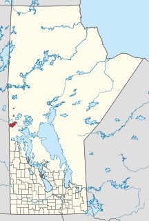
Division No. 17 is a census division in Alberta, Canada. It spans the central and northwest portions of northern Alberta and its largest urban community is the Town of Slave Lake. Division No. 17 is the largest census division in Alberta according to area and also has the lowest population density.

South Cooking Lake is a hamlet in Alberta, Canada within Strathcona County. It is located on Highway 14, approximately 19 km (12 mi) southeast of Sherwood Park.

Frog Lake is a Cree community approximately 207 km (129 mi) east of Edmonton, Alberta, Canada. It is located 11 km (6.8 mi) northeast of the Hamlet of Heinsburg and 13 km (8.1 mi) southwest of the Fishing Lake Metis Settlement.

Utikuma Lake is a large lake in north-central Alberta, Canada. It is located 30 km (19 mi) north of the Lesser Slave Lake, between the Bicentennial Highway and Highway 750.
Cadotte Lake is an unincorporated community in northern Alberta, Canada within Northern Sunrise County. It is located on the northern shore of the homonymous lake, along Highway 986, 79 km (49 mi) east of Peace River and 68 km (42 mi) west of the Bicentennial Highway.

Samson Indian Reserve No. 137, also known as Samson No. 137 and Samson 137, and as the Samson Reserve, is an Indian reserve in Maskwacis, Alberta, Canada.
Kelsey is a rural municipality in the province of Manitoba in Western Canada. It consists of several disjoint parts. The largest part is Carrot Valley, located around and southwest of The Pas along the Carrot River, but the communities of Wanless and Cranberry Portage, located further north, are also part of the municipality. It is 867.64 km² large. Also lying in the area around The Pas is the Opaskwayak Cree Nation Indian reserve.

The Onion Lake Cree Nation is a Plains Cree First Nations band government in Canada, straddling the Alberta/Saskatchewan provincial border approximately 50 km (31 mi) north of the City of Lloydminster.
Brosseau is a hamlet in central Alberta, Canada within the County of Two Hills No. 21. It is located on the north bank of the North Saskatchewan River along the Highway 29 / Highway 36 concurrency, 50 km (31 mi) southwest of St. Paul. The hamlet of Duvernay is located immediately across the river along the south bank.
Brownvale is a hamlet in northern Alberta, Canada within the Municipal District of Peace No. 135. It is located on Highway 737 less than 1 kilometre (0.62 mi) off Highway 2, approximately 48 kilometres (30 mi) southwest of the Town of Peace River and 20 kilometres (12 mi) southwest of Grimshaw. Duncan's First Nation reserve is less than 5 km (3.1 mi) to the south.
Hamlin is an unincorporated community in central Alberta in Smoky Lake County, located 15 kilometres (9.3 mi) south of Highway 28, 125 kilometres (78 mi) southwest of Cold Lake.
Ranfurly is a hamlet in central Alberta, Canada within the County of Minburn No. 27. Previously an incorporated municipality, Ranfurly dissolved from village status on January 1, 1946 to become part of the Municipal District of Birch Lake No. 484.

Saddle Lake 125 is an Indian reserve of the Saddle Lake Cree Nation in Alberta, located between Smoky Lake County and the County of St. Paul No. 19. It is 24 kilometres west of St. Paul.
Puskiakiwenin 122 is an Indian reserve in Alberta. It is located 59 kilometres (37 mi) southwest of Cold Lake. It is at an elevation of 612 metres (2,008 ft). It belongs to the Frog Lake First Nation, a Cree nation.
Sturgeon Lake 154 is an Indian reserve in northern Alberta, Canada. It is located on Highway 43, 3.5 km (2.2 mi) west of the Town of Valleyview and approximately 85 km (53 mi) east of the City of Grande Prairie. It and the adjacent Sturgeon Lake 154B Indian Reserve are surrounded by the Municipal District of Greenview No. 16. It is under the administration of the Sturgeon Lake Cree Nation.

Blue Quills First Nation is an Indian reserve shared by the Beaver Lake Cree, Cold Lake, Frog Lake, Heart Lake, Kehewin Cree, and Saddle Lake Cree First Nations in Alberta, located within the County of St. Paul No. 19. It is 3 kilometers west of St. Paul.

Whitefish Lake 128 is an Indian reserve of the Saddle Lake Cree Nation in Alberta, located between Smoky Lake County and the County of St. Paul No. 19. It is 68 kilometres west of Bonnyville. In the 2016 Canadian Census, it recorded a population of 1310 living in 291 of its 319 total private dwellings.


