Alexander 134A

Last updated
Alexander 134A
Alexander Indian Reserve No. 134A
CAN AB 1074 ALEXANDER INDIAN RESERVE -134A MAP.svg
Boundaries of Alexander 134A
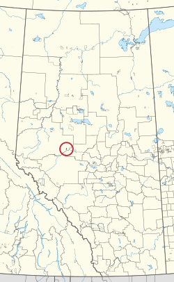
CAN AB 255 ALEXANDER INDIAN RESERVE -134A.svg
Location in Alberta
First Nation Alexander
Treaty 8
CountryCanada
Province Alberta
Municipal district Greenview
Area
[1]
  Total2,303.5 ha (5,692.1 acres)

Alexander 134A is an Indian reserve of the Alexander First Nation in Alberta. Located within the Municipal District of Greenview No. 16, [2] it is 25 kilometres southeast of Fox Creek. [1]

Related Research Articles

<span class="mw-page-title-main">Alexis Elk River 233</span> Indian reserve in Alexis Nakota Sioux

Alexis Elk River 233 is an Indian reserve of the Alexis Nakota Sioux Nation in Alberta, located within Yellowhead County. It is 87 kilometers southeast of Hinton.

<span class="mw-page-title-main">Boyer 164</span> Indian reserve in Beaver

Boyer River 164 is an Indian reserve of the Beaver First Nation in Alberta, located within Mackenzie County. It is 16 kilometers northwest of Fort Vermilion. In the 2016 Canadian Census, it recorded a population of 218 living in 63 of its 67 total private dwellings.

<span class="mw-page-title-main">Bushe River 207</span> Indian reserve in Dene Tha

Bushe River 207 is an Indian reserve of the Dene Tha' First Nation in Alberta, located within Mackenzie County. To the west, it is adjacent to the town of High Level. In the 2016 Canadian Census, it recorded a population of 503 living in 134 of its 142 total private dwellings.

<span class="mw-page-title-main">Child Lake 164A</span> Indian reserve in Beaver

Child Lake 164A is an Indian reserve of the Beaver First Nation in Alberta, located within Mackenzie County. It is 32 kilometers northwest of Fort Vermilion. The reserve takes its name from a nearby lake where a child once drowned.

<span class="mw-page-title-main">Cold Lake 149</span> Indian reserve in Cold Lake

Cold Lake 149 is an Indian reserve of the Cold Lake First Nations in Alberta, located within the Municipal District of Bonnyville No. 87. It is 26 kilometers east of Bonnyville. In the 2016 Canadian Census, it recorded a population of 671 living in 208 of its 222 total private dwellings.

Alexander First Nation is a First Nations band government, headquartered 17 kilometres (11 mi) west of Morinville, Alberta. This First Nation is part of the Cree ethno-linguistic group, is a member of the Yellowhead Tribal Council, and is party to Treaty 6. The band controls three Indian reserves: Alexander 134, Alexander 134A, and Alexander 134B. The main reserve is bordered by Sturgeon County and Lac Ste. Anne County.

<span class="mw-page-title-main">Kapawe'no 150B</span> Indian reserve in Kapaweno

Kapawe'no 150B, historically known as Freeman 150B, is an Indian reserve of the Kapawe'no First Nation in Alberta, located within Big Lakes County. It is 8 kilometers northwest of Lesser Slave Lake. In the 2016 Canadian Census, it recorded a population of 154 living in of its 45 total private dwellings.

<span class="mw-page-title-main">Sucker Creek 150A</span> Indian reserve in Sucker Creek

Sucker Creek 150A is an Indian reserve of the Sucker Creek First Nation in Alberta, located within Big Lakes County. It is 22 kilometres south of High Prairie. In the 2016 Canadian Census, it recorded a population of 689 living in 235 of its 274 total private dwellings.

<span class="mw-page-title-main">Alexander 134B</span> Indian reserve in Alexander

Alexander 134B is an Indian reserve of the Alexander First Nation in Alberta, within Woodlands County. It is 36 kilometres northwest of Barrhead.

<span class="mw-page-title-main">Cold Lake 149A</span> Indian reserve in Cold Lake

Cold Lake 149A is an Indian reserve of the Cold Lake First Nations in Alberta, located within the Municipal District of Bonnyville No. 87. It is on the south shore of Cold Lake, immediately adjacent to the city of Cold Lake.

<span class="mw-page-title-main">Cold Lake 149B</span> Indian reserve in Cold Lake

Cold Lake 149B is an Indian reserve of the Cold Lake First Nations in Alberta, located within the Municipal District of Bonnyville No. 87. It is south of the Beaver River, a short distance northwest of the city of Cold Lake.

<span class="mw-page-title-main">Cold Lake 149C</span> Indian reserve in Cold Lake

Cold Lake 149C is an Indian reserve of the Cold Lake First Nations in Alberta, located within the Municipal District of Bonnyville No. 87.

<span class="mw-page-title-main">Kapawe'no 150C</span> Indian reserve in Kapaweno

Kapawe'no 150C, formerly known as Halcro 150C, is an Indian reserve of the Kapawe'no First Nation in Alberta, located within Big Lakes County. It is 17 kilometres northeast of High Prairie.

<span class="mw-page-title-main">Kapawe'no 150D</span> Indian reserve in Kapaweno

Kapawe'no 150D, formerly known as Pakashan 150D, is an Indian reserve of the Kapawe'no First Nation in Alberta, located within Big Lakes County. It is 13 kilometres northwest of Lesser Slave Lake. In the 2016 Canadian Census, it recorded a population of 5 living in 4 of its 7 total private dwellings.

<span class="mw-page-title-main">Kapawe'no 229</span> Indian reserve in Kapaweno

Kapawe'no 229 is an Indian reserve of the Kapawe'no First Nation in Alberta, located within Big Lakes County. It is 27 kilometres northeast of High Prairie.

<span class="mw-page-title-main">Kapawe'no 230</span> Indian reserve in Kapaweno

Kapawe'no 230 is an Indian reserve of the Kapawe'no First Nation in Alberta, located within Big Lakes County. It is 25 kilometres northeast of High Prairie.

<span class="mw-page-title-main">William McKenzie 151K</span> Indian reserve in Duncans

William McKenzie 151K is an Indian reserve of the Duncan's First Nation in Alberta, located within Northern Sunrise County. It is 33 kilometres north of McLennan.

<span class="mw-page-title-main">Woodland Cree 226</span> Indian reserve in Woodland Cree

Woodland Cree 226 is an Indian reserve of the Woodland Cree First Nation in Alberta, located within Northern Sunrise County. It is 48 kilometres northeast of Peace River. In the 2016 Canadian Census, it recorded a population of 723 living in 188 of its 211 total private dwellings.

<span class="mw-page-title-main">Woodland Cree 227</span> Indian reserve in Woodland Cree

Woodland Cree 227 is an Indian reserve of the Woodland Cree First Nation in Alberta, located within Northern Sunrise County. It is 60 kilometres northeast of Peace River.

<span class="mw-page-title-main">Woodland Cree 228</span> Indian reserve in Woodland Cree

Woodland Cree 228 is an Indian reserve of the Woodland Cree First Nation in Alberta, located within Northern Sunrise County. It is 75 kilometres northeast of Peace River. In the 2016 Canadian Census, it recorded a population of 150 living in 33 of its 36 total private dwellings.

References

  1. 1 2 "Reserve/Settlement/Village Detail". Crown–Indigenous Relations and Northern Affairs Canada . Government of Canada. Retrieved August 12, 2019.
  2. Government of Alberta (2019). Municipal Boundaries (Map). AltaLIS.

54°17′03″N116°26′55″W / 54.284178°N 116.448535°W / 54.284178; -116.448535 (Alexander 134A)