The Piikani Nation is a First Nation, representing the Indigenous people in Canada known as the Northern Piikani or simply the Peigan.
The Skatin First Nations, aka the Skatin Nations, are a band government of the In-SHUCK-ch Nation, a small group of the larger St'at'imc people who are also referred to as Lower Stl'atl'imx. The Town of Skatin - the St'at'imcets version of the Chinook Jargon Skookumchuck- is located 4 km south of T'sek Hot Spring- alt. spelling T'sek Hot Spring - commonly & formerly named both St. Agnes' Well & Skookumchuck Hot Springs The community is 28 km south of the outlet of Lillooet Lake on the east side of the Lillooet River. It is approximately 75 km south of the town of Pemberton and the large reserve of the Lil'wat branch of the St'at'imc at Mount Currie. Other bands nearby are Samahquam at Baptiste Smith IR on the west side of the Lillooet River at 30 km. and Xa'xtsa First Nations; the latter is located at Port Douglas, near the mouth of the Lillooet River where it enters the head of Harrison Lake. The N'Quatqua First Nation on Anderson Lake, between Mount Currie and Lillooet, was at one time involved in joint treaty negotiations with the In-SHUCK-ch but its members have voted to withdraw, though a tribal council including the In-SHUCK-ch bands and N'Quatqua remains, the Lower Stl'atl'imx Tribal Council.

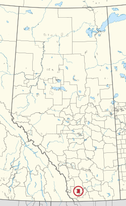
Division No. 3 is a census division in Alberta, Canada. It is located in the southwest corner of southern Alberta and its largest urban community is the Town of Claresholm.
Division No. 17 is a census division in Alberta, Canada. It spans the central and northwest portions of northern Alberta and its largest urban community is the Town of Slave Lake. Division No. 17 is the largest census division in Alberta according to area and also has the lowest population density.
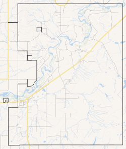
Brocket is a settlement in Peigan 147, in southern Alberta located on Highway 3 between Pincher Creek and Fort Macleod. It is the main community on the Piikani Nation reserve.

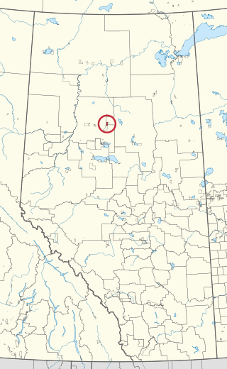
Wabasca 166 is an Indian reserve of the Bigstone Cree Nation in Alberta, located within the Municipal District of Opportunity No. 17. It is 80 kilometres north of Slave Lake. In the 2016 Canadian Census, it recorded a population of 160 living in 42 of its 49 total private dwellings.

Jean Baptiste Gambler 183 is an Indian reserve of the Bigstone Cree Nation in Alberta, located within the Municipal District of Opportunity No. 17. In the 2016 Canadian Census, it recorded a population of 253 living in 68 of its 86 total private dwellings.

Blood 148 is a First Nations reserve in Alberta, Canada. It is inhabited by the Blood (Kainai) First Nation and was established under the provisions of Treaty 7. This reserve is managed from the community of Stand Off on its northwest border and encompasses the majority of lands bounded by the cities of Fort MacLeod, Lethbridge and Cardston. It is traversed by Alberta Highway 2, Highway 5, and Highway 509. The St Mary River and the Belly River are major rivers supplying and draining the lands.

Wabasca 166D is an Indian reserve of the Bigstone Cree Nation in Alberta, located within the Municipal District of Opportunity No. 17. It is 78 kilometres north of Slave Lake. In the 2016 Canadian Census, it recorded a population of 188 living in 47 of its 58 total private dwellings.

Wabasca 166C is an Indian reserve of the Bigstone Cree Nation in Alberta, located within the Municipal District of Opportunity No. 17. In the 2016 Canadian Census, it recorded a population of 188 people living in 47 of its 58 total private dwellings. The community is located along the northeast shore of North Wabasca Lake.
Wabasca 166B is an Indian reserve of the Bigstone Cree Nation in Alberta, located within the Municipal District of Opportunity No. 17. In the 2016 Canadian Census, it recorded a population of 190 living in 43 of its 52 total private dwellings. The community is located on the southern shore of North Wabasca Lake and to the west of the hamlet of Wabasca.

Wabasca 166A is an Indian reserve of the Bigstone Cree Nation in Alberta, located within the Municipal District of Opportunity No. 17. In the 2016 Canadian Census, it recorded a population of 658 living in 183 of its 213 total private dwellings.

Montana 139 is an Indian reserve of the Montana First Nation in Alberta, located within Ponoka County. Part of the Maskwacis community, it is 24 kilometers south of Wetaskiwin. In the 2016 Canadian Census, it recorded a population of 630 living in 137 of its 143 total private dwellings.
The Leq'á:mel First Nation, formerly known as Lakahahmen First Nation, is a First Nations band government whose community and offices are located in the area near Deroche, British Columbia in the Fraser Valley region in Canada, about 12 kilometres east of the District of Mission. They are a member government of the Sto:lo Nation Chiefs Council, which is one of two tribal councils of the Sto:lo.
The Oldman River Dam is a dam on the Oldman River in southwestern Alberta, Canada. The dam is north of Pincher Creek in the Municipal District of Pincher Creek No. 9.

Blood 148A is an Indian reserve of the Kainai Nation in Alberta, located within Improvement District No. 4. It is on the left bank of the Belly River, about 1.5 miles north of the international boundary.
Loon Lake 235 is an Indian reserve of the Loon River First Nation in Alberta, located within Northern Sunrise County and the Municipal District of Opportunity No. 17. It is 5 kilometres southwest of Loon Lake. In the 2016 Canadian Census, it recorded a population of 555 living in 147 of its 157 total private dwellings.

Peigan Timber Limit 147B is an Indian reserve of the Piikani Nation in Alberta, located within the Municipal District of Willow Creek No. 26.