{{Jct|state=AB|Hwy|58}}in [[High Level,Alberta|High Level]]"},"terminus_b":{"wt":"{{Jct|state=NT|Hwy|1}}at the [[Northwest Territories|NWT]] border near [[Indian Cabins,Alberta|Indian Cabins]]"},"rural_municipalities":{"wt":"[[Municipal District of Peace No. 135|Peace No. 135 M.D.]],[[County of Northern Lights|Northern Lights County]],[[Mackenzie County]]"},"towns":{"wt":"[[Manning,Alberta|Manning]],[[High Level,Alberta|High Level]]"},"established":{"wt":""},"previous_type":{"wt":"Hwy"},"previous_route":{"wt":"33"},"next_type":{"wt":"Hwy"},"next_route":{"wt":"36"}},"i":0}}]}" id="mwCQ">.mw-parser-output .header-default,.mw-parser-output .header-UNK,.mw-parser-output .header-ATA,.mw-parser-output .header-BDI,.mw-parser-output .header-CAF,.mw-parser-output .header-COG,.mw-parser-output .header-COM,.mw-parser-output .header-DMA,.mw-parser-output .header-ERI,.mw-parser-output .header-FSM,.mw-parser-output .header-GAB,.mw-parser-output .header-HTI,.mw-parser-output .header-GMB,.mw-parser-output .header-GUY,.mw-parser-output .header-HRV,.mw-parser-output .header-KEN,.mw-parser-output .header-KNA,.mw-parser-output .header-LBY,.mw-parser-output .header-LCA,.mw-parser-output .header-MHL,.mw-parser-output .header-MRT,.mw-parser-output .header-NER,.mw-parser-output .header-NIU,.mw-parser-output .header-NRU,.mw-parser-output .header-SDN,.mw-parser-output .header-SLB,.mw-parser-output .header-SOM,.mw-parser-output .header-SSD,.mw-parser-output .header-TGO,.mw-parser-output .header-TUV,.mw-parser-output .header-UGA,.mw-parser-output .header-VCT{background:#cedff2}.mw-parser-output .header-deleted{background:#ccc}.mw-parser-output .header-hist{background:#704214;color:#fff}.mw-parser-output .header-uc{background:#ffa500}.mw-parser-output .header-autobahn{background:#003abd;color:#fff}.mw-parser-output .header-ASIA{background:#1e2c76;color:#fff}.mw-parser-output .header-ASIA-RUS{background:#00004e;color:#fff}.mw-parser-output .header-EUR{background:#08842C;color:#fff}.mw-parser-output .header-EUR-ESP{background:#13926c;color:#fff}.mw-parser-output .header-EUR-FIN{background:#00997c;color:#fff}.mw-parser-output .header-EUR-FRA{background:#28961e;color:#fff}.mw-parser-output .header-EUR-NOR{background:#00965e;color:#fff}.mw-parser-output .header-EUR-RUS{background:#00a500;color:#fff}.mw-parser-output .header-EUR-UKR{background:#090;color:#fff}.mw-parser-output .header-minor,.mw-parser-output .header-AND,.mw-parser-output .header-AUT,.mw-parser-output .header-BFA,.mw-parser-output .header-CMR,.mw-parser-output .header-CPV,.mw-parser-output .header-DEU,.mw-parser-output .header-DJI,.mw-parser-output .header-DZA,.mw-parser-output .header-ENG,.mw-parser-output .header-FRA,.mw-parser-output .header-FIN,.mw-parser-output .header-GEO,.mw-parser-output .header-GGY,.mw-parser-output .header-GIB,.mw-parser-output .header-GBR,.mw-parser-output .header-GNB,.mw-parser-output .header-GNQ,.mw-parser-output .header-GUF,.mw-parser-output .header-IMN,.mw-parser-output .header-IRL,.mw-parser-output .header-IRN,.mw-parser-output .header-JEY,.mw-parser-output .header-MAR,.mw-parser-output .header-MCO,.mw-parser-output .header-MDV,.mw-parser-output .header-MLI,.mw-parser-output .header-MTQ,.mw-parser-output .header-MYT,.mw-parser-output .header-NIR,.mw-parser-output .header-NPL,.mw-parser-output .header-PRT,.mw-parser-output .header-PSE,.mw-parser-output .header-REU,.mw-parser-output .header-SCT,.mw-parser-output .header-SEN,.mw-parser-output .header-STP,.mw-parser-output .header-TCD,.mw-parser-output .header-TZA,.mw-parser-output .header-WLS{background:#fff;border:2px solid #000}.mw-parser-output .header-motorway,.mw-parser-output .header-ALA,.mw-parser-output .header-AZE,.mw-parser-output .header-CHE,.mw-parser-output .header-EST,.mw-parser-output .header-GIN,.mw-parser-output .header-GRC,.mw-parser-output .header-JOR,.mw-parser-output .header-LAO,.mw-parser-output .header-LBN,.mw-parser-output .header-LIE,.mw-parser-output .header-MLT,.mw-parser-output .header-MNG,.mw-parser-output .header-MYS,.mw-parser-output .header-NLD,.mw-parser-output .header-OMN,.mw-parser-output .header-ROU,.mw-parser-output .header-SUR,.mw-parser-output .header-SVK,.mw-parser-output .header-SYR,.mw-parser-output .header-TTO,.mw-parser-output .header-YEM{background:#0079C1;color:#fff}.mw-parser-output .header-MUTCDblue,.mw-parser-output .header-AFG,.mw-parser-output .header-BGR,.mw-parser-output .header-CZE,.mw-parser-output .header-CYP,.mw-parser-output .header-EGY,.mw-parser-output .header-ITA,.mw-parser-output .header-PAK,.mw-parser-output .header-SMR,.mw-parser-output .header-SVK,.mw-parser-output .header-SWE{background:#003f87;color:#fff}.mw-parser-output .header-MUTCDgreen,.mw-parser-output .header-ANG,.mw-parser-output .header-ARE,.mw-parser-output .header-ARG,.mw-parser-output .header-BEL,.mw-parser-output .header-BHN,.mw-parser-output .header-BEN,.mw-parser-output .header-BLZ,.mw-parser-output .header-BOL,.mw-parser-output .header-BRA,.mw-parser-output .header-BRN,.mw-parser-output .header-BWA,.mw-parser-output .header-CAN,.mw-parser-output .header-CHL,.mw-parser-output .header-CHN,.mw-parser-output .header-COL,.mw-parser-output .header-CRI,.mw-parser-output .header-CRI,.mw-parser-output .header-CUB,.mw-parser-output .header-DOM,.mw-parser-output .header-ECU,.mw-parser-output .header-ETH,.mw-parser-output .header-FJI,.mw-parser-output .header-GHA,.mw-parser-output .header-GRD,.mw-parser-output .header-GTM,.mw-parser-output .header-HKG,.mw-parser-output .header-HND,.mw-parser-output .header-HUN,.mw-parser-output .header-IDN,.mw-parser-output .header-IRQ,.mw-parser-output .header-KIR,.mw-parser-output .header-KHM,.mw-parser-output .header-KOR,.mw-parser-output .header-KWT,.mw-parser-output .header-LBR,.mw-parser-output .header-LKA,.mw-parser-output .header-LSO,.mw-parser-output .header-MEX,.mw-parser-output .header-MMR,.mw-parser-output .header-MOZ,.mw-parser-output .header-MUS,.mw-parser-output .header-NAM,.mw-parser-output .header-NGA,.mw-parser-output .header-NIC,.mw-parser-output .header-NZL,.mw-parser-output .header-PAN,.mw-parser-output .header-PER,.mw-parser-output .header-PLW,.mw-parser-output .header-PNG,.mw-parser-output .header-POL,.mw-parser-output .header-PRI,.mw-parser-output .header-PRK,.mw-parser-output .header-PRY,.mw-parser-output .header-QAT,.mw-parser-output .header-RWA,.mw-parser-output .header-SAU,.mw-parser-output .header-SGP,.mw-parser-output .header-SLV,.mw-parser-output .header-SWZ,.mw-parser-output .header-TAH,.mw-parser-output .header-THA,.mw-parser-output .header-TLS,.mw-parser-output .header-TON,.mw-parser-output .header-TUN,.mw-parser-output .header-TUR,.mw-parser-output .header-TWN,.mw-parser-output .header-URY,.mw-parser-output .header-VEN,.mw-parser-output .header-VNM,.mw-parser-output .header-USA,.mw-parser-output .header-WSM,.mw-parser-output .header-ZAF,.mw-parser-output .header-ZMB,.mw-parser-output .header-ZWE{background:#006a4d;color:#fff}.mw-parser-output .header-primary,.mw-parser-output .header-BRB,.mw-parser-output .header-JAM{background:#00703c;color:#ffd200}.mw-parser-output .header-primary-white,.mw-parser-output .header-BGD,.mw-parser-output .header-BTN,.mw-parser-output .header-MWI{background:#00703c;color:#fff}.mw-parser-output .header-SUN,.mw-parser-output .header-ARM,.mw-parser-output .header-AZE,.mw-parser-output .header-BLR,.mw-parser-output .header-KAZ,.mw-parser-output .header-KGZ,.mw-parser-output .header-LVA,.mw-parser-output .header-LTU,.mw-parser-output .header-MDA,.mw-parser-output .header-RUS,.mw-parser-output .header-TJK,.mw-parser-output .header-TKM,.mw-parser-output .header-UKR,.mw-parser-output .header-UZB{background:#0d69e1;color:#fff}.mw-parser-output .header-blue-var1{background:#06c;color:#fff}.mw-parser-output .header-blue-var2{background:#276fb7;color:#fff}.mw-parser-output .header-dark-blue,.mw-parser-output .header-DNK,.mw-parser-output .header-VNM{background:#039;color:#fff}.mw-parser-output .header-yellow{background:#fc3;border:1px solid #000}.mw-parser-output .header-ALB{background:#00408b;color:#fff}.mw-parser-output .header-AUS{background:#336745;color:#ffa709}.mw-parser-output .header-AUS-freeway{background:#d2e2f9}.mw-parser-output .header-AUS-highway{background:#e9f9d2}.mw-parser-output .header-AUS-road{background:#ffffe0}.mw-parser-output .header-AUS-street{background:#f9e2d2}.mw-parser-output .header-AUS-track{background:#fee8ab}.mw-parser-output .header-BEL,.mw-parser-output .header-COD{background:#005b8c;color:#fff}.mw-parser-output .header-BIH{background:#0b8f4b;color:#fff}.mw-parser-output .header-CYP-A{background:#005024;color:#ffc000}.mw-parser-output .header-DEU-B,.mw-parser-output .header-LUX,.mw-parser-output .header-MKD,.mw-parser-output .header-MNE,.mw-parser-output .header-SRB,.mw-parser-output .header-SVN,.mw-parser-output .header-YUG{background:#fc3}.mw-parser-output .header-DEU-scenic{background:#633a34;color:#fff}.mw-parser-output .header-DNK-red{background:#fff;color:#af1e2d;border:2px solid #af1e2d}.mw-parser-output .header-ESP{background:#e8e8e8}.mw-parser-output .header-ESP-A,.mw-parser-output .header-ESP-AP{background:#19408b;color:#fff}.mw-parser-output .header-ESP-N{background:#bf0411;color:#fff}.mw-parser-output .header-FIN-blue{background:#005eb8;color:#fff}.mw-parser-output .header-FIN-green{background:#00997c;color:#fff}.mw-parser-output .header-IND{background:#128807;color:#fff}.mw-parser-output .header-ISL{background:#ffd200;border:2px solid #000}.mw-parser-output .header-ISR{background:#007e00;color:#fff}.mw-parser-output .header-ISR-freeway{background:#0000fe;color:#fff}.mw-parser-output .header-JPN{background:#0066b3;color:#fff}.mw-parser-output .header-JPN-Exp{background:#005d35;color:#fff}.mw-parser-output .header-KOS{background:#06c;color:#fff}.mw-parser-output .header-KOS-R,.mw-parser-output .header-PHL{background:#093;color:#fff}.mw-parser-output .header-MDG{background:#fff;color:#af1e2d;border:2px solid #000}.mw-parser-output .header-NOR{background:#f2a900}
Highway 35 | ||||
---|---|---|---|---|
Mackenzie Highway | ||||
Highway 35 highlighted in red | ||||
Route information | ||||
Maintained by Alberta Ministry of Transportation | ||||
Length | 464.4 km [1] (288.6 mi) | |||
Major junctions | ||||
South end | ![]() | |||
![]() ![]() | ||||
North end | ![]() | |||
Location | ||||
Country | Canada | |||
Province | Alberta | |||
Specialized and rural municipalities | Peace No. 135 M.D., Northern Lights County, Mackenzie County | |||
Towns | Manning, High Level | |||
Highway system | ||||
|
Alberta Provincial Highway No. 35, commonly referred to as Highway 35, is a north–south highway in northwest Alberta, Canada that forms a portion of the Mackenzie Highway. Highway 35 is about 464 kilometres (288 mi) long. [1]
From the south, Highway 35 begins at its intersection with Highway 2, approximately 5 km (3 mi) north of the Town of Grimshaw and 19 km (12 mi) west of the Town of Peace River, and ends at Alberta's boundary with the Northwest Territories. [2] It continues on as Northwest Territories Highway 1. It is one of only two highway-grade roads connecting the NWT with a province (the other being the Liard Highway). Highway 35 passes through the towns of Manning and High Level.
From south to north:
Rural/specialized municipality | Location | km [1] | mi | Destinations | Notes |
---|---|---|---|---|---|
M.D. of Peace No. 135 | Grimshaw | −4.6 | −2.9 | ![]() ![]() | Mile Zero Mackenzie Highway. |
| −1.6 | −0.99 | PAR 106 west – Queen Elizabeth Provincial Park | ||
0.0 | 0.0 | ![]() | |||
County of Northern Lights | | 9.3 | 5.8 | ![]() | |
15.7 | 9.8 | ![]() | |||
Dixonville | 35.2 | 21.9 | ![]() | ||
| 58.1 | 36.1 | ![]() | ||
North Star | 71.5 | 44.4 | Township Road 910 | ||
Manning | 77.9 | 48.4 | ![]() | Passes through Manning. | |
| 115.8 | 72.0 | ![]() | ||
174.7 | 108.6 | ![]() | South end of Hwy 695 concurrency | ||
181.6 | 112.8 | ![]() | North end of Hwy 695 concurrency | ||
Paddle Prairie | 203.8 | 126.6 | |||
| 214.5 | 133.3 | ![]() ![]() | ||
Mackenzie County | High Level | 273.7 | 170.1 | ![]() | South end of Hwy 58 concurrency |
275.9 | 171.4 | ![]() | North end of Hwy 58 concurrency | ||
Footner Lake | 286.0 | 177.7 | ![]() | ||
Meander River | 346.0 | 215.0 | |||
| 358.8 | 222.9 | Crosses the Hay River | ||
359.6 | 223.4 | Zama Road – Zama City | |||
Steen River | 420.7 | 261.4 | |||
Indian Cabins | 449.1 | 279.1 | |||
| 464.4 | 288.6 | ![]() | 60th parallel; continues into Northwest Territories | |
1.000 mi = 1.609 km; 1.000 km = 0.621 mi
|
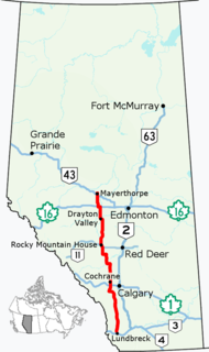
Alberta Provincial Highway No. 2, commonly referred to as Highway 2 or the Queen Elizabeth II Highway, is a major highway in Alberta that stretches from the Canada–United States border through Calgary and Edmonton to Grande Prairie. Running primarily north to south for approximately 1,273 kilometres (791 mi), it is the longest and busiest highway in the province carrying more than 170,000 vehicles per day near Downtown Calgary. The Fort Macleod—Edmonton section forms a portion of the CANAMEX Corridor that links Alaska to Mexico. More than half of Alberta's 4 million residents live in the Calgary–Edmonton Corridor created by Highway 2.
Alberta Provincial Highway No. 2A is the designation of six alternate routes off Highway 2 in Alberta, Canada. In general, these are original sections of Highway 2, such as the southern portion of Macleod Trail in Calgary. They passed through communities before limited-access freeways were built to shorten driving distance, accommodate heavier volumes and to bypass city traffic. Portions of the alignment of Highway 2A follow the route of the former Calgary and Edmonton Trail.
The Mackenzie Highway is a Canadian highway in northern Alberta and the Northwest Territories. It begins as Alberta Highway 2 at Mile Zero in Grimshaw, Alberta. After the first 4.0 km (2.5 mi), it becomes Alberta Highway 35 for the balance of its length through Alberta and then becomes Northwest Territories Highway 1.
Alberta Provincial Highway No. 22, commonly referred to as Highway 22 and officially named Cowboy Trail, is a 584-kilometre (363 mi) highway in the Canadian province of Alberta. It generally parallels Highway 2, beginning in the foothills of southern Alberta at Highway 3 near Lundbreck Falls. It proceeds north along the eastern slopes of the Rocky Mountains passing through the foothills and ranch country to the aspen parkland of northern Alberta, ending at Highway 18 near Mayerthorpe.
Grimshaw is a town in northern Alberta, Canada. It is approximately 25 km (16 mi) west of the Town of Peace River at the junction of Highway 2 and Highway 2A and along Mackenzie Northern Railway. By virtue of being the original starting point of Highway 35, which leads to the Northwest Territories, Grimshaw is referred to as Mile Zero of the Mackenzie Highway.
Alberta Provincial Highway No. 21, commonly referred to as Highway 21, is a north-south highway in Alberta, Canada that parallels Highway 2 between Calgary and Edmonton. It is approximately 328 kilometres (204 mi) in length. It begins at the Trans-Canada Highway (Highway 1) east of Strathmore, and ends at Fort Saskatchewan where it is succeeded by Highway 15. The northernmost 25 kilometres (16 mi) of the highway are twinned. Highway 21 runs roughly parallel to the main north-south CN rail line between Calgary and Edmonton between Three Hills and Looma.
Alberta Provincial Highway No. 10, commonly referred to as Highway 10, is a 22 km (14 mi) highway in southern Alberta, Canada that forms a part of Hoo Doo Trail. It is located wholly within the Town of Drumheller as a result of the former City of Drumheller's amalgamation with the Municipal District of Badlands No. 7 on January 1, 1998. It begins at Highway 9 in the heart of Drumheller and extends southeast along the Red Deer River where it passes through Rosedale, then crosses Highway 56 and travels through East Coulee. It ends by splitting off into Highways 570, 564, and 569.
Highway 17 is a highway in Canada that straddles and criss-crosses the Alberta–Saskatchewan provincial border. The portion from the provincial border at Dillberry Lake Provincial Park to the provincial border 800 metres (2,600 ft) north of the North Saskatchewan River is designated as Alberta Provincial Highway No. 17 by Alberta Transportation, commonly referred to as Highway 17.
Alberta Provincial Highway No. 20, commonly referred to as Highway 20, is a highway in central Alberta, Canada, west of Highway 2.
Alberta Provincial Highway No. 23, commonly referred to as Highway 23, is a highway in southern Alberta, Canada, east of Highway 2 that serves as an alternate route between Calgary and Lethbridge.
Alberta Provincial Highway No. 24, commonly referred to as Highway 24, is a highway in southern Alberta, Canada, east of Calgary.
Alberta Provincial Highway No. 27, commonly referred to as Highway 27, is an east-west highway in central Alberta, Canada. It extends from Highway 22 in Sundre, through Olds along 46 Street, and intersects Highway 2 6 km (3.7 mi) east of Olds. It continues east where it intersects Highway 21 4 km (2.5 mi) south of Trochu where it branches south, passes Three Hills, and branches east 10 km (6.2 mi) to the south. The highway ends at intersection of Highways 9 and 56, 5 km (3.1 mi) east of Morrin and 21 km (13 mi) north of Drumheller.
Alberta Provincial Highway No. 32, commonly referred to as Highway 32, is a north–south highway in west–central Alberta, Canada. From north to south, Highway 32 begins at its junction with Highway 33 in the Town of Swan Hills. It proceeds south for 69 km (43 mi) where it meets Highway 43 northwest of Whitecourt. After following Highway 43 southeast for 8 km (5.0 mi), Highway 32 continues south from Whitecourt for 72 km (45 mi), crossing the McLeod River, passing through the Hamlet of Peers, and ending at Highway 16 approximately 32 km (20 mi) east of the Town of Edson.
Alberta Provincial Highway No. 33, commonly referred to as Highway 33 and officially named Grizzly Trail, is a north–south highway in west–central Alberta, Canada.
Alberta Provincial Highway No. 16A, commonly referred to as Highway 16A, is the designation of three alternate routes off Alberta Highway 16 in Alberta, Canada. The Evansburg – Entwistle section is called 16A:08 by Alberta Transportation, while 16A:24 runs through Vegreville. The section west of Edmonton is labelled 16A:14 and 16A:16 on Alberta Transportation maps, but is better known as Parkland Highway and Stony Plain Road.
Alberta Provincial Highway No. 49, commonly referred to as Highway 49, is a highway in northwestern Alberta, Canada. It runs east-west from the British Columbia border to Donnelly, and then north-south to Valleyview. Highway 49 has a total length of 266 kilometres (165 mi).
Mackenzie County is a specialized municipality in northern Alberta, Canada. It is located in Census Division 17, along the Mackenzie Highway. Mackenzie County municipal office is located in the Hamlet of Fort Vermilion.
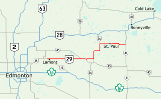
Alberta Provincial Highway No. 29, commonly referred to as Highway 29, is a 153-kilometre (95 mi) highway in east–central Alberta, Canada that connects Highway 15 near Lamont to Highway 41 north of Elk Point. It runs mostly west to east across aspen parkland through Hairy Hill, turning north through Duvernay, Brosseau, Foisy, St. Brides, and east to St. Paul before ending at Highway 41 approximately 9 km (5.6 mi) north of Elk Point, concurrent with Highways 36 and 45 for lengthy sections.
Alberta Provincial Highway No. 686, also known as Highway 686, is an east–west highway in northern Alberta, Canada. It has two sections; the main section is a gravel highway that spans approximately 90 kilometres (56 mi) from Highway 88 near Red Earth Creek to Trout Lake, and a two-kilometre-long (1.2 mi) developing freeway section in Fort McMurray which connects Highway 63 with the new neighbourhood of Parsons Creek known as Parsons Access Road.
Alberta Provincial Highway No. 986, commonly referred to as Highway 986, is an east-west highway in Northern Alberta. It spans approximately 158 km (98 mi) from Highway 35 to Highway 88.
Route map:
KML file (edit • help) |