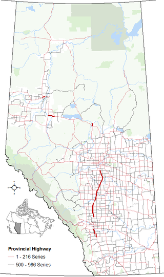
Alberta Provincial Highway No. 2A is the designation of six alternate routes off Highway 2 in Alberta, Canada. In general, these are original sections of Highway 2, such as the southern portion of Macleod Trail in Calgary. They passed through communities before limited-access freeways were built to shorten driving distance, accommodate heavier volumes and to bypass city traffic. Portions of the alignment of Highway 2A follow the route of the former Calgary and Edmonton Trail.

Alberta Provincial Highway No. 22, commonly referred to as Highway 22 and officially named Cowboy Trail, is a 584-kilometre (363 mi) highway in the Canadian province of Alberta. It generally parallels Highway 2, beginning in the foothills of southern Alberta at Highway 3 near Lundbreck Falls. It proceeds north along the eastern slopes of the Rocky Mountains passing through the foothills and ranch country to the aspen parkland of northern Alberta, ending at Highway 18 near Mayerthorpe.
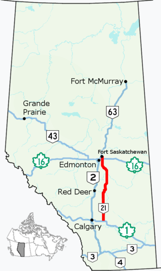
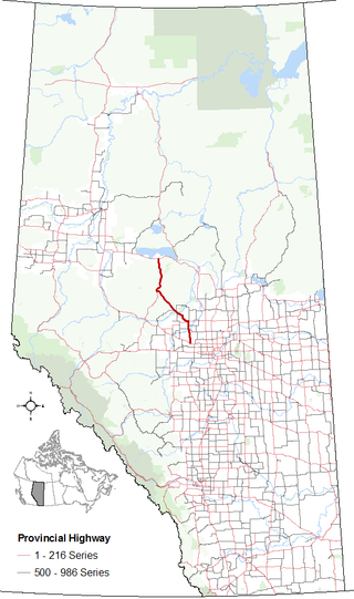
Alberta Provincial Highway No. 21, commonly referred to as Highway 21, is a north–south highway in Alberta, Canada that parallels Highway 2 between Calgary and Edmonton. It is approximately 328 kilometres (204 mi) in length. It begins at the Trans-Canada Highway (Highway 1) east of Strathmore, and ends at Fort Saskatchewan where it is succeeded by Highway 15. The northernmost 25 kilometres (16 mi) of the highway are twinned. Highway 21 runs roughly parallel to the main north–south CN rail line between Calgary and Edmonton between Three Hills and Looma.

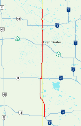
Alberta Provincial Highway No. 14, commonly referred to as Highway 14, is an east-west highway in central Alberta, Canada. It stretches from Edmonton through Wainwright to the Alberta–Saskatchewan border, running parallel to the more northern Highway 16. Highway 14 is about 257 kilometres (160 mi) long.
Alberta Provincial Highway No. 13, commonly referred to as Highway 13, is an east–west highway through central Alberta. It runs from Alder Flats, 7 km (4 mi) west of Highway 22, to the Alberta-Saskatchewan border, where it becomes Saskatchewan Highway 14. Highway 13 is about 366 kilometres (227 mi) long. East of the City of Wetaskiwin, it generally parallels a Canadian Pacific rail line.

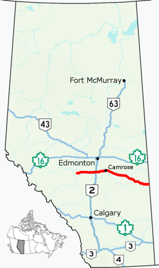
Alberta Provincial Highway No. 12, commonly referred to as Highway 12, is an east-west highway through central Alberta. It runs from Highway 22, through Lacombe and Stettler, to the Alberta-Saskatchewan border. It generally runs parallel to Highway 13 to the north. Highway 12 is about 364 kilometres (226 mi) long.

Alberta Provincial Highway No. 9, commonly referred to as Highway 9, is a highway in south-central Alberta, Canada, which together with Saskatchewan Highway 7 connects Calgary to Saskatoon, Saskatchewan via Drumheller. It is designated as a core route of the National Highway System, forming a portion of an interprovincial corridor. Highway 9 spans approximately 324 km (201 mi) from the Trans-Canada Highway east of Calgary to Alberta's border with Saskatchewan.

Alberta Provincial Highway No. 10, commonly referred to as Highway 10, is a 22 km (14 mi) highway in southern Alberta, Canada that forms a part of Hoo Doo Trail. It is located wholly within the Town of Drumheller as a result of the former City of Drumheller's amalgamation with the Municipal District of Badlands No. 7 on January 1, 1998. It begins at Highway 9 in the heart of Drumheller and extends southeast along the Red Deer River where it passes through Rosedale, then crosses Highway 56 and travels through East Coulee. It ends by splitting off into Highways 570, 564, and 569.
Highway 17 is a highway in Canada that straddles and criss-crosses the Alberta–Saskatchewan provincial border. The portion from the provincial border at Dillberry Lake Provincial Park to the provincial border 800 metres (2,600 ft) north of the North Saskatchewan River is designated as Alberta Provincial Highway No. 17 by Alberta Transportation, commonly referred to as Highway 17.
Alberta Provincial Highway No. 33, commonly referred to as Highway 33 and officially named Grizzly Trail, is a north–south highway in west–central Alberta, Canada.

Alberta Provincial Highway No. 56, commonly referred to as Highway 56, is a north-south highway in central Alberta, Canada. It begins 20 km (12 mi) northwest of Bassano at its intersection with Highway 1. It continues through Drumheller and Stettler and before ending at intersection with Highway 13 and Highway 834 9 km (6 mi) southeast of Camrose.

Alberta Provincial Highway No. 16A, commonly referred to as Highway 16A, is the designation of three alternate routes off Alberta Highway 16 in Alberta, Canada. The Evansburg – Entwistle section is called 16A:08 by Alberta Transportation, while 16A:24 runs through Vegreville. The section west of Edmonton is labelled 16A:14 and 16A:16 on Alberta Transportation maps, but is better known as Parkland Highway and Stony Plain Road.

Alberta Provincial Highway No. 49, commonly referred to as Highway 49, is a highway in northwestern Alberta, Canada. It runs east-west from the British Columbia border to Donnelly, and then north-south to Valleyview. Highway 49 has a total length of 266 kilometres (165 mi).
Alberta Provincial Highway No. 575, commonly referred to as Highway 575, is the designation of an east-west highway in central Alberta, Canada. It runs from the Highway 791, through Acme and Carbon, to Highway 9 and Highway 56 in Drumheller. The section between Highway 837 and Drumheller is part of the Dinosaur Trail.
Alberta Provincial Highway No. 806, commonly referred to as Highway 806, is a north–south highway in central Alberta, Canada. It runs from the Highway 9 / Highway 72 junction in the Village of Beiseker, through the Villages of Acme and Linden, to Highway 583 located 16 km (10 mi) west of the Town of Three Hills.
Alberta Provincial Highway No. 873, commonly referred to as Highway 873, is a highway in southern Alberta, Canada. It generally runs north-south from Range Road 162 near the Hamlet of Rainier, through the City of Brooks to Highway 550 in Village of Duchess.
Alberta Provincial Highway No. 16X, commonly referred to as Highway 16X, is the designation of one former and three proposed routes off Highway 16 in Alberta, Canada. The former section was a 36 km (22 mi) east–west provincial highway in Edmonton Capital Region, that existed for approximately 20 years between the 1970s and 1997 and is now part of Highway 16. Right of way is set aside around Hinton, Edson, and Lloydminster that is presently designated as Highway 16X.
Alberta Provincial Highway No. 21A, commonly referred to as Highway 21A, was the designation of two former spur routes of Highway 21 in Alberta, Canada.
Alberta Provincial Highway No. 57, commonly referred to as Highway 57, was a highway in central Alberta, Canada that served the Town of Drayton Valley and existed between the 1950s and 1979. It is now part of Highway 22 and Highway 39.
Alberta Provincial Highway No. 46, commonly referred to as Highway 46, was a highway in north-central Alberta, Canada connecting Edmonton to Lac La Biche. It existed between the 1950s and 1970s, and has formed portions of Highways 55 and 63 since the late 1970s.

