Glendon, Alberta

Last updated
Glendon
Village of Glendon
World's Largest Perogy.jpg
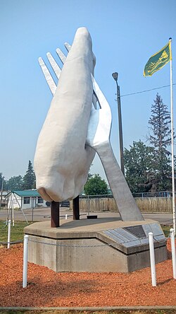
World's largest pierogi sculpture
Flag of Glendon.jpg
Alberta County Point Locator.svg
Red pog.svg
Glendon
Coordinates: 54°14′54″N111°09′13″W / 54.24833°N 111.15361°W / 54.24833; -111.15361
CountryCanada
Province Alberta
Region Northern Alberta
Census division 12
Municipal district M.D of Bonnyville No. 87
Incorporated [1]  
   Village January 1, 1956
Government
[2]
  MayorNicholas Werstiuk
  Governing bodyGlendon Village Council
Area
 (2021) [3]
  Land1.99 km2 (0.77 sq mi)
Elevation
587 m (1,926 ft)
Population
 (2021) [3]
  Total338
  Density169.5/km2 (439/sq mi)
Time zone UTC−7 (MST)
  Summer (DST) UTC−6 (MDT)
Postal code
T0A 1P0
Highways Highway 882
Highway 660
Website Official website

Glendon is a village in northern Alberta, Canada that is north of St. Paul. The community has the maiden name of an early postmaster's mother. [4]

Contents

In 1993, the town unveiled its roadside tribute to the perogy. Their "Giant Perogy," complete with fork, is 7.6 m (24.9 ft) in height. [5] It is one of the Giants of the Prairies. [6] Next to the roadside attraction was the Perogy Cafe, which served "Ukrainian and Chinese Perogies" it is now closed. Glendon is home to former NHLer Stan Smyl.

Demographics

In the 2021 Census of Population conducted by Statistics Canada, the Village of Glendon had a population of 338 living in 136 of its 168 total private dwellings, a change of

In the 2016 Census of Population conducted by Statistics Canada, the Village of Glendon recorded a population of 493 living in 208 of its 234 total private dwellings, a

See also

Related Research Articles

<span class="mw-page-title-main">Youngstown, Alberta</span> Village in Alberta, Canada

Youngstown is a village in southern Alberta, Canada within Special Area No. 3. The village refers to itself as a Sportsman's Paradise due to plenty of wild game and trout fishing in the area.

<span class="mw-page-title-main">Municipal District of Bonnyville No. 87</span> Municipal district in Alberta, Canada

The Municipal District of Bonnyville No. 87 is a municipal district (MD) in northeastern Alberta, Canada in Division No. 12. On the east, it is adjacent to the province of Saskatchewan.

<span class="mw-page-title-main">Andrew, Alberta</span> Village in Alberta, Canada

Andrew is a village in central Alberta, Canada that is northeast of Edmonton. Andrew is home of the world's largest duck roadside attraction, part of the Giants of the Prairies. Its post office was established March 2, 1902. The community has the name of Andrew Whitford, an early settler.

<span class="mw-page-title-main">Carbon, Alberta</span> Village in Alberta, Canada

Carbon is a village in central Alberta, Canada.

<span class="mw-page-title-main">Donnelly, Alberta</span> Village in Alberta, Canada

Donnelly is a village in northern Alberta, Canada within the Municipal District of Smoky River No. 130. It is located near the intersection of Highway 2 and Highway 49, located approximately 65 km (40 mi) south of Peace River and 427 km (265 mi) northwest of Edmonton.

<span class="mw-page-title-main">Girouxville</span> Village in Alberta, Canada

Girouxville is a village in northern Alberta, Canada. It is located 58 kilometres (36 mi) south of the Town of Peace River.

Heisler is a village in central Alberta, Canada. It is located 23 km south of Daysland and 20 km north of Forestburg.

<span class="mw-page-title-main">Holden, Alberta</span> Village in Alberta, Canada

Holden is a village in central Alberta, Canada. It is located south of Vegreville. The village is named after former Alberta MLA James Holden.

Innisfree is a village in central Alberta, Canada. It is located 52 km west of Vermilion along the Yellowhead Highway.

<span class="mw-page-title-main">Kinuso</span> Hamlet in Alberta, Canada

Kinuso is a hamlet in northern Alberta, Canada within Big Lakes County, and surrounded by the Swan River First Nation reserve. It is located approximately 48 kilometres (30 mi) west of Slave Lake and 71 km east of High Prairie along Highway 2, south of the southern shore of Lesser Slave Lake.

<span class="mw-page-title-main">Lougheed, Alberta</span> Village in Alberta, Canada

Lougheed is a village in central Alberta, Canada. It is 94 km south-east of Camrose, along Highway 13. The village was named after Sir James Lougheed, an Alberta senator from 1889 to 1925.

<span class="mw-page-title-main">Vilna, Alberta</span> Village in Alberta, Canada

Vilna is a village in central Alberta, Canada.

<span class="mw-page-title-main">Municipal District of Acadia No. 34</span> Municipal district in Alberta, Canada

The Municipal District of Acadia No. 34 is a municipal district (MD) in southern Alberta, Canada, east of Calgary, close to the Saskatchewan border, in Census Division No. 4.

Birch Cove is a summer village in Alberta, Canada. It is located between Highway 33 and Lac la Nonne, 99 kilometres (62 mi) northwest of Edmonton.

Norglenwold is a summer village in central Alberta, Canada. It is located on the southeast shore of Sylvan Lake adjacent to the Town of Sylvan Lake.

<span class="mw-page-title-main">Sunbreaker Cove</span> Summer village in Alberta, Canada

Sunbreaker Cove is a summer village in Alberta, Canada. It is located on the northern shore of Sylvan Lake.

South Baptiste is a summer village in Alberta, Canada. It is located on the southern shore of Baptiste Lake, west of Athabasca.

<span class="mw-page-title-main">Bonnyville Beach</span> Summer village in Alberta, Canada

Bonnyville Beach is a summer village in Alberta, Canada. It is located in the Municipal District of Bonnyville No. 87.

Sunset Beach is a summer village in Alberta, Canada. It is located on the eastern shore of Baptiste Lake.

Islay is a hamlet in central Alberta, Canada within the County of Vermilion River. Previously an incorporated municipality, Islay dissolved from village status on March 15, 1944, to become part of the Municipal District of Vermilion Valley No. 482. The community was named after Islay, in Scotland, the ancestral home of pioneer settlers.

References

  1. "Location and History Profile: Village of Glendon" (PDF). Alberta Municipal Affairs. October 21, 2016. p. 323. Retrieved October 23, 2016.
  2. "Municipal Officials Search". Alberta Municipal Affairs. May 9, 2019. Retrieved October 1, 2021.
  3. 1 2 3 "Population and dwelling counts: Canada, provinces and territories, and census subdivisions (municipalities)". Statistics Canada. February 9, 2022. Retrieved February 9, 2022.
  4. Place-names of Alberta. Ottawa: Geographic Board of Canada. 1928. p. 58.
  5. Municipal District of Bonnyville. Glendon Giant Perogy Archived 2006-01-27 at the Wayback Machine
  6. Big Things. Glendon Perogy Archived 2012-03-11 at the Wayback Machine
  7. "Population and dwelling counts, for Canada, provinces and territories, and census subdivisions (municipalities), 2016 and 2011 censuses – 100% data (Alberta)". Statistics Canada. February 8, 2017. Retrieved February 8, 2017.