Red Deer River

Last updated

Red Deer River
Red deer river.jpg
Red Deer River in Drumheller, Alberta
Location
CountryCanada
Physical characteristics
Source 
  location Sawback Range, Red Deer Lakes
  coordinates 51°31′55.96″N116°02′31.24″W / 51.5322111°N 116.0420111°W / 51.5322111; -116.0420111 (Red Deer River origin)
  elevation2,200 m (7,200 ft)
Mouth  
  location
South Saskatchewan River near Empress
  coordinates
50°55′23.34″N109°53′41.75″W / 50.9231500°N 109.8949306°W / 50.9231500; -109.8949306 (Red Deer River mouth)
  elevation
579 m (1,900 ft)
Length724 km (450 mi)
Basin size45,100 km2 (17,400 sq mi)
Discharge 
  average70 m3/s (2,500 cu ft/s) [1]

The Red Deer River is a river in Alberta and a small portion of Saskatchewan, Canada. It is a major tributary of the South Saskatchewan River and is part of the larger Saskatchewan / Nelson system that empties into Hudson Bay. [2]

Contents

The river has a total length of 724 km (450 mi) and a drainage area of 45,100 km2 (17,400 sq mi). Its mean discharge is 70 m3/s (2,500 cu ft/s). [1]

The river is named for the translation of a native term for the river, wâwâskêsiw sîpiy, which means "elk river" in the Cree language. [3] "Red deer" was an alternative name for elk, referring to a closely related Eurasian species.

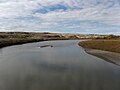
Communities located along the Red Deer River include Sundre, Red Deer, Drumheller, and Empress, The city of Brooks, as well as Dinosaur Provincial Park, are also located in the Red Deer River Basin. A glacial flood about 18,000 years ago eroded out a portion of this basin and apparently all or most of the scenic badlands bearing the dinosaur and other Cretaceous fossils.

History

Map symbol-pin.svg
Alberta rivers.png

Joseph Tyrrell discovered a huge coal seam here in 1883, besides large dinosaur skeletons. [4]

2013 Alberta flood

In June 2013, Alberta, Canada, experienced heavy rainfall that triggered catastrophic flooding throughout much of the southern half of the province along the Bow, Elbow, Highwood, Oldman, and Red Deer rivers and tributaries. Twenty-four municipalities declared local states of emergency as water levels rose and numerous communities were placed under evacuation orders. [5] The Royal Canadian Mounted Police stated four people may have drowned near High River. [6] Over 100,000 people in the region were displaced. [7]

Course

The river originates on the eastern slopes of the Canadian Rockies, in the Sawback Range near the Skoki Valley inside Banff National Park, and then flows east through the mountains and foothills region. It turns north-east before Sundre and flows to an artificial reservoir named Gleniffer Lake, created in 1983 by the Dickson Dam and keeps this heading to the city of Red Deer, where it turns east, and then south before Stettler. It flows south with its valley protected by provincial and regional parks such as Tolman Badlands Heritage Rangeland, Dry Island Buffalo Jump Provincial Park, Dry Island Corridor and Midland Provincial Park. At Drumheller it has a south-east direction, and while it flows through Dinosaur Provincial Park it turns east and flows to the Alberta/Saskatchewan border, which it crosses at Empress. It flows for 16 km (9.9 mi) through Saskatchewan before it merges into the South Saskatchewan River.

Tributaries

The waters of Ewing Lake, Little Fish Lake also flow into the Red Deer River. [9] [10]

Fish species

Sport fish include: walleye, northern pike, sauger, lake whitefish, yellow perch, burbot, lake sturgeon, mountain whitefish, goldeye, brown trout, bull trout, rainbow trout, brook trout, and cutthroat trout.

Other fish include: emerald shiner, river shiner, spottail shiner, flathead chub, longnose dace, quillback (quillback carpsucker), longnose sucker, white sucker, shorthead redhorse, silver redhorse, perch, spoonhead sculpin, lake chub, northern pearl dace, northern redbelly dace, finescale dace, fathead minnow and brook stickleback.

Environmental concerns

Pipeline leaks

The Red Deer River is the water source for the City of Red Deer and the surrounding area. Pipelines cross under the river and there have been leaks disrupting access to potable water. [13] Increased water flow of the Red Deer River system during heavy rainfall in June 2008 eroded supporting soil, freely exposing a section of Pembina Pipeline Corporation's Cremona crude oil pipeline to the Red Deer River currents. About 75 to 125 barrels (11,900 to 19,900 L; 2,600 to 4,400 imp gal; 3,200 to 5,200 US gal) of crude oil flowed upstream from the break point under a Red Deer River channel, leaving an oily sheen on Gleniffer Reservoir and 6,800 kg (15,000 lb) of oil-soaked debris. [14] [15] The remediation was not completed until 2011. [16]

Heavy rains in early June 2012 caused a similar but larger leak on a Plains Midstream Canada 46-year-old pipeline on a Red Deer River tributary, Jackson Creek, Alberta ( 51°52′19″N114°36′23″W / 51.87194°N 114.60639°W / 51.87194; -114.60639 (Jackson Creek) [17] ) near Gleniffer Lake and Dickson Dam, [18] which spilled approximately 1,000 and 3,000 barrels (160,000 and 480,000 L; 35,000 and 105,000 imp gal; 42,000 and 126,000 US gal) of light sour crude oil into the Red Deer River. [16] [19]

Climate

Red Deer

Red Deer has a humid continental climate (Köppen Dfb), with something of a semi-arid influence due to the city's location within Palliser's Triangle. The highest temperature ever recorded in Red Deer was 37.2 °C (99.0 °F) on 8 July 1906, [20] 2 July 1924, [21] and 28 & 29 June 1937. [22] The lowest recorded temperature was −50.6 °C (−59.1 °F) on 17 December 1924. [23] The city lies in the 4a plant hardiness zone. [24] Summers are typically warm and rainy with cool nights. Winters are typically long, cold, and very dry.

Climate data for Red Deer (Red Deer Regional Airport)
WMO ID: 71878; coordinates 52°10′43″N113°53′35″W / 52.17861°N 113.89306°W / 52.17861; -113.89306 (Empress) ; elevation: 904.6 m (2,968 ft); 1981-2010 normals, extremes 1904−present
MonthJanFebMarAprMayJunJulAugSepOctNovDecYear
Record high humidex 10.517.324.828.237.035.038.537.134.227.821.714.838.5
Record high °C (°F)14.5
(58.1)
18.0
(64.4)
24.8
(76.6)
32.8
(91.0)
33.3
(91.9)
37.2
(99.0)
37.2
(99.0)
36.1
(97.0)
35.0
(95.0)
29.4
(84.9)
22.8
(73.0)
16.5
(61.7)
37.2
(99.0)
Average high °C (°F)−4.5
(23.9)
−1.7
(28.9)
2.9
(37.2)
11.3
(52.3)
16.8
(62.2)
20.5
(68.9)
23.1
(73.6)
22.5
(72.5)
17.3
(63.1)
11.2
(52.2)
1.3
(34.3)
−3.2
(26.2)
9.8
(49.6)
Daily mean °C (°F)−10.2
(13.6)
−7.7
(18.1)
−2.9
(26.8)
4.8
(40.6)
10.3
(50.5)
14.5
(58.1)
16.8
(62.2)
15.9
(60.6)
10.8
(51.4)
5.0
(41.0)
−3.8
(25.2)
−8.5
(16.7)
3.7
(38.7)
Average low °C (°F)−16
(3)
−13.7
(7.3)
−8.7
(16.3)
−1.7
(28.9)
3.7
(38.7)
8.4
(47.1)
10.5
(50.9)
9.2
(48.6)
4.3
(39.7)
−1.3
(29.7)
−8.8
(16.2)
−13.8
(7.2)
−2.3
(27.9)
Record low °C (°F)−46.7
(−52.1)
−44.4
(−47.9)
−40.6
(−41.1)
−31.7
(−25.1)
−12.8
(9.0)
−6.1
(21.0)
−1.1
(30.0)
−5.6
(21.9)
−12.8
(9.0)
−26.1
(−15.0)
−37.2
(−35.0)
−50.6
(−59.1)
−50.6
(−59.1)
Record low wind chill −60−54−50−39−21−70.0−5−14−38−49−57−60
Average precipitation mm (inches)22.2
(0.87)
13.1
(0.52)
21.2
(0.83)
21.5
(0.85)
55.8
(2.20)
89.3
(3.52)
96.6
(3.80)
63.1
(2.48)
51.1
(2.01)
20.7
(0.81)
17.7
(0.70)
14.1
(0.56)
486.3
(19.15)
Average rainfall mm (inches)0.1
(0.00)
0.2
(0.01)
0.8
(0.03)
12.9
(0.51)
51.9
(2.04)
89.3
(3.52)
96.6
(3.80)
63.1
(2.48)
48.7
(1.92)
14.6
(0.57)
1.8
(0.07)
0.4
(0.02)
380.4
(14.98)
Average snowfall cm (inches)22.1
(8.7)
12.9
(5.1)
20.4
(8.0)
8.5
(3.3)
3.9
(1.5)
0.0
(0.0)
0.0
(0.0)
0.0
(0.0)
2.4
(0.9)
6.1
(2.4)
15.8
(6.2)
13.7
(5.4)
105.9
(41.7)
Average precipitation days (≥ 0.2 mm)7.95.76.45.811.115.414.213.011.16.66.76.0110.0
Average rainy days (≥ 0.2 mm)0.080.150.544.010.615.414.213.010.94.90.960.1974.9
Average snowy days (≥ 0.2 cm)7.95.56.02.41.00.00.00.00.382.16.05.937.1
Average relative humidity (%) (at 1500 LST)65.562.858.643.743.250.151.549.94848.663.165.554.2
Source: Environment and Climate Change Canada [25] [20] [21] [23] [22] [26]

Empress

Empress is located in the steppe region known as Palliser's Triangle and experiences a semi-arid climate (Köppen climate classification BSk ). Winters are long, cold and dry, while summers are short, but with average daytime highs that are warm to hot, though nighttime lows are cool. Spring and autumn are quite short, essentially transition periods between winter and summer. Wide diurnal temperature ranges are regular, due to the aridity and moderately high elevation. Low humidity is prevalent throughout the year. Annual precipitation is very low, with an average of 311.6 mm (12.27 in), and is heavily concentrated in the warmer months. On average, the coldest month is January, with a mean temperature of −12 °C (10 °F), while the warmest is July, with a mean temperature of 19.8 °C (67.6 °F). The driest month is February, with an average of 8.6 mm (0.34 in) of precipitation, while the wettest is June, with an average of 68.9 mm (2.71 in). [27]

Climate data for Empress
Climate ID: 3022400; coordinates 50°57′21″N110°00′22″W / 50.95583°N 110.00611°W / 50.95583; -110.00611 (Empress) ; elevation: 612.0 m (2,007.9 ft); 1981-2010 normals
MonthJanFebMarAprMayJunJulAugSepOctNovDecYear
Record high °C (°F)12.0
(53.6)
17.0
(62.6)
28.0
(82.4)
32.0
(89.6)
36.0
(96.8)
41.1
(106.0)
42.2
(108.0)
41.7
(107.1)
38.3
(100.9)
31.7
(89.1)
23.0
(73.4)
15.0
(59.0)
42.2
(108.0)
Average high °C (°F)−6.5
(20.3)
−2.6
(27.3)
4.8
(40.6)
13.9
(57.0)
19.7
(67.5)
23.8
(74.8)
27.4
(81.3)
27.0
(80.6)
20.4
(68.7)
12.9
(55.2)
1.7
(35.1)
−4.7
(23.5)
11.5
(52.7)
Daily mean °C (°F)−12.0
(10.4)
−8.3
(17.1)
−1.2
(29.8)
6.6
(43.9)
12.5
(54.5)
16.9
(62.4)
19.8
(67.6)
19.1
(66.4)
12.8
(55.0)
5.8
(42.4)
−3.8
(25.2)
−10.1
(13.8)
4.8
(40.6)
Average low °C (°F)−17.5
(0.5)
−14.1
(6.6)
−7.2
(19.0)
−0.7
(30.7)
5.2
(41.4)
9.9
(49.8)
12.1
(53.8)
11.1
(52.0)
5.2
(41.4)
−1.2
(29.8)
−9.3
(15.3)
−15.4
(4.3)
−1.8
(28.8)
Record low °C (°F)−47.8
(−54.0)
−45.6
(−50.1)
−40.0
(−40.0)
−28.9
(−20.0)
−14.4
(6.1)
−4.4
(24.1)
0.0
(32.0)
0.0
(32.0)
−10.0
(14.0)
−26.0
(−14.8)
−36.5
(−33.7)
−45.0
(−49.0)
−47.8
(−54.0)
Average precipitation mm (inches)14.2
(0.56)
8.6
(0.34)
12.7
(0.50)
18.7
(0.74)
38.8
(1.53)
68.9
(2.71)
50.3
(1.98)
33.9
(1.33)
28.5
(1.12)
11.5
(0.45)
10.8
(0.43)
14.8
(0.58)
311.6
(12.27)
Average rainfall mm (inches)0.2
(0.01)
0.3
(0.01)
2.1
(0.08)
13.8
(0.54)
38.2
(1.50)
68.9
(2.71)
50.3
(1.98)
33.9
(1.33)
28.1
(1.11)
7.5
(0.30)
1.0
(0.04)
0.4
(0.02)
244.5
(9.63)
Average snowfall cm (inches)13.9
(5.5)
8.3
(3.3)
10.6
(4.2)
4.9
(1.9)
0.7
(0.3)
0.0
(0.0)
0.0
(0.0)
0.0
(0.0)
0.5
(0.2)
4.1
(1.6)
9.8
(3.9)
14.8
(5.8)
67.1
(26.4)
Average precipitation days (≥ 0.2 mm)4.32.63.63.56.510.06.95.85.43.33.04.359.1
Average rainy days (≥ 0.2 mm)0.120.120.52.76.410.06.95.85.42.40.320.2440.8
Average snowy days (≥ 0.2 cm)4.22.53.11.00.20.00.00.00.041.12.64.018.8
Source: Environment and Climate Change Canada [27]

See also

Related Research Articles

<span class="mw-page-title-main">Oil sands</span> Type of unconventional oil deposit

Oil sands, tar sands, crude bitumen, or bituminous sands, are a type of unconventional petroleum deposit. Oil sands are either loose sands or partially consolidated sandstone containing a naturally occurring mixture of sand, clay, and water, soaked with bitumen, a dense and extremely viscous form of petroleum.

<span class="mw-page-title-main">South Saskatchewan River</span> River in Western Canada

The South Saskatchewan River is a major river in the Canadian provinces of Alberta and Saskatchewan. The river begins at the confluence of the Bow and Oldman Rivers in southern Alberta and ends at the Saskatchewan River Forks in central Saskatchewan. The Saskatchewan River Forks is the confluence of the South and North Saskatchewan Rivers and is the beginning of the Saskatchewan River.

Enbridge Inc. is a multinational pipeline and energy company headquartered in Calgary, Alberta, Canada. Enbridge owns and operates pipelines throughout Canada and the United States, transporting crude oil, natural gas, and natural gas liquids, and also generates renewable energy. Enbridge's pipeline system is the longest in North America and the largest oil export pipeline network in the world. Its crude oil system consists of 28,661 kilometres of pipelines. Its 38,300 kilometre natural gas pipeline system connects multiple Canadian provinces, several US states, and the Gulf of Mexico. The company was formed by Imperial Oil in 1949 as the Interprovincial Pipe Line Company Limited to transport Alberta oil to refineries. Over time, it has grown through acquisition of other existing pipeline companies and the expansion of their projects.

The Enbridge Pipeline System is an oil pipeline system which transports crude oil and dilbit from Canada to the United States. The system exceeds 5,000 kilometres (3,100 mi) in length including multiple paths. More than 3,000 kilometres (1,900 mi) of the system is in the United States while the rest is in Canada and serves the Athabasca oil sands production facilities. Main parts of the system are 2,306-kilometre-long (1,433 mi) Canadian Mainline and 3,057-kilometre-long (1,900 mi) Lakehead System. On average, it delivers 1.4 million barrels per day of crude oil and other products to the major oil refineries in the American Midwest and the Canadian province of Ontario. The Canadian portion is owned by Enbridge, while the U.S. portion is partly owned by that company through Enbridge Energy Partners, LP, formerly known as Lakehead Pipe Line Partners and Lakehead Pipe Line Company.

<span class="mw-page-title-main">Cold Lake Provincial Park</span> Provincial park in Alberta, Canada

Cold Lake Provincial Park is a provincial park in northeastern Alberta, Canada.

<span class="mw-page-title-main">Dry Island Buffalo Jump Provincial Park</span> Provincial park in Alberta, Canada

Dry Island Buffalo Jump Provincial Park is a provincial park in Central Alberta, Canada, located about 103 km (64 mi) southeast of Red Deer and 16 km (9.9 mi) east of Trochu. The park is situated along the Red Deer River and features badlands topography. Its name derives from the large plateau in the middle of the park, 200 m (660 ft) above the Red Deer River, which has never been developed by humans and retains virgin prairie grasses.

<span class="mw-page-title-main">Hardisty, Alberta</span> Town in Alberta, Canada

Hardisty is a town in Flagstaff County in east-central Alberta, Canada. It is approximately 111 kilometres (69 mi) from the Saskatchewan border, near the crossroads of Highway 13 and Highway 881, in the Battle River Valley. Hardisty is mainly known as a pivotal petroleum industry hub where petroleum products such as Western Canada Select blended crude oil and Hardisty heavy oil are produced and traded.

Plains All American Pipeline, L.P. is a master limited partnership engaged in pipeline transport, marketing, and storage of liquefied petroleum gas and petroleum in the United States and Canada. Plains owns interests in 18,370 miles (29,560 km) of pipelines, storage capacity for about 75 million barrels of crude oil, 28 million barrels of NGLs, 68 billion cubic feet of natural gas, and 5 natural gas processing plants. The company is headquartered in the Allen Center in Downtown Houston, Texas. Plains is a publicly traded Master limited partnership. PAA owns an extensive network of pipeline transportation, terminalling, storage and gathering assets in key crude oil and NGL producing basins and transportation corridors and at major market hubs in the United States and Canada.

<span class="mw-page-title-main">Petroleum industry in Canada</span>

Petroleum production in Canada is a major industry which is important to the economy of North America. Canada has the third largest oil reserves in the world and is the world's fourth largest oil producer and fourth largest oil exporter. In 2019 it produced an average of 750,000 cubic metres per day (4.7 Mbbl/d) of crude oil and equivalent. Of that amount, 64% was upgraded from unconventional oil sands, and the remainder light crude oil, heavy crude oil and natural-gas condensate. Most of the Canadian petroleum production is exported, approximately 600,000 cubic metres per day (3.8 Mbbl/d) in 2019, with 98% of the exports going to the United States. Canada is by far the largest single source of oil imports to the United States, providing 43% of US crude oil imports in 2015.

Dilbit is a bitumen diluted with one or more lighter petroleum products, typically natural-gas condensates such as naphtha. Diluting bitumen makes it much easier to transport, for example in pipelines. Per the Alberta Oil Sands Bitumen Valuation Methodology, "Dilbit Blends" means "Blends made from heavy crudes and/or bitumens and a diluent, usually natural-gas condensate, for the purpose of meeting pipeline viscosity and density specifications, where the density of the diluent included in the blend is less than 800 kg/m3." If the diluent density is greater than or equal to 800 kg/m3, the diluent is typically synthetic crude and accordingly the blend is called synbit.

<span class="mw-page-title-main">Southern Alberta</span> Region of Alberta, Canada (est. 1905)

Southern Alberta is a region located in the Canadian province of Alberta. In 2016, the region's population was approximately 291,112. The primary cities are Lethbridge and Medicine Hat. The region is known mostly for agricultural production, but other sectors, such as alternative energy, film production and tourism, are emerging.

O'Brien Provincial Park is a provincial park in Alberta, Canada, located 15 km (9.3 mi) south from Grande Prairie, on Highway 666.

Gleniffer Lake also known as Gleniffer Reservoir or originally Lake Gleniffer is an artificial lake in central Alberta, Canada created in 1983 by the construction of the Dickson Dam which impounded the Red Deer River, a major tributary of the South Saskatchewan River which flows into the Saskatchewan River Basin.

<span class="mw-page-title-main">Dickson Dam</span> Dam in Red Deer County, Alberta

Dickson Dam is a flow regulation dam constructed in 1983 which impounded the Red Deer River creating a reservoir known as Gleniffer Lake (Alberta). The dam is located 20 km (12 mi) west of the town of Innisfail and 50 km (31 mi) southwest of the city of Red Deer. The dam was created to control for floods and low winter flows, to improve quality of the river, to create a recreational resource and to provide a reliable, year-round water supply sufficient for future industrial, regional and municipal growth.

<span class="mw-page-title-main">2013 Mayflower oil spill</span>

The 2013 Mayflower oil spill occurred on March 29, 2013, when the Pegasus Pipeline, owned by ExxonMobil and carrying Canadian Wabasca heavy crude from the Athabasca oil sands, ruptured in Mayflower, Arkansas, about 25 miles (40 km) northwest of Little Rock releasing about 3,190 barrels of oil. Approximately 3,190 barrels of oil and water mix was recovered. Twenty-two homes were evacuated. The United States Environmental Protection Agency (EPA) classified the leak as a major spill.

Hubert Lake Wildland Provincial Park is a wildland provincial park in central Alberta, Canada. The park was established on 4 October 2000 and has an area of 9,665.46 hectares. The park is included in the Upper Athabasca Region Land Use Framework.

<span class="mw-page-title-main">Raven River</span> River in Alberta, Canada

The Raven River or South Raven River is a major tributary of the Red Deer River located in Central-Western Alberta, Canada. The river is located in both the Clearwater County and Red Deer County.

<span class="mw-page-title-main">North Raven River</span> River in Canada

The North Raven River or Stauffer Creek is a major tributary of the Raven River located in western Central Alberta, Canada. It is located in the Red Deer River system. The river is a popular place for anglers.

The Canadian province of Alberta faces a number of environmental issues related to natural resource extraction—including oil and gas industry with its oil sands—endangered species, melting glaciers in banff, floods and droughts, wildfires, and global climate change. While the oil and gas industries generates substantial economic wealth, the Athabasca oil sands, which are situated almost entirely in Alberta, are the "fourth most carbon intensive on the planet behind Algeria, Venezuela and Cameroon" according to an August 8, 2018 article in the American Association for the Advancement of Science's journal Science. This article details some of the environmental issues including past ecological disasters in Alberta and describes some of the efforts at the municipal, provincial and federal level to mitigate the risks and impacts.

References

  1. 1 2 Atlas of Canada. "Rivers in Canada". Archived from the original on 2 February 2007. Retrieved 1 May 2007.
  2. "From the Mountains to the Sea Summary of The State of The Saskatchewan River Basin" (PDF). Archived from the original (PDF) on 4 September 2014. Retrieved 29 August 2014.
  3. "itwêwina: the online Cree dictionary". itwewina.altlab.app. Retrieved 18 July 2023.
  4. Barnes, Michael (1986). Fortunes in the Ground. Erin, Ontario: The Boston Mills Press. p. 198. ISBN   091978352X.
  5. Wood, James (22 June 2013). "Harper, Redford promise to help". Calgary Herald. p. A5.
  6. Frisk, Adam; Tucker, Ericka; Stone, Laura (21 June 2013). "RCMP: 4 possibly dead in Alberta floods as Calgary continues evacuation". Global News. Retrieved 21 June 2013.
  7. "4 feared dead from Alberta floods". Canadian Broadcasting Corporation. 21 June 2013. Retrieved 21 June 2013.
  8. "Map of Jackson Creek, Alberta, River - Canada Geographical Names with Maps" . Retrieved 14 September 2023.
  9. "Natural Resources Canada-Canadian Geographical Names (Red Deer River)" . Retrieved 29 August 2014.
  10. "Atlas of Canada Toporama" . Retrieved 29 August 2014.
  11. "Assessment of Sport Fish Distribution and Relative Abundance in the Lower Red Deer River, Alberta, Phase II" (PDF). Archived from the original (PDF) on 4 March 2016. Retrieved 10 August 2015.
  12. "Waskasoo | Kerry Wood Nature Centre | Fort Normandeau" (PDF).
  13. "CBC.ca News - Alberta residents angry after oil spills into nearby lake". Archived from the original on 15 January 2013.
  14. Brian Temple; Doug Buechler; Dave Grzyb; Murray Barber; Jenny Miller; Phil Hendy; Mike Bevan (11 February 2009). ERCB Investigation Report: Pembina Pipeline Corporation, Crude Oil Pipeline Failure, June 15, 2008 (.pdf) (Report). Energy Resources Conservation Board . Retrieved 16 June 2012. The pipeline, leased to Pembina, was built in 1959.
  15. "Oil leaks into popular Alberta lake: Company previously fined in B.C. for pipeline rupture, spill in 2000". CBC. 6 June 2008. Retrieved 16 June 2012.
  16. 1 2 Bob Weber (14 June 2012). "Alberta pressured to include leaks in environmental monitoring plan". Financial Post. Retrieved 16 June 2012.
  17. "Jackson Creek". Geographical Names Data Base . Natural Resources Canada.
  18. Name: Jackson Creek [ dead link ]
  19. Stephen Ewart (16 June 2012). "Ewart: Calls growing for probe of aging pipeline system: Recent spills highlight ongoing risk". Calgary Herald. Archived from the original on 20 June 2012. Retrieved 16 June 2012.
  20. 1 2 "July 1906". Canadian Climate Data. Environment and Climate Change Canada. 31 October 2011. Retrieved 18 May 2016.
  21. 1 2 "July 1924". Canadian Climate Data. Environment and Climate Change Canada. 31 October 2011. Retrieved 18 May 2016.
  22. 1 2 "June 1937". Canadian Climate Data. Environment and Climate Change Canada. 31 October 2011. Retrieved 18 May 2016.
  23. 1 2 "December 1924". Canadian Climate Data. Environment and Climate Change Canada. 31 October 2011. Retrieved 18 May 2016.
  24. "Plant Hardiness Zone by Municipality". Natural Resources Canada. Government of Canada. Retrieved 19 October 2019.
  25. "Red Deer A". Canadian Climate Normals 1981–2010. Environment and Climate Change Canada. 14 July 2023. Retrieved 14 September 2014.
  26. "Red Deer (1904–1974)". Canadian Climate Data. Environment and Climate Change Canada. 31 October 2011. Retrieved 18 May 2016.
  27. 1 2 "Empress, Alberta". Canadian Climate Normals 1981–2010. Environment and Climate Change Canada. 14 July 2023. Retrieved 14 September 2023.