Upper Kananaskis Lake

Last updated
Upper Kananaskis Lake
Upper Kananaskis Lake aerial1.jpg
Kananaskis Lake
Canada Alberta relief location map - transverse mercator proj.svg
Red pog.svg
Upper Kananaskis Lake
Location in Alberta
Canada relief map 2.svg
Red pog.svg
Upper Kananaskis Lake
Upper Kananaskis Lake (Canada)
Location Kananaskis, Alberta
Coordinates 50°37′05″N115°09′15″W / 50.61806°N 115.15417°W / 50.61806; -115.15417
Type Reservoir, oligotrophic
Primary inflows Upper Kananaskis River
Primary outflows Lower Kananaskis Lake
Catchment area 139 km2 (54 sq mi) [1]
Basin  countriesCanada
Surface area7.8 km2 (3.0 sq mi) [1]
Average depth32 m (105 ft)
Max. depth108 m (354 ft)
Surface elevation1,720 m (5,640 ft)
References [1]

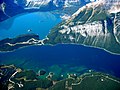
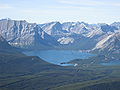
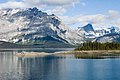
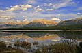
Upper Kananaskis Lake is a natural lake that was turned into a reservoir in Kananaskis Country in Alberta, Canada.

Contents

Upper Kananaskis Lake, along with the Lower Kananaskis Lake, is located in Peter Lougheed Provincial Park .

The lake is part of a series of natural and man made lakes in the Kananaskis and Bow Valleys used for hydro electric power, flood control, and water reserves for the Bow River water users such as the city of Calgary.

The lake is also used for recreational activities, with hiking paths surrounding the lake (and cross-country skiing trails in the winter).

Hiking trails

Climate

Based on the Köppen climate classification, this vicinity is located in a subarctic climate with cold, snowy winters, and mild summers. [2] Temperatures can drop below −20 C with wind chill factors below −30 C.

Climate data for Kananaskis Pocaterra, Alberta (1981-2010):1610m
MonthJanFebMarAprMayJunJulAugSepOctNovDecYear
Record high °C (°F)11.5
(52.7)
12.0
(53.6)
16.0
(60.8)
24.5
(76.1)
28.5
(83.3)
28.0
(82.4)
32.0
(89.6)
33.0
(91.4)
30.0
(86.0)
25.5
(77.9)
15.5
(59.9)
12.0
(53.6)
33.0
(91.4)
Mean daily maximum °C (°F)−2.8
(27.0)
−0.4
(31.3)
3.2
(37.8)
7.9
(46.2)
13.3
(55.9)
16.9
(62.4)
20.6
(69.1)
20.5
(68.9)
15.6
(60.1)
9.4
(48.9)
1.0
(33.8)
−3.6
(25.5)
8.5
(47.2)
Daily mean °C (°F)−9.7
(14.5)
−8.1
(17.4)
−3.9
(25.0)
1.1
(34.0)
5.9
(42.6)
9.4
(48.9)
12.1
(53.8)
11.6
(52.9)
7.5
(45.5)
2.4
(36.3)
−5.0
(23.0)
−10.1
(13.8)
1.1
(34.0)
Mean daily minimum °C (°F)−16.5
(2.3)
−15.8
(3.6)
−11.0
(12.2)
−5.8
(21.6)
−1.6
(29.1)
1.9
(35.4)
3.5
(38.3)
2.7
(36.9)
−0.8
(30.6)
−4.6
(23.7)
−10.9
(12.4)
−16.5
(2.3)
−6.3
(20.7)
Record low °C (°F)−44.0
(−47.2)
−42.0
(−43.6)
−39.5
(−39.1)
−25.5
(−13.9)
−17.0
(1.4)
−6.1
(21.0)
−12.0
(10.4)
−6.0
(21.2)
−16.0
(3.2)
−26.0
(−14.8)
−37.0
(−34.6)
−42.8
(−45.0)
−44.0
(−47.2)
Average precipitation mm (inches)37.8
(1.49)
28.5
(1.12)
34.7
(1.37)
44.6
(1.76)
67.1
(2.64)
91.5
(3.60)
56.9
(2.24)
56.4
(2.22)
43.0
(1.69)
36.6
(1.44)
40.6
(1.60)
30.5
(1.20)
568.2
(22.37)
Average snowfall cm (inches)36.9
(14.5)
28.2
(11.1)
34.6
(13.6)
36.3
(14.3)
22.3
(8.8)
2.5
(1.0)
0.3
(0.1)
0.3
(0.1)
8.7
(3.4)
18.6
(7.3)
36.0
(14.2)
30.6
(12.0)
255.3
(100.4)
Source: Environment Canada [3]

Related Research Articles

<span class="mw-page-title-main">Mount Galatea</span> Mountain in Alberta, Canada

Mount Galatea is the highest peak of the Kananaskis Range, a subrange of the Canadian Rockies in the province of Alberta. It is located in the upper Spray Lakes Valley of the Kananaskis Country system of provincial parks. The mountain was named after the Royal Navy cruiser HMS Galatea.

<span class="mw-page-title-main">Mount Engadine</span> Mountain in the Spray River Valley, Alberta, Canada

Mount Engadine is a 2,972-metre (9,751-foot) mountain summit located in the Spray River Valley of Kananaskis Country, in the Canadian Rockies of Alberta, Canada. It was named in 1917 after HMS Engadine, a seaplane tender of the Royal Navy present at the Battle of Jutland during World War I. The mountain is located in the Kananaskis Range in Alberta.

<span class="mw-page-title-main">Mount James Walker</span> Mountain in the country of Canada

Mount James Walker is a 3,035-metre (9,957-foot) mountain summit located in Kananaskis Country in the Canadian Rockies of Alberta, Canada. Mount James Walker is situated within Spray Valley Provincial Park, and its nearest higher peak is Mount Galatea, 5.0 km (3.1 mi) to the northwest.

<span class="mw-page-title-main">Mount Black Prince (Alberta)</span>

Mount Black Prince is a 2,939-metre (9,642-foot) mountain summit located in Peter Lougheed Provincial Park in the Canadian Rockies of Alberta, Canada. Its nearest higher peak is Mount Smith Dorrien, 5.8 km (3.6 mi) to the northwest. The mountain can be seen from Highway 742, also known as Smith-Dorrien/Spray Trail.

<span class="mw-page-title-main">Mount Bogart</span> Mountain in the country of Canada

Mount Bogart is a 3,144-metre (10,315-foot) summit located in Kananaskis Country in the Canadian Rockies of Alberta, Canada. Mount Bogart's nearest higher peak is Wind Mountain, 4.7 km (2.9 mi) to the north. Mount Bogart is situated northwest of Mount Kidd, and both can be seen from Highway 40 near the Kananaskis Village junction.

<span class="mw-page-title-main">Mount Invincible</span> Mountain in Alberta, Canada

Mount Invincible is a 2,700-metre (8,900-foot) mountain summit located in Peter Lougheed Provincial Park in the Canadian Rockies of Alberta, Canada. The peak is visible from Alberta Highway 40, and the Upper and Lower Kananaskis Lakes area. Mount Invincible's nearest higher peak is Mount Warspite, 2.6 km (1.6 mi) to the northwest.

<span class="mw-page-title-main">Windtower (Alberta)</span> Mountain in Alerta, Canada

Windtower is a 2,695-metre (8,842-foot) tower-like summit located in the Wind Valley of Kananaskis Country in the Canadian Rockies of Alberta, Canada. Its nearest higher peak is Mount Lougheed, 3.0 km (1.9 mi) to the southeast. Windtower is a conspicuous landmark that can be seen from Highway 1, the Trans-Canada Highway in the Canmore area. Although not of remarkable elevation, the mountain has an imposing, overhanging north face with an appearance similar to peaks in The Bugaboos.

<span class="mw-page-title-main">Mount McGillivray</span> Mountain in Alberta, Canada

Mount McGillivray is a 2,451-metre (8,041-foot) mountain summit located in the Bow Valley of Kananaskis Country in the Canadian Rockies of Alberta, Canada. Its nearest higher peak is Skogan Peak, 3.0 km (1.9 mi) to the southeast. Mount McGillivray is a landmark that can be seen from Highway 1, the Trans-Canada Highway in the Exshaw area.

<span class="mw-page-title-main">Mount Kidd</span> Mountain in Alberta, Canada

Mount Kidd is a 2,958-metre (9,705-foot) double-summit massif centrally located in Kananaskis Country in the Canadian Rockies of Alberta, Canada. Mount Kidd is situated within Spray Valley Provincial Park, and its nearest higher neighbor is Mount Sparrowhawk, 7.0 km (4.3 mi) to the northwest. Mount Kidd is a landmark that can be seen from Highway 40 in the Kananaskis Village area, and from the Kananaskis Country Golf Course which lies at the eastern base of the mountain.

<span class="mw-page-title-main">Mount Lorette (Alberta)</span>

Mount Lorette is a 2,487-metre (8,159-foot) summit centrally located in Kananaskis Country in the Canadian Rockies of Alberta, Canada. Mount Lorette's nearest higher peak is Skogan Peak, 2.0 km (1.2 mi) to the north-northwest. Mount Lorette is a landmark that can be seen from Highway 40 north of the Kananaskis Village area.

<span class="mw-page-title-main">Mount Sparrowhawk</span> Mountain in the Canadian Rockies

Mount Sparrowhawk is a 3,121-metre (10,240 ft) mountain summit located in Kananaskis Country in the Canadian Rockies of Alberta, Canada. Mount Sparrowhawk's nearest higher peak is Mount Bogart, 3.6 km (2.2 mi) to the southeast. Sparrowhawk's south slope was a candidate to be used as a ski hill for the alpine events at the 1988 Winter Olympics, but nearby Mount Allan's Nakiska was selected instead.

<span class="mw-page-title-main">Mount Wintour</span> Mountain in Alberta, Canada

Mount Wintour is a 2,700-metre (8,900-foot) ridge-like mountain summit located in the Opal Range of the Canadian Rockies of Alberta, Canada. It is situated in the Kananaskis River Valley east of Lower Kananaskis Lake and Highway 40 in Peter Lougheed Provincial Park. The nearest higher neighbor is Mount Jerram, 2.3 km (1.4 mi) to the east. The northern end of Mount Wintour forms the south canyon wall of King Creek which is a popular ice climbing destination. There are two climbing routes to the summit, the North Ridge and the South Ridge, both rated class 5.4.

<span class="mw-page-title-main">Mount Lyautey</span> Mountain in Alberta, Canada

Mount Lyautey is a 3,045-metre (9,990-foot) mountain summit located in Kananaskis Country in the Canadian Rockies of Alberta, Canada. Mount Lyautey is situated 2.0 kilometres east of the Continental Divide, within Peter Lougheed Provincial Park. Its nearest higher peak is Mount Joffre, 8.0 km (5.0 mi) to the south. Mount Lyautey can be seen from Upper Kananaskis Lake and Alberta Highway 40.

<span class="mw-page-title-main">Mount Indefatigable</span> Mountain in Alberta, Canada

Mount Indefatigable is a 2,667-metre (8,750-foot) mountain summit located in Peter Lougheed Provincial Park in the Canadian Rockies of Alberta, Canada. The peak is visible from Alberta Highway 40, and the Kananaskis Lakes area. Mount Indefatigable's nearest higher neighbor is Mount Invincible, 1.8 km (1.1 mi) to the northwest.

<span class="mw-page-title-main">Mount Sarrail</span> Mountain in the country of Canada

Mount Sarrail is a 3,159-metre (10,364-foot) mountain summit located in Kananaskis Country in the Canadian Rockies of Alberta, Canada. Mount Sarrail is situated 1.0 kilometre north of the Continental Divide, within Peter Lougheed Provincial Park. Its nearest higher peak is Mount Foch, 1.0 km (0.62 mi) to the southeast. Mount Sarrail can be seen from Upper Kananaskis Lake and Alberta Highway 40.

<span class="mw-page-title-main">Skogan Peak</span>

Skogan Peak is a 2,662-metre (8,734-foot) mountain summit located in Kananaskis Country in the Canadian Rockies of Alberta, Canada. Skogan Peak's nearest higher peak is Wind Mountain, 8.8 km (5.5 mi) to the southwest. Skogan Peak can be seen from Highway 40 north of the Kananaskis Village area, and from the Barrier Lake area.

<span class="mw-page-title-main">Wind Mountain</span> Mountain in Alberta, Canada

Wind Mountain is a 3,153-metre (10,344-foot) mountain summit located in Kananaskis Country in the Canadian Rockies of Alberta, Canada. Wind Mountain's nearest higher peak is Mount Galatea, 13.0 km (8.1 mi) to the south, and both are part of the Kananaskis Range. Wind Mountain can be seen from the Trans-Canada Highway in the Bow River valley, and from Highway 40.

<span class="mw-page-title-main">Pigeon Mountain (Alberta)</span> Mountain in Alberta, Canada

Pigeon Mountain is a 2,394-metre (7,854-foot) mountain summit located in the Bow River Valley of Kananaskis Country in the Canadian Rockies of Alberta, Canada. Its parent peak is Skogan Peak, 5.0 km (3.1 mi) to the southeast. Pigeon Mountain can be seen from Highway 1, the Trans-Canada Highway in the Canmore to Exshaw area.

<span class="mw-page-title-main">Mount Turner</span> Mountain in Banff NP, Alberta, Canada

Mount Turner is a 2,806-metre (9,206-foot) mountain summit located in the upper Spray River Valley of southern Banff National Park, in the Canadian Rockies of Alberta, Canada. Mount Turner in not visible from any road in Banff Park, however, it can be seen from Alberta Highway 742, also known as the Smith-Dorrien/Spray Trail in Kananaskis Country. Mount Turner's nearest higher peak is Cone Mountain, 2.91 km (1.81 mi) to the north.

<span class="mw-page-title-main">Mount Warspite</span> Mountain in Alberta, Canada

Mount Warspite is a 2,860-metre (9,380-foot) mountain summit located in Peter Lougheed Provincial Park in the Canadian Rockies of Alberta, Canada. The peak is visible from the Smith-Dorrien Road (742), and Alberta Highway 40 in the Kananaskis Lakes area. Mount Warspite's nearest higher peak is Mount Black Prince, 2.4 km (1.5 mi) to the northwest.

References

  1. 1 2 3 "Atlas of Alberta Lakes". University of Alberta. Retrieved November 29, 2018.
  2. Peel, M. C.; Finlayson, B. L. & McMahon, T. A. (2007). "Updated world map of the Köppen−Geiger climate classification". Hydrol. Earth Syst. Sci. 11 (5): 1633–1644. Bibcode:2007HESS...11.1633P. doi: 10.5194/hess-11-1633-2007 . ISSN   1027-5606.
  3. "Kananaskis Pocaterra, Alberta". Canadian Climate Normals 1981–2010 (in English and French). Environment Canada. 25 September 2013. Retrieved August 31, 2023.