
The South Saskatchewan River is a major river in the Canadian provinces of Alberta and Saskatchewan. The river begins at the confluence of the Bow and Oldman Rivers in southern Alberta and ends at the Saskatchewan River Forks in central Saskatchewan. The Saskatchewan River Forks is the confluence of the South and North Saskatchewan Rivers and is the beginning of the Saskatchewan River.

The Canadian Rockies or Canadian Rocky Mountains, comprising both the Alberta Rockies and the British Columbian Rockies, is the Canadian segment of the North American Rocky Mountains. It is the easternmost part of the Canadian Cordillera, which is the northern segment of the North American Cordillera, the expansive system of interconnected mountain ranges between the Interior Plains and the Pacific Coast that runs northwest–southeast from central Alaska to the Isthmus of Tehuantepec in Mexico.

The Saint Mary River is a cross-border tributary of the Oldman River, itself a tributary of the South Saskatchewan River. The Saint Mary together with the Belly River and Waterton River drains a small portion of Montana, in the United States, to the Hudson Bay watershed in Canada.

A transboundary protected area (TBPA) is an ecological protected area that spans boundaries of more than one country or sub-national entity. Such areas are also known as transfrontier conservation areas (TFCAs) or peace parks.

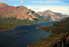
Waterton Lakes National Park is a national park located in the southwest corner of Alberta, Canada. It borders Glacier National Park in Montana, United States. Waterton was the fourth Canadian national park, formed in 1895 and named after Waterton Lake, in turn after the Victorian naturalist and conservationist Charles Waterton. Its range is between the Rocky Mountains and prairies. This park contains 505 km2 (195 sq mi) of rugged mountains and wilderness.

The Waterton-Glacier International Peace Park is the union of Waterton Lakes National Park in Canada and Glacier National Park in the United States. Both parks are declared Biosphere Reserves by UNESCO and their union as a World Heritage Site.

The Oldman River is a river in southern Alberta, Canada. It flows roughly west to east from the Rocky Mountains, through the communities of Fort Macleod, Lethbridge, and on to Grassy Lake, where it joins the Bow River to form the South Saskatchewan River, which eventually drains into the Hudson Bay.
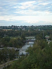
The Elbow River is a river in southern Alberta, Canada. It flows from the Canadian Rockies to the city of Calgary, where it merges into the Bow River.

The Prince of Wales Hotel is a historic hotel located in Waterton, Alberta, Canada. It is situated within Waterton Lakes National Park, overlooking Upper Waterton Lakes. It was designed by and built for the Great Northern Railway company. It is currently managed by the Pursuit Collection.

The Brazeau River is a river in western Alberta, Canada. It is a major tributary of the North Saskatchewan River.
Babb is a small unincorporated farming and ranching community in Glacier County, Montana, United States, on the Blackfeet Indian Reservation. The community experiences a large influx of tourists in the summer months as it is the gateway to the Many Glacier area of Glacier National Park. For statistical purposes, the United States Census Bureau has defined Babb as a census-designated place (CDP). It had a population of 174 at the 2010 census.

Belly River is a river in northwest Montana, United States and southern Alberta, Canada. It is a tributary of the Oldman River, itself a tributary of the South Saskatchewan River.
Under UNESCO’s Man and the Biosphere Programme, there are 308 biosphere reserves recognized as part of the World Network of Biosphere Reserves in Europe and North America. These are distributed across 41 countries in the region.

The following articles relate to the history, geography, geology, flora, fauna, structures and recreation in Glacier National Park (U.S.), the U.S. portion of the Waterton-Glacier International Peace Park.
Lake Sherburne Dam is a 107-foot (33 m) high compacted earthfill dam built between 1914 and 1921, just outside the boundary of Glacier National Park, Montana, its reservoir extending into the park. The dam impounds Swiftcurrent Creek as it flows out of the park. Water stored in Lake Sherburne is released to flow down Swiftcurrent Creek to the St. Mary River, from which it is diverted to the Milk River, flowing through Canada for 216 mi (348 km) before returning to the United States. Use of these waters is governed by the Boundary Waters Treaty of 1909. Water from the Milk River is used for irrigation in north central Montana.

The Whitesand River is a tributary of the Assiniboine River and finds its headwaters at Whitesand Lake near Invermay in east-central Saskatchewan. Its mouth can be found at its confluence with the Assiniboine River near Kamsack.

Waterton Biosphere Reserve is a UNESCO Biosphere Reserve encompassing Waterton Lakes National Park in the extreme south-west of the Province of Alberta, Canada. The reserve includes a section of the east slopes of the Rocky Mountains extending from the Continental Divide to the edge of the Canadian Great Plains to the east. The Glacier Biosphere Reserve and National Park in Montana, USA is located to the south of the area. The reserve is administered by Waterton Lakes National Park and the Waterton Biosphere Association.
Castle Wildland Provincial Park is a wildland provincial park in southern Alberta, Canada. The designation of the park was established on 20 January 2017, with an effective date of 16 February 2017. The designation involved the protection of 79,678 hectares of land. The park is included in the South Saskatchewan Region Land Use Framework. The park, along with Castle Provincial Park, is managed under the Castle Management Plan. The park takes its name from the region including the Castle River and Castle Peak of Windsor Mountain. Despite the name, it is not associated with Castle Mountain which is in Banff National Park.


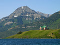 Upper Waterton Lake with Prince of Wales Hotel and Mount Richards
 Waterton Lake in winter
 49th parallel north at Waterton Lake
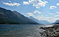 Looking south across Waterton Lake.


