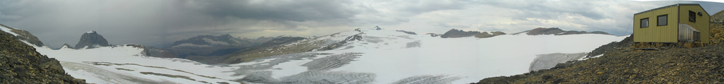
Waputik Icefield

Last updated
Skiing up the Waputik to Mt Balfour Skiing up the Waputik to Mt Balfour; Doug&Vic.jpg
Skiing up the Waputik to Mt Balfour

The Waputik Icefield is located on the Continental divide in the Canadian Rocky Mountains, in the provinces of British Columbia and Alberta. It is developed on the heights of the Waputik Range in the Central Main Ranges.

Contents

The icefield is shared by Banff and Yoho National Parks and numerous outlet glaciers extend from the icefield. Runoff from the Waputik Icefield provides water for numerous lakes, streams and rivers including Hector Lake, and the Bow, Kicking Horse and Yoho Rivers. Runoff from the Daly Glacier feeds Takakkaw Falls.

The icefield encompasses 40 km2 (15 miles²) and is located 20 km (12 mi) northwest of Lake Louise, on the west side of the Icefields Parkway.

The icefield is easily accessible by mountaineers in both the summer and winter. Both ski trips in the winter and glacier hiking trips in the summer often combine a traverse of this icefield with a trip across the Wapta Icefield directly to the north.

Glaciers

The following glaciers are part of this icefield:

Waputik icefield panorama by bryan birn 2005.jpg
A panoramic photo of the Waputik Icefield taken from the Scott Duncan Hut in 2005

Huts

There are two huts operated by the Alpine Club of Canada which are accessible from this icefield:

See also

Related Research Articles

<span class="mw-page-title-main">Yoho National Park</span> National park in British Columbia, Canada

Yoho National Park is a national park of Canada. It is located within the Rocky Mountains along the western slope of the Continental Divide of the Americas in southeastern British Columbia, bordered by Kootenay National Park to the south and Banff National Park to the east in Alberta. The word Yoho is a Cree expression of amazement or awe, and it is an apt description for the park's spectacular landscape of massive ice fields and mountain peaks, which rank among the highest in the Canadian Rockies.

<span class="mw-page-title-main">Banff National Park</span> National park in Alberta, Canada

Banff National Park is Canada's oldest national park, established in 1885 as Rocky Mountains Park. Located in Alberta's Rocky Mountains, 110–180 kilometres (68–112 mi) west of Calgary, Banff encompasses 6,641 square kilometres (2,564 sq mi) of mountainous terrain, with many glaciers and ice fields, dense coniferous forest, and alpine landscapes. The Icefields Parkway extends from Lake Louise, connecting to Jasper National Park in the north. Provincial forests and Yoho National Park are neighbours to the west, while Kootenay National Park is located to the south and Kananaskis Country to the southeast. The main commercial centre of the park is the town of Banff, in the Bow River valley.

<span class="mw-page-title-main">Peyto Peak</span> Mountain in Banff NP, Canada

Peyto Peak is a mountain in the Waputik Range, part of the Canadian Rockies in Alberta, Canada. It lies at the north end of the Wapta Icefield, in Banff National Park, about one km (0.6 mi) east of the border with British Columbia and 32 km (20 mi) north of the town of Field. Five kilometres to the northeast lies Bow Pass, one of the high points of the Icefields Parkway. Between the peak and the pass lies picturesque Peyto Lake. Three kilometres southwest of Peyto Peak is Mount Baker, the highest point in the immediate vicinity.

<span class="mw-page-title-main">Wapta Icefield</span> Glacier in Alberta and British Columbia, Canada

The Wapta Icefield is located on the Continental Divide in the Waputik Mountains of the Canadian Rockies, in the provinces of British Columbia and Alberta. The icefield is shared by Banff and Yoho National Parks and numerous outlet glaciers extend from the icefield, including the Vulture, Bow and Peyto Glaciers. Runoff from the icefields and outlet glaciers supply water to both the Kicking Horse and Bow Rivers, as well as numerous streams and lakes.

The Stanley Mitchell hut is an alpine hut located at an altitude of 2,060 metres (6,759 ft) in the Little Yoho Valley in Yoho National Park, British Columbia. It sits in a small meadow not far from the base of a mountain called The President. It serves as a base for hiking, scrambling, ski-touring and climbing the nearby mountains. The hut is maintained by the Alpine Club of Canada.

<span class="mw-page-title-main">Abbot Pass hut</span> Historic building in Alberta, Canada

The Abbot Pass hut was an alpine hut located at an altitude of 2,925 metres (9,596 ft) in Abbot Pass in the Rocky Mountains in Alberta, Canada. It was nestled between Mount Victoria and Mount Lefroy, straddling the Great Divide, which, in this region, defines the boundary between Banff National Park in Alberta and Yoho National Park in British Columbia. While close to the border, the hut lay entirely in Banff National Park, and was the second-highest permanently habitable structure in Canada. The hut was maintained by the Alpine Club of Canada.

<span class="mw-page-title-main">Bow Lake (Alberta)</span> Body of water

Bow Lake is a small lake in western Alberta, Canada. It is located on the Bow River, in the Canadian Rockies, at an altitude of 1920 m.

<span class="mw-page-title-main">Hector Lake</span> Body of water

Hector Lake is a small glacial lake in western Alberta, Canada. It is located on the Bow River, in the Waputik Range of the Canadian Rockies.

<span class="mw-page-title-main">Sherbrooke Lake (British Columbia)</span> Body of water

Sherbrooke Lake is a lake in Yoho National Park, British Columbia, Canada. The lake is bounded on the west by Mount Ogden 2,695 m (8,842 ft), Mount Niles 2,972 m (9,751 ft) to the north, and Paget Peak on the east side. The lake can be reached by following a three km hiking trail that begins from the Trans-Canada Highway across from Wapta Lake.

<span class="mw-page-title-main">Bow Hut</span> Alphine hut

The Bow Hut is an alpine hut located at an elevation of 2,350 metres (7,710 ft) on the eastern edge of the Wapta Icefield in Banff National Park. It is the largest, best equipped, and most accessible of the four alpine huts on the Wapta Icefield, and serves as the base for a wide variety of ski tours and mountaineering ascents to half a dozen peaks on the Wapta. It is the easiest and safest starting point for the Wapta traverse; and Balfour Hut, the next hut on the traverse, can easily be reached from it in a day. It can also serve as an intermediate stop in a longer traverse which starts at the less easily accessible Peyto Hut. The hut is maintained by the Alpine Club of Canada.

<span class="mw-page-title-main">R.J. Ritchie Hut</span> Alpine hut in Banff National Park, Canada

The R.J. Ritchie Hut is an alpine hut located at an altitude of 2,470 metres (8,100 ft) between the southern tip of the Wapta Icefield and the northern tip of the Waputik Icefield in Banff National Park. The hut is at the half-way mark for the Wapta traverse and is usually used in conjunction with the other huts in this chain while attempting a cross-glacier ski trip. The hut is maintained by the Alpine Club of Canada.

<span class="mw-page-title-main">Mount Balfour</span> Mountain in Canadian Rockies

Mount Balfour is a mountain located on the Continental Divide, part of the border between British Columbia and Alberta, in the Waputik Range in the Park Ranges of the Canadian Rockies.It is the 71st highest peak in Alberta and the 113th highest in British Columbia; it is also the 52nd most prominent in Alberta.

<span class="mw-page-title-main">Mont des Poilus</span>

Mont des Poilus is a 3,161-metre (10,371-foot) mountain summit located in Yoho National Park, in the Canadian Rockies of British Columbia, Canada. Its nearest higher peak is Mount Baker, 8.0 km (5.0 mi) to the north. Both are part of the Waputik Mountains.

<span class="mw-page-title-main">Waputik Mountains</span> Subrange of the Park Ranges in Alberta and British Columbia, Canada

The Waputik Mountains are a mountain range of the Canadian Rockies, located on the Continental Divide between Banff and Yoho National Park. Covering an area of 1,069 square kilometres (413 sq mi), the range is located west of the Howse, Blaeberry and Amiskwi Rivers and east of the Bow and Mistaya Rivers and south to Kicking Horse Pass. Named in 1884 by George M. Dawson, "waputik" is the Stoney Indian word for white goat.

<span class="mw-page-title-main">Mount Thompson (Alberta)</span> Mountain in Banff NP, Alberta, Canada

Mount Thompson is a 3,089-metre (10,135-foot) mountain summit located four kilometres west of Bow Lake in Banff National Park, in the Canadian Rockies of Alberta, Canada. Its nearest higher peak is Mount Baker, 5.0 km (3.1 mi) to the west. Mount Thompson is situated east of the Wapta Icefield, and is a member of the Waputik Mountains. Mount Thompson can be seen from the Icefields Parkway at Bow Lake.

<span class="mw-page-title-main">Michael Peak</span>

Michael Peak is a 2,701-metre (8,862-foot) mountain summit located in Yoho National Park, in the Canadian Rockies of British Columbia, Canada. Its nearest higher peak is The President, 4.0 km (2.5 mi) to the west-northwest. Both are part of the President Range which is a subset of the Waputik Mountains. Michael Peak is a landmark seen 4.5 kilometres north-northeast of Emerald Lake, three kilometres southwest of Takakkaw Falls, and 10 kilometres north of Field, British Columbia.

<span class="mw-page-title-main">Mount Niles</span> Mountain in Yoho NP, BC, Canada

Mount Niles is a 2,967-metre (9,734-foot) summit located in the Waputik Range of Yoho National Park, in the Canadian Rockies of British Columbia, Canada. The nearest higher peak is Mount Daly, 1.63 km (1.01 mi) to the immediate northeast. Takakkaw Falls is situated four km to the west, the Waputik Icefield lies to the north, and Sherbrooke Lake lies to the south. Precipitation runoff from Mount Niles drains into the Yoho River and Niles Creek, both tributaries of the Kicking Horse River. Topographic relief is significant as the summit rises approximately 1,500 meters (4,920 feet) above Yoho Valley in four kilometers (2.5 mile).

<span class="mw-page-title-main">Portal Peak</span> Mountain in Banff NP, Alberta, Canada

Portal Peak is a 2,926-metre (9,600-foot) mountain summit located four kilometers west of Bow Lake in Banff National Park, in the Canadian Rockies of Alberta, Canada. Its nearest higher peak is Mount Thompson, 1.0 km (0.62 mi) to the northwest. Portal Peak is situated east of the Wapta Icefield, and is a member of the Waputik Mountains. Portal Peak can be seen from the Icefields Parkway at Bow Lake.

<span class="mw-page-title-main">Parker Ridge</span> Mountain ridge in Banff NP, Alberta, Canada

Parker Ridge is a 2,255-metre (7,398-foot) mountain ridge located in the upper North Saskatchewan River valley in Banff National Park, in the Canadian Rockies of Alberta, Canada. Its nearest higher peak is Mount Athabasca, 7.7 km (4.8 mi) to the west. Parker Ridge is situated along the west side of the Icefields Parkway and southeast of Sunwapta Pass. Parker Ridge is a ski-touring destination in the winter and popular hiking destination in the summer because it is situated beside the Icefields Parkway allowing easy access, and is nearly entirely above treeline allowing good views of the surrounding mountain landscape. A 2.2 km (1.4 mi) trail gains 275 metres (900 ft) of elevation from the highway to the top of the ridge. Wandering east or west along the ridge provides views of Cirrus Mountain, the north face of Mount Saskatchewan, Saskatchewan Glacier, Mount Athabasca, Hilda Peak, and Nigel Peak among others.

References

Commons-logo.svg Media related to Waputik Icefield at Wikimedia Commons

Coordinates: 51°34′N116°27′W / 51.567°N 116.450°W / 51.567; -116.450