
The Smiths were an English rock band formed in Manchester in 1982, composed of Morrissey (vocals), Johnny Marr (guitar), Andy Rourke (bass) and Mike Joyce (drums). Morrissey and Marr formed the band’s songwriting partnership. The Smiths are regarded as one of the most important acts to emerge from 1980s British independent music.

John Martin Marr is an English musician, songwriter and singer. He first achieved fame as the guitarist and co-songwriter of the Smiths, who were active from 1982 to 1987. He has since performed with numerous other bands and embarked on a solo career.

Neil Anthony Morrissey is an English actor, businessman, narrator and presenter. He is known for his role as Tony in Men Behaving Badly. Other notable acting roles include Deputy Head Eddie Lawson in the BBC One school-based drama series Waterloo Road, Nigel Morton in Line of Duty, and Rocky in Boon. Morrissey also provided the voice of the titular character, Lofty, Roley, and others in Bob the Builder.

Suedehead: The Best of Morrissey is a compilation album by English singer Morrissey, released on 8 September 1997. It contains material released during Morrissey's EMI period.

Sinéad Morrissey is a Northern Irish poet. In January 2014 she won the T. S. Eliot Prize for her fifth collection Parallax and in 2017 she won the Forward Prize for Poetry for her sixth collection On Balance.

The Virginia Community College System (VCCS) oversees a network of 23 community colleges in Virginia, which serve residents of Virginia and provide two-year degrees and various specialty training and certifications. In 2006, the Virginia Community College System's annual enrollment rate topped 233,000 students. The VCCS also had an additional 170,000 students in workforce development services and noncredit courses.

The Hart Ranges are a major subrange of the Canadian Rockies located in northeastern British Columbia and western Alberta. The mountains constitute the southernmost portion of the Northern Rocky Mountains.
"Redondo Beach" is a song by Patti Smith. It was first released on Smith's 1975 album Horses, with band members Richard Sohl and Lenny Kaye credited as co-writers. The lyrics were originally published as a poem in Smith's 1972 book kodak under the title "Radando Beach".

Martin Morrissey is an Irish sports commentator and television presenter. He is the Gaelic games correspondent for RTÉ News and regularly presents high-profile sports events for RTÉ Sport, such as the All-Ireland Senior Football Championship and Olympic Games.

Joseph Dee Morrissey is an American Democratic politician, businessman, and former lawyer who won election to both chambers of the Virginia General Assembly from districts including Richmond or surrounding Henrico County, Virginia. He represented Virginia's 16th Senate district from 2020 to 2024, having been elected during the 2019 election. He represented much of southern Richmond, as well as all of the cities of Petersburg and Hopewell and portions of Chesterfield, Dinwiddie and Prince George counties. He lost the 2023 Democratic primary for his district.
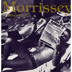
"Tomorrow" is a US-only single released by Morrissey in September 1992. It reached number one on Billboard magazine's Hot Modern Rock Tracks chart. It is a remix of the final track of Morrissey's Your Arsenal album of the same year.
The Rattlesnake Hills, also known as Rattlesnake Ridge, is a 16-mile (26 km) long anticline mountain ridge in Yakima County and Benton County in the U.S. state of Washington. It should not be confused with the much smaller Rattlesnake Ridge located near the west end of Ahtanum Ridge just south of Yakima, Washington and west of Union Gap, Washington. The highest point in the hills is the 3,629 feet (1,106 m) Lookout Summit, which surpasses the more well-known Rattlesnake Mountain by approximately 100 ft (30 m). The Rattlesnake Hills are part of the Yakima Fold Belt of east-tending long ridges formed by the folding of Miocene Columbia River basalt flows.

Morrissey Boulevard is a six-lane divided coastal road in the Dorchester neighborhood of Boston, Massachusetts, United States. It is owned and maintained by the Massachusetts Department of Conservation and Recreation (DCR).

Steven Patrick Morrissey, known mononymously as Morrissey, is an English singer and songwriter. He came to prominence as the frontman and lyricist of rock band the Smiths, who were active from 1982 to 1987. Since then, he has pursued a successful solo career. Morrissey's music is characterised by his baritone voice and distinctive lyrics with recurring themes of emotional isolation, sexual longing, self-deprecating and dark humour, and anti-establishment stances.

The Morrissey Formation is a stratigraphic unit of Late Jurassic (Portlandian) age in the Western Canada Sedimentary Basin. It is named for outcrops on Morrissey Ridge, 16 kilometres (10 mi) southeast of Fernie, British Columbia, and is present in southeastern British Columbia and southwestern Alberta.
Thomas Morrissey is an Irish hurler who plays as a left wing-forward for club side Ahane and at inter-county level with the Limerick senior hurling team.
Daniel Morrissey is an Irish hurler who plays as a left wing-back for club side Ahane and at inter-county level with the Limerick senior hurling team.
James David Morrissey IV is an American professional football center for the New York Giants of the National Football League (NFL). He played college football at Pittsburgh.
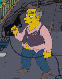
"Panic on the Streets of Springfield" is the 19th episode of the thirty-second season of the American animated television series The Simpsons, and the 703rd episode overall. It aired in the United States on Fox on April 18, 2021. The episode was directed by Matthew Nastuk, and written by Tim Long. In this episode, Lisa becomes obsessed with a cynical English singer named Quilloughby who becomes her imaginary friend.
Without Music the World Dies is the upcoming fourteenth solo studio album by English singer Morrissey.
