
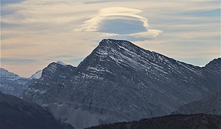
Mount Assiniboine, also known as Assiniboine Mountain, is a pyramidal peak mountain on the Great Divide, on the British Columbia/Alberta border in Canada.

Mount Columbia is a mountain located in the Winston Churchill Range of the Rocky Mountains. It is the highest point in Alberta, Canada, and is second only to Mount Robson for height and topographical prominence in the Canadian Rockies. It is located on the border between Alberta and British Columbia on the northern edge of the Columbia Icefield. Its highest point, however, lies within Jasper National Park in Alberta.

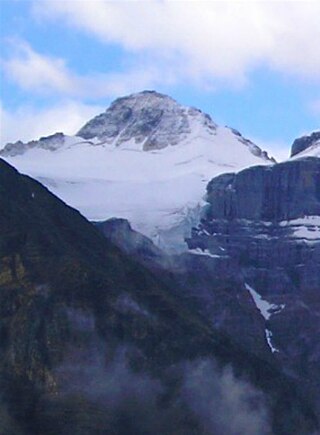
Mount Alberta is a mountain located in the upper Athabasca River Valley of Jasper National Park, Alberta, Canada. J. Norman Collie named the mountain in 1898 after Princess Louise Caroline Alberta. It is the most difficult of the 11,000ers from a climbing point of view.

Mount Forbes is the seventh tallest mountain in the Canadian Rockies and the tallest within the boundaries of Banff National Park. It is located in southwestern Alberta, 18 km (11 mi) southwest of the Saskatchewan River Crossing in Banff. The mountain was named by James Hector in 1859 after Edward Forbes, Hector's natural history professor at the University of Edinburgh during the mid-19th century.

Mount Hector is a 3,394-metre (11,135-foot) mountain summit located in the Bow River valley of Banff National Park, in the Canadian Rockies of Alberta, Canada. The mountain was named in 1884 by George M. Dawson after James Hector, a geologist on the Palliser expedition. The mountain is located beside the Icefields Parkway, 17 km (11 mi) north of Lake Louise.

Nordegg is a hamlet in west-central Alberta, Canada within Clearwater County. It is in the North Saskatchewan River valley in the foothills of the Canadian Rockies, just east of the intersection of the David Thompson Highway and the Highway 734 spur of the Bighorn Highway. A former coal mining town, it was named after Martin Nordegg and the name probably means "North Corner" in a German dialect. The railway station name at the locality was called Brazeau rather than Nordegg at certain points in its history, but the local post office has always been named Nordegg. The name Brazeau is now obsolete.

The Brazeau River is a river in western Alberta, Canada. It is a major tributary of the North Saskatchewan River.
Mount Bishop is a mountain named in 1918 after W.A. "Billy" Bishop VC who was a Colonel and a Canadian fighter pilot awarded the Victoria Cross during World War I. It is located in the Elk Range of the Canadian Rockies and sits on the Continental Divide, which forms the British Columbia-Alberta border in this area.

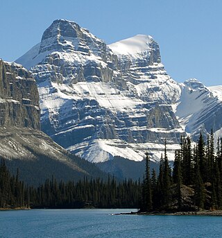
Mount Unwin is a 3,268-metre (10,722-foot) mountain summit located on the west side of Maligne Lake in Jasper National Park, in the Queen Elizabeth Range of the Canadian Rockies of Alberta, Canada. Its nearest higher peak is Mount Brazeau, 13.0 km (8.1 mi) to the east-southeast.

The Park Ranges, also known as the Main Ranges, are a group of mountain ranges in the Canadian Rockies of southeastern British Columbia and southwestern Alberta, Canada. It is one of the three main subranges and the most central of the Continental Ranges, extending from southeast of Mount McGregor to the Fernie Basin.
Mount Ulysses, is the highest mountain in the Muskwa Ranges of the Northern Canadian Rockies in British Columbia. It and neighbouring peaks are part of a group of names drawing on the epic poem The Odyssey, in which here Ulysses wanders for 10 years before being able to return home to Ithaca.
Mount O'Beirne is a mountain in the Continental Ranges on the border of Alberta and British Columbia. It is Alberta's 59th most prominent mountain. It was named in 1918 by Arthur Oliver Wheeler after Eugene Francis O'Beirne, a "sponger and general pest" who in 1864 had attached himself to William Wentworth-FitzWilliam, Viscount Milton and Walter Butler Cheadle's expedition over the Yellowhead Pass.
Dungeon Peak is a 3,129-metre (10,266 ft) mountain summit located on the shared border of Jasper National Park in Alberta, and Mount Robson Provincial Park in British Columbia, Canada. Dungeon Peak is part of The Ramparts in the Tonquin Valley. The descriptive name was applied in 1916 by Morrison P. Bridgland (1878-1948), a Dominion Land Surveyor who named many peaks in Jasper Park and the Canadian Rockies. The mountain's name was made official in 1935 by the Geographical Names Board of Canada.
Mount Barnard is located on the border of Alberta and British Columbia, NW of the head of Waitabit Creek and North of Golden. It is the 30th highest peak in Alberta and the 42nd highest peak in British Columbia. It was named in 1917 by boundary surveyors after Sir Francis Stillman Barnard, a Lieutenant Governor of BC during the 1910s. It should not be confused with the higher Californian peak of the same name.
Mount Barlow is located on the Continental Divide along the border of Alberta and British Columbia at the southern edge of the Freshfield Icefield in Banff National Park. It was named in 1916 by D.B. Dowling after Dr. Alfred Ernest Barlow, a cartographer with the Geological Survey of Canada who died in the 1914 Empress of Ireland disaster.

Mount Olive is located N of the head of the Yoho River on the Continental Divide, on the Alberta-British Columbia border, in both Banff National Park and Yoho National Park. It lies on the eastern edge of the Wapta Icefield, and is part of the Waputik Mountains. It was named in 1898 by H.B. Dixon after his wife Dixon, Olive.
Mount Little is situated at the northern end of Kootenay National Park, and straddles the Continental Divide marking the Alberta-British Columbia border. It was named in 1916 after George F. Little, a member of the first ascent party.

Mount Beatty is a mountain located on the border of Alberta and British Columbia on the Continental Divide. It was named in 1924 after David Beatty, a British naval officer of Irish ancestry who commanded ships in the First World War.
Mount Warren is a 3,362-metre (11,030-foot) mountain summit located at the southeast end of Maligne Lake in Jasper National Park, in the Canadian Rockies of Alberta, Canada. Mount Warren is often seen in the background of iconic calendar photos of Spirit Island and Maligne Lake. The mountain rises 1,690 metres (5,540 ft) in less than 4 kilometres (2.5 mi) from the lake giving it dramatic local relief. Mount Warren is situated at the northwest edge of the Brazeau Icefield, and its nearest higher peak is Mount Brazeau, 2.26 kilometres to the southeast. Monkhead is a lower secondary summit to the northwest of the true summit.

