
Mount Waddington, once known as Mystery Mountain, is the highest peak in the Coast Mountains of British Columbia, Canada. Although it is lower than Mount Fairweather and Mount Quincy Adams, which straddle the United States border between Alaska and British Columbia, Mount Waddington is the highest peak that lies entirely within British Columbia. It and the subrange which surround it, known as the Waddington Range, stand at the heart of the Pacific Ranges, a remote and extremely rugged set of mountains and river valleys.

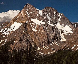
Mount Robson is the most prominent mountain in North America's Rocky Mountain range; it is also the highest point in the Canadian Rockies. The mountain is located entirely within Mount Robson Provincial Park of British Columbia, and is part of the Rainbow Range. Mount Robson is the second highest peak entirely in British Columbia, behind Mount Waddington in the Coast Range. The south face of Mount Robson is clearly visible from the Yellowhead Highway, and is commonly photographed along this route.

Mount Columbia is a mountain located in the Winston Churchill Range of the Rocky Mountains. It is the highest point in Alberta, Canada, and is second only to Mount Robson for height and topographical prominence in the Canadian Rockies. It is located on the border between Alberta and British Columbia on the northern edge of the Columbia Icefield. Its highest point, however, lies within Jasper National Park in Alberta.

Mount Robson Provincial Park is a provincial park in the Canadian Rockies with an area of 2,249 km2. The park is located entirely within British Columbia, bordering Jasper National Park in Alberta. The B.C. legislature created the park in 1913, the same year as the first ascent of Mount Robson by a party led by Conrad Kain. It is the second oldest park in the provincial system. The park is named for Mount Robson, which has the highest point in the Canadian Rockies and is located entirely within the park.
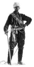
Conrad Kain was an Austrian mountain guide who guided extensively in Europe, Canada, and New Zealand, and was responsible for the first ascents of more than 60 routes in British Columbia. He is particularly known for pioneering climbs in the Purcell Mountains and the first ascents of Mount Robson (1913), Mount Louis (1916) and Bugaboo Spire (1916).
Mount Kain is a mountain located in the Fraser River Valley of Mount Robson Provincial Park, Canada. Mt. Kain was named during a survey of the Mt. Robson region conducted by the Alpine Club of Canada during the summer of 1911. While surveying from a nearby peak, the party noticed the mountain and guide Conrad Kain exclaimed "Ach! That is my peak." Trip leader Arthur Oliver Wheeler recorded the peak as Mt. Kain.

Mount Saint Elias, the second-highest mountain in both Canada and the United States, stands on the Yukon and Alaska border about 26 miles (42 km) southwest of Mount Logan, the highest mountain in Canada. The Canadian side of Mount Saint Elias forms part of Kluane National Park and Reserve, while the U.S. side of the mountain is located within Wrangell-St. Elias National Park and Preserve.

North Twin (Peak) is one of the two main peaks that comprise The Twins massif located at the northeast corner of the Columbia Icefield in Jasper National Park, Alberta, Canada. The other lower peak is named South Twin (3,566 m). North Twin is the third-highest peak in the Canadian Rockies, after Mount Robson and Mount Columbia.

The Columbia Icefield is the largest ice field in North America's Rocky Mountains. Located within the Canadian Rocky Mountains astride the Continental Divide along the border of British Columbia and Alberta, Canada, the ice field lies partly in the northwestern tip of Banff National Park and partly in the southern end of Jasper National Park. It is about 325 square kilometres (125 sq mi) in area, 100 to 365 metres in depth and receives up to 7 metres (280 in) of snowfall per year.

The Bugaboos are a mountain range in the Purcell Mountains of eastern British Columbia, Canada. The granite spires of the group are a popular mountaineering destination. The Bugaboos are protected within Bugaboo Provincial Park.

Mount Balfour is a mountain located on the Continental Divide, part of the border between British Columbia and Alberta, in the Waputik Range in the Park Ranges of the Canadian Rockies. It is the 71st highest peak in Alberta and the 113th highest in British Columbia; it is also the 52nd most prominent in Alberta.

Whitehorn Mountain is a 3,399-metre (11,152 ft) peak located in eastern British Columbia, Canada near the Alberta border. It is one of British Columbia's 102 ultra prominent peaks.
Donald Nelson "Curly" Phillips (1884-1938) was a Canadian guide, outfitter, entrepreneur, and explorer who was a part of many pioneering expeditions in the northern Canadian Rockies in the early twentieth century. He settled in Jasper, Alberta, and was involved in the development of mountain tourism in the region.
Peter Kaufmann-Bohren was born on June 23, 1886, in Grindelwald, and he died on June 23, 1971, in Thun, at the age of 85. Peter was a Swiss ski instructor and mountain guide, climbing in the Swiss Alps and the Canadian Rockies.

Rearguard Mountain is a 2,744-metre (9,003-foot) summit located within Mount Robson Provincial Park in British Columbia, Canada. It is part of the Rainbow Range which is a sub-range of the Canadian Rockies. Its nearest higher peak is Mount Robson, 4.0 km (2.5 mi) to the southwest. Rearguard is situated between Berg Lake and the Robson Glacier.

Mount Geikie, pronounced like "geeky", is a 3,298-metre (10,820-foot) mountain summit located in Mount Robson Provincial Park in British Columbia, Canada. Situated 28 km (17 mi) southwest of Jasper near the Tonquin Valley, Mount Geikie is the highest peak of The Ramparts in the Canadian Rockies, one of the most beautiful mountain meccas in the world. Its nearest higher peak is Mount Fraser, 8.0 km (5.0 mi) to the southeast, and the Continental Divide lies 3.0 km (1.9 mi) to the east. Mount Geikie is composed of quartzite of the Cambrian period. This rock was pushed east and over the top of younger rock during the Laramide orogeny. The vertical wall of its north face is over 1,500-metre (4,900-foot) high, and has been compared to the other great north faces of the Canadian Rockies such as North Twin, Alberta, and Kitchener.
Jumbo Mountain, sometimes called Mount Jumbo, is a 3,437-metre-elevation (11,276-foot) mountain summit located 42 km (26 mi) west-southwest of Invermere in the Purcell Mountains of southeast British Columbia, Canada. The nearest higher peak is Mount Farnham, 11 km (6.8 mi) to the north-northeast, and Karnak Mountain is set 0.79 km (0.49 mi) to the west. Jumbo and Karnak form a double summit massif which is the second-highest mountain in the Purcells, and fourth-highest in the Columbia Mountains. The first ascent of Jumbo Mountain was made August 4, 1915, by H.O. Frind, A.H. & E.L. MacCarthy, M & W.E. Stone, B. Shultz, and Conrad Kain via the North/Northeast Slopes. March 5, 1919, Conrad made a solo ascent of Jumbo Mtn on snowshoes - credited as the first winter ascent of an 11,000-ft peak in Canada. The peak was named by Edward Warren Harnden after the 1892 Jumbo Mineral Claim on nearby Toby Creek, which in turn was named for Jumbo the elephant. The mountain's toponym was officially adopted March 31, 1924, when approved by the Geographical Names Board of Canada.

Taurus Mountain is a mountain summit located in British Columbia, Canada.

Mount Anne-Alice is a mountain summit in the Canadian Rockies of British Columbia, Canada.
Mount Conrad is a 3,279-metre (10,758-foot) mountain summit in British Columbia, Canada.


