
Mount Robson is the most prominent mountain in North America's Rocky Mountain range; it is also the highest point in the Canadian Rockies. The mountain is located entirely within Mount Robson Provincial Park of British Columbia, and is part of the Rainbow Range. Mount Robson is the second highest peak entirely in British Columbia, behind Mount Waddington in the Coast Range. The south face of Mount Robson is clearly visible from the Yellowhead Highway, and is commonly photographed along this route.

Mount Edith Cavell is a mountain in the Athabasca River and Astoria River valleys of Jasper National Park, and the most prominent peak entirely within Alberta.

The Winston Churchill Range is a mountain range in the central section of the Park Ranges of the Canadian Rockies located in Jasper National Park. The range was named after Sir Winston Churchill, former British prime minister.

The Queen Elizabeth Ranges is a group of mountain ranges in the Canadian Rockies on the southeastern side of Jasper National Park, Canada. The northern end of the ranges begins east of Medicine Lake and extends in a southeasterly direction past the southern shore of Maligne Lake. The group was named in 1953 to celebrate the coronation of Elizabeth II as Canada's sovereign.

The Blue Range is a mountain range of the Canadian Rockies, located on the Continental Divide in Banff National Park, Canada. The range was so named on account of its blueish colour when viewed from afar. Mount Alcantara is the highest point in the range.

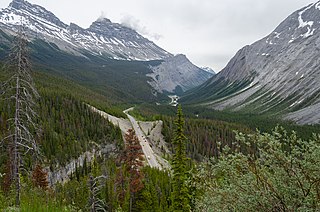
The Rainbow Range is a small subrange of the Park Ranges subdivisions of the Northern Continental Ranges of the Rocky Mountains on the border between Alberta and British Columbia in Mount Robson Provincial Park.
Highway 93 is a north–south highway in Alberta, Canada. It is also known as the Banff-Windermere Parkway south of the Trans-Canada Highway and the Icefields Parkway north of the Trans-Canada Highway. It travels through Banff National Park and Jasper National Park and is maintained by Parks Canada for its entire length. It runs from the British Columbia border at Vermilion Pass in the south, where it becomes British Columbia Highway 93, to its terminus at the junction with the Yellowhead Highway at Jasper. The route takes its number from U.S. Route 93, which runs uninterrupted south to central Arizona, and was initially designated as '93' in 1959.

The Premier Range is a group of mountains within the Cariboo Mountains of east-central British Columbia, Canada. The range is bounded by the Raush River and Kiwa Creek to the north, the North Thompson River on the south and west and the Fraser River and its tributaries to the east.

The Maligne Range is a mountain range of the Canadian Rockies located directly southeast of Jasper townsite in Jasper National Park, Canada. The southern tail-end of the range finishes at Endless Chain Ridge.

The Bow Range is a mountain range of the Park Ranges in Alberta and British Columbia, Canada. The range is named in association with the Bow River and was officially adopted on March 31, 1917 by the Geographic Board of Canada.

The High Rock Range is a mountain range of the Canadian Rockies in southwestern Alberta and southeastern British Columbia, Canada.
The Tower of London Range is a sub-range of the Northern Rocky Mountains in northern British Columbia, Canada, located northwest of the Tuchodi Lakes at the northwest end of the Northern Rocky Mountains Provincial Park to the southwest of Fort Nelson.

The Whistlers is a 2,470-metre (8,100-foot) mountain summit located in Jasper National Park, in the Trident Range of the Canadian Rockies of Alberta, Canada. The municipality of Jasper is situated 7 kilometres to the northeast. The nearest higher neighbor is Indian Peak, 2.5 km (1.6 mi) to the southwest. The highest and longest aerial tramway in Canada ascends to a lookout at 2,277 meters elevation, still 193 meters below the summit, but a hiking trail continues to the summit. Some of the mountains that can be seen from the top include Mount Robson, Mount Bridgland, Monarch Mountain, Cairngorm, Pyramid Mountain, Hawk Mountain, Mount Colin, Grisette Mountain, Mount Tekarra, Mount Hardisty, Mount Kerkeslin, Marmot Mountain, Terminal Mountain, and Manx Peak.

Manx Peak is a 3,044-metre (9,987 ft) mountain summit located in Jasper National Park, in the Trident Range of the Canadian Rockies of Alberta, Canada. The town of Jasper is situated 14 kilometres (8.7 mi) to the north-northeast. Circus Valley lies at the south side of the mountain, and the northeast aspect towers above the head of the valley of Whistlers Creek. Its nearest higher peak is Mount Estella, 1.8 km (1.1 mi) to the southwest, and Terminal Mountain lies 2.0 km (1.2 mi) to the east. The peak is composed of sedimentary rock laid down from the Precambrian to the Jurassic periods and pushed east and over the top of younger rock during the Laramide orogeny.

Murray Range is a subdivision range of the Hart Ranges, of the Northern Rockies in British Columbia, Canada. The majority of the range lies within the Pine-Lemoray Provincial Park and is noted for its snowmobiling, hiking and ski touring opportunities. The boundaries of the Murray Range generally lie between the Misinchinka River to the west and Mountain Creek to the east; the Pine River to the north and Mount Reynolds to the south.
Solitude Range is a subdivision range of the Hart Ranges, of the Northern Rockies in British Columbia, Canada. The boundaries of the Solitude Range generally lie between the Murray Range and Mountain Creek to the west, Le Moray Creek to the east, the Pine River to the north and Mount Merrick to the south.

Throne Mountain is a prominent 3,120-metre (10,236 ft) mountain summit located in Jasper National Park, in the South Jasper Ranges of the Canadian Rockies of Alberta, Canada. It is situated 24 kilometres (15 mi) south of the town of Jasper, and 8 kilometres (5.0 mi) east of Tonquin Valley. The nearest higher neighbor is Mount Edith Cavell, 5.8 km (3.6 mi) to the east, and Franchère Peak lies 7.0 km (4.3 mi) to the northeast. The peak is composed of sedimentary rock laid down from the Precambrian to the Jurassic periods, that was pushed east and over the top of younger rock during the Laramide orogeny.

The Flathead Range is a mountain range of the Canadian Rockies in Alberta and British Columbia, Canada. It is located on the Continental Divide, east of Fernie, in the Kootenay Land District. It stretches 27 km (17 mi) lengthwise north–south from Crowsnest Pass to North Kootenay Pass. The range's toponym was officially adopted on 30 June 1912 by the Geographic Board of Canada, and was named in association with the Flathead River.

Marmot Mountain is a 2,608-metre (8,556-foot) mountain summit located in Alberta, Canada.

