Mount Estella

Last updated
Mount Estella
Mount Estella.jpg
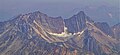
Southeast aspect, from Mt. Edith Cavell
Highest point
Elevation 3,069 m (10,069 ft) [1] [2]
Prominence 179 m (587 ft) [3]
Parent peak Majestic Mountain (3,086 m) [2]
Isolation 1.08 km (0.67 mi) [3]
Listing Mountains of Alberta
Coordinates 52°46′01″N118°12′41″W / 52.76694°N 118.21139°W / 52.76694; -118.21139 [4]
Geography
Canada Alberta relief location map - transverse mercator proj.svg
Red triangle with thick white border.svg
Mount Estella
Location of Mount Estella in Alberta
Canada relief map 2.svg
Red triangle with thick white border.svg
Mount Estella
Mount Estella (Canada)
Country Canada
Province Alberta
Protected area Jasper National Park
Parent range Canadian Rockies
Trident Range [3]
Topo map NTS 83D16 Jasper [4]
Geology
Age of rock Cambrian
Type of rock Sedimentary rock
Climbing
First ascent 1930, N.D. Waffl

Mount Estella is a 3,069-metre (10,069-foot) mountain summit in Alberta, Canada.

Contents

Description

Mount Estella is located within Jasper National Park and is the second-highest peak in the Trident Range of the Canadian Rockies. [3] The town of Jasper is situated 16 kilometres (9.9 mi) to the northeast and the Continental Divide is 11 kilometres (6.8 mi) to the west. The nearest higher neighbor is Majestic Mountain, 1.08 km (0.67 mi) to the south. [3] Precipitation runoff from Estella's east slope drains to the Athabasca River via Portal Creek and the west slope drains to the Miette River via Crescent and Meadow creeks. Topographic relief is significant as the summit rises 1,100 metres (3,609 feet) above Circus Valley in two kilometres (1.2 mile).

Majestic Mountain (left) and Mount Estella (right) Majestic and Estella.jpg
Majestic Mountain (left) and Mount Estella (right)

History

The mountain's name first appeared in 1916 when Morrison P. Bridgland, a Dominion Land Surveyor was naming many peaks in this area, but the namesake was not recorded. [5] [6] The name appeared in publications as early as 1917. [7] The mountain's toponym was officially adopted in 1951 by the Geographical Names Board of Canada. [4]

The first ascent of the summit was made in 1930 by Newman Diefendorf Waffl. [8] He would perish later that same year on Mount Robson.

Geology

The mountain is composed of sedimentary rock laid down during the Precambrian to Jurassic periods and pushed east and over the top of younger rock during the Laramide orogeny. [9] The strata of this peak have been tilted from horizonal orientation to nearly vertical.

Climate

Based on the Köppen climate classification, Mt. Estella is located in a subarctic climate zone with cold, snowy winters, and mild summers. [10] Winter temperatures can drop below -20 °C with wind chill factors below -30 °C.

See also

Related Research Articles

<span class="mw-page-title-main">Mount Bridgland</span> Mountain in the country of Canada

Mount Bridgland is a 2,930-metre (9,610 ft) mountain located in the Victoria Cross Ranges of Jasper National Park in Alberta, Canada. It was named by Frank Sissons in 1923 after Morrison P. Bridgland (1878-1948), a Dominion Land Surveyor who named many peaks in Jasper Park and the Canadian Rockies.

Amber Mountain is a 2,565-metre (8,415-foot) mountain summit located in the Maligne Range of Jasper National Park, in the Canadian Rockies of Alberta, Canada. Amber Mountain was so named on account of amber-hued shale outcroppings. The mountain was named in 1916 by Morrison P. Bridgland (1878-1948), a Dominion Land Surveyor who named many peaks in Jasper Park and the Canadian Rockies. The mountain's name was officially adopted in 1947 when approved by the Geographical Names Board of Canada. Its nearest higher peak is The Watchtower, 5.0 km (3.1 mi) to the east. Amber Mountain is composed of sedimentary rock laid down during the Cambrian period and pushed east and over the top of younger rock during the Laramide orogeny.

<span class="mw-page-title-main">Chetamon Mountain</span> Mountain in the country of Canada

Chetamon Mountain is a 2,606-metre (8,550-foot) mountain summit located in Jasper National Park, in the De Smet Range of the Canadian Rockies in Alberta, Canada. The peak is situated 18 kilometres (11 mi) north of the municipality of Jasper, in the Athabasca Valley and is visible from Highway 16 and the Canadian. Its nearest higher peak is Cliff Mountain, 3.5 km (2.2 mi) to the northwest.

Coronach Mountain is a 2,462-metre (8,077 ft) mountain summit located in Jasper National Park of Alberta, Canada. It is situated in the Bosche Range of the Canadian Rockies. The mountain was named in 1916 by Morrison P. Bridgland, who was inspired by the howling of nearby coyotes and applied the name Coronach, the Scottish Gaelic word for funeral dirge. Bridgland (1878-1948) was a Dominion Land Surveyor who named many peaks in Jasper Park and the Canadian Rockies. The mountain's name was officially adopted in 1956 by the Geographical Names Board of Canada. Its nearest higher peak is Mount Aeolus, 3.5 km (2.2 mi) to the north.

Mount Cumnock is a 2,438 m (7,999 ft) mountain summit located in Jasper National Park of Alberta, Canada. It is situated in the De Smet Range of the Canadian Rockies. Mount Cumnock was named in 1916 by Morrison P. Bridgland after Cumnock, in Scotland. Bridgland (1878-1948) was a Dominion Land Surveyor who named many peaks in Jasper Park and the Canadian Rockies. The mountain's name was officially adopted in 1956 by the Geographical Names Board of Canada. Its nearest higher peak is Mount Haultain, 7.5 km (4.7 mi) to the west.

<span class="mw-page-title-main">Curator Mountain</span> Mountain in the country of Canada

Curator Mountain is a 2,624-metre (8,609-foot) mountain summit located in the Maligne Range of Jasper National Park, in the Canadian Rockies of Alberta, Canada. Curator Mountain was so named on account of its central location, as if it were the "custodian" of Shovel Pass. The mountain was named in 1916 by Morrison P. Bridgland (1878-1948), a Dominion Land Surveyor who named many peaks in Jasper Park and the Canadian Rockies. The mountain's name was officially adopted in 1947 when approved by the Geographical Names Board of Canada. Its nearest higher peak is Trowel Peak, 7.7 km (4.8 mi) to the southeast. Curator Mountain is composed of sedimentary rock laid down during the Cambrian period and pushed east and over the top of younger rock during the Laramide orogeny.

<span class="mw-page-title-main">Mount Greenock</span> Mountain in Jasper NP, Alberta, Canada

Mount Greenock is a 2,073-metre (6,801 ft) mountain summit located in the Athabasca River valley of Jasper National Park in Alberta, Canada. It is situated in the De Smet Range of the Canadian Rockies. It was named in 1916 by Morrison P. Bridgland after Greenock, in Scotland. Bridgland (1878-1948) was a Dominion Land Surveyor who named many peaks in Jasper Park and the Canadian Rockies. The mountain's name was officially adopted in 1956 by the Geographical Names Board of Canada.

<span class="mw-page-title-main">Grisette Mountain</span> Mountain in Jasper National Park, Alberta, Canada

Grisette Mountain is a 2,620-metre (8,600 ft) mountain summit located in Jasper National Park in Alberta, Canada. It is located in the Colin Range, which is a sub-range of the Canadian Rockies. The peak is situated 14 km (8.7 mi) northeast of the municipality of Jasper, and is a prominent landmark in the Athabasca Valley visible from Highway 16 and the Canadian. Its nearest higher peak is Mount Dromore, 2.4 km (1.5 mi) to the east.

<span class="mw-page-title-main">Terminal Mountain</span> Mountain in Alberta, Canada

Terminal Mountain is a 2,835-metre (9,301 ft) mountain summit located in Jasper National Park, in the Trident Range of the Canadian Rockies of Alberta, Canada. The town of Jasper is situated 12 kilometers to the north-northeast. Terminal Mountain forms the west buttress of Marmot Pass, and the east buttress is formed by Marmot Mountain, home of the Marmot Basin alpine ski area. Peveril Peak rises to the south across Circus Valley, and the north side towers above the valley of Whistlers Creek. The nearest higher neighbor is Manx Peak, 2.0 km (1.2 mi) to the west.

<span class="mw-page-title-main">Mount Tekarra</span> Mountain in the country of Canada

Mount Tekarra is a 2,694-metre (8,839-foot) mountain summit located in the Athabasca River valley of Jasper National Park, in the Canadian Rockies of Alberta, Canada. It is situated at the northwest end of the Maligne Range and is visible from Jasper and the Icefields Parkway. The nearest higher neighbor is The Watchtower, 7.0 km (4.3 mi) to the east.

<span class="mw-page-title-main">Hawk Mountain (Alberta)</span> Mountain in the country of Canada

Hawk Mountain is a 2,553-metre (8,376-foot) mountain summit located in Jasper National Park in Alberta, Canada. It is located near the northwest end of the Colin Range, which is a sub-range of the Canadian Rockies. The peak is situated 16 km (9.9 mi) northeast of the municipality of Jasper, and is a prominent landmark in the Athabasca Valley visible from Highway 16 and the Canadian. Its nearest higher peak is Mount Colin, 2.4 km (1.5 mi) to the southeast. Hawk Mountain was named in 1916 by Morrison P. Bridgland for the fact that a hawk was flying near the summit at the time it was named. Bridgland (1878-1948) was a Dominion Land Surveyor who named many peaks in Jasper Park and the Canadian Rockies. The mountain's name was officially adopted in 1956 by the Geographical Names Board of Canada.

<span class="mw-page-title-main">Manx Peak</span> Mountain in Alberta, Canada

Manx Peak is a 3,044-metre (9,987 ft) mountain summit located in Jasper National Park, in the Trident Range of the Canadian Rockies of Alberta, Canada. The town of Jasper is situated 14 kilometres (8.7 mi) to the north-northeast. Circus Valley lies at the south side of the mountain, and the northeast aspect towers above the head of the valley of Whistlers Creek. Its nearest higher peak is Mount Estella, 1.8 km (1.1 mi) to the southwest, and Terminal Mountain lies 2.0 km (1.2 mi) to the east. The peak is composed of sedimentary rock laid down from the Precambrian to the Jurassic periods and pushed east and over the top of younger rock during the Laramide orogeny.

<span class="mw-page-title-main">Mount Erebus (Canada)</span> Mountain in the country of Canada

Mount Erebus is a 3,112-metre (10,210-foot) mountain summit located near one of the most beautiful mountain meccas in the world, the Tonquin Valley of Jasper National Park in Alberta, Canada. Mount Erebus is composed of sedimentary rock laid down during the Cambrian period, then was pushed east and over the top of younger rock during the Laramide orogeny. Its nearest higher peak is Mount Fraser, 4.0 km (2.5 mi) to the northwest. The Continental Divide lies 3 km (1.9 mi) to the west, Angle Peak is situated 4.5 km (2.8 mi) to the southeast, and The Ramparts are 5.0 km (3.1 mi) to the north. The mountain's north ridge terminates at Outpost Peak.

<span class="mw-page-title-main">Indian Ridge (Alberta)</span> Mountain in Alberta, Canada

Indian Ridge is a 2,820-metre (9,252 ft) mountain located in Jasper National Park, in the Trident Range of the Canadian Rockies of Alberta, Canada. The summit is unofficially called Indian Peak. The town of Jasper is situated 9 kilometres (5.6 mi) to the north-northeast, The Whistlers lies 2.55 kilometres (1.58 mi) to the northeast, and Muhigan Mountain is 4.8 kilometres (3.0 mi) to the west-northwest. The nearest higher peak is Manx Peak, 4.3 km (2.7 mi) to the southwest, and Terminal Mountain lies 3.25 km (2.02 mi) to the south. The Marmot Basin alpine ski area on Marmot Mountain is located 4 kilometres (2.5 mi) to the southeast. The peak is composed of sedimentary rock laid down from the Precambrian to the Jurassic periods and pushed east and over the top of younger rock during the Laramide orogeny.

<span class="mw-page-title-main">Throne Mountain</span> Mountain in the country of Canada

Throne Mountain is a prominent 3,120-metre (10,236 ft) mountain summit located in Jasper National Park, in the South Jasper Ranges of the Canadian Rockies of Alberta, Canada. It is situated 24 kilometres (15 mi) south of the town of Jasper, and 8 kilometres (5.0 mi) east of Tonquin Valley. The nearest higher neighbor is Mount Edith Cavell, 5.8 km (3.6 mi) to the east, and Franchère Peak lies 7.0 km (4.3 mi) to the northeast. The peak is composed of sedimentary rock laid down from the Precambrian to the Jurassic periods, that was pushed east and over the top of younger rock during the Laramide orogeny.

<span class="mw-page-title-main">Cairngorm (Alberta)</span> Mountain in the country of Canada

Cairngorm is a 2,610-metre (8,563 ft) mountain located in Alberta, Canada.

<span class="mw-page-title-main">Lectern Peak</span> Mountain in the country of Canada

Lectern Peak is a 2,772-metre (9,094-foot) mountain summit located in Alberta, Canada.

<span class="mw-page-title-main">Roche Noire (Alberta)</span> Mountain in the country of Canada

Roche Noire is a 2,920-metre (9,580 ft) mountain located in Alberta, Canada.

<span class="mw-page-title-main">Blackhorn Peak</span>

Blackhorn Peak is a 3,000-metre (9,800-foot) summit in Alberta, Canada.

<span class="mw-page-title-main">Majestic Mountain (Alberta)</span>

Majestic Mountain is a 3,086-metre (10,125-foot) summit in Alberta, Canada.

References

  1. Putnam, William Lowell (1974). Climber's Guide to the Rocky Mountains of Canada--north. American Alpine Club. p. 214. ISBN   9780930410025.
  2. 1 2 "Mount Estella". peakvisor.com. Retrieved 2023-08-03.
  3. 1 2 3 4 5 "Mount Estella, Alberta". Peakbagger.com. Retrieved 2023-08-03.
  4. 1 2 3 "Mount Estella". Geographical Names Data Base . Natural Resources Canada . Retrieved 2023-08-03.
  5. MacLaren, I.S. (2005). Mapper of Mountains M.P. Bridgland in the Canadian Rockies 1902-1930. With Eric Higgs, Gabrielle Zezulka-Mailloux. Edmonton, AB: The University of Alberta Press. ISBN   0-88864-456-6.
  6. Aubrey, Merrily (2006). Concise Place Names of Alberta. University of Calgary Press. p. 108. ISBN   9781552382103.
  7. Bridgland, Morrison Parsons (1917). Description of & Guide to Jasper Park. Department of the Interior. p. 89.
  8. "Mount Estella". cdnrockiesdatabases.ca. Retrieved 2023-08-03.
  9. Gadd, Ben (2008), Geology of the Rocky Mountains and Columbias
  10. Peel, M. C.; Finlayson, B. L.; McMahon, T. A. (2007). "Updated world map of the Köppen−Geiger climate classification". Hydrol. Earth Syst. Sci. 11: 1633–1644. ISSN   1027-5606.