Jasper National Park is a national park in Alberta, Canada. It is the largest national park within Alberta's Rocky Mountains spanning 11,000 km2 (4,200 sq mi). It was established as a national park in 1930 and declared a UNESCO World Heritage Site in 1984. Its location is north of Banff National Park and west of Edmonton. The park contains the glaciers of the Columbia Icefield, springs, lakes, waterfalls and mountains.

Kootenay National Park is a national park of Canada located in southeastern British Columbia. The park consists of 1,406 km2 (543 sq mi) of the Canadian Rockies, including parts of the Kootenay and Park mountain ranges, the Kootenay River and the entirety of the Vermilion River. While the Vermilion River is completely contained within the park, the Kootenay River has its headwaters just outside the park boundary, flowing through the park into the Rocky Mountain Trench and eventually joining the Columbia River. The park ranges in elevation from 918 m (3,012 ft) at the southwestern park entrance to 3,424 m (11,234 ft) at Deltaform Mountain.

Fish Creek Park is an urban provincial park that preserves the valley of Fish Creek in the southern part of Calgary, Alberta, Canada. It is bordered on three sides by the city, and on the west by the territory of the Tsuu T’ina Nation (Sarcee), a First Nation.

Maligne Lake is a lake in Jasper National Park, Alberta, Canada. The lake is famed for the colour of its azure water, the surrounding peaks, the three glaciers visible from the lake, and Spirit Island, a frequently and very famously photographed islet. The lake is located 44 km (27 mi) south of Jasper town, and is accessible by motor vehicle, including shuttle buses from Jasper. Boat tours run to Spirit Island in the spring to autumn season. The 44 km Skyline Trail, Jasper's most popular, highest and above treeline, multi-day hike, begins at Maligne Lake and finishes near the town of Jasper. Other popular day hikes include the Opal Hills and Bald Hills loops. Winter activities include cross-country skiing and snowboarding.

The Elbow River is a river in southern Alberta, Canada. It flows from the Canadian Rockies to the city of Calgary, where it merges into the Bow River.

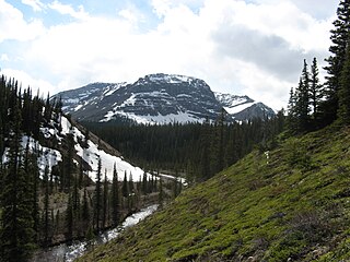
The Tonquin Valley is located in Jasper National Park, Alberta, Canada, next to the border of the provinces of Alberta and British Columbia, an area which is also the continental divide, running along the peaks of the South Jasper Range which rise above Amethyst Lake. Tonquin Creek drains Moat Lake and flows west into Mount Robson Provincial Park in British Columbia, and empties into the Fraser River. The Astoria River drains south and east into the Athabasca River.

Hamber Provincial Park is a provincial park in British Columbia, Canada, located 130 kilometres (80.7 mi) north of Golden. Straddling the Great Divide on the provincial boundary with Alberta, the park is surrounded on three sides by Jasper National Park and protects the headwaters of the Wood River at Fortress Lake.

Alberta has been a tourist destination since the early days of the 20th Century, with attractions including national parks, National Historic Sites of Canada, urban arts and cultural facilities, outdoor locales for skiing, hiking and camping, shopping locales such as West Edmonton Mall, outdoor festivals, professional athletic events, international sporting competitions such as the Commonwealth Games and Olympic Winter Games, as well as more eclectic attractions.

The Brazeau River is a river in western Alberta, Canada. It is a major tributary of the North Saskatchewan River.

Alberta's Rockies comprise the Canadian Rocky Mountains in Alberta, Canada. On the southwestern part of the province along the British Columbia border, the region covers all but the south of Census Division 15.
Cardinal River is a short river in western Alberta, Canada. It flows from the Canadian Rockies, and empties into the Brazeau River, itself a major tributary of the North Saskatchewan River.

The Fiddle River is a medium-sized tributary of the Athabasca River, flowing into the river near the east gate of Jasper National Park in Alberta, Canada. The Fiddle River forms at the base of Fiddle Pass, with meltwater from Mount Bryant, Mount Gregg, Mount Sir Harold Mitchel, and Mount Barry. The river flows in a general northeast direction before its confluence with the Athabasca. The Fiddle River parallels the road to the popular Miette Hotsprings for a portion of its course.
The Jackpine River is an early tributary of the Smoky River. It forms in the Canadian Rockies, within Willmore Wilderness Park, in the province of Alberta, north of Jasper National Park. The river collects the runoff from Resthaven Mountain, Barricade Mountain, Jackpine Mountain, Mount Holmes, Perseverance Mountain, and Draco Peak.

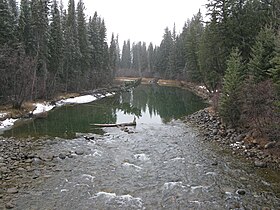
The Snaring River is a medium-sized river in the Canadian Rockies. It runs through parts of Jasper National Park in Alberta, Canada. The Snaring River is a significant tributary of the Athabasca River. The Snaring is named after a former local tribe of first nations people who lived in dugouts and trapped animals with snares.
Mount Bridgland is a 2,930-metre (9,610 ft) mountain located in the Victoria Cross Ranges of Jasper National Park in Alberta, Canada. It was named by Frank Sissons in 1923 after Morrison P. Bridgland (1878-1948), a Dominion Land Surveyor who named many peaks in Jasper Park and the Canadian Rockies.

Utopia Mountain is a 2,602-metre (8,537-foot) mountain located in the Miette Range of Jasper National Park, in the Canadian Rockies of Alberta, Canada. It was named by Morrison P. Bridgland in 1916. Bridgland (1878-1948) was a Dominion Land Surveyor who named many peaks in Jasper Park and the Canadian Rockies.

Jasper Lake is a lake located in the Rockies of Jasper National Park in Alberta, Canada. It is part of the Athabasca River, where the river broadens out. Its westernmost shore lies about 15 miles (24 km) northeast from the town of Jasper along the Yellowhead Highway and stretches farther east for about 6 miles (9.7 km).

Roche Miette is a 2,316-metre (7,598-foot) mountain located at the northwestern tip of the Miette Range in Jasper National Park, in the Canadian Rockies of Alberta, Canada. The peak is a prominent landmark in the Athabasca Valley that is situated approximately thirty kilometres north-northeast of the municipality of Jasper, and four kilometres northeast of the Jasper House National Historic Site. It is visible from Highway 16 and the Canadian. Its nearest higher peak is Capitol Mountain, 5.0 km (3.1 mi) to the southeast. Roche Miette translates from French as Crumb Rock.

Indian Ridge is a 2,820-metre (9,252 ft) mountain located in Jasper National Park, in the Trident Range of the Canadian Rockies of Alberta, Canada. The summit is unofficially called Indian Peak. The town of Jasper is situated 9 kilometres (5.6 mi) to the north-northeast, and The Whistlers lies 2.55 kilometres (1.58 mi) to the northeast. Its nearest higher peak is Manx Peak, 4.3 km (2.7 mi) to the southwest, and Terminal Mountain lies 3.25 km (2.02 mi) to the south. The Marmot Basin alpine ski area is located 4 kilometres (2.5 mi) to the southeast. The peak is composed of sedimentary rock laid down from the Precambrian to the Jurassic periods and pushed east and over the top of younger rock during the Laramide orogeny.