Mount Columbia is a mountain located in the Winston Churchill Range of the Rocky Mountains. It is the highest point in Alberta, Canada, and is second only to Mount Robson for height and topographical prominence in the Canadian Rockies. It is located on the border between Alberta and British Columbia on the northern edge of the Columbia Icefield. Its highest point, however, lies within Jasper National Park in Alberta.

Stutfield Peak is a mountain in Jasper National Park, Alberta, Canada. It is located at the northern end of the Columbia Icefield, 6 kilometres (3.7 mi) north-west from Mount Kitchener, in the Winston Churchill Range of the Canadian Rockies. The peak has two summits - Stutfield East and Stutfield West - and is therefore sometimes referred to as The Stutfields. The West peak is higher than the East peak by 50 m (164 ft).

Brussels Peak is a 3,161-metre (10,371 ft) mountain summit located in the Athabasca River valley of Jasper National Park, in the Canadian Rockies of Alberta, Canada. The nearest higher peak is Mount Fryatt, 6.75 km (4.19 mi) to the northwest. Brussels Peak can be seen from the Icefields Parkway.

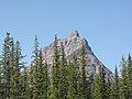
Chetamon Mountain is a 2,606-metre (8,550-foot) mountain summit located in Jasper National Park, in the De Smet Range of the Canadian Rockies in Alberta, Canada. The peak is situated 18 kilometres (11 mi) north of the municipality of Jasper, in the Athabasca Valley and is visible from Highway 16 and the Canadian. Its nearest higher peak is Cliff Mountain, 3.5 km (2.2 mi) to the northwest.
Terminal Mountain is a 2,835-metre (9,301 ft) mountain summit located in Jasper National Park, in the Trident Range of the Canadian Rockies of Alberta, Canada. The town of Jasper is situated 12 kilometers to the north-northeast. Terminal Mountain forms the west buttress of Marmot Pass, and the east buttress is formed by Marmot Mountain, home of the Marmot Basin alpine ski area. Peveril Peak rises to the south across Circus Valley, and the north side towers above the valley of Whistlers Creek. The nearest higher neighbor is Manx Peak, 2.0 km (1.2 mi) to the west.

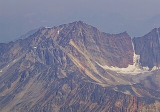
Franchère Peak is a 2,805-metre (9,203-foot) mountain summit located in the Astoria River valley of Jasper National Park, in the Canadian Rockies of Alberta, Canada. The mountain was named in 1917 for Gabriel Franchère (1786–1863), a French Canadian author and explorer of the Pacific Northwest who wrote the first account of an 1814 journey over Athabasca Pass. Franchère was a member of John Jacob Astor's Pacific Fur Company and sailed to Fort Astoria on the Tonquin, after which the nearby Tonquin Valley was named. The mountain's name was officially adopted on March 5, 1935 when approved by the Geographical Names Board of Canada. Its nearest higher peak is Aquila Mountain, 2.00 km (1.24 mi) to the north. Mount Edith Cavell is situated immediately south-southeast across the Astoria River valley.

Hawk Mountain is a 2,553-metre (8,376-foot) mountain summit located in Jasper National Park in Alberta, Canada. It is located near the northwest end of the Colin Range, which is a sub-range of the Canadian Rockies. The peak is situated 16 km (9.9 mi) northeast of the municipality of Jasper, and is a prominent landmark in the Athabasca Valley visible from Highway 16 and the Canadian. Its nearest higher peak is Mount Colin, 2.4 km (1.5 mi) to the southeast. Hawk Mountain was named in 1916 by Morrison P. Bridgland for the fact that a hawk was flying near the summit at the time it was named. Bridgland (1878-1948) was a Dominion Land Surveyor who named many peaks in Jasper Park and the Canadian Rockies. The mountain's name was officially adopted in 1956 by the Geographical Names Board of Canada.
Esplanade Mountain is a 2,301-metre (7,549-foot) mountain summit located in Jasper National Park, in the Canadian Rockies of Alberta, Canada. The peak is situated 20 kilometres north of the municipality of Jasper, in the Athabasca Valley and is visible from Highway 16 and the Canadian. Its nearest higher peak is Cliff Mountain, 5.0 km (3.1 mi) to the west. Esplanade Mountain was named in 1916 by Morrison P. Bridgland for its long, flat top resembling an esplanade. Bridgland (1878-1948) was a Dominion Land Surveyor who named many peaks in Jasper Park and the Canadian Rockies. The mountain's name was officially adopted in 1956 by the Geographical Names Board of Canada.

Manx Peak is a 3,044-metre (9,987 ft) mountain summit located in Jasper National Park, in the Trident Range of the Canadian Rockies of Alberta, Canada. The town of Jasper is situated 14 kilometres (8.7 mi) to the north-northeast. Circus Valley lies at the south side of the mountain, and the northeast aspect towers above the head of the valley of Whistlers Creek. Its nearest higher peak is Mount Estella, 1.8 km (1.1 mi) to the southwest, and Terminal Mountain lies 2.0 km (1.2 mi) to the east. The peak is composed of sedimentary rock laid down from the Precambrian to the Jurassic periods and pushed east and over the top of younger rock during the Laramide orogeny.

Indian Ridge is a 2,820-metre (9,252 ft) mountain located in Jasper National Park, in the Trident Range of the Canadian Rockies of Alberta, Canada. The summit is unofficially called Indian Peak. The town of Jasper is situated 9 kilometres (5.6 mi) to the north-northeast, The Whistlers lies 2.55 kilometres (1.58 mi) to the northeast, and Muhigan Mountain is 4.8 kilometres (3.0 mi) to the west-northwest. The nearest higher peak is Manx Peak, 4.3 km (2.7 mi) to the southwest, and Terminal Mountain lies 3.25 km (2.02 mi) to the south. The Marmot Basin alpine ski area on Marmot Mountain is located 4 kilometres (2.5 mi) to the southeast. The peak is composed of sedimentary rock laid down from the Precambrian to the Jurassic periods and pushed east and over the top of younger rock during the Laramide orogeny.

Throne Mountain is a prominent 3,120-metre (10,236 ft) mountain summit located in Jasper National Park, in the South Jasper Ranges of the Canadian Rockies of Alberta, Canada. It is situated 24 kilometres (15 mi) south of the town of Jasper, and 8 kilometres (5.0 mi) east of Tonquin Valley. The nearest higher neighbor is Mount Edith Cavell, 5.8 km (3.6 mi) to the east, and Franchère Peak lies 7.0 km (4.3 mi) to the northeast. The peak is composed of sedimentary rock laid down from the Precambrian to the Jurassic periods, that was pushed east and over the top of younger rock during the Laramide orogeny.

Muhigan Mountain is a 2,626-metre (8,615 ft) mountain located in Alberta, Canada.

Cairngorm is a 2,610-metre (8,563 ft) mountain located in Alberta, Canada.

Lectern Peak is a 2,772-metre (9,094-foot) mountain summit located in Alberta, Canada.

Marmot Mountain is a 2,608-metre (8,556-foot) mountain summit located in Alberta, Canada.
Roche Noire is a 2,920-metre (9,580 ft) mountain located in Alberta, Canada.

Oldhorn Mountain is a 3,000-metre (9,843-foot) summit in Alberta, Canada.

Blackhorn Peak is a 3,000-metre (9,800-foot) summit in Alberta, Canada.

Mount Estella is a 3,069-metre (10,069-foot) mountain summit in Alberta, Canada.
Majestic Mountain is a 3,086-metre (10,125-foot) summit in Alberta, Canada.