
Mount Columbia is a mountain located in the Winston Churchill Range of the Rocky Mountains. It is the highest point in Alberta, Canada, and is second only to Mount Robson for height and topographical prominence in the Canadian Rockies. It is located on the border between Alberta and British Columbia on the northern edge of the Columbia Icefield. Its highest point, however, lies within Jasper National Park in Alberta.

Mount Saskatchewan is a mountain located in the North Saskatchewan River valley of Banff National Park, in the Canadian Rockies of Alberta, Canada.

Mount Hector is a 3,394-metre (11,135-foot) mountain summit located in the Bow River valley of Banff National Park, in the Canadian Rockies of Alberta, Canada. The mountain was named in 1884 by George M. Dawson after James Hector, a geologist on the Palliser expedition. The mountain is located beside the Icefields Parkway, 17 km (11 mi) north of Lake Louise.

Mount Lyell is a mountain on the Alberta–British Columbia border in western Canada. Comprising five distinct summits, Mount Lyell reaches a height of 3,498 m (11,476 ft). The mountain was named by James Hector in 1858 in recognition of Scottish geologist Sir Charles Lyell.

Mount Aberdeen is a 3,152-metre (10,341-foot) mountain summit located in the Lake Louise area of Banff National Park, in the Canadian Rockies of Alberta, Canada. Its nearest higher peak is Mount Lefroy, 2.9 km (1.8 mi) to the southwest. Haddo Peak is on the same massif with Mount Aberdeen, and the Aberdeen Glacier is between the two peaks.
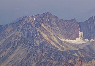
Mount Tekarra is a 2,694-metre (8,839-foot) mountain summit located in the Athabasca River valley of Jasper National Park, in the Canadian Rockies of Alberta, Canada. It is situated at the northwest end of the Maligne Range and is visible from Jasper and the Icefields Parkway. The nearest higher neighbor is The Watchtower, 7.0 km (4.3 mi) to the east.

Mount Lowell is a 3,150-metre (10,330 ft) mountain summit located in the Athabasca River valley of Jasper National Park, in the Canadian Rockies of Alberta, Canada. The name has not been officially adopted yet for this peak. It is situated at the head of Fryatt Creek Valley on the same high ridge as Mount Christie, Xerxes Peak, and Brussels Peak which is the nearest higher peak, 2.0 km (1.2 mi) to the north. Mount Lowell can be seen from the Icefields Parkway.

Franchère Peak is a 2,805-metre (9,203-foot) mountain summit located in the Astoria River valley of Jasper National Park, in the Canadian Rockies of Alberta, Canada. The mountain was named in 1917 for Gabriel Franchère (1786–1863), a French Canadian author and explorer of the Pacific Northwest who wrote the first account of an 1814 journey over Athabasca Pass. Franchère was a member of John Jacob Astor's Pacific Fur Company and sailed to Fort Astoria on the Tonquin, after which the nearby Tonquin Valley was named. The mountain's name was officially adopted on March 5, 1935 when approved by the Geographical Names Board of Canada. Its nearest higher peak is Aquila Mountain, 2.00 km (1.24 mi) to the north. Mount Edith Cavell is situated immediately south-southeast across the Astoria River valley.
Evelyn Peak is a 2,855 m (9,367 ft) mountain summit in the Athabasca River valley of Jasper National Park, in the Canadian Rockies of Alberta, Canada. THe nearest higher peak is Mount Kerkeslin, 5.0 km (3.1 mi) to the southwest, and Mount Hardisty is 6.0 km (3.7 mi) to the northwest. All three are part of the Maligne Range. Evelyn Peak is composed of sedimentary rock laid down during the Cambrian period and pushed east and over the top of younger rock during the Laramide orogeny. The mountain is at the headwaters of Evelyn Creek, and three kilometres south of Evelyn Pass. The creek and pass were named in 1921 for Evelyn Cavendish, Duchess of Devonshire (1870–1960), who visited nearby Maligne Lake in 1920. The mountain's name however, has not yet been officially adopted by the Geographical Names Board of Canada.

Mount Erebus is a 3,112-metre (10,210-foot) mountain summit located near the Tonquin Valley of Jasper National Park in Alberta, Canada. Mount Erebus is composed of sedimentary rock laid down during the Cambrian period, then was pushed east and over the top of younger rock during the Laramide orogeny. Its nearest higher peak is Mount Fraser, 4.0 km (2.5 mi) to the northwest. The Continental Divide lies 3 km (1.9 mi) to the west, Angle Peak is situated 4.5 km (2.8 mi) to the southeast, and The Ramparts are 5.0 km (3.1 mi) to the north. The mountain's north ridge terminates at Outpost Peak.

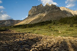
Indian Ridge is a 2,820-metre (9,252 ft) mountain located in Jasper National Park, in the Trident Range of the Canadian Rockies of Alberta, Canada. The summit is unofficially called Indian Peak. The town of Jasper is situated 9 kilometres (5.6 mi) to the north-northeast, The Whistlers lies 2.55 kilometres (1.58 mi) to the northeast, and Muhigan Mountain is 4.8 kilometres (3.0 mi) to the west-northwest. The nearest higher peak is Manx Peak, 4.3 km (2.7 mi) to the southwest, and Terminal Mountain lies 3.25 km (2.02 mi) to the south. The Marmot Basin alpine ski area on Marmot Mountain is located 4 kilometres (2.5 mi) to the southeast. The peak is composed of sedimentary rock laid down from the Precambrian to the Jurassic periods and pushed east and over the top of younger rock during the Laramide orogeny.

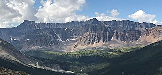
Throne Mountain is a prominent 3,120-metre (10,236 ft) mountain summit located in Jasper National Park, in the South Jasper Ranges of the Canadian Rockies of Alberta, Canada. It is situated 24 kilometres (15 mi) south of the town of Jasper, and 8 kilometres (5.0 mi) east of Tonquin Valley. The nearest higher neighbor is Mount Edith Cavell, 5.8 km (3.6 mi) to the east, and Franchère Peak lies 7.0 km (4.3 mi) to the northeast. The peak is composed of sedimentary rock laid down from the Precambrian to the Jurassic periods, that was pushed east and over the top of younger rock during the Laramide orogeny.

Lectern Peak is a 2,772-metre (9,094-foot) mountain summit located in Alberta, Canada.

Marmot Mountain is a 2,608-metre (8,556-foot) mountain summit located in Alberta, Canada.
Roche Noire is a 2,920-metre (9,580 ft) mountain located in Alberta, Canada.

Peveril Peak is a 2,686-metre (8,812-foot) mountain summit located in Alberta, Canada.
Saddle Mountain is a 2,433-metre (7,982 ft) summit in Alberta, Canada.

Blackhorn Peak is a 3,000-metre (9,800-foot) summit in Alberta, Canada.

Mount Estella is a 3,069-metre (10,069-foot) mountain summit in Alberta, Canada.
Majestic Mountain is a 3,086-metre (10,125-foot) summit in Alberta, Canada.


