
Mount Columbia is a mountain located in the Winston Churchill Range of the Rocky Mountains. It is the highest point in Alberta, Canada, and is second only to Mount Robson for height and topographical prominence in the Canadian Rockies. It is located on the border between Alberta and British Columbia on the northern edge of the Columbia Icefield. Its highest point, however, lies within Jasper National Park in Alberta.

Mount Wilcox is a 2,884-metre (9,462-foot) mountain summit located in the Canadian Rockies of Alberta, Canada. It is located in Jasper National Park right beside the Columbia Icefield visitor centre with the Icefields Parkway traversing the western base of the mountain. Its nearest higher peak is Nigel Peak, 3.35 km (2.08 mi) to the northeast. Mount Wilcox is a moderate scramble from Wilcox Pass. Due to its location, it provides one of the best views of the Athabasca Glacier.
Amber Mountain is a 2,565-metre (8,415-foot) mountain summit located in the Maligne Range of Jasper National Park, in the Canadian Rockies of Alberta, Canada. Amber Mountain was so named on account of amber-hued shale outcroppings. The mountain was named in 1916 by Morrison P. Bridgland (1878-1948), a Dominion Land Surveyor who named many peaks in Jasper Park and the Canadian Rockies. The mountain's name was officially adopted in 1947 when approved by the Geographical Names Board of Canada. Its nearest higher peak is The Watchtower, 5.0 km (3.1 mi) to the east. Amber Mountain is composed of sedimentary rock laid down during the Cambrian period and pushed east and over the top of younger rock during the Laramide orogeny.

Angle Peak is a 2,910-metre (9,547 ft) mountain summit located in Jasper National Park, in the Canadian Rockies of Alberta, Canada. Angle Peak was named for the fact it stands where the ridge makes a bend. The descriptive name was applied in 1916 by Morrison P. Bridgland (1878-1948), a Dominion Land Surveyor who named many peaks in Jasper Park and the Canadian Rockies. The mountain's name was made official in 1935 by the Geographical Names Board of Canada. The mountain is situated in the Tonquin Valley, with Angle Glacier on its north slope, Alcove Mountain to its immediate west, The Ramparts 10 km (6.2 mi) to the northwest, and Mount Edith Cavell 12 km (7.5 mi) to the northeast.
Curator Mountain is a 2,624-metre (8,609-foot) mountain summit located in the Maligne Range of Jasper National Park, in the Canadian Rockies of Alberta, Canada. Curator Mountain was so named on account of its central location, as if it were the "custodian" of Shovel Pass. The mountain was named in 1916 by Morrison P. Bridgland (1878-1948), a Dominion Land Surveyor who named many peaks in Jasper Park and the Canadian Rockies. The mountain's name was officially adopted in 1947 when approved by the Geographical Names Board of Canada. Its nearest higher peak is Trowel Peak, 7.7 km (4.8 mi) to the southeast. Curator Mountain is composed of sedimentary rock laid down during the Cambrian period and pushed east and over the top of younger rock during the Laramide orogeny.
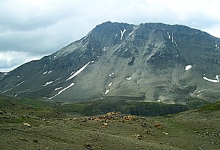
Nigel Peak is a 3,211-metre (10,535-foot) mountain summit located on the shared border of Banff National Park and Jasper National Park, in the Canadian Rockies of Alberta, Canada. Nigel has two peaks, the north summit is the highest point. The nearest higher peak is Mount Athabasca, 6.4 km (4.0 mi) to the south-southwest. Nigel Peak is situated immediately north of Sunwapta Pass and can be seen from the Icefields Parkway and from Athabasca Glacier. Topographic relief is significant as the summit rises 1,100 metres (3,609 ft) above the parkway in two kilometres (1.2 mile).

Mount Hardisty is a 2,716 m (8,911 ft) mountain summit located in the Athabasca River valley of Jasper National Park, in the Canadian Rockies of Alberta, Canada. Its nearest higher peak is Mount Kerkeslin, 6.0 km (3.7 mi) to the south. Both mountains are part of the Maligne Range and are visible from the Icefields Parkway.

The Mitre is a 2,850-metre (9,350-foot) mountain summit located in the Lake Louise area of Banff National Park, in the Canadian Rockies of Alberta, Canada. Its nearest higher peak is Mount Lefroy, 1.0 km (0.62 mi) to the west. Mount Aberdeen is 2.0 km (1.2 mi) to the north-northeast, Lefroy Glacier immediately north, Mitre Glacier southwest, and Paradise Valley to the southeast.

Kleodora Peak is a 2,850-metre (9,350 ft) mountain summit located in the Athabasca River valley of Jasper National Park, in the Canadian Rockies of Alberta, Canada. It is situated at the head of Fryatt Creek Valley on the same high ridge as Mount Christie, Brussels Peak, Mount Lowell, Xerxes Peak, and Karpathos Peak. Its nearest higher peak is Parnassus Peak, 1.0 km (0.62 mi) to the north. The mountain was named for Kleodora, who in Greek mythology lived on Mount Parnassus. The name has not been officially adopted yet for this peak. An unnamed glacier lies below the eastern slope in the cirque between Kleodora Peak and Mount Belanger.

Mount Jellicoe is a 3,075-metre (10,089-foot) mountain summit located in Peter Lougheed Provincial Park in the Canadian Rockies of Alberta, Canada. Its nearest higher peak is Mount Smith-Dorrien, 2.0 km (1.2 mi) to the north. The Haig Glacier lies below the west aspect of Jellicoe, and the Smith-Dorrien Glacier lies to the north. The Continental Divide is 2.0 km (1.2 mi) to the west.

Manx Peak is a 3,044-metre (9,987 ft) mountain summit located in Jasper National Park, in the Trident Range of the Canadian Rockies of Alberta, Canada. The town of Jasper is situated 14 kilometres (8.7 mi) to the north-northeast. Circus Valley lies at the south side of the mountain, and the northeast aspect towers above the head of the valley of Whistlers Creek. Its nearest higher peak is Mount Estella, 1.8 km (1.1 mi) to the southwest, and Terminal Mountain lies 2.0 km (1.2 mi) to the east. The peak is composed of sedimentary rock laid down from the Precambrian to the Jurassic periods and pushed east and over the top of younger rock during the Laramide orogeny.

The Watchtower is a 2,791-metre (9,157 ft) mountain summit located in the Maligne River valley of Jasper National Park, in the Canadian Rockies of Alberta, Canada. It is situated in the Maligne Range and is visible from the Maligne Lake Road where it towers over Medicine Lake. Its nearest higher peak is Sirdar Mountain, 11.64 km (7.23 mi) to the north.
Evelyn Peak is a 2,855 m (9,367 ft) mountain summit in the Athabasca River valley of Jasper National Park, in the Canadian Rockies of Alberta, Canada. THe nearest higher peak is Mount Kerkeslin, 5.0 km (3.1 mi) to the southwest, and Mount Hardisty is 6.0 km (3.7 mi) to the northwest. All three are part of the Maligne Range. Evelyn Peak is composed of sedimentary rock laid down during the Cambrian period and pushed east and over the top of younger rock during the Laramide orogeny. The mountain is at the headwaters of Evelyn Creek, and three kilometres south of Evelyn Pass. The creek and pass were named in 1921 for Evelyn Cavendish, Duchess of Devonshire (1870–1960), who visited nearby Maligne Lake in 1920. The mountain's name however, has not yet been officially adopted by the Geographical Names Board of Canada.

Mount Erebus is a 3,112-metre (10,210-foot) mountain summit located near the Tonquin Valley of Jasper National Park in Alberta, Canada. Mount Erebus is composed of sedimentary rock laid down during the Cambrian period, then was pushed east and over the top of younger rock during the Laramide orogeny. Its nearest higher peak is Mount Fraser, 4.0 km (2.5 mi) to the northwest. The Continental Divide lies 3 km (1.9 mi) to the west, Angle Peak is situated 4.5 km (2.8 mi) to the southeast, and The Ramparts are 5.0 km (3.1 mi) to the north. The mountain's north ridge terminates at Outpost Peak.

Mount Geikie, pronounced like "geeky", is a 3,298-metre (10,820-foot) mountain summit located in Mount Robson Provincial Park in British Columbia, Canada. Situated 28 km (17 mi) southwest of Jasper near the Tonquin Valley, Mount Geikie is the highest peak of The Ramparts in the Canadian Rockies, one of the most beautiful mountain meccas in the world. Its nearest higher peak is Mount Fraser, 8.0 km (5.0 mi) to the southeast, and the Continental Divide lies 3.0 km (1.9 mi) to the east. Mount Geikie is composed of quartzite of the Cambrian period. This rock was pushed east and over the top of younger rock during the Laramide orogeny. The vertical wall of its north face is over 1,500-metre (4,900-foot) high, and has been compared to the other great north faces of the Canadian Rockies such as North Twin, Alberta, and Kitchener.

Indian Ridge is a 2,820-metre (9,252 ft) mountain located in Jasper National Park, in the Trident Range of the Canadian Rockies of Alberta, Canada. The summit is unofficially called Indian Peak. The town of Jasper is situated 9 kilometres (5.6 mi) to the north-northeast, The Whistlers lies 2.55 kilometres (1.58 mi) to the northeast, and Muhigan Mountain is 4.8 kilometres (3.0 mi) to the west-northwest. The nearest higher peak is Manx Peak, 4.3 km (2.7 mi) to the southwest, and Terminal Mountain lies 3.25 km (2.02 mi) to the south. The Marmot Basin alpine ski area on Marmot Mountain is located 4 kilometres (2.5 mi) to the southeast. The peak is composed of sedimentary rock laid down from the Precambrian to the Jurassic periods and pushed east and over the top of younger rock during the Laramide orogeny.

Throne Mountain is a prominent 3,120-metre (10,236 ft) mountain summit located in Jasper National Park, in the South Jasper Ranges of the Canadian Rockies of Alberta, Canada. It is situated 24 kilometres (15 mi) south of the town of Jasper, and 8 kilometres (5.0 mi) east of Tonquin Valley. The nearest higher neighbor is Mount Edith Cavell, 5.8 km (3.6 mi) to the east, and Franchère Peak lies 7.0 km (4.3 mi) to the northeast. The peak is composed of sedimentary rock laid down from the Precambrian to the Jurassic periods, that was pushed east and over the top of younger rock during the Laramide orogeny.

Lectern Peak is a 2,772-metre (9,094-foot) mountain summit located in Alberta, Canada.

Marmot Mountain is a 2,608-metre (8,556-foot) mountain summit located in Alberta, Canada.

Blackhorn Peak is a 3,000-metre (9,800-foot) summit in Alberta, Canada.


