
The Athabasca River originates from the Columbia Glacier of the Columbia Icefield in Jasper National Park in Alberta, Canada. The impressive and scenic Athabasca Falls is located upstream about 30 km (19 mi) from the Jasper townsite.

Lake Athabasca is located in the northwest corner of Saskatchewan and the northeast corner of Alberta between 58° and 60° N. The lake is 26% in Alberta and 74% in Saskatchewan.
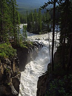
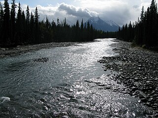
The Sunwapta River is a major tributary of the Athabasca River in Jasper National Park in Alberta, Canada.

The Peace River is a 1,923-kilometre-long (1,195 mi) river in Canada that originates in the Rocky Mountains of northern British Columbia and flows to the northeast through northern Alberta. The Peace River joins the Athabasca River in the Peace-Athabasca Delta to form the Slave River, a tributary of the Mackenzie River. The Finlay River, the main headwater of the Peace River, is regarded as the ultimate source of the Mackenzie River. The combined Finlay–Peace–Slave–Mackenzie river system is the 13th longest river system in the world.
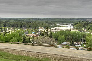
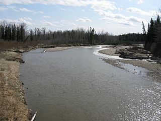
Fort Assiniboine is a hamlet in northwest Alberta, Canada, within Woodlands County. It is located along the north shore of the Athabasca River at the junction of Highway 33 and Highway 661. It is approximately 39 kilometres (24 mi) northwest of Barrhead, 62 kilometres (39 mi) southeast of Swan Hills and 91 kilometres (57 mi) northeast of Whitecourt.

Athabasca Pass is a high mountain pass in the Canadian Rockies on the border between Alberta and British Columbia. In fur trade days it connected Jasper House on the Athabasca River with Boat Encampment on the Columbia River.

The Tonquin Valley is located in Jasper National Park, Alberta, Canada, next to the border of the provinces of Alberta and British Columbia, an area which is also the continental divide, running along the peaks of the South Jasper Range which rise above Amethyst Lake. Tonquin Creek drains Moat Lake and flows west into Mount Robson Provincial Park in British Columbia, and empties into the Fraser River. The Astoria River drains south and east into the Athabasca River.

The Chaba River is a short river in western Alberta, Canada. It flows from the Canadian Rockies, and joins the Athabasca River.

The Fiddle River is a medium-sized tributary of the Athabasca River, flowing into the river near the east gate of Jasper National Park in Alberta, Canada. The Fiddle River forms at the base of Fiddle Pass, with meltwater from Mount Bryant, Mount Gregg, Mount Sir Harold Mitchel, and Mount Barry. The river flows in a general northeast direction before its confluence with the Athabasca. The Fiddle River parallels the road to the popular Miette Hotsprings for a portion of its course.
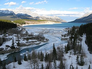
The Cline River is a short river in western Alberta, Canada. It flows from Pinto Lake and joins the North Saskatchewan River at Lake Abraham in west-central Alberta.

The Miette River is a short river in Jasper National Park, Alberta, Canada. It flows south-southwest through the Rocky Mountains before draining into the Athabasca River.

The Embarras River is a short river in west-central Alberta, Canada. The river likely derived its name from the French word for obstruction, because it is often obstructed by driftwood.
The Maligne River is a medium-sized river in the Canadian Rockies. It runs through parts of Jasper National Park in Alberta, Canada. The Maligne is a major tributary of the Athabasca River. The river takes from the French word for malignant or wicked. It is theorised that a Belgian priest voyageur created this name in reference to the current of the river near its confluence with the Athabasca River.
The Snake Indian River is a large tributary of the Athabasca River, exiting entirely within Jasper National Park. The Snake Indian forms at Snake Indian Pass, south of Monte Christo Mountain and Snake Indian Mountain, north of Calumet Peak. The river travels in a general northwest direction before turning sharply south. The river plummets over the massive Snake Indian Falls before joining the Athabasca River downstream of Jasper Lake, near the east gate of Jasper National Park.
The Freeman River is a short river in west-central Alberta. The Freeman takes its name from the fur traders, who, after leaving the employ of the Hudson's Bay Company or the North West Company, decided to remain in the interior and work as free trappers or free hunters.

The Snaring River is a medium-sized river in the Canadian Rockies. It runs through parts of Jasper National Park in Alberta, Canada. The Snaring River is a significant tributary of the Athabasca River. The Snaring is named after a former local tribe of first nations people who lived in dugouts and trapped animals with snares.
The Whirlpool River is a short river in Jasper National Park, Alberta, Canada. It is an early tributary of the Athabasca River.

The Gregg River is a short river in west-central Alberta. The river is named after John James Gregg (1840–1941), a prospector and trapper prominent in the area.
The Committee's Punch Bowl is a small tarn on the continental divide straddling the border between the Canadian provinces of Alberta and British Columbia. George Simpson, governor of the Hudson's Bay Company, named the lake for London-based managing committee of the company in 1824. While journeying through the company's trade area in what is now western Canada and parts of Alaska and the northwestern United States, he saw the lake at the summit of Athabasca Pass on an important trade route for the company's traders.

Franchère Peak is a 2,805-metre (9,203-foot) mountain summit located in the Astoria River valley of Jasper National Park, in the Canadian Rockies of Alberta, Canada. The mountain was named in 1917 for Gabriel Franchère (1786–1863), a French Canadian author and explorer of the Pacific Northwest who wrote the first account of an 1814 journey over Athabasca Pass. Franchère was a member of John Jacob Astor's Pacific Fur Company and sailed to Fort Astoria on the Tonquin, after which the nearby Tonquin Valley was named. The mountain's name was officially adopted on March 5, 1935 when approved by the Geographical Names Board of Canada. Its nearest higher peak is Aquila Mountain, 2.00 km (1.24 mi) to the north. Mount Edith Cavell is situated immediately south-southeast across the Astoria River valley.


