
Taiga, generally referred to in North America as a boreal forest or snow forest, is a biome characterized by coniferous forests consisting mostly of pines, spruces, and larches.

Alberta is one of the thirteen provinces and territories of Canada. Located in Western Canada, the province has an area of 661,190 km2 (255,290 sq mi) and is bounded to the south by the United States state of Montana along 49° north for 298 km (185 mi); to the east at 110° west by the province of Saskatchewan for 1,223 km (760 mi); and at 60° north the Northwest Territories for 644 km (400 mi). The southern half of the province borders British Columbia along the Continental Divide of the Americas on the peaks of the Rocky Mountains, while the northern half borders British Columbia along the 120th meridian west. Along with Saskatchewan it is one of only two landlocked provinces or territories.

Yukon is in the northwestern corner of Canada and is bordered by Alaska and the Northwest Territories. The sparsely populated territory abounds with natural scenic beauty, with snowmelt lakes and perennial white-capped mountains, including many of Canada's highest mountains. The territory's climate is Arctic in territory north of Old Crow, subarctic in the region, between Whitehorse and Old Crow, and humid continental climate south of Whitehorse and in areas close to the British Columbia border. Most of the territory is boreal forest with tundra being the main vegetation zone only in the extreme north and at high elevations.

British Columbia is the westernmost province of Canada, bordered by the Pacific Ocean. With an area of 944,735 km2 (364,764 sq mi) it is Canada's third-largest province. The province is almost four times the size of the United Kingdom and larger than every United States state except Alaska. It is bounded on the northwest by the U.S. state of Alaska, directly north by Yukon and the Northwest Territories, on the east by Alberta, and on the south by the U.S. states of Washington, Idaho, and Montana. Formerly part of the British Empire, the southern border of British Columbia was established by the 1846 Oregon Treaty. The province is dominated by mountain ranges, among them the Canadian Rockies but dominantly the Coast Mountains, Cassiar Mountains, and the Columbia Mountains. Most of the population is concentrated on the Pacific coast, notably in the area of Vancouver, located on the southwestern tip of the mainland, which is known as the Lower Mainland. It is the most mountainous province of Canada.
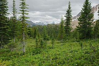
The Montane Cordillera Ecozone, as defined by the Commission for Environmental Cooperation (CEC), is an ecozone in south-central British Columbia and southwestern Alberta, Canada. A rugged and mountainous ecozone spanning 473,000 square kilometres, it still contains "two of the few significant agricultural areas of the province", the Creston Valley and the Okanagan Valley. Primarily a mountainous region, it consists of rugged ecosystems such as alpine tundra, dry sagebrush and dense conifer forests. The interior plains are encircled by a ring of mountains. The area has a mild climate throughout the year, with typically dry summers and wet winters.

The Arctic Archipelago Marine Ecozone, as defined by the Commission for Environmental Cooperation (CEC), is a marine ecozone in the Canadian Arctic, encompassing Hudson Bay, James Bay, the internal waters and some shores of the islands in the Canadian Arctic Archipelago, and the shores of the territories, northern Ontario and western Quebec. Early exploration of these waters by Europeans were conducted to find a passage to the Orient, now referred to as the Northwest Passage.

The Taiga Shield Ecozone, as defined by the Commission for Environmental Cooperation (CEC), is an ecozone which stretches across Canada's subarctic region. Some regions exhibit exposed Precambrian bedrock of the Canadian Shield, the oldest of the world's geological formations. The world's oldest rocks, dating to four billion years, are found in the Canadian Shield north of Great Slave Lake.
The Atlantic Maritime Ecozone, as defined by the Commission for Environmental Cooperation (CEC), is an ecozone which covers the Canadian provinces of Prince Edward Island, Nova Scotia, and New Brunswick, as well as the Gaspé Peninsula of Quebec. It is adjacent to the Atlantic Marine Ecozone to the east, and the Mixedwood Plains to the west. The roughly-corresponding Level I Ecoregion to this ecozone in the United States Environmental Protection Agency's classification, which is also part of the CEC system, is the Northern Forests ecoregion, though that classification includes the woodlands and swamps of northern Michigan and Minnesota, which are adjacent to the Boreal Shield ecozone.

The Boreal Plains Ecozone, as defined by the Commission for Environmental Cooperation (CEC), is a terrestrial ecozone in the western Canadian provinces of Manitoba, Saskatchewan and Alberta. It also has minor extensions into northeastern British Columbia and south-central Northwest Territories. The region extends over 779,471 km2, of which 58,981 km2 is conserved.
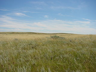
The Prairies Ecozone is a Canadian terrestrial ecozone which spans the southern areas of the Prairie provinces of Alberta, Saskatchewan, and Manitoba. It is a productive agricultural area, and is commonly referred to as "Canada's breadbasket". Farmland covers about 94% of the land, and is the dominant domestic economic activity of the zone, as well as an important factor in Canadian foreign trade. Natural gas and oil are abundant in the area. The corresponding Level II ecoregion of the US Environmental Protection Agency is the Great Plains Ecoregion.
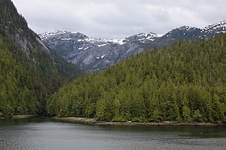
The Pacific Maritime Ecozone, as defined by the Commission for Environmental Cooperation (CEC), is a Canadian terrestrial ecozone, spanning a strip approximately 200 kilometres wide along the British Columbia Coast, then narrowing along the border with Alaska. It also includes all marine islands of British Columbia and a small portion of the southwestern corner of the Yukon. Fourteen ecoregions comprise the Ecozone, ranging from the Mount Logan Ecoregion in the north to the Cascade Ecoregion and Lower Mainland Ecoregion in the south.
The Taiga Plain Ecozone, as defined by the Commission for Environmental Cooperation (CEC), is a Canadian terrestrial ecozone that covers most of the western Northwest Territories, extending to northwest Alberta, northeast British Columbia and slightly overlapping northeastern Yukon.

The Taiga Cordillera Ecozone, as defined by the Commission for Environmental Cooperation (CEC), is a rugged, mountainous terrestrial ecozone of Canada spanning most of northern Yukon and significant portions of the border between the Yukon and the Northwest Territories.

The Northern Arctic Ecozone, as defined by the Commission for Environmental Cooperation (CEC), is a Canadian terrestrial ecozone which includes most of the Canadian Arctic Archipelago, the Boothia and Melville Peninsulas of Nunavut, and the northwestern tip of Quebec. Its marine borders are with the Arctic Archipelago Marine Ecozone, and it is adjacent to the mainland Southern Arctic Ecozone.

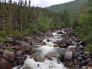
Canada's boreal forest is a vast region comprising about one third of the circumpolar boreal forest that rings the Northern Hemisphere, mostly north of the 50th parallel. Other countries with boreal forest include Russia, which contains the majority; the United States in its northernmost state of Alaska; and the Scandinavian or Northern European countries. In Europe, the entire boreal forest is referred to as taiga, not just the northern fringe where it thins out near the tree line. The boreal region in Canada covers almost 60% of the country's land area. The Canadian boreal region spans the landscape from the most easterly part of the province of Newfoundland and Labrador to the border between the far northern Yukon and Alaska. The area is dominated by coniferous forests, particularly spruce, interspersed with vast wetlands, mostly bogs and fens. The boreal region of Canada includes eight ecozones. While the biodiversity of regions varies, each ecozone has a characteristic native flora and fauna.
The Peel watershed drains 14% of the Yukon Territory Canada and flows into the Beaufort Sea via the Peel and then Mackenzie Rivers. While the lower part of the Peel River and its confluence with the Mackenzie River are in the North West Territories, most of the watershed, 68,000 km2 out of 77,000 km2 is in the Yukon. Six major tributaries and numerous smaller streams feed the Peel. The Yukon portion of the watershed is undergoing land use planning, a process laid out in Chapter 11 of the Yukon Land Claims Agreement and is called the Peel Watershed Planning Region (PWPR). This article is confined to the PWPR.
The effects of climate change in Saskatchewan are now being observed in parts of the province. There is evidence of reduction of biomass in Saskatchewan's boreal forests that is linked by researchers to drought-related water stress stemming from global warming, most likely caused by greenhouse gas emissions. While studies, as early as 1988 have shown that climate change will affect agriculture, whether the effects can be mitigated through adaptations of cultivars, or crops, is less clear. Resiliency of ecosystems may decline with large changes in temperature. The provincial government has responded to the threat of climate change by introducing a plan to reduce carbon emissions, "The Saskatchewan Energy and Climate Change Plan", in June 2007.

The Southern Hudson Bay taiga is a terrestrial ecoregion, as classified by the World Wildlife Fund, which extends along the southern coast of Hudson Bay and resides within the larger taiga biome. The region is nearly coterminous with the Hudson Plain, a Level I ecoregion of North America as designated by the Commission for Environmental Cooperation (CEC) in its North American Environmental Atlas.

Northern Cordillera forests is a taiga ecoregion that extends across the northern interior of British Columbia, southern Yukon, and a small area of the Northwest Territories as defined by the World Wildlife Fund (WWF) categorization system.
