Kicking Horse River

Last updated
Kicking Horse River
KickingHorseRiver.JPG
Kicking Horse River
Canada British Columbia relief location map.jpg
Red pog.svg
Location in British Columbia
Location
CountryCanada
ProvinceBritish Columbia
District Kootenay Land District
Physical characteristics
Source Wapta Lake
  location Yoho National Park
Mouth Columbia River
  location
Golden
  coordinates
51°18′N116°59′W / 51.300°N 116.983°W / 51.300; -116.983
Discharge 
  locationnear Golden [1]
  average40.9 m3/s (1,440 cu ft/s) [1]
  minimum2.25 m3/s (79 cu ft/s)
  maximum402 m3/s (14,200 cu ft/s)

The Kicking Horse River is in the Canadian Rockies of southeastern British Columbia, Canada. [2] The river was named in 1858, when James Hector, a member of the Palliser Expedition, reported being kicked by his packhorse while exploring the river. Hector named the river and the associated pass as a result of the incident. The Kicking Horse Pass, which connects through the Rockies to the valley of the Bow River, was the route through the mountains subsequently taken by the Canadian Pacific Railway when it was constructed during the 1880s. The railway's Big Hill and associated Spiral Tunnels are in the Kicking Horse valley and were necessitated by the steep rate of descent of the river and its valley.
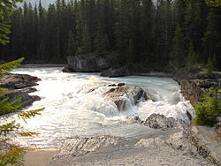
Contents

Kicking Horse Pedestrian Bridge Kicking Horse Pedestrian Bridge.jpg
Kicking Horse Pedestrian Bridge
Kicking Horse River at Park Bridge rest area near Golden. Trans Canada Highway on left, CPR mainline on right Kicking Horse River.jpg
Kicking Horse River at Park Bridge rest area near Golden. Trans Canada Highway on left, CPR mainline on right
Kicking Horse River at the feet of Chancellor Peak Yoho National Park of Canada.jpg
Kicking Horse River at the feet of Chancellor Peak

Kicking Horse Pedestrian Bridge in Golden is the longest authentic covered timber-frame bridge in Canada. [3] Planned as a community project by the Timber Framers Guild, local volunteers were joined by carpenters and timber framers from Canada, the United States and Europe. The bridge structure is 150 feet (46 m) long, with a 210,000-pound (95,000 kg) Burr arch structure. The bridge was completed in September 2001.

The Trans-Canada Highway traverses the river at several points from Yoho National Park to Golden, British Columbia. The river is spanned by the new Park Bridge. Kicking Horse Mountain Resort, named for the river and pass, is located in the Dogtooth Range of the Purcell Mountains, on the west side of the town of Golden.

Course

Wapta Falls on Kicking Horse River Wapta-Falls-2019-rainbow-Luka-Peternel.jpg
Wapta Falls on Kicking Horse River

The Kicking Horse River begins at the outlet of small Wapta Lake and flows southwest. It receives the Yoho River upstream from Field. The river continues to flow southwest until after it drops over Wapta Falls, when it takes a near hairpin turn and flows northwest into the Columbia River in Golden.

Waterfalls

The river has three waterfalls along its stretch. The first is the Kicking Horse Cascade, a long talus cascade which occurs just below the first highway crossing of the river below Wapta Lake. The second is the Natural Bridge Falls near Field. The final and largest is 100-foot (30 m) Wapta Falls, one of the largest waterfalls in Canada in both volume and width. They are over 500 feet (150 m) wide.

Natural history

History

Natural bridge across the Kicking Horse River PSM V78 D430 Natural bridge across the kicking horse river in bc.png
Natural bridge across the Kicking Horse River

The River’s unusual name stems from an incident near Wapta Falls in August 1858, Sir James Hector writes:

"A little way above this fall one of our pack horses, to escape the fallen timber, plunged into the river, luckily where it formed an eddy, but the banks were so steep that we had great difficulty in getting him out. In attempting to recatch my own horse, which had strayed off while we were engaged with the one in the water, he kicked me in the chest, but I had luckily got close to him before he struck out, so that I did not get the full force of the blow. However, it knocked me down and rendered me senseless for some time. This was unfortunate, as we had seen no tracks of game in the neighbourhood, and were now without food; but I was so hurt that we could not proceed further that day at least." - James Hector chronicles, 1858

James Hector

As surgeon and geologist to the Palliser Expedition from 1857 to 1860, Hector explored the country from the Red River Colony (Winnipeg) to Vancouver Island. He made many important observations regarding the geology and ethnology of the Canadian West and the Rocky Mountains, discovering the Kicking Horse Pass and giving the Kicking Horse River its name.

2019 Derailment

On 4 February 2019, a Canadian Pacific Railway freight train with 112 cars and 3 locomotives derailed near the Big Hill of Kicking Horse Pass. The train landed in the river, and three crew members were killed. [4]

Recreation

Several whitewater rafting companies, as well as kayakers and canoeists, use the river. The first company to raft the Kicking Horse river is named Kootenay River Runners. They continue to raft trips on the Kicking Horse daily, as well as two other nearby rivers. There are three main sections of the Kicking Horse River used for such recreation. The upper canyon (accessed via Beaverfoot Road off Highway 1 West) is a class 3-4 whitewater run suitable for canoes, kayaks and rafts. Prior to a landslide in the upper canyon, boats had to portage a one kilometre stretch of rapids in order to avoid getting caught on rocks. After the landslide, the river was narrowed, allowing boats to pass freely through the rapids. Nowadays, this stretch is named Portage/Shotgun, hence the previous need to portage the area. The middle canyon (accessed via Kicking Horse rest area) is a class 4-5, depending on water levels. This run is suitable only for experienced kayakers and rafters. Commercial rafting companies avoid this section, due to the risk involved. The lower canyon is another class 3-4 whitewater run that is run by commercial rafting companies at suitable water levels. Prior to the start of the 2016 rafting season, Canadian Pacific railway installed a gate, prohibiting road access to the lower-canyon. Because of this, many rafting companies have been forced to stop rafting this portion of the river, resulting in revenue and job loss. The Kicking Horse is home to many varieties of freshwater fish, making fishing a viable activity.

Major tributaries

See also

Notes

  1. 1 2 "Archived Hydrometric Data Search". Water Survey of Canada. Archived from the original on February 21, 2009. Retrieved October 19, 2008. Search for Station 08NA006 Kicking Horse River near Golden
  2. "Kicking Horse River". BC Geographical Names .
  3. "Kicking Horse Pedestrian Bridge". Tourism Golden. Archived from the original on 2008-11-21. Retrieved 2008-08-21.
  4. Feb 06, CBC News · Posted; February 6, 2019 10:35 AM MT | Last Updated. "Fatal train derailment: A closer look at what happened that tragic day | CBC News". CBC. Retrieved 2019-02-20.

Related Research Articles

<span class="mw-page-title-main">Yoho National Park</span> National park in British Columbia, Canada

Yoho National Park is a national park of Canada. It is located within the Rocky Mountains along the western slope of the Continental Divide of the Americas in southeastern British Columbia, bordered by Kootenay National Park to the south and Banff National Park to the east in Alberta. The word Yoho is a Cree expression of amazement or awe, and it is an apt description for the park's spectacular landscape of massive ice fields and mountain peaks, which rank among the highest in the Canadian Rockies.

<span class="mw-page-title-main">Kootenay National Park</span> National park in British Columbia, Canada

Kootenay National Park is a national park of Canada in southeastern British Columbia. The park consists of 1,406 km2 (543 sq mi) of the Canadian Rockies, including parts of the Kootenay and Park mountain ranges, the Kootenay River and the entirety of the Vermilion River. While the Vermilion River is completely contained within the park, the Kootenay River has its headwaters just outside the park boundary, flowing through the park into the Rocky Mountain Trench and eventually joining the Columbia River. The park ranges in elevation from 918 m (3,012 ft) at the southwestern park entrance to 3,424 m (11,234 ft) at Deltaform Mountain.

<span class="mw-page-title-main">Kootenay River</span> River in Western Canada and the United States

The Kootenay River or Kootenai River is a major river of the Northwest Plateau in southeastern British Columbia, Canada, and northern Montana and Idaho in the United States. It is one of the uppermost major tributaries of the Columbia River, the largest North American river that empties into the Pacific Ocean. The Kootenay River runs 781 kilometres (485 mi) from its headwaters in the Kootenay Ranges of the Canadian Rockies, flowing from British Columbia's East Kootenay region into northwestern Montana, then west into the northernmost Idaho Panhandle and returning to British Columbia in the West Kootenay region, where it joins the Columbia at Castlegar.

<span class="mw-page-title-main">Kicking Horse Pass</span> Mountain pass in Canada, between Alberta and British Columbia

Kicking Horse Pass is a high mountain pass across the Continental Divide of the Americas of the Canadian Rockies on the Alberta–British Columbia border, and lying within Yoho and Banff national parks. Divide Creek forks onto both sides of the Continental Divide.

Whitewater recreation in British Columbia is available in most of the province. Except for north-central and northeast British Columbia, the province is mostly mountainous with many glacial fed rivers draining though steep terrain creating excellent whitewater. Most commercial whitewater operations in British Columbia are rafting outfitters. However the provinces rivers are also well known to be good for whitewater kayaking, whitewater canoeing and river surfing although these activities are often done unguided.

<span class="mw-page-title-main">Cheakamus River</span> River in British Columbia, Canada

The Cheakamus River is a tributary of the Squamish River, beginning on the west slopes of Outlier Peak in Garibaldi Provincial Park upstream from Cheakamus Lake on the southeastern outskirts of the resort area of Whistler. The river flows into Cheakamus Lake before exiting it and flowing northwest until it turns south and enters Daisy Lake. Between the outlet of Daisy Lake and its mouth, much of its length is spent going through Cheakamus Canyon, where the river flows through swift rapids and even one good sized waterfall. The river flows south from the lake and through the canyon before joining the Squamish River at Cheekye, a few miles north of the town of Squamish. The river's name is an anglicization of the name of Chiyakmesh, a village of the Squamish people and a reserve of the Squamish Nation.

<span class="mw-page-title-main">Clearwater River (British Columbia)</span> River in British Columbia, Canada

The Clearwater River is the largest tributary of the North Thompson River, joining it at the community of Clearwater, British Columbia. The Clearwater rises from glaciers in the Cariboo Mountains and flows in a mostly southerly direction for 201 km (125 mi) to the North Thompson. Its entire course, except the last 5 km (3 mi), is within Wells Gray Provincial Park. Its confluence with the North Thompson is protected by North Thompson River Provincial Park.

<span class="mw-page-title-main">Waputik Icefield</span> Glacier in Canada

The Waputik Icefield is located on the Continental divide in the Canadian Rocky Mountains, in the provinces of British Columbia and Alberta. It is developed on the heights of the Waputik Range in the Central Main Ranges.

<span class="mw-page-title-main">Wapta Icefield</span> Glacier in Alberta and British Columbia, Canada

The Wapta Icefield is a series of glaciers located on the Continental Divide in the Waputik Mountains of the Canadian Rockies, in the provinces of British Columbia and Alberta, in Yoho National Park in the Canadian Rockies. The icefield is shared by Banff and Yoho National Parks and numerous outlet glaciers extend from the icefield, including the Vulture, Bow and Peyto Glaciers. Runoff from the icefields and outlet glaciers supply water to both the Kicking Horse and Bow Rivers, as well as numerous streams and lakes.

<span class="mw-page-title-main">Wapta Lake</span>

Wapta Lake is a glacial lake in Yoho National Park in the Canadian Rockies of eastern British Columbia, Canada.

<span class="mw-page-title-main">Lochsa River</span> River in Idaho, United States of America

The Lochsa River is in the northwestern United States, in the mountains of north central Idaho. It is one of two primary tributaries of the Middle Fork of the Clearwater River in the Clearwater National Forest. Lochsa is a Nez Perce word meaning rough water. The Salish name is Ep Smɫí, "It Has Salmon."

<span class="mw-page-title-main">Wapta Falls</span> Waterfalls on Kicking Horse River in Yoho National Park, British Columbia, Canada

Wapta Falls is a waterfall of the Kicking Horse River located in Yoho National Park in British Columbia, Canada. It is the largest waterfall of the Kicking Horse River, at about 18 metres (59 ft) high and 107 metres (351 ft) wide. Its average flow can reach 96 cubic metres per second (3,400 cu ft/s). The name stems from a Nakoda word meaning "river".

<span class="mw-page-title-main">Grand Canyon of the Stikine</span> Steep-sided canyon carved by the Stikine River in British Columbia, Canada

The Grand Canyon of the Stikine is a 72 km (45 mi) stretch of the Stikine River in northern British Columbia, Canada. It has been compared to the Grand Canyon of the Colorado. The canyon is home to a large population of mountain goats and other wildlife. Officially the canyon is described as unnavigable by any watercraft, however there have been numerous successful descents made by expert whitewater paddlers since the first attempt in 1981. Since it was first attempted, the Grand Canyon of the Stikine has maintained a legendary reputation among whitewater experts as the 'Mt. Everest' of big water expedition whitewater boating against which all other navigable rivers are measured.

The Blaeberry River is a tributary of the Columbia River in the Columbia Country of British Columbia, Canada, rising in the Canadian Rockies on the south side of Howse Pass and joining the Columbia midway between the town of Golden, at the confluence of the Kicking Horse River, and the east foot of the Rogers Pass, at the head of Kinbasket Lake and the mouth of the Beaver River. Its length is about 60 kilometres (37 mi).

<span class="mw-page-title-main">Yoho River</span> River in British Columbia, Canada

The Yoho River is a silty, swift tributary of the Kicking Horse River in the Canadian province of British Columbia. The river is entirely within Yoho National Park.

Murtle Lake is a lava dammed lake located in Wells Gray Provincial Park, east-central British Columbia, Canada. It is fed primarily by the Murtle River which rises from a large unnamed glacier in the Cariboo Mountains at an elevation of 2,300 m (7,546 ft) and flows southwest for 18 km (11 mi) to the lake. The Murtle River also drains Murtle Lake then flows southwest for 36 km (22 mi) into the Clearwater River.

<span class="mw-page-title-main">Wells Gray Provincial Park</span> Provincial park in British Columbia, Canada

Wells Gray Provincial Park is a large wilderness park located in east-central British Columbia, Canada. The park protects most of the southern, and highest, regions of the Cariboo Mountains and covers 5,415 square kilometres. It is British Columbia's fifth largest provincial park, after Tweedsmuir, Tatshenshini, Spatsizi and Northern Rocky Mountains.

<span class="mw-page-title-main">Chancellor Peak</span> Mountain summit in Canada

Chancellor Peak is a 3,266-metre (10,715-foot) mountain summit located in Yoho National Park, in the Canadian Rockies of British Columbia, Canada. Its nearest higher peak is Mount Vaux, 4.0 km (2.5 mi) to the north-northwest. Both are part of the Ottertail Range. Chancellor Peak is a landmark in the Kicking Horse River valley and can be seen from the Trans-Canada Highway midway between Golden and Field.

<span class="mw-page-title-main">Mount Vaux</span> Mountain summit in Canada

Mount Vaux is a 3,310-metre (10,860-foot) mountain summit located in the Kicking Horse River valley of Yoho National Park, in the Ottertail Range of the Canadian Rockies in British Columbia, Canada. Its nearest higher peak is Mount Goodsir, 11.0 km (6.8 mi) to the southeast. Mount Vaux can be seen from Highway 1, the Trans-Canada Highway, which traverses the western foot of the mountain, as well as from Emerald Lake. Vaux is pronounced Vox, rhymes with box.