Glacier County is located in the U.S. state of Montana. As of the 2010 United States Census, the population was 13,399. The county is located in northwestern Montana between the Great Plains and the Rocky Mountains, known to the Blackfeet as the "Backbone of the World". The county is geographically and culturally diverse and includes the Blackfeet Indian Reservation, Glacier National Park, and Lewis and Clark National Forest. The county is bordered by 75 miles of international boundary with two ports of entry open year-round and one seasonal international border crossing into Alberta, Canada.

Waterton Lakes National Park is a national park located in the southwest corner of Alberta, Canada. It borders Glacier National Park in Montana, United States. Waterton was the fourth Canadian national park, formed in 1895 and named after Waterton Lake, in turn after the Victorian naturalist and conservationist Charles Waterton. Its range is between the Rocky Mountains and prairies. This park contains 505 km2 (195 sq mi) of rugged mountains and wilderness.

United States Customs and Border Protection (CBP) is the largest federal law enforcement agency of the United States Department of Homeland Security, and is the country's primary border control organization. It is charged with regulating and facilitating international trade, collecting import duties, and enforcing U.S. regulations, including trade, customs, and immigration. CBP is one of the largest law enforcement agencies in the United States. It has a workforce of more than 45,600 sworn federal agents and officers. It has its headquarters in Washington, D.C.

The Waterton-Glacier International Peace Park is the union of Waterton Lakes National Park in Canada and Glacier National Park in the United States. Both parks are declared Biosphere Reserves by UNESCO and their union as a World Heritage Site.

The Crypt Lake Trail is one of the premium hikes in Waterton Lakes National Park in Alberta, Canada. It is accessed by a dedicated ferry service operating from the Waterton Park Townsite.

Akamina-Kishinena Provincial Park is a provincial park located in the southeastern corner of British Columbia, Canada. The park was established by order-in-council on July 13, 1995 to protect the ecological integrity of a relatively narrow stretch of the Rocky Mountains in the southeastern corner of the province.

Bowman Lake is in the northwestern portion of Glacier National Park in Montana. The lake is accessed via a 6 miles (9.7 km) unpaved road from the small town of Polebridge. At 1,706 acres (690 ha), Bowman Lake is the third largest lake in the park, after Lake McDonald and Saint Mary Lake.

Alberta has been a tourist destination since the early days of the 20th Century, with attractions including national parks, National Historic Sites of Canada, urban arts and cultural facilities, outdoor locales for skiing, hiking and camping, shopping locales such as West Edmonton Mall, outdoor festivals, professional athletic events, international sporting competitions such as the Commonwealth Games and Olympic Winter Games, as well as more eclectic attractions.

The Great Divide Trail (GDT) is a wilderness hiking trail in the Canadian Rockies. The trail closely follows the Great Divide between Alberta and British Columbia, crossing the divide more than 30 times. Its southern terminus is in Waterton Lakes National Park at the Canada–US border and its northern terminus is at Kakwa Lake in Kakwa Provincial Park, north of Jasper National Park. The trail is 1,130 km (700 mi) long and ranges in elevation from 1,055 m (3,461 ft) at Old Fort Point trailhead near Jasper to 2,590 m (8,500 ft) at an unnamed pass above Michele Lakes just south of the White Goat Wilderness Area.

Waterton Lake is a mountain lake in southern Alberta, Canada and northern Montana, United States. The lake is composed of two bodies of water, connected by a shallow channel known locally as the Bosporus. The two parts are referred to as Middle Waterton Lake, and Upper Waterton Lake, the latter of which is divided by the Canada–United States border with Canada containing about two thirds of the lake while the Southern third falls in the United States. The Boundary Commission Trail ends at the lake as the last border marker was placed there on 8 August, 1874. The United States Geological Survey gives the geocoordinates of 49°03′00″N113°54′03″W for Upper Waterton Lake. Lower Waterton Lake is north of Middle Waterton Lake and is separated by a channel known as the Dardanelles.

Babb is a small unincorporated farming and ranching community in Glacier County, Montana, United States, on the Blackfeet Indian Reservation. The community experiences a large influx of tourists in the summer months as it is the gateway to the Many Glacier area of Glacier National Park. Babb is a census-designated place (CDP) and had a population of 174 at the 2010 census.
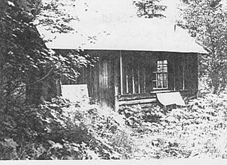
The Goathaunt Bunkhouse was built as a service structure by the Glacier Park Hotel Company for the development of the Goathaunt site in Glacier National Park. This was part of the Great Northern Railway's broader development of the park as a tourist destination. The bunkhouse is the last surviving structure of this era at this location, near the southern end of Waterton Lake. Its design has been attributed to National Park Service landscape architect Thomas Chalmers Vint.

The Glacier National Park Tourist Trails, including the Inside Trail, South Circle Trail and North Circle Trail, were established in Glacier National Park to connect a series of tourist camps and hotels established by the Great Northern Railway between 1910 and 1915. Prior to the construction of the Going-to-the-Sun Road, these trails were the primary form of circulation within the park. The trail system includes a number of bridges.
U.S. Highway 89 (US 89) is a north-south United States Numbered Highway in the state of Montana. It extends approximately 400.5 miles (644.5 km) from Yellowstone National Park north to the Canadian border. US 89 is an important tourist route within Montana as it connects Yellowstone National Park and Glacier National Park. The section of US 89 located between US 12 and US 87 is known as the Kings Hill Scenic Byway, which passes through the Little Belt Mountains in the Lewis and Clark National Forest, and is home to a wide variety of wildlife and provides many recreational opportunities for travelers along the route.

The following articles relate to the history, geography, geology, flora, fauna, structures and recreation in Glacier National Park (U.S.), the U.S. portion of the Waterton-Glacier International Peace Park.

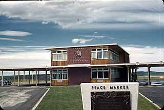
The Chief Mountain Border Station and Quarters is a customs station on the Canada–United States border in Glacier County, Montana. Located on Montana Highway 17, the station is operated seasonally, primarily for tourist traffic between Glacier National Park in Montana and Waterton Lakes National Park in Alberta. The station is named after Chief Mountain, a prominent peak in the vicinity. The station is owned by the General Services Administration and operated by U.S. Customs and Border Protection, and is located within the boundaries of Glacier National Park. The station is a notable example of the National Park Service Rustic style and is listed on the National Register of Historic Places.
The Piegan–Carway Border Crossing connects the town of Babb, Montana with Cardston, Alberta. It is reached by U.S. Route 89 on the American side and Alberta Highway 2 on the Canadian side. The crossing was established in 1925 with the completion of the Cardston Highway. Canada Customs official Herbert Legg created the name Carway by combining the words Cardston and Highway. The small village of Carway, Alberta has all but vanished, with the Carway School closing in 1954.

The Boundary Fire is a wildfire in Glacier National Park in the U.S. state of Montana. First reported in the evening of August 23, 2018, the fire is located slightly more than a mile west of Waterton Lake in the Boundary Creek Valley near Campbell Mountain. The fire straddles the international border but did not cross into Waterton Lakes National Park in Alberta, Canada. After it was detected on August 23, the fire quickly grew to more than 1,500 acres (610 ha) over the next two days but cooler and wetter weather conditions prevented significant growth after that. Firefighters were deployed to the Goat Haunt region to install sprinklers and be prepared for structure protection. By September 9 the fire was reported as being 2,896 acres (1,172 ha) and only 12 percent contained.

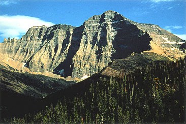
Porcupine Ridge is a prominent mountain ridge located in the Goat Haunt area of Glacier National Park, in Glacier County of the U.S. state of Montana. This mountain is part of the Livingston Range, and is situated 1.5 mile east of the Continental Divide. Topographic relief is significant as the summit rises approximately 3,900 feet (1,190 meters) above Lake Frances in one mile, and nearly 5,000 feet (1,524 meters) above Waterton Lake in five miles. Precipitation runoff from the mountain drains to the Waterton River via Olson and Valentine Creeks. This geographical feature's name was officially adopted in 1911 by the United States Board on Geographic Names.