Highwood River

Last updated
Highwood River
Highwood River AB.JPG
The Highwood from Alberta Highway 40
Location
Country Canada
Province Alberta
Physical characteristics
Source 
  location Peter Lougheed Provincial Park
  coordinates 50°36′37″N114°58′34″W / 50.61032°N 114.97613°W / 50.61032; -114.97613 (Highwood River origin)
  elevation2,500 meters (8,200 ft)
Mouth  
  location
Bow River
  coordinates
50°49′03″N113°46′44″W / 50.81743°N 113.77892°W / 50.81743; -113.77892 (Highwood River mouth)
  elevation
950 meters (3,120 ft)

The Highwood River is a tributary of the Bow River in southwestern Alberta, Canada.

Contents

Course

The Highwood River gathers water from the slopes of Mount Arethusa and flows along the Kananaskis Trail Arethusa-Storm-Mist-Highwood-aerial.JPG
The Highwood River gathers water from the slopes of Mount Arethusa and flows along the Kananaskis Trail

The Highwood originates in the Canadian Rockies in Peter Lougheed Provincial Park, in the Highwood Pass below Mount Arethusa. It flows south and is paralleled by the Kananaskis Trail between Elbow-Sheep Wildland Provincial Park, Don Getty Wildland Provincial Park, and Emerson Creek Park. It turns east and flows along Highway 541 and through the community of Longview. Continuing east, it passes through High River, ending when it enters the Bow River southeast of Calgary.

Recreation

The river is known for flyfishing. A variety of trout species live in the river, including native bull trout. In springtime when the snow is melting the river offers white water rafting.

Flooding

The Highwood River is subject to frequent flooding. Flood events of exceptional magnitude occurred in 1894, 1899, 1902, 1908, 1912, 1923, 1929, 1932, 1942, 1995, 2005 and 2013. [1] Most recently during the 2013 Alberta floods, thousands of people in Alberta were ordered to evacuate their homes after the rise of the Highwood River, Bow River, Elbow River and numerous others. [2] [3] Three people died as a result of the flooding of the Highwood River. [4]

Tributaries and features

From origin to mouth, the Highwood River receives the following tributaries or passes through these geographic features:

Tributary or featureLocationRemarks
Storm Creek 50°33′57″N114°57′11″W / 50.56597°N 114.95302°W / 50.56597; -114.95302 (Storm Creek) left tributary from Storm Mountain
Kananaskis Trail 50°32′27″N114°56′57″W / 50.54084°N 114.94909°W / 50.54084; -114.94909 (Kananaskis Trail) Bridge
Mist Creek 50°30′50″N114°50′19″W / 50.51388°N 114.83849°W / 50.51388; -114.83849 (Mist Creek) left tributary from Mist Mountain
Picklejar Creek 50°30′25″N114°49′42″W / 50.50687°N 114.82833°W / 50.50687; -114.82833 (Picklejar Creek) left tributary
Loomis Creek 50°28′02″N114°47′06″W / 50.46714°N 114.78512°W / 50.46714; -114.78512 (Loomis Creek) right tributary
McPhail Creek 50°24′59″N114°44′43″W / 50.41631°N 114.74539°W / 50.41631; -114.74539 (McPhail Creek) right tributary
Cat Creek 50°24′29″N114°42′45″W / 50.40797°N 114.71243°W / 50.40797; -114.71243 (Cat Creek) left tributary
Strawberry Creek 50°22′57″N114°40′40″W / 50.38248°N 114.67775°W / 50.38248; -114.67775 (Strawberry Creek) right tributary
Fitzsimmons Creek 50°22′45″N114°39′28″W / 50.37914°N 114.65781°W / 50.37914; -114.65781 (Fitzsimmons Creek) right tributary
Etherington Creek 50°22′46″N114°38′58″W / 50.37944°N 114.64946°W / 50.37944; -114.64946 (Etherington Cree) right tributary
Stony Creek 50°23′18″N114°37′09″W / 50.38832°N 114.61922°W / 50.38832; -114.61922 (Stony Creek) left tributary
Cataract Creek 50°23′23″N114°34′57″W / 50.38986°N 114.58254°W / 50.38986; -114.58254 (Cataract Creek) right tributary
Zephyr Creek 50°23′23″N114°34′32″W / 50.38977°N 114.57551°W / 50.38977; -114.57551 (Zephyr Creek) right tributary
Marston Creek 50°24′17″N114°30′05″W / 50.40470°N 114.50136°W / 50.40470; -114.50136 (Marston Creek) left tributary
Deep Creek 50°25′24″N114°28′12″W / 50.42343°N 114.46994°W / 50.42343; -114.46994 (Deep Creek) left tributary
Eden Valley Indian reserve 216 50°25′14″N114°28′33″W / 50.42061°N 114.47585°W / 50.42061; -114.47585 (Eden Valley start) enters reserve
Eden Valley Indian Reserve 216 50°27′31″N114°25′27″W / 50.45863°N 114.42421°W / 50.45863; -114.42421 (Eden Valley end) leaves reserve
Waldie Creek 50°28′29″N114°25′11″W / 50.47466°N 114.41978°W / 50.47466; -114.41978 (Waldie Creek) left tributary
Trap Creek 50°28′43″N114°25′10″W / 50.47849°N 114.41952°W / 50.47849; -114.41952 (Trap Creek) left tributary
Sullivan Creek 50°31′51″N114°23′06″W / 50.53074°N 114.38507°W / 50.53074; -114.38507 (Sullivan Creek) left tributary
Ings Creek 50°33′35″N114°20′13″W / 50.55979°N 114.33701°W / 50.55979; -114.33701 (Ings Creek) left tributary
Longview 50°31′59″N114°14′24″W / 50.53301°N 114.24000°W / 50.53301; -114.24000 (Longview) enters town limits
Cowboy Trail 50°31′24″N114°14′01″W / 50.52346°N 114.23348°W / 50.52346; -114.23348 (Cowboy Trail) bridge
Bull Creek 50°30′20″N114°13′58″W / 50.50548°N 114.23275°W / 50.50548; -114.23275 (Bull Creek) right tributary
Pekisko Creek 50°28′55″N114°07′42″W / 50.48207°N 114.12843°W / 50.48207; -114.12843 (Pekisko Creek) right tributary
High River 50°34′33″N113°54′21″W / 50.57573°N 113.90574°W / 50.57573; -113.90574 (High River) enters town limits
Highway 2A 50°34′59″N113°52′21″W / 50.58308°N 113.87239°W / 50.58308; -113.87239 (Highway 2A) road and railroad bridge
Tongue Creek 50°38′20″N113°52′19″W / 50.63876°N 113.87181°W / 50.63876; -113.87181 (Tongue Creek) left tributary
CPR 50°39′26″N113°51′34″W / 50.65727°N 113.85934°W / 50.65727; -113.85934 (CPR) railroad bridge
Highway 2 50°40′06″N113°51′44″W / 50.66836°N 113.86222°W / 50.66836; -113.86222 (Highway 2) bridge
Highway 547 50°41′49″N113°51′50″W / 50.69705°N 113.86396°W / 50.69705; -113.86396 (Highway 547) bridge
Sheep River 50°44′25″N113°51′21″W / 50.74024°N 113.85580°W / 50.74024; -113.85580 (Sheep River) left tributary
Highway 552 50°47′01″N113°49′17″W / 50.78368°N 113.82126°W / 50.78368; -113.82126 (Highway 552) bridge
Bow River 50°49′08″N113°46′42″W / 50.81898°N 113.77845°W / 50.81898; -113.77845 (Bow River) river mouth as right tributary of Bow River
Map all coordinates using: OpenStreetMap

See also

Related Research Articles

<span class="mw-page-title-main">Kananaskis Country</span> Multiple use area west of Calgary, Alberta, Canada

Kananaskis Country is a multi-use area west of Calgary, Alberta, Canada in the foothills and front ranges of the Canadian Rockies. The area is named for the Kananaskis River, which was named by John Palliser in 1858 after a Cree acquaintance. Covering an area of approximately 4,000 km2 (1,500 sq mi), Kananaskis Country was formed by the Alberta Government in 1978 to provide an assortment of land uses and designations. Land uses include resource extraction activities, recreation, power generation, and residential communities. Land designations include public land and protected areas.

<span class="mw-page-title-main">Bow River</span> River in Alberta, Canada

The Bow River is a river in Alberta, Canada. It begins within the Canadian Rocky Mountains and winds through the Alberta foothills onto the prairies, where it meets the Oldman River, the two then forming the South Saskatchewan River. These waters ultimately flow through the Nelson River into Hudson Bay. The Bow River runs through the city of Calgary, taking in the Elbow River at the historic site of Fort Calgary near downtown. The Bow River pathway, developed along the river's banks, is considered a part of Calgary's self-image.

<span class="mw-page-title-main">Glenmore Reservoir</span> Reservoir in Calgary, Alberta

The Glenmore Reservoir is a large reservoir on the Elbow River in the southwest quadrant of Calgary, Alberta. It is controlled by the Glenmore Dam, a concrete gravity dam on the Elbow River. The Glenmore Reservoir is a primary source of drinking water to the city of Calgary. Built in 1932, with a cost of $3.8 million, the dam controls the downstream flow of the Elbow River, thus allowing the city to develop property near the river's banks with less risk of flooding.

<span class="mw-page-title-main">Oldman River</span> River in Alberta, Canada

The Oldman River is a river in southern Alberta, Canada. It flows roughly west to east from the Rocky Mountains, through the communities of Fort Macleod, Lethbridge, and on to Grassy Lake, where it joins the Bow River to form the South Saskatchewan River, which eventually drains into the Hudson Bay.

<span class="mw-page-title-main">Elbow River</span> River in Alberta, Canada

The Elbow River is a river in southern Alberta, Canada. It flows from the Canadian Rockies to the city of Calgary, where it merges into the Bow River.

<span class="mw-page-title-main">Red Deer River</span> River in Alberta and Saskatchewan, Canada

The Red Deer River is a river in Alberta and a small portion of Saskatchewan, Canada. It is a major tributary of the South Saskatchewan River and is part of the larger Saskatchewan-Nelson system that empties into Hudson Bay.

<span class="mw-page-title-main">High River</span> Town in Alberta, Canada

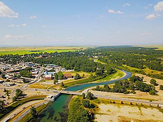
High River is a town within the Calgary Metropolitan Region of Alberta, Canada. It is approximately 68 kilometres (42 mi) south of Calgary, at the junction of Alberta Highways 2 and 23. High River had a population of 14,324 in 2021.

<span class="mw-page-title-main">Bow Valley Provincial Park</span> Provincial park in Alberta, Canada

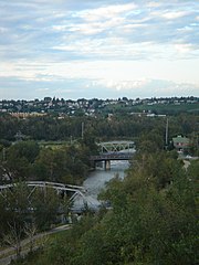
Bow Valley Provincial Park is a provincial park in Alberta, Canada. Established in 1959 in the arch of the Bow River at its confluence with the Kananaskis River, the park is one park of many within the Kananaskis Country park system.

<span class="mw-page-title-main">Sheep River (Alberta)</span> River in Alberta, Canada

The Sheep River is located in southwestern Alberta, Canada, and is part of the Bow River watershed. The river begins in the mountain valleys of Elbow-Sheep Wildland Provincial Park, passes through Sheep River Provincial Park, and joins the Highwood River about 8 km east of Okotoks. The Sheep River provides drinking water for the towns of Diamond Valley, and Okotoks.

<span class="mw-page-title-main">North Saskatchewan River</span> River in Western Canada

The North Saskatchewan River is a glacier-fed river that flows from the Canadian Rockies continental divide east to central Saskatchewan, where it joins with the South Saskatchewan River to make up the Saskatchewan River. Its water flows eventually into the Hudson Bay.

<span class="mw-page-title-main">Spray Valley Provincial Park</span> Canadian provincial park

Spray Valley Provincial Park is a provincial park located east of the Rocky Mountains, along the Spray River in western Alberta, Canada.

<span class="mw-page-title-main">Kananaskis River</span> River in Alberta, Canada

The Kananaskis River is a mountain river in western Alberta, Canada. It is a tributary of the Bow River, crossing the length of Kananaskis Country.

<span class="mw-page-title-main">Sunnyside, Calgary</span> Neighbourhood in Calgary, Alberta, Canada

Sunnyside is an innercity community in Calgary, Alberta located on the north side of the Bow River immediately adjacent to Calgary's downtown. The community partners with the neighbouring community of Hillhurst to form the Hillhurst-Sunnyside Community Association. The combined communities have an area redevelopment plan in place, revised in 2009.

The history of flooding in Canada includes floods caused by snowmelt runoff or freshet flooding, storm-rainfall and "flash flooding", ice jams during ice formation and spring break-up, natural dams, coastal flooding on ocean or lake coasts from storm surges, hurricanes and tsunamis. Urban flooding can be caused by stormwater runoff, riverine flooding and structural failure when engineered flood management structures, including dams and levees, prove inadequate to manage the quantities and force of flood waters. Floods can also occur when groundwater levels rise entering buildings cracks in foundation, floors and basements. Flooding is part of the natural environmental process. Flooding along large river systems is more frequent in spring where peak flows are often governed by runoff volume due to rainfall and snowmelt, but can take place in summer with flash floods in urban systems that respond to short-duration, heavy rainfall. Flooding due to hurricanes, or downgraded severe storms, is a concern from August to October when tropical storms can affect Eastern North America. Flood events have had a significant effect on various regions of the country. Flooding is the costliest natural disaster for Canadians. Most home insurance claims in Canada deal with water damage due to sewer back-up, not fire.

Pearce Estate Park is a city park located in Calgary, Alberta. The park occupies 21 hectares along the Bow River to the east of downtown Calgary. The park contains Pearce Estate Wetland, described as "constructed wetlands filled with native plants and animals". The land was donated to the city around 1929 by then prominent Calgarian William Pearce.

The Little Bow River is a tributary of the Oldman River in southern Alberta, Canada. It is about 190 kilometres (120 mi) long. From its headwaters near High River, it flows south, then turns east and flows into Travers Reservoir. Afterwards, it flows southeast into the Oldman River near Picture Butte. The Little Bow is related to the Bow River as they both ultimately feed the South Saskatchewan River.

<span class="mw-page-title-main">2013 Alberta floods</span> Natural disaster in southern Alberta, Canada

In the days leading up to June 19, 2013, parts of southern and central Alberta, Canada experienced heavy rainfall that triggered catastrophic flooding described by the provincial government as the worst in Alberta's history. Areas along the Bow, Elbow, Highwood, Red Deer, Sheep, Little Bow, and South Saskatchewan rivers and their tributaries were particularly affected. A total of 32 states of local emergency were declared and 28 emergency operations centres were activated as water levels rose and numerous communities were placed under evacuation orders.

<span class="mw-page-title-main">Bluerock Wildland Provincial Park</span> Protected area in southwestern Alberta, Canada

Bluerock Wildland Provincial Park is a wildland provincial park located in Kananaskis Improvement District, Alberta, Canada. It was established on 24 July 2001 and has an area of 12,719.59 hectares. The park was named for the Bluerock Creek that flows through and forms part of the western boundary of the park and Bluerock Mountain which is the creek's source. The park is included in the South Saskatchewan Region land use framework and administered by the South Saskatchewan Regional Plan. Sheep River Provincial Park and Bluerock Wildland Provincial Park are managed under the same Management Plan.

<span class="mw-page-title-main">Ghost River (Alberta)</span> River in Alberta, Canada

The Ghost River is a river in Alberta, Canada. It begins within the front ranges of the Canadian Rocky Mountains, joining the Bow River at Ghost Lake. These waters flow through Cochrane, Calgary, and ultimately into Hudson Bay. The upper reaches of the Ghost are fully protected by the Ghost River Wilderness Area.

Don Getty Wildland Provincial Park is a wildland provincial park in Kananaskis Country, Alberta, Canada. It was created on 24 July 2001 and has an area of 62,775 hectares. The park was named for the 11th premier of Alberta, Don Getty. The park was designated as part of the Special Places 2000: Alberta’s Natural Heritage initiative.

References

  1. "Little Bow Project/ Highwood Diversion Plan. Application to Construct a Water Management Project to Convey and Store Water Diverted from the Highwood River" Report of the NRCB/CEAA Joint Review Panel. Application #9601 - Alberta Public Works, Supply and Services. May 1998.
  2. Calgary neighbourhoods underwater as Bow River's rise continue
  3. "Alberta flooding claims at least 3 lives". CBC News . 2013-06-22. Archived from the original on 2013-08-25.
  4. "RCMP confirm three dead in Alberta floods that forced 100,000 to evacuate". National Post. June 22, 2013. Retrieved June 26, 2013.