Storm Mountain | |
---|---|
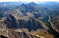
![]() Storm Mountain from Kananaskis Trail | |
Highest point | |
Elevation | 3,095 m (10,154 ft) [1] [2] [3] |
Prominence | 291 m (955 ft) [2] |
Parent peak | Mist Mountain (3139 m) [2] |
Listing | Mountains of Alberta |
Coordinates | 50°35′13″N114°56′23″W / 50.58694°N 114.93972°W [4] |
Geography | |
Country | Canada |
Province | Alberta |
Parent range | Misty Range |
Topo map | NTS 82J10 Mount Rae |
Climbing | |
Easiest route | Difficult Scramble [5] |
Storm Mountain is a mountain in Alberta's Rockies, Canada.
It is located alongside Highway 40, southwest of the Highwood Pass parking lot in Kananaskis Country, and is part of the Misty Range of the Canadian Rockies. It is identifiable as the tall peak between Mount Arethusa and Mist Mountain at the far south end of the Misty Range.
It was named by George Mercer Dawson in 1884, for the storm clouds he saw on the summit. [1] [5]
Dawson also named another peak Storm Mountain, 100 km away on the continental divide that separates Alberta and British Columbia, and Banff National Park and Kootenay National Park, to the northwest. It is unusual for two peaks of such close proximity to share the same name, especially when named by the same individual.
Mount Robson is the most prominent mountain in North America's Rocky Mountain range; it is also the highest point in the Canadian Rockies. The mountain is located entirely within Mount Robson Provincial Park of British Columbia, and is part of the Rainbow Range. Mount Robson is the second highest peak entirely in British Columbia, behind Mount Waddington in the Coast Range. The south face of Mount Robson is clearly visible from the Yellowhead Highway, and is commonly photographed along this route.
Mount Assiniboine, also known as Assiniboine Mountain, is a pyramidal peak mountain on the Great Divide, on the British Columbia/Alberta border in Canada.
The Canadian Rockies or Canadian Rocky Mountains, comprising both the Alberta Rockies and the British Columbian Rockies, is the Canadian segment of the North American Rocky Mountains. It is the easternmost part of the Canadian Cordillera, which is the northern segment of the North American Cordillera, the expansive system of interconnected mountain ranges between the Interior Plains and the Pacific Coast that runs northwest–southeast from central Alaska to the Isthmus of Tehuantepec in Mexico.
Peter Lougheed Provincial Park is in Kananaskis Country about 90 kilometres (56 mi) west of Calgary, along the Kananaskis Trail in Alberta, Canada.
The Highwood River is a tributary of the Bow River in southwestern Alberta, Canada.
Mount Rae is a mountain located on the eastern side of Highway 40 between Elbow Pass and the Ptarmigan Cirque in the Canadian Rockies of Alberta. Mount Rae was named after John Rae, explorer of Northern Canada, in 1859.
The High Rock Range is a mountain range of the Canadian Rockies in southwestern Alberta and southeastern British Columbia, Canada.
Mount Arethusa is a mountain located in the Canadian Rockies of Alberta, Canada.
Mist Mountain is a mountain located alongside Highway 40 in the Canadian Rockies of Alberta, Canada.
Mount Tyrwhitt is a mountain in British Columbia and Alberta, Canada located between Highway 40 and Elk Pass in the Elk Range of the Canadian Rockies, west of the Highwood Pass parking lot in Kananaskis Country and south east of Upper Kananaskis Lake. Located on the Continental Divide, it is also therefore on the border between British Columbia and Alberta which follows the Divide in this area.
Elbow Pass is the mountain pass between the Highwood and Elbow areas in Kananaskis Country, Alberta, Canada. It contains Elbow Lake which is the headwaters of the Elbow River.
Storm Mountain may refer to:
Highwood Pass is a mountain pass in Kananaskis Country, Alberta, Canada. It lies west of Mount Rae and Mount Arethusa of the Misty Range, south of Elbow Pass. It lies within the Peter Lougheed Provincial Park on Alberta Highway 40. The Highwood River originates in the pass.
Storm Mountain is a 3,158-metre (10,361-foot) mountain summit located on the Continental Divide on the shared border of Alberta and British Columbia in Canada. It is situated on the shared boundary of Kootenay National Park with Banff National Park in the Canadian Rockies. It is a large peak near the north end of the Ball Range, in the Bow River Valley opposite Castle Mountain. Vermilion Pass is situated to the northwest of the mountain, and Stanley Peak to the southwest. The nearest higher peak is Mount Ball, 5.7 km (3.5 mi) to the south.
The Livingstone Range is a sub-range of the Canadian Rockies in Alberta, Canada. It forms the eastern boundary of the Rockies in the south of the province. Its northern boundary is the Highwood River and it extends to Crowsnest Pass in the south. The Livingstone and Oldman Rivers bound it to the west.
Gap Mountain is a 2,675-metre (8,776-foot) mountain summit located at the southern end of the Opal Range in the Canadian Rockies of Alberta, Canada. The nearest higher neighbor is Elpoca Mountain, 2.0 km (1.2 mi) to the east. Gap Mountain is situated 5.0 km south of Mount Wintour, within Peter Lougheed Provincial Park. Gap Mountain is a conspicuous peak seen from Alberta Highway 40 at Highwood Pass. It is a popular climbing destination because it offers interesting, exposed scrambling on its eastern flanks with excellent summit views of Kananaskis Country.
Don Getty Wildland Provincial Park is a wildland provincial park in Kananaskis Country, Alberta, Canada. It was created on 24 July 2001 and has an area of 62,775 hectares. The park was named for the 11th premier of Alberta, Don Getty. The park was designated as part of the Special Places 2000: Alberta’s Natural Heritage initiative.
Mount Head is a 2,782-metre (9,127-foot) mountain summit located in Alberta, Canada.
Holy Cross Mountain is a 2,650-metre (8,694-foot) mountain summit located in Alberta, Canada.