
The South Saskatchewan River is a major river in Canada that flows through the provinces of Alberta and Saskatchewan.

Kootenay National Park is a national park of Canada located in southeastern British Columbia. The park consists of 1,406 km2 (543 sq mi) of the Canadian Rockies, including parts of the Kootenay and Park mountain ranges, the Kootenay River and the entirety of the Vermilion River. While the Vermilion River is completely contained within the park, the Kootenay River has its headwaters just outside the park boundary, flowing through the park into the Rocky Mountain Trench and eventually joining the Columbia River. The park ranges in elevation from 918 m (3,012 ft) at the southwestern park entrance to 3,424 m (11,234 ft) at Deltaform Mountain.
The Oldman River is a river in southern Alberta, Canada. It flows roughly west to east from the Rocky Mountains, through the communities of Fort Macleod, Lethbridge, and on to Grassy Lake, where it joins the Bow River to form the South Saskatchewan River, which eventually drains into the Hudson Bay.

Fish Creek Park is an urban provincial park that preserves the valley of Fish Creek in the southern part of Calgary, Alberta, Canada. It is bordered on three sides by the city, and on the west by the territory of the Tsuu T’ina Nation (Sarcee), a First Nation.

Maligne Lake is a lake in Jasper National Park, Alberta, Canada. The lake is famed for the colour of its azure water, the surrounding peaks, the three glaciers visible from the lake, and Spirit Island, a frequently and very famously photographed islet. The lake is located 44 km (27 mi) south of Jasper town, and is accessible by motor vehicle, including shuttle buses from Jasper. Boat tours run to Spirit Island in the spring to autumn season. The 44 km Skyline Trail, Jasper's most popular, highest and above treeline, multi-day hike, begins at Maligne Lake and finishes near the town of Jasper. Other popular day hikes include the Opal Hills and Bald Hills loops. Winter activities include cross-country skiing and snowboarding.
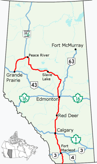
Alberta Provincial Highway No. 2, commonly referred to as Highway 2 or the Queen Elizabeth II Highway, is a major highway in Alberta that stretches from the Canada–United States border through Calgary and Edmonton to Grande Prairie. Running primarily north to south for approximately 1,273 kilometres (791 mi), it is the longest and busiest highway in the province carrying more than 170,000 vehicles per day near Downtown Calgary. The Fort Macleod—Edmonton section forms a portion of the CANAMEX Corridor that links Alaska to Mexico. More than half of Alberta's 4 million residents live in the Calgary–Edmonton Corridor created by Highway 2.

The Red Deer River is a river in Alberta and a small portion of Saskatchewan, Canada. It is a major tributary of the South Saskatchewan River and is part of the larger Saskatchewan-Nelson system that empties into Hudson Bay.

William A. Switzer Provincial Park is a provincial park in Alberta, Canada.
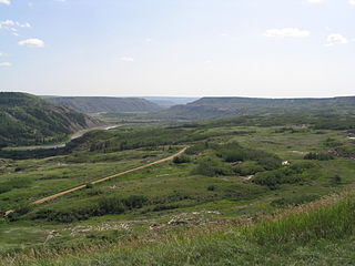
Dry Island Buffalo Jump Provincial Park is a provincial park in Central Alberta, Canada, located about 103 km (64 mi) southeast of Red Deer and 16 km (9.9 mi) east of Trochu. The park is situated along the Red Deer River and features badlands topography. Its name derives from the large plateau in the middle of the park, 200 m (660 ft) above the Red Deer River, which has never been developed by humans and retains virgin prairie grasses.

Sheep River Provincial Park is a provincial park located in Alberta, Canada, 23 kilometres (14 mi) west of Turner Valley on highway 546. It is part of the Kananaskis Country park system and encompasses a portion of the Sheep River valley.

The North Saskatchewan River is a glacier-fed river that flows from the Canadian Rockies continental divide east to central Saskatchewan, where it joins with the South Saskatchewan River to make up the Saskatchewan River. Its water flows eventually into the Hudson Bay.

The Ghost River Wilderness Area is a provincially designated wilderness area in the Canadian Rockies of Alberta protecting the headwaters of the Ghost River. It was established in 1967 and it, as one of the three Wilderness Areas of Alberta, has the strictest form of government protection available in Canada. All development is forbidden and only travel by foot is permitted. Hunting and fishing are not allowed. The other two Wilderness Areas are White Goat Wilderness Area and Siffleur Wilderness Area and together the three areas total 249,548.80 acres (100,988.82 ha).

Central Alberta is a region located in the Canadian province of Alberta.

The Blindman River is a river in south-central Alberta. It forms south of Winfield, Alberta and flows southeastward before joining the Red Deer River near Red Deer. The Blindman is bridged by Alberta Highway 20 a number of times in its upper reaches, before passing near the town of Rimbey. The river then takes on the outflow of Gull Lake. It is bridged by Alberta Highway 2 at Red Deer before flowing into the Red Deer River.
Gleniffer Lake also known as Gleniffer Reservoir or originally Lake Gleniffer is an artificial lake in central Alberta, Canada created in 1983 by the construction of the Dickson Dam which impounded the Red Deer River, a major tributary of the South Saskatchewan River which flows into the Saskatchewan River Basin.

The Medicine River is a medium-sized river in central Alberta. It begins at the outlet of Medicine Lake, north of Rocky Mountain House. The Medicine River initially travels through the Rocky Mountain House Grazing Reserve, a protected area with over 15,000 acres (61 km2) of land set aside for cattle grazing and recreation. The river flows southeast, taking on a number of creeks before passing Eckville. The Medicine River joins the Red Deer River north of Innisfail, downstream of the Dickson Dam, at the Medicine Flats. The Medicine is bridged by Alberta highways 53, 12, 11, and 54.

The Edson River is a minor river in west-central Alberta, Canada. The river, like the nearby town of Edson, is named for Edson Joseph Chamberlin (1852–1924), a Vice-President and General Manager of the Grand Trunk Pacific Railway. Chamberlain also acted as the President of the Grand Trunk Railway.
The Raven River or South Raven River is a major tributary of the Red Deer River located in Central-Western Alberta, Canada. The river is located in both the Clearwater County and Red Deer County.

The North Raven River or Stauffer Creek is a major tributary of the Raven River located in western Central Alberta, Canada. It is located in the Red Deer River system. The river is a popular place for anglers.


