Highway 27 is a provincial highway in the Canadian province of Saskatchewan. Being 34 kilometres (21 mi) long, it runs from Highway 41 at Aberdeen to Highway 2 east of Prud'homme.
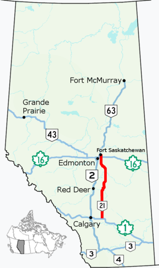
Alberta Provincial Highway No. 21, commonly referred to as Highway 21, is a north–south highway in Alberta, Canada that parallels Highway 2 between Calgary and Edmonton. It is approximately 328 kilometres (204 mi) in length. It begins at the Trans-Canada Highway (Highway 1) east of Strathmore, and ends at Fort Saskatchewan where it is succeeded by Highway 15. The northernmost 25 kilometres (16 mi) of the highway are twinned. Highway 21 runs roughly parallel to the main north–south CN rail line between Calgary and Edmonton between Three Hills and Looma.

Alberta Provincial Highway No. 12, commonly referred to as Highway 12, is an east-west highway through central Alberta. It runs from Highway 22, through Lacombe and Stettler, to the Alberta-Saskatchewan border. It generally runs parallel to Highway 13 to the north. Highway 12 is about 364 kilometres (226 mi) long.
Highway 17 is a highway in Canada that straddles and criss-crosses the Alberta–Saskatchewan provincial border. The portion from the provincial border at Dillberry Lake Provincial Park to the provincial border 800 metres (2,600 ft) north of the North Saskatchewan River is designated as Alberta Provincial Highway No. 17 by Alberta Transportation, commonly referred to as Highway 17.

Alberta Provincial Highway No. 28, commonly referred to as Highway 28, is a 293-kilometre (182 mi) highway in north-central Alberta, Canada that connects Edmonton to Cold Lake. It begins at Yellowhead Trail (Highway 16) in Edmonton as 97 Street NW, running through the city's north suburbs before entering Sturgeon County and passing CFB Edmonton. After merging with Highway 28A near Gibbons it winds through agricultural lands of north-central Alberta, roughly paralleling the North Saskatchewan River until Smoky Lake before continuing east through St. Paul County to Bonnyville. It turns northeast to CFB Cold Lake, before ending at Lakeshore Drive in the city of Cold Lake shortly thereafter.
Alberta Provincial Highway No. 55, commonly referred to as Highway 55, is a 263-kilometre (163 mi) long east–west highway in northeast Alberta, Canada. It extends from the Saskatchewan border in the east through the Cold Lake, Lac La Biche, and Athabasca where it ends at Highway 2. In Saskatchewan, it continues as Saskatchewan Highway 55.
Highway 167 is a provincial highway in the Canadian province of Saskatchewan. It runs from the Manitoba border between Creighton and Flin Flon, where it takes over from Manitoba Highway 10, to the Amiskosakahikan Indian reserve on the southern shore of Amisk Lake. It is about 49 kilometres (30 mi) long.
Highway 969 is a provincial highway in the north-east region of the Canadian province of Saskatchewan. It runs from Highway 2 to Highway 165. Highway 969 is about 115 kilometres (71 mi) long.
Highway 381 is a provincial highway in the Canadian province of Saskatchewan. It runs from Highway 80 until the Manitoba border, where it transitions into Provincial Road 547. It is about 24.5 kilometres (15.2 mi) long.
Highway 369 is a provincial highway in the Canadian province of Saskatchewan. It runs from Highway 10 near the Manitoba border to Highway 5 and Highway 357 near Togo. It is about 21 kilometres (13 mi) long.

Highway 21 is a provincial highway in the Canadian province of Saskatchewan. It runs from Montana Secondary Highway 233 at the United States border near Willow Creek to Highway 950 / Highway 919 within the Meadow Lake Provincial Park. Highway 21 is about 715 kilometres (444 mi) long.

Highway 18 is a highway in the Canadian province of Saskatchewan. It runs from Highway 13 near Robsart, approximately 65 km (40 mi) east of the Alberta border, to the Manitoba border near Gainsborough, where it becomes Highway 3. It passes through three major communities, all in the eastern quarter of Saskatchewan – Estevan, Oxbow, and Carnduff; it also passes north of the west and east blocks of Grasslands National Park. Highway 18 is about 712 km (442 mi) long, which is the longest east-west highway and second longest highway in Saskatchewan.
Highway 51 is a provincial highway in the Canadian province of Saskatchewan. It runs from the Alberta border near Compeer, Alberta, where it is preceded by Highway 12, to Highway 4 in Biggar, 1.1 kilometres (0.7 mi) south of Highway 14. Highway 51 is approximately 155 kilometres (96 mi) long. It passes through the town of Kerrobert, where it shares a 2.4 km (1.5 mi) concurrency with Highway 21 and Highway 31.

Highway 13 is a highway in the Canadian province of Saskatchewan. It runs from the Alberta border until it transitions into Highway 2 at the Manitoba border near Antler. Highway 13 is about 676 km (420 mi.) long. Highway 13 passes through Shaunavon, Assiniboia, Weyburn, Redvers and Carlyle. It is also referred to as the Red Coat Trail, as much of its length follows the route of the original historic path. A majority of the route between Wauchope and Govenlock going through the Palliser's Triangle is also referred to as the Ghost Town Trail.
Highway 371 is a provincial highway in the Canadian province of Saskatchewan. It runs from the Alberta border, where it continues as Alberta Highway 537, to Highway 21 near Fox Valley. It is about 41 kilometres (25 mi) long.
Highway 55 is a paved, undivided provincial highway in the Canadian province of Saskatchewan. It runs from the Alberta border west of Pierceland to Highway 9 near Mountain Cabin. Highway 55 is about 652 kilometres (405 mi) long and forms part of the interprovincial Northern Woods and Water Route.
Alberta Provincial Highway No. 501, commonly referred to as Highway 501, is a highway in the province of Alberta, Canada. It runs west–east from Highway 5 east of Mountain View as gravel to Cardston, then pavement through Del Bonita and Milk River to Highway 879, then gravel again to the Saskatchewan border.

Highway 47 is a provincial highway in the Canadian province of Saskatchewan. The highway runs from North Dakota Highway 40 at the Canada–United States border until Highway 49 near Preeceville. It is about 358 kilometres (222 mi) long — 64 kilometres (40 mi) of which is unpaved from the Moose Mountain Creek crossing north until the intersection with Highway 1.
Alberta Provincial Highway No. 16X, commonly referred to as Highway 16X, is the designation of one former and three proposed routes off Highway 16 in Alberta, Canada. The former section was a 36 km (22 mi) east–west provincial highway in Edmonton Capital Region, that existed for approximately 20 years between the 1970s and 1997 and is now part of Highway 16. Right of way is set aside around Hinton, Edson, and Lloydminster that is presently designated as Highway 16X.
