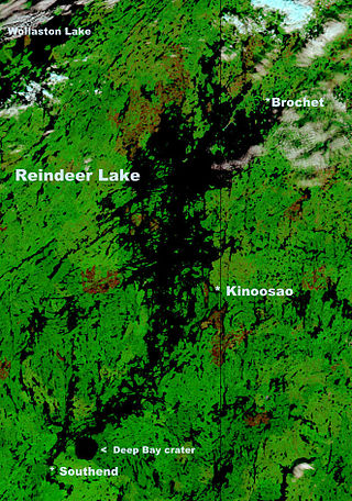
Reindeer Lake is a large lake in Western Canada located on the border between north-eastern Saskatchewan and north-western Manitoba, with the majority in Saskatchewan. The name of the lake appears to be a translation of the Algonquian name. It is the 24th largest lake in the world by area, as well as being the second-largest lake in Saskatchewan and the ninth largest in Canada. Eight percent of the lake lies in Manitoba while 92% of the lake is in Saskatchewan.

Cumberland House is a community in Census Division No. 18 in northeast Saskatchewan, Canada on the Saskatchewan River. It is the oldest community in Saskatchewan and has a population of about 2,000 people. Cumberland House Provincial Park, which provides tours of an 1890s powder house built by the Hudson's Bay Company, is located nearby.

Wollaston Lake is a lake in the north-eastern part of the Canadian province of Saskatchewan. It is about 550 kilometres (340 mi) north-east of Prince Albert. With a surface area of 2,286 square kilometres (883 sq mi), it is the largest bifurcation lake in the world — that is, a lake that drains naturally in two directions.

Highway 135 is a provincial highway in the Canadian province of Saskatchewan. It runs from Highway 106 near Jan Lake to Sandy Bay. It is about 121 kilometres (75 mi) long.
Highway 945 is a provincial highway in the Canadian province of Saskatchewan. It runs from Highway 24 near Chitek Lake to Highway 943 near Island Lake. It is about 25 kilometres (16 mi) long. The highway provides access to several provincial recreational sites.
Highway 952 is a provincial highway in the Canadian province of Saskatchewan. It runs from Highway 263 to Highway 953. It is about 18 kilometres (11 mi) long.
Highway 953 is a provincial highway in the Canadian province of Saskatchewan. It runs from Highway 952 to Highway 2. It is about 32 kilometres (20 mi) long.
Highway 913 is a provincial highway in the Canadian province of Saskatchewan. It runs from Highway 120 to the Hanson Lake Road. The southern terminus of the highway is 9.9 kilometres (6.2 mi) north of Candle Lake Provincial Park, and the northern terminus is within the Narrow Hills Provincial Park and 15.2 kilometres (9.4 mi) north from the Narrow Hills Provincial Park campground area. It is about 65.1 kilometres (40.5 mi) long and connects with Highway 963 and has a concurrency with Highway 912. The highway is gravel for its entire length.
Highway 924, also known as Elaine Lake Road, is a provincial highway in the north-west region of the Canadian province of Saskatchewan. It runs from Highway 55 near Cowan Dam Recreation Site at the source of the Cowan River to the community of Dore Lake on Doré Lake. The highway connects with Highway 916. It is about 64 kilometres (40 mi) long.
Highway 155 is a paved, undivided provincial highway in the Canadian province of Saskatchewan. It runs from Highway 55 near Green Lake until La Loche, where it intersects with Highway 955. The highway services several communities and provincial recreation sites and is entirely within the Northern Saskatchewan Administration District. It is about 299 kilometres (186 mi) long.
Highway 165 is a provincial highway in the Canadian province of Saskatchewan. It runs from Highway 155 east to Highway 106 and has a 20-kilometre (12 mi) concurrency with Highway 2.
Highway 106, also known as the Hanson Lake Road, is a fully paved provincial highway in the Canadian province of Saskatchewan. It runs from Highway 55 at Smeaton to Highway 167 in Creighton. It is about 325 kilometres (202 mi) long and the speed limit is 100 km/h (62 mph).
Highway 302 is a provincial highway in the Canadian province of Saskatchewan. It runs from the northern terminal of the Weldon Ferry, which connects to Highway 682 across the South Saskatchewan River, to a dead end near the Nisbet Provincial Forest. It is about 72 kilometres (45 mi) long.
Highway 38 is a provincial highway in the south-east portion of the Canadian province of Saskatchewan. It runs north from Kuroki to Chelan providing access to Greenwater Lake Provincial Park and Kelvington. Highway 38 is a primary highway that is paved in its entirety and maintained by the provincial government. It is approximately 89 kilometres (55 mi) long.
Highway 40 is a provincial highway in the north-west portion of the Canadian province of Saskatchewan connecting Alberta to Highway 3, four kilometres (2.5 mi) west of Shellbrook, Saskatchewan. Areas of this highway between the Alberta border and North Battleford are called the Poundmaker Trail. Pitikwahanapiwiyin, commonly known as Poundmaker, was a Plains Cree chief known as a peacemaker and defender of his people. This is a primary Saskatchewan highway maintained by the provincial government. The highway is about 280 kilometres (174 mi) long and is entirely paved.
Highway 55 is a paved, undivided provincial highway in the Canadian province of Saskatchewan. It runs from the Alberta border west of Pierceland to Highway 9 near Mountain Cabin. Highway 55 is about 652 kilometres (405 mi) long and forms part of the interprovincial Northern Woods and Water Route.

The Rural Municipality of Meadow Lake No. 588 is a rural municipality (RM) in the Canadian province of Saskatchewan within Census Division No. 17 and SARM Division No. 6.
Highway 905 is a provincial highway in the far north region of the Canadian province of Saskatchewan. It runs from Highway 102 to Stony Rapids. It is about 469 kilometres (291 mi) long and is entirely unpaved. A 185-kilometre (115 mi) section between Points North Landing and Black Lake is a seasonal winter road.

The Rural Municipality of Moose Range No. 486 is a rural municipality (RM) in the Canadian province of Saskatchewan within Census Division No. 14 and SARM Division No. 4.
Cumberland Island, also known as Pine Island, is a small island in the Saskatchewan River Delta in the east-central region of the Canadian province of Saskatchewan. The Saskatchewan River Delta is one of the largest active inland deltas in North America. Cumberland Island is situated between Cumberland Lake to the north and the Saskatchewan River to the south. The Tearing River runs along the eastern edge of the island and Bigstone River along the western edge. The Bigstone River separates Cumberland Island from Spruce Island to the west. The island is in the Mid-Boreal Lowland region, which consists of mixed coniferous and deciduous forests of white and black spruce, jack pine, tamarack, trembling aspen, balsam poplar, and balsam fir.
