
Nipawin is a town in Saskatchewan, Canada, on the Saskatchewan River portion of Tobin Lake. The town lies between Codette Lake, created by the Francois-Finlay Dam and Tobin Lake, created by the E.B. Campbell Dam built in 1963, renamed from Squaw Rapids. The construction of Francois-Finlay Dam earned Nipawin the nickname the "Town of Two Lakes".

Wollaston Lake is a lake in north-eastern part of the Canadian province of Saskatchewan. It is about 550 kilometres (340 mi) north-east of Prince Albert. With a surface area of 2,286 square kilometres (883 sq mi), it is the largest bifurcation lake in the world – that is, a lake that drains naturally in two directions.

Highway 35 is a paved undivided provincial highway in the Canadian province of Saskatchewan.. It runs from the US Border near Port of Oungre to a dead end near the north shore of Tobin Lake. Saskatchewan Highway 35 (SK Hwy 35) is about 569 kilometres (354 mi) long. The CanAm Highway comprises Saskatchewan Highways 35, SK Hwy 39, SK Hwy 6, SK Hwy 3, SK Hwy 2 and U.S. Route 85. 74.6 kilometres (46.4 mi) of SK Hwy 35 contribute to the CanAm Highway between Port of Oungre on the Canada – United States border and Weyburn. Mudslides, and spring flooding were huge road building and maintenance problems around Nipawin as well as along the southern portion of the route named the Greater Yellow Grass Marsh. Over 20 early dams were built until the problem was addressed with the Rafferty-Alameda Project on the Souris River and the construction of the Qu'Appelle River Dam which have helped to eliminate washed out roads and flooded communities. The highway through the homesteading community followed the Dominion Land Survey on the square until reaching the Saskatchewan River at Nipawin. The completion of the combined railway and traffic bridge over the Saskatchewan River at Nipawin in the late 1920s retired the ferry and basket crossing for traffic north of Nipawin. The E.B. Campbell Dam built in 1963 northeast of Nipawin created Tobin Lake, and Codette Lake was formed with the construction of the Francois-Finlay Hydroelectric dam at Nipawin. The railway/traffic bridge that formed part of Highway 35 was the only crossing utilized at Nipawin until a new traffic bridge was constructed in 1974. The new bridge then became part of the combined Highway 35 and 55 until the highway parts just east of White Fox. Highway 35 then continued north along the west side of Tobin Lake. The railway/traffic bridge continues to be utilized for one lane vehicle traffic controlled by traffic lights, and continues as the "old highway 35" on the west side of the river until it joins with the current Highway 35/55.
Candle Lake is a reservoir in the central part of the Canadian province of Saskatchewan in the boreal forest, approximately 80 kilometres (50 mi) north-east of Prince Albert. A dam completed in 1979 at the southern end of the lake regulates water levels; several small creeks feed into the lake and Torch River flows out of the lake at the dam. Candle Lake Provincial Park surrounds most of the lake and the resort village of Candle Lake is at the southern end.

Meadow Lake Provincial Park is a northern boreal forest provincial recreational park along the Waterhen and Cold Rivers in the Canadian province of Saskatchewan. The park was founded on 10 March 1959, is the largest provincial park in Saskatchewan, and encompasses over 25 lakes in an area of 1,600 km2 (620 sq mi). The park was named "Meadow Lake" after the city of Meadow Lake and Meadow Lake. The city and the lake are not in the park and are located about 40 kilometres (25 mi) south-east of the nearest park entrance, which is about 5 kilometres (3.1 mi) north of Dorintosh. The length of the park stretches about 113 kilometres (70 mi) from Cold Lake on the Saskatchewan / Alberta border in the west to the eastern shore of Waterhen Lake in the east.
Fishing Lake is a closed basin freshwater lake in the Canadian province of Saskatchewan. The lake is 22 kilometres (14 mi) north of the town of Foam Lake, and 24 kilometres (15 mi) east of the town of Wadena and is accessed from Highways 5 and 310. The northern and eastern shore is in the RM of Sasman No. 336 and the southern and western shore is in the RM of Foam Lake No. 276. The north-east portion of the lake–on the east side of McCormick Bay–is designated as Fishing Lake Wildlife Refuge.

Narrow Hills Provincial Park is a northern boreal forest provincial recreational park in the Canadian province of Saskatchewan. It is located in a hilly plateau called the Cub Hills and contains several recreational facilities and over 25 accessible lakes within its boundaries. The geographical features of the park, including the lakes, valleys, and lowlands were formed over 10,000 years ago during the last ice age. The town of Smeaton is the closest community and it is located 70 kilometres (43 mi) to the south.

The Rural Municipality of Moose Range No. 486 is a rural municipality (RM) in the Canadian province of Saskatchewan within Census Division No. 14 and SARM Division No. 4.
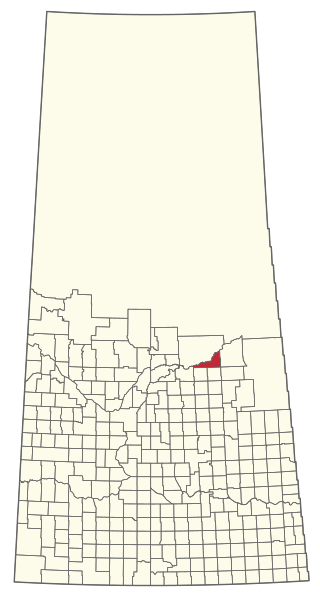
The Rural Municipality of Nipawin No. 487 is a rural municipality (RM) in the Canadian province of Saskatchewan within Census Division No. 14 and SARM Division No. 4.

Lac La Ronge Provincial Park is located in the boreal forest of the north central part of the Canadian province of Saskatchewan within the Canadian Shield. Situated in the Churchill River system, this provincial park has close to 100 lakes and more than 30 canoe routes, many of which follow old fur trade routes. Summer activities include camping, hiking, boating, fishing, and swimming. In the winter, there's cross-country skiing, snowmobiling, and ice fishing. Saskatchewan's highest waterfall is in the park. Nistowiak Falls are located north of Lac La Ronge along the Rapid River.
Greenwater Lake Provincial Park is a provincial park in the Canadian province of Saskatchewan. It is located on the eastern side of the province in the Porcupine Hills on Highway 38. The closest town, Porcupine Plain, is about 28 kilometres (17 mi) to the north-east of the park visitor centre. Founded on 19 February 1932, Greenwater is one of the oldest provincial parks in Saskatchewan. The original six parks were established in 1931 and Greenwater Provincial Park was added one year later. In 1964, the park was expanded to its current size.
Waterhen Lake is a lake in Meadow Lake Provincial Park in the Canadian province of Saskatchewan, located about 40 km (25 mi) north of the city of Meadow Lake. The lake is situated along the course of the Waterhen River in the boreal forest ecozone of Canada.
Porcupine Hills Provincial Park is the newest provincial park in the Canadian Province of Saskatchewan. It was created in 2018 through the amalgamation of five pre-existing provincial recreation sites south-east of the town of Hudson Bay. The park is in the Porcupine Provincial Forest in the Porcupine Hills, which is a geographical feature in eastern Saskatchewan and western Manitoba. The hills are part of a range of hills called the Manitoba Escarpment.

Flotten Lake is a lake in Meadow Lake Provincial Park in the Canadian Province of Saskatchewan. While the lake has one outflow, Flotten River, there are several small inflow creeks, including Fleury Creek, Young Creek, Ross Creek, Moloney Creek, and Salt Creek. Flotten River exits the lake at the south end and flows south into Waterhen Lake, which is the source of the Waterhen River.
Lac des Îles is a lake in Meadow Lake Provincial Park in the Canadian Province of Saskatchewan in the boreal forest ecozone of Canada. The primary inflow is the Cold River and its outflow is the Waterhen River. The lake and associated rivers are part of the Hudson Bay drainage basin as the Waterhen River flows into Beaver River, which meets the Churchill River, a major river that flows into Hudson Bay, at Lac Île-à-la-Crosse.
Lower Fishing Lake is a lake in the east-central part of the Canadian province of Saskatchewan in Narrow Hills Provincial Park. It is situated in the Cub Hills and the boreal forest ecozone of Canada. The lake is accessed from Highway 920, which connects to Hanson Lake Road and Highway 120. The Fishing Lakes Fire of 1977 burned much of the region upstream and around the lake and now the area is now dominated by jack pine, which is a tree species that is well adapted fire burned forests.
Great Blue Heron Provincial Park is a recreational park in the central region of the Canadian province of Saskatchewan in the boreal forest ecozone of Canada. It is adjacent to the eastern boundary of Prince Albert National Park, about 50 kilometres (31 mi) north of the city of Prince Albert. The provincial park was established in 2013 from two pre-existing provincial recreation sites – Emma Lake and Anglin Lake Recreation Sites – and the addition of a large tract of Crown land.
Wapiti Valley Regional Park is a ski resort and regional park in the Canadian province of Saskatchewan. It is in the Saskatchewan River Valley on the shores of Codette Lake in the rural municipalities of Nipawin No. 487 and Torch River No. 488 on the edge of the Fort à la Corne Provincial Forest. The park, which opened in 1984, is a ski resort in the winter and a campground in the summer. Access is from Highway 6.
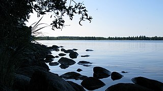
Codette Lake, which was named after Métis fur trader Baptiste Codette, is a reservoir in the Canadian province of Saskatchewan. The lake was created in 1986 with the construction of the Francois-Finlay Dam across the Saskatchewan River about 5 kilometres (3.1 mi) upstream from the town of Nipawin. The dam is the site of the Nipawin Hydroelectric Station. Downsteam from Codette Lake is Tobin Lake, which is another man-made lake along the course of the Saskatchewan River that was created in 1963 with the construction of the E.B. Campbell Dam.
Delaronde Lake is a lake in the Canadian province of Saskatchewan. It is situated at the western edge of the Waskesiu Upland in the boreal forest ecozone of Canada. Delaronde Lake is within the Churchill River drainage basin of the Hudson Bay.


