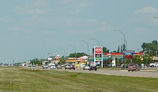
Martensville is a city located in Saskatchewan, Canada, just 8 kilometres (5.0 mi) north of Saskatoon, 10 kilometres (6.2 mi) west of the city of Warman and 14 kilometres (8.7 mi) southwest of Clarkboro Ferry which crosses the South Saskatchewan River. It is a bedroom community of Saskatoon. It is surrounded by the Rural Municipality of Corman Park No. 344. The community is served by the Saskatoon/Richter Field Aerodrome located immediately west of the city across Highway 12, as well as by Saskatoon's John G. Diefenbaker International Airport, only a few miles to the south.
Provincial Trunk Highway 16 (PTH 16) is a provincial highway in the Canadian province of Manitoba. It is the Manitoba section of the Yellowhead Highway, and also the Trans-Canada Highway Yellowhead section. The main purpose of this highway is to connect Winnipeg with other Canadian cities such as Saskatoon and Edmonton. The highway runs from Bloom at an intersection with the Trans-Canada Highway and Provincial Road 305 ten kilometres (6.2 mi) west of Portage la Prairie to the Saskatchewan boundary sixteen kilometres (9.9 mi) west of Russell, where it continues as Saskatchewan Highway 16.
Highway 27 is a provincial highway in the Canadian province of Saskatchewan. The highway runs from Highway 41 west of Aberdeen east to Highway 2 near the western shore of Muskiki Lake. It is about 34 kilometres (21 mi) long.

Highway 16 is a provincial highway in the Canadian province of Saskatchewan. It is the Saskatchewan section of the Yellowhead Highway, and also the Trans-Canada Highway Yellowhead section. The main purpose of this highway is to connect Saskatchewan with Canadian cities such as Edmonton and Winnipeg. The highway runs from the Alberta boundary in Lloydminster to the Manitoba boundary near Marchwell. Major cities it passes through are Saskatoon, North Battleford in the central part of the province, Yorkton in the far east and Lloydminster to the far west.

Highway 19 and Highway 625 are two provincial highways south of Edmonton in the Canadian province of Alberta that form a continuous east–west route connecting Highway 60 near Devon to Highway 21 east of Beaumont. Highway 19 was acquired by the City of Edmonton in the land annexation approved by the Province in 2019. Highway 19 passes north of the Edmonton International Airport and, in tandem with Highway 60, provides a southwest bypass of Edmonton between Highways 2 and 16. East of Highway 2, Highway 19 becomes Highway 625 and continues through Nisku Industrial Park. It intersects Highway 814 in Beaumont before ending at Highway 21.

Alberta Provincial Highway No. 39, commonly referred to as Highway 39, is an east–west highway in central Alberta, Canada. It extends from Highway 22, approximately 13 kilometres (8 mi) east of Drayton Valley, to Leduc where it ends at Highway 2. Highway 39 is about 91 kilometres (57 mi) long.
Ring Road is a 4 lane controlled access highway in Regina, Saskatchewan, Canada. Ring Road is a partial ring road or beltway that forms a partial circle around Regina, bypasses the city on the north, east, and south sides, with Lewvan Drive and Pasqua Street N functioning as the de facto western leg. East of Pasqua Street, Ring Road continues west as 9th Avenue N, an arterial road. Ring Road has a speed limit of 100 km/h (60 mph) and consists of 13 interchanges.
Provincial Trunk Highway 5 is a provincial primary highway located in the Canadian province of Manitoba.

Warman (/ˈwɔrmən/) is the ninth-largest city in the Canadian province of Saskatchewan. It is located approximately 20 kilometres (12 mi) north of the city of Saskatoon, and 5 kilometres (3.1 mi) northeast of the city of Martensville. According to the 2021 census, Warman is the fastest growing municipality in Saskatchewan, and was the fastest growing municipality in Canada between 2011 and 2016. Warman is a bedroom community of Saskatoon. The current mayor is Gary Philipchuk.
Highway 11 is a major north-south highway in Saskatchewan, Canada that connects the province's three largest cities: Regina, Saskatoon, and Prince Albert. It is a structural pavement major arterial highway which is approximately 391 kilometres (243 mi) long. It is also known as the Louis Riel Trail (LRT) after the 19th century Métis leader. It runs from Highway 1 in Regina until Highway 2 south of Prince Albert. Historically the southern portion between Regina and Saskatoon was Provincial Highway 11, and followed the Dominion Survey lines on the square, and the northern portion between Saskatoon and Prince Albert was Provincial Highway 12.

Highway 5 is a major highway in the Canadian province of Saskatchewan. It begins in downtown Saskatoon and runs eastward to the Manitoba border near Togo, where it becomes Provincial Road 363. The highway is approximately 393 kilometres (244 mi) long. Between the early 1900s (decade) and 1976, Provincial Highway 5 was a trans-provincial highway travelling approximately 630 kilometres (390 mi) in length. At this time it started at the Alberta border in Lloydminster and traveled east to the Manitoba border.
Highway 12 is a major highway in the Canadian province of Saskatchewan. It begins in Saskatoon at the intersection of Idylwyld Drive and Highway 11 north, initially running north on Idylwyld Drive concurrently with Highway 11 and Highway 16. Just outside Saskatoon's northern city limits, Highway 11 exits northeast from Idylwyld Drive and Highway 12 begins and travels north, passing through the city of Martensville. Highway 12 cross the North Saskatchewan River over Petrofka Bridge and passes through the town of Blaine Lake and intersects highway Highway 40, finally terminating at Highway 3 near Shell Lake. Highway 12 is about 135 km (84 mi) long.

Saskatchewan, the middle of Canada's three prairie provinces, has an area of 588,276.09 square kilometres (227,134.67 sq mi) and population of 1,150,632, mostly living in the southern half of the province.

Highway 41 is a provincial highway in the Canadian province of Saskatchewan. It runs from Highway 5 in Saskatoon to Highway 3 / Highway 6 in Melfort. The highway also intersects Highway 2. It is about 163 kilometres (101 mi) long.

Highway 39 is a provincial highway in the southern portion of the Canadian province of Saskatchewan. It runs from North Portal at the Canada–United States border north-west to Moose Jaw at Highway 1. This is a primary Saskatchewan highway maintained by the provincial and federal governments that provides a major trucking and tourism route between U.S. Route 52 and the Trans-Canada Highway.

Highway 47 is a provincial highway in the Canadian province of Saskatchewan. The highway runs from North Dakota Highway 40 at the Canada–United States border until Highway 49 near Preeceville. It is about 358 kilometres (222 mi) long — 64 kilometres (40 mi) of which is unpaved from the Moose Mountain Creek crossing north until the intersection with Highway 1.

Highway 48 is a provincial highway in the Canadian province of Saskatchewan. The highway runs from the Trans-Canada Highway at White City east to the Manitoba — Saskatchewan border. It is about 238 kilometres (148 mi) long. Highway 48 was originally numbered as Highway 16 until the mid-1970s.
Alberta Provincial Highway No. 16X, commonly referred to as Highway 16X, is the designation of one former and three proposed routes off Highway 16 in Alberta, Canada. The former section was a 36 km (22 mi) east–west provincial highway in Edmonton Capital Region, that existed for approximately 20 years between the 1970s and 1997 and is now part of Highway 16. Right of way is set aside around Hinton, Edson, and Lloydminster that is presently designated as Highway 16X.
The Saskatoon Freeway is a proposed four-lane limited access highway in and adjacent to Saskatoon, Saskatchewan. The 55-kilometre (34 mi) route will connect Highway 11 (south) with Highway 7, forming a partial ring road around the city of Saskatoon. When complete, it will serve as a replacement bypass route for the existing Circle Drive.


