
Drumheller is a town within the Red Deer River valley in the badlands of east-central Alberta, Canada. It is located 110 kilometres (68 mi) northeast of Calgary, and 97 kilometres (60 mi) south of Stettler. The Drumheller portion of the Red Deer River valley, often referred to as Dinosaur Valley, has an approximate width of 2 kilometres (1.2 mi) and an approximate length of 28 kilometres (17 mi).

Olds-Didsbury-Three Hills is a provincial electoral district in Alberta, Canada. The district is one of 87 districts mandated to return a single member (MLA) to the Legislative Assembly of Alberta using the first past the post method of voting.

Alberta Provincial Highway No. 9, commonly referred to as Highway 9, is a highway in south-central Alberta, Canada, which together with Saskatchewan Highway 7 connects Calgary to Saskatoon, Saskatchewan via Drumheller. It is designated as a core route of the National Highway System, forming a portion of an interprovincial corridor. Highway 9 spans approximately 324 km (201 mi) from the Trans-Canada Highway east of Calgary to Alberta's border with Saskatchewan.

Endiang, Alberta is a hamlet in Alberta, Canada within the County of Stettler No. 6. It is located approximately 80 kilometres (50 mi) southeast of Stettler, Alberta.
The Drumheller Institution is a medium-security prison operated in Drumheller, Alberta by the Correctional Service of Canada. It was opened in 1967, and also includes a 72-bed minimum-security facility. As of 6 April 2004, the medium security section had a rated capacity of 598.
Byemoor is a hamlet in Alberta, Canada within the County of Stettler No. 6. It is located at the intersection of Highway 853 and Highway 589, approximately 70 kilometres (43 mi) southeast of Stettler and 80 kilometres (50 mi) northeast of Drumheller. It has an elevation of 845 metres (2,772 ft).

Rosebud, Alberta is a hamlet in southern Alberta, Canada within Wheatland County. Previously an incorporated municipality, Rosebud dissolved from village status on January 1, 1946 to become part of the Municipal District of Grasswold No. 248.

Horseshoe Canyon is a region of badlands surrounded by prairie in the province of Alberta, Canada. It is located about 17 km west of Drumheller, Alberta, along Highway 9.

The "World's Largest Dinosaur" is the name of a model Tyrannosaurus rex located in the town of Drumheller in the Canadian province of Alberta. Built of fiberglass and steel, it has a height of 26.3 metres (86 ft) and a length of 46 metres (151 ft), considerably larger than the largest known specimens of the actual dinosaur which reached up to 12.8 m (42 ft) in length, and up to 4 m (13 ft) tall at the hips.
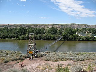
The Star Mine Suspension Bridge is a 117 metre long pedestrian suspension bridge across the Red Deer River in Drumheller, Alberta, Canada. Constructed in 1931, it was built for the coal workers of Star Mine. In 1958, the Alberta provincial government rebuilt the bridge to "commemorate part of the colourful mining history of the Drumheller Valley."
The Dinosaur Trail is a circular tourist route in the province of Alberta, Canada, located in the Canadian badlands paralleling the Red Deer River on both sides, from Drumheller to the Bleriot Ferry. It is divided in two segments, with the South Dinosaur Trail following the south side of the river and uses portions of Highway 575 and Highway 837, while North Dinosaur Trail follows the north side of the river and is the entirety of Highway 838. The north and south segments of Dinosaur Trail are connected by the Highway 9 / Highway 56 concurrency within Drumheller.
Alberta Provincial Highway No. 838, commonly referred to as Highway 838, is a short highway in central Alberta, Canada. It runs from Highway 837 across the Red Deer River on the free, cable-operated Bleriot Ferry to Highway 9 / Highway 56 in Drumheller. Outside of Drumheller, Highway 838 does not pass through any communities. All of Highway 838 is part of the Dinosaur Trail and is known as North Dinosaur Trail.

Rowley is a hamlet In Alberta, Canada within Starland County. It is located just north of Drumheller.
Hesketh is a hamlet in southern Alberta, Canada within Kneehill County. It is located approximately 25 km (16 mi) west of Drumheller.
Chancellor is a hamlet in southern Alberta, Canada within Wheatland County. It is located approximately 26 kilometres (16 mi) north of Highway 1 and 86 kilometres (53 mi) east of Calgary.
Finnegan is an unincorporated community in southern Alberta in Special Area No. 2, located 14 kilometres (8.7 mi) west of Highway 36, 64 kilometres (40 mi) northwest of Brooks.
Pelican Point is a hamlet in central Alberta, Canada within Camrose County. It is located approximately 6 kilometres (3.7 mi) south of Highway 53 and 55 kilometres (34 mi) south of Camrose.

Scandia is a hamlet in Alberta, Canada within the County of Newell. It is located 2 kilometres (1.2 mi) west of Highway 36, approximately 34 kilometres (21 mi) southwest of Brooks.

Horsethief Canyon is found 16 kilometres (9.9 mi) northwest of the town of Drumheller, in Starland County in the province of Alberta, Canada. It is on the east bank of the Red Deer River, along Highway 838. Both Horsethief Canyon and Horseshoe Canyon are distinctive features of the surrounding badlands of central Alberta. Although the two canyons look similar, they are separated by several kilometres and were created by different tributaries of the Red Deer River.
The Crowfoot Ferry is a cable ferry in near Crowfoot, Alberta, Canada. It links the two sections of Range Road 201 as it crosses the Bow River from Wheatland County on the north, to Vulcan County on the south, within the Siksika Nation. Originally opened in 1927, It is located 5 kilometres (3 mi) south of the Highway 1 / Highway 56 intersection and is maintained by Alberta Transportation. The ferry suffered considerable damage during the 2013 Alberta floods and was out of operation for four years while it was rebuilt.
