Regional Municipality of Wood Buffalo

Last updated
Wood Buffalo
Regional Municipality of Wood Buffalo
Seal of Wood Buffalo, Alberta.svg
AB locator REGIONAL MUNICIPALITY OF WOOD BUFFALO.svg
Location within Alberta
CountryCanada
Province Alberta
Region Northern Alberta
Planning region Lower Athabasca
Specialized municipality April 1, 1995
Name changeAugust 14, 1996
Administrative office Fort McMurray
Government
[1]
  MayorSandy Bowman
  Governing body
Wood Buffalo Municipal Council
  • Mike Allen
  • Krista Balsom
  • John Bruce Inglis
  • Sheila Lalonde
  • Nicholas Keith McGrath
  • Phillip John Meagher
  • Verna Francine Murphy
  • Jeff Peddle
  • Jane Stroud
  • Claris Voyageur
  CAOJamie Doyle
Area
 (2021) [2]
  Land60,843.88 km2 (23,491.95 sq mi)
Population
 (2021) [2]
  Total82,400
  Density1.2/km2 (3/sq mi)
   Municipal census (2021)
75,555 [3]
Time zone UTC−7 (MST)
  Summer (DST) UTC−6 (MDT)
Website rmwb.ca

The Regional Municipality of Wood Buffalo (abbreviated RMWB) [4] [5] is a specialized municipality in northeast Alberta, Canada. It is the largest municipality in North America by area [6] and is home to oil sand deposits known as the Athabasca oil sands.

Contents

History

The Municipality of Wood Buffalo was incorporated as a specialized municipality on April 1, 1995 as a result of the amalgamation of the City of Fort McMurray and Improvement District No. 143. [7] Specialized municipality status was granted to provide "for the unique needs of a municipality including a large urban centre and a large rural territory with a small population." [7] The Municipality of Wood Buffalo subsequently changed its name to the Regional Municipality of Wood Buffalo on August 14, 1996. [7]

June 2013 floods

By June 12, 2013, after many days of heavy rain, the Regional Municipality of Wood Buffalo declared a state of emergency. They organized evacuations from some areas and placed others under boil water advisories as local waterways, such as the Hangingstone River, rose to dangerously elevated levels 30 kilometres (19 mi) south of Fort McMurray, causing the closure of Highway 63. [8]

2016 wildfire

From May 3, 2016 on, over 80,000 people were affected by evacuations, by May 3 at 6:49 pm, the entirety of Fort McMurray and surrounding areas were placed under a mandatory evacuation. [9] [10] making it Alberta's largest evacuation for a wildfire. [9]

April 2020 floods

By April 30, 2020, after a 25-kilometre-long ice jam formed in the Athabasca River, flooding the northern Alberta city's downtown and surrounding areas, and forcing 13,000 people from their home, Fort McMurray's spring flood caused more than $520 million in insured damage, according to new numbers from the Insurance Bureau of Canada. That flood damage was followed by $1.2 billion in damage from a hailstorm in Calgary, Airdrie and Rocky View County, flooding in Edmonton in July and another storm in Calgary on July 24.

Geography

The Regional Municipality (RM) of Wood Buffalo is in the northeast corner of the province of Alberta. [11] It borders the province of Saskatchewan to the east; the Northwest Territories to the north; Improvement District No. 24 (Wood Buffalo National Park), Mackenzie County, and the Municipal District of Opportunity No. 17 to the west; and Athabasca County and the Municipal District of Bonnyville No. 87 to the south. [11] The Athabasca River meanders northward through the central portion of the RM of Wood Buffalo before emptying into Lake Athabasca. [11] Some of its water bodies include Christina Lake, Gardiner Lakes, Garson Lake, Gipsy Lake, Gordon Lake, Gregoire Lake, McClelland Lake, Namur Lake, Richardson Lake, and Winefred Lake (also partially within Lac La Biche County and the Municipal District of Bonnyville No. 87). [11] Discharging northward from Lake Athabasca is Riviere des Rochers, which at its confluence with the Peace River becomes the Slave River. [11] The Slave River forms much of the RM of Wood Buffalo's boundary with Improvement District No. 24 north of the confluence. Land formations include the Birch Mountains northwest of Fort McKay, Fort Hills north of Fort McKay, and Thickwood Hills west of Fort McMurray. [11] A portion of the Peace-Athabasca Delta is also within the RM of Wood Buffalo. [11]

Communities and localities

The following localities are located within the Regional Municipality of Wood Buffalo: [13]

  • Almac Subdivision
  • Beaver Lake-Young's Beach
  • Bechtel Syncrude Camp
  • Berdinskies
  • Berny
  • Big Eddy
  • Billos
  • Bitumount
  • Brièreville
  • Chard [14]
  • Charron
  • Cheecham
  • Christina Crossing
  • Corbetts
  • Devenish
  • Dog Head
  • Draper
  • Egg Lake
  • Embarras
  • Embarras Portage
  • Fitzgerald [14]
  • Fitzgerald 196
  • Fitzgerald Settlement
  • Fort Smith Settlement
  • Gourin
  • Grandin
  • Improvement District No.143
  • Kenny Woods
  • Kinosis
  • Le Goff
  • Leismer
  • Lenarthur
  • Lynton
  • Maloy
  • Mariana Lake
  • Mildred Lake
  • Old Fort
  • Pelican Settlement
  • Pingle
  • Point Brule
  • Quigley
  • Rossian
  • Sandy Rapids
  • Tar Island
  • Waterways
  • Willow Trail
  • Wolyn

The following settlements are within the Regional Municipality of Wood Buffalo: [11]

  • Chipewyan
  • Fitzgerald (Smith Landing)
  • Janvier South
  • Mariana
  • McKay
  • St. Bruno Farm (also partially within Improvement District No. 24)

First Nations have the following Indian reserves within the Regional Municipality of Wood Buffalo: [11]

Hydrology

The Regional Municipality of Wood Buffalo (RMWB) is in the lower basin of the Athabasca River watershed and Fort McMurray is the largest community on the banks of the river. [notes 1] Local rivers include the Hangingstone River, Clearwater River and Christina River, a tributary of the Clearwater River.

The Hangingstone River drains an area of 1,070 km2 (413 sq mi), which is dominated by muskeg,[ citation needed ] and flows into the Clearwater River just upstream of the Athabasca River at Fort McMurray. [15] The river often experiences high flows in the spring during snow melt, during heavy rainfall events and when ice jams occur during spring ice break. The RMWB warns citizens of the potential for sudden flash floods "especially in populated areas adjacent to the Athabasca River, Clearwater River and Christina River." Water levels have been monitored by the Water Survey of Canada since 1970 (WSC station 07CD004). During the spring months there is increased monitoring of the "Clearwater River to the south of the urban service area to provide warning of an ice break" and the "Athabasca River upper basin, local river levels, precipitation and overall weather patterns." [16]

The Clearwater River, [notes 2] [17] designated as part of the Canadian Heritage Rivers System, flows 187 km (116 mi) from its headwaters at Lloyd Lake in northwest Saskatchewan into northeast Alberta before joining the Athabasca River at Fort McMurray. [17] [18] "The lack of significant oil sands developments means that the Clearwater River can be used as a baseline river system to provide information on the variability and characteristics of natural systems." [18]

Demographics

Federal census
population history
YearPop.±%
199136,771    
1996 35,213−4.2%
2001 41,466+17.8%
2006 51,496+24.2%
2011 65,565+27.3%
2016 71,594+9.2%
2021 72,326+1.0%
Source: Statistics Canada [19] [20] [21] [22] [23] [2]

Federal census

In the 2021 Census of Population conducted by Statistics Canada, the Regional Municipality of Wood Buffalo had a population of 72,326 living in 25,934 of its 30,451 total private dwellings, a change of

In the 2016 Census of Population conducted by Statistics Canada, the Regional Municipality of Wood Buffalo had a population of 71,594 living in 25,659 of its 30,713 total private dwellings, a change of

Municipal census

Regional Municipality of Wood Buffalo population breakdown, 2021 [3]
ComponentPermanent
 population 
Shadow
 population 
Combined
 population 
Urban service area (Fort McMurray)   72,9173,08976,006
Rural service area2,63827,41530,053
Total RM of Wood Buffalo75,55530,053106,059

The permanent population of the Regional Municipality (RM) of Wood Buffalo according to its 2021 municipal census is 75,555, [3] a change of

Ethnicity

Panethnic groups in the Regional Municipality of Wood Buffalo (2001−2021)
Panethnic group2021 [25] 2016 [26] 2011 [27] 2006 [28] 2001 [29]
Pop. %Pop.%Pop.%Pop.%Pop.%
European [lower-alpha 1] 44,02045,84547,02040,43033,615
Indigenous 8,1356,5656,3155,3655,130
Southeast Asian [lower-alpha 2] 6,3605,3652,790880465
African 4,8254,1752,070720340
South Asian 4,7704,9804,0851,780640
Middle Eastern [lower-alpha 3] 1,5051,9401,215830475
East Asian [lower-alpha 4] 8651,285845695520
Latin American 6459251,03557075
Other/multiracial [lower-alpha 5] 650400295140105
Total responses71,78071,48065,56551,40541,360
Total population72,32671,59465,56551,49641,466
Note: Totals greater than 100% due to multiple origin responses

Language

Immigration

Wood Buffalo is home to almost 2,000 recent immigrants (arriving between 2001 and 2006) who now make up more than 3% of the population. About 21% of these immigrants came from India, while about 10% came from each of Pakistan and the Philippines, and about 9% came from Venezuela, and about 8% from South Africa, about 6% from China, and about 3% came from Colombia. [32]

Religion

More than 80% of residents identified as Christian at the time of the 2001 census while almost 17% indicated they had no religious affiliation. For specific denominations Statistics Canada counted 15,880 Roman Catholics (37.4%), 4,985 Anglicans (11.7%), 4,225 for the United Church of Canada (9.9%), 1,730 Pentecostals (4.1%), 1,195 Baptists (2.8%), 965 for the Salvation Army (2.3%), 900 Lutherans (2.1%), 690 Muslims (1.6%), 350 Latter-day Saints (0.8%), and 320 Presbyterians (0.8%). [33]

Economy

The Regional Municipality of Wood Buffalo is home to vast oil sand deposits, also known as the Athabasca Oil Sands, helping to make the region one of the fastest growing industrial areas in Canada.

Attractions

Wood Buffalo National Park is adjacent to the Regional Municipality (RM) of Wood Buffalo to the northwest. [11] The following provincial protected areas are also within the RM of Wood Buffalo: [11]

Government

The municipality's current mayor is Sandy Bowman, who was first elected in 2021. Its first mayor upon its creation in 1995 was Guy Boutilier, who had previously been the mayor of Fort McMurray and was subsequently elected as the region's provincial MLA. Doug Faulkner served as mayor from 1997 to 2004, and Melissa Blake from 2004 to 2017.

In the Legislative Assembly of Alberta, the municipality was served by the electoral district of Fort McMurray-Wood Buffalo until 2010, when a second district, Fort McMurray-Conklin, was created due to population growth. The new riding then became Fort McMurray-Lac La Biche in 2018.

Fort McMurray-Wood Buffalo is currently represented by Tany Yao and Fort McMurray-Lac La Biche is represented by Brian Jean. Both MLAs are former members of the Wildrose Party and are current members of the United Conservative Party.

As of 2016, the municipality is located in the federal electoral district of Fort McMurray—Cold Lake. The riding has been represented in the House of Commons of Canada by former UCP MLA for Fort McMurray-Lac La Biche Laila Goodridge of the Conservative Party of Canada since 2021.

See also

Notes

  1. Statistic includes all persons that did not make up part of a visible minority or an indigenous identity.
  2. Statistic includes total responses of "Filipino" and "Southeast Asian" under visible minority section on census.
  3. Statistic includes total responses of "West Asian" and "Arab" under visible minority section on census.
  4. Statistic includes total responses of "Chinese", "Korean", and "Japanese" under visible minority section on census.
  5. Statistic includes total responses of "Visible minority, n.i.e." and "Multiple visible minorities" under visible minority section on census.
  1. The Athabasca River originates in Jasper National Park. It is fed by the Athabasca Glacier within the Columbia Icefield, at an altitude of approximately 1,600 metres (5,200 ft). The river travels 1,231 km (765 mi) before discharging through the Mackenzie River system into the Arctic Ocean through the Northwest Territories. Its course is marked by rapids, impeding navigation southwest of Fort McMurray.
  2. Clearwater river is named because of its "unspoiled, clear-water river in a pristine isolated "wilderness setting of spectacular beauty."

Related Research Articles

<span class="mw-page-title-main">Athabasca River</span> Canadian river in Alberta

The Athabasca River is a river in Alberta, Canada, which originates at the Columbia Icefield in Jasper National Park and flows more than 1,231 km (765 mi) before emptying into Lake Athabasca. Much of the land along its banks is protected in national and provincial parks, and the river is designated a Canadian Heritage River for its historical and cultural importance. The scenic Athabasca Falls is located about 30 km (19 mi) upstream from Jasper.

<span class="mw-page-title-main">Fort McMurray</span> Place in Alberta, Canada

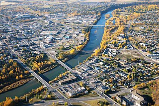
Fort McMurray is an urban service area in the Regional Municipality of Wood Buffalo in Alberta, Canada. It is located in northeast Alberta, in the middle of the Athabasca oil sands, surrounded by boreal forest. It has played a significant role in the development of the national petroleum industry. The 2016 Fort McMurray wildfire led to the evacuation of its residents and caused widespread damage.

<span class="mw-page-title-main">Fort Chipewyan</span> Hamlet in Alberta, Canada

Fort Chipewyan, commonly referred to as Fort Chip, is a hamlet in northern Alberta, Canada, within the Regional Municipality (RM) of Wood Buffalo. It is located on the western tip of Lake Athabasca, adjacent to Wood Buffalo National Park, approximately 223 kilometres (139 mi) north of Fort McMurray.

<span class="mw-page-title-main">Fort Smith, Northwest Territories</span> Town in Northwest Territories, Canada

Fort Smith is a town in the South Slave Region of the Northwest Territories (NWT), Canada. It is located in the southeastern portion of the Northwest Territories, on the Slave River and adjacent to the Alberta border along the 60th parallel north.

<span class="mw-page-title-main">Division No. 16, Alberta</span> Census division in Alberta, Canada

Division No. 16 is a census division in Alberta, Canada. It is located in the northeast portion of northern Alberta and surrounds the Urban Service Area of Fort McMurray.

<span class="mw-page-title-main">Lac La Biche County</span> Specialized municipality in Alberta, Canada

Lac La Biche County is a specialized municipality within Division No. 12 in northern Alberta, Canada. It was established through the amalgamation of the Town of Lac La Biche and Lakeland County in 2007.

<span class="mw-page-title-main">Mackenzie County</span> Specialized municipality in Alberta, Canada

Mackenzie County is a specialized municipality in northern Alberta, Canada. It is located in Census Division 17, along the Mackenzie Highway. The municipal office is located in the hamlet of Fort Vermilion.

<span class="mw-page-title-main">Northern Alberta</span> Geographic region of Alberta, Canada

Northern Alberta is a geographic region located in the Canadian province of Alberta.

<span class="mw-page-title-main">Fort McKay</span> Indian settlement and hamlet in Alberta, Canada

Fort McKay or Fort MacKay is a community in northeast Alberta, Canada that is located at the confluence of the Athabasca and MacKay rivers. It is approximately 54 km (34 mi) north of Fort McMurray via Highway 63 and Fort McKay Road. The community has an elevation of 260 m (850 ft).

Calling Lake is a hamlet in northern Alberta, Canada within the Municipal District of Opportunity No. 17. It is located on Highway 813 along the eastern shore of Calling Lake, immediately north of Calling Lake Provincial Park. It is approximately 59 km (37 mi) north of Athabasca and 113 km (70 mi) south of Wabasca and has an elevation of 595 m (1,952 ft).

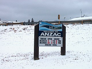
Anzac is a hamlet in northern Alberta, Canada within the Regional Municipality (RM) of Wood Buffalo. It is located on Highway 881 along the east shore of Gregoire Lake, approximately 36 kilometres (22 mi) southeast of Fort McMurray.

Conklin is a hamlet in northern Alberta, Canada within the Regional Municipality (RM) of Wood Buffalo. It is located on Highway 881 between Fort McMurray and Lac La Biche. It lies near the west end of Christina Lake at an elevation of 575 metres (1,886 ft), and was named for John Conklin, a railroad employee.

Gregoire Lake Estates is a hamlet in northern Alberta, Canada within the Regional Municipality (RM) of Wood Buffalo. It is located on Highway 881, approximately 30 kilometres (19 mi) southeast of Fort McMurray.

Waterways is a locality within the Regional Municipality of Wood Buffalo in northern Alberta, Canada. It is now a neighbourhood within the Fort McMurray urban service area along the west bank of the Clearwater River, south of the river's confluence with the Athabasca River.

Gipsy-Gordon Wildland Park is a wildland provincial park in northern Alberta, Canada. The park was establisher on 20 December 2000 and is 35,766.3 hectares in size. The Government of Alberta announced its creation through its approval of the Lower Athabasca Regional Plan Land Use Framework in November 2000.

<span class="mw-page-title-main">2012 Alberta municipal censuses</span>

Alberta has provincial legislation allowing its municipalities to conduct municipal censuses between April 1 and June 30 inclusive. Municipalities choose to conduct their own censuses for multiple reasons such as to better inform municipal service planning and provision, to capitalize on per capita based grant funding from higher levels of government, or to simply update their populations since the last federal census.

<span class="mw-page-title-main">Improvement District No. 24</span> Improvement district in Alberta, Canada

Improvement District No. 24, or Improvement District No. 24 , is an improvement district in Alberta, Canada. Coextensive with the portion of Wood Buffalo National Park in northeast Alberta, the improvement district provides local governance for lands within the park that are not within Indian reserves.

<span class="mw-page-title-main">2015 Alberta municipal censuses</span>

Alberta has provincial legislation allowing its municipalities to conduct municipal censuses between April 1 and June 30 inclusive. Municipalities choose to conduct their own censuses for multiple reasons such as to better inform municipal service planning and provision, to capitalize on per capita based grant funding from higher levels of government, or to simply update their populations since the last federal census.

<span class="mw-page-title-main">Fort McMurray-Lac La Biche</span> Provincial electoral district in Alberta, Canada

Fort McMurray-Lac La Biche is a current provincial electoral district in Alberta, Canada. The district will be one of 87 districts mandated to return a single member (MLA) to the Legislative Assembly of Alberta using the first past the post method of voting. It was contested for the first time in the 2019 Alberta election.

References

  1. "Municipal Officials Search". Alberta Municipal Affairs. May 9, 2019. Retrieved October 1, 2021.
  2. 1 2 3 4 "Population and dwelling counts: Canada, provinces and territories, and census subdivisions (municipalities)". Statistics Canada. February 9, 2022. Retrieved February 9, 2022.
  3. 1 2 3 4 "Municipal Census Report" (PDF). Regional Municipality of Wood Buffalo. 2021. p. 9. Retrieved May 5, 2022.
  4. "Website Abbreviation". Regional Municipality of Wood Buffalo. Retrieved May 8, 2016.
  5. "RMWB @RMWoodBuffalo Twitter Profile". Twitter. Regional Municipality of Wood Buffalo. Retrieved May 8, 2016.
  6. "Population and dwelling counts, for Canada and census subdivisions (municipalities), 2006 and 2001 censuses - 100% data". Statistics Canada. January 6, 2010. Retrieved October 3, 2011.
  7. 1 2 3 "Location and History Profile – Regional Municipality of Wood Buffalo" (PDF). Alberta Municipal Affairs. October 15, 2021. Retrieved October 17, 2021.
  8. "Fort McMurray floodwaters wash out roads, power. Some residents are moved out, others ready for evacuation order". CBC News. June 12, 2013.
  9. 1 2 Parsons, Paige (May 3, 2016). "Thousands flee from Fort McMurray wildfire in the largest fire evacuation in Alberta's history". Postmedia Network. Edmonton Journal . Retrieved May 3, 2016.
  10. "Wildfire destroys Fort McMurray homes, most of city evacuated". CBC News Edmonton. May 3, 2016. Retrieved May 3, 2016.
  11. 1 2 3 4 5 6 7 8 9 10 11 2021 Provincial Base Map: Municipalities (PDF) (Map). Alberta Environment and Parks. July 26, 2021. Retrieved October 17, 2021.
  12. 1 2 "Specialized and Rural Municipalities and Their Communities" (PDF). Alberta Municipal Affairs. January 12, 2022. Retrieved January 21, 2022.
  13. "Standard Geographical Classification (SGC) 2006, Economic Regions: 4816037 - Wood Buffalo, geographical codes and localities, 2006". Statistics Canada. March 5, 2010. Archived from the original on March 23, 2012. Retrieved August 11, 2012.
  14. 1 2 Geo-Administrative Areas (Hamlet, Locality and Townsite Culture Points) (Geodatabase layer) (Map). AltaLIS. October 26, 2020. Retrieved October 2, 2021.
  15. Hangingstone River Hydrological Profile (Report). Hydrology of the Athabasca Oil Sands Region. Regional Aquatics Monitoring Program RAMP. Retrieved June 11, 2013.
  16. "Floods? Are You Ready?" (PDF). Wood Buffalo. Retrieved June 11, 2013.
  17. 1 2 "Clearwater River". Canadian Heritage Rivers System. Retrieved June 11, 2013.
  18. 1 2 "Clearwater River Hydrological Profile". Hydrology of the Athabasca Oil Sands Region. Regional Aquatics Monitoring Program (RAMP. Retrieved June 11, 2013.
  19. "Table 10: Population and Dwelling Counts, for Census Divisions, Census Subdivisions (Municipalities) and Designated Places, 1991 and 1996 Censuses – 100% Data". 96 Census. Vol. A National Overview – Population and Dwelling Counts. Ottawa: Statistics Canada. 1997. pp. 136–146. ISBN   0-660-59283-5.
  20. "Population and Dwelling Counts, for Canada, Provinces and Territories, and Census Divisions, 2001 and 1996 Censuses - 100% Data (Alberta)". Statistics Canada . Retrieved 2013-02-16.
  21. "Population and dwelling counts, for Canada, provinces and territories, and census subdivisions (municipalities), 2006 and 2001 censuses - 100% data (Alberta)". Statistics Canada. 2010-01-06. Retrieved 2013-02-16.
  22. "Population and dwelling counts, for Canada, provinces and territories, and census subdivisions (municipalities), 2011 and 2006 censuses (Alberta)". Statistics Canada. February 8, 2012. Retrieved February 8, 2012.
  23. 1 2 "Population and dwelling counts, for Canada, provinces and territories, and census subdivisions (municipalities), 2016 and 2011 censuses – 100% data (Alberta)". Statistics Canada. February 8, 2017. Retrieved February 8, 2017.
  24. 1 2 "census2018: Municipal Census Report" (PDF). Regional Municipality of Wood Buffalo. 2018. Retrieved May 1, 2021.
  25. Government of Canada, Statistics Canada (2022-10-26). "Census Profile, 2021 Census of Population". www12.statcan.gc.ca. Retrieved 2023-04-06.
  26. Government of Canada, Statistics Canada (2021-10-27). "Census Profile, 2016 Census". www12.statcan.gc.ca. Retrieved 2023-04-06.
  27. Government of Canada, Statistics Canada (2015-11-27). "NHS Profile". www12.statcan.gc.ca. Retrieved 2023-04-06.
  28. Government of Canada, Statistics Canada (2019-08-20). "2006 Community Profiles". www12.statcan.gc.ca. Retrieved 2023-04-06.
  29. Government of Canada, Statistics Canada (2019-07-02). "2001 Community Profiles". www12.statcan.gc.ca. Retrieved 2023-04-06.
  30. "Census Profile, 2016 Census Wood Buffalo, Specialized municipality [Census subdivision], Alberta and Division No. 16, Census division [Census division], Alberta". 8 February 2017.
  31. "Census Profile, 2016 Census Wood Buffalo, Specialized municipality [Census subdivision], Alberta and Division No. 16, Census division [Census division], Alberta". 8 February 2017.
  32. "Wood Buffalo". Immigrant Status and Period of Immigration (8) and Place of Birth (261) for the Immigrants and Non-permanent Residents of Canada, Provinces, Territories, Census Metropolitan Areas and Census Agglomerations, 2006 Census - 20% Sample Data. Statistics Canada. December 4, 2007. Retrieved February 6, 2008.
  33. "Wood Buffalo". Religion (95A), Age Groups (7A) and Sex (3) for Population, for Canada, Provinces, Territories, Census Metropolitan Areas and Census Agglomerations, 1991 and 2001 Censuses - 20% Sample Data. Statistics Canada. March 1, 2007. Retrieved February 6, 2008.