Alberta is one of the thirteen provinces and territories of Canada. It is a part of Western Canada and is one of the three prairie provinces. Alberta borders British Columbia to the west, Saskatchewan to the east, the Northwest Territories to the north, and the U.S. state of Montana to the south. It is one of the only two landlocked provinces in Canada, with Saskatchewan being the other. The eastern part of the province is occupied by the Great Plains, while the western part borders the Rocky Mountains. The province has a predominantly continental climate but experiences quick temperature changes due to air aridity. Seasonal temperature swings are less pronounced in western Alberta due to occasional Chinook winds.

Fort McMurray is an urban service area in the Regional Municipality of Wood Buffalo in Alberta, Canada. It is located in northeast Alberta, in the middle of the Athabasca oil sands, surrounded by boreal forest. It has played a significant role in the development of the national petroleum industry. The 2016 Fort McMurray wildfire led to the evacuation of its residents and caused widespread damage.

Fort Chipewyan, commonly referred to as Fort Chip, is a hamlet in northern Alberta, Canada, within the Regional Municipality (RM) of Wood Buffalo. It is located on the western tip of Lake Athabasca, adjacent to Wood Buffalo National Park, approximately 223 kilometres (139 mi) north of Fort McMurray.

Jasper is a specialized municipality and townsite in western Alberta within the Canadian Rockies. The townsite is in the Athabasca River valley and is the commercial centre of Jasper National Park.
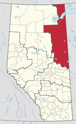
The Regional Municipality of Wood Buffalo is a specialized municipality in northeast Alberta, Canada. It is the largest regional municipality in Canada by area and is home to oil sand deposits known as the Athabasca oil sands.

Athabasca County is a municipal district in north central Alberta, Canada. It is located northeast of Edmonton and is in Census Division No. 13. Prior to an official renaming on December 1, 2009, Athabasca County was officially known as the County of Athabasca No. 12.

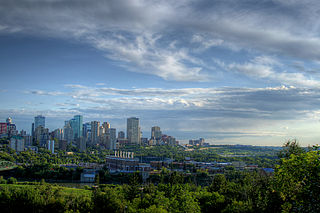
The Edmonton Metropolitan Region (EMR), also commonly referred to as Greater Edmonton or Metro Edmonton, is a conglomeration of municipalities centred on Edmonton, the capital of the Canadian province of Alberta.
Birch Mountains Wildland Provincial Park is a wildland provincial park in northern Alberta, Canada. The park was established on 20 December 2000 with an area of 144,505 hectares. On 14 May 2018, the park was enlarged slightly to an area of 145,969 hectares. Thye park was created as part of Alberta's "Special Places" initiative. The park is contained in the Lower Athabasca Region Land Use Framework finalized in 2012. It contains a free roaming wood bison herd. The park is named for the Birch Mountains that are partially contained within the boundaries of the park.
Kazan Wildland Provincial Park is a wildland provincial park in northern Alberta, Canada. It was established on 14 May 2018 and is a large park with an area of 659,397 hectares (2,546 sq mi). As of January 2023, Kazan is the largest park under Alberta provincial authority. The park was initiated by and is contained in the Lower Athabasca Regional Plan Land Use Framework in August 2012. Two smaller parks, La Butte Creek and Colin-Cornwall Lakes Wildland Provincial Parks, were disestablished and incorporated into Kazan.
Richardson Wildland Park is a wildland provincial park in the Regional Municipality of Wood Buffalo, northern Alberta, Canada. It was established 14 May 2018 and has an area of 312,068 hectares (1,204.90 sq mi). Two previous parks, Maybelle River Wildland Provincial Park and Richardson River Dunes Wildland Provincial Park, established in 1998, were disestablished on 14 May 2018 and the area was incorporated into Richardson Wildland Park. The park is within the Lower Athabasca Region Land Use Framework and managed within the Lower Athabasca Regional Plan.
Gipsy-Gordon Wildland Park is a wildland provincial park in northern Alberta, Canada. The park was establisher on 20 December 2000 and is 35,766.3 hectares in size. The Government of Alberta announced its creation through its approval of the Lower Athabasca Regional Plan Land Use Framework in November 2000.
Dillon River Wildland Provincial Park is a wildland provincial park in northern Alberta, Canada. It was established on 14 May 2018 and has an area of 191,545 hectares. The Government of Alberta announced the park's creation through its approval of the Lower Athabasca Regional Plan Land Use Framework in August 2012.

The Upper Peace Region is a land-use framework region in northern Alberta, Canada. One of seven in the province, each is intended to develop and implement a regional plan, complementing the planning efforts of member municipalities in order to coordinate future growth. Corresponding roughly to major watersheds while following municipal boundaries, these regions are managed by Alberta Environment and Parks.

The Red Deer Region is a land-use framework region in Alberta, Canada. One of seven in the province, each is intended to develop and implement a regional plan, complementing the planning efforts of member municipalities in order to coordinate future growth. Corresponding roughly to major watersheds while following municipal boundaries, these regions are managed by Alberta Environment and Parks.

The Lower Peace Region is a land-use framework region in northern Alberta, Canada. One of seven in the province, each is intended to develop and implement a regional plan, complementing the planning efforts of member municipalities in order to coordinate future growth. Corresponding roughly to major watersheds while following municipal boundaries, these regions are managed by Alberta Environment and Parks.
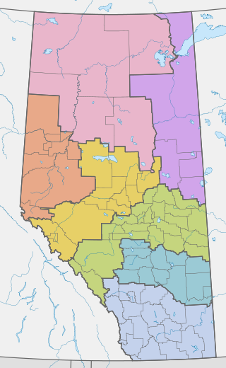
Land-use framework regions are a scheme of organizing local governments adopted by the Canadian province of Alberta. Numbering seven in total, each land-use region is named for, and roughly follows the boundary of, a major watershed. Managed by Alberta Environment and Parks, the stated aims of the program are to create a venue for regionwide planning and cooperation, promoting sustainable use of public and private lands. Every region is intended to develop and enact its own comprehensive regional land-use plan, guiding future development within its territory. However, as of 2019, approved plans have only been submitted from two of the seven regions.

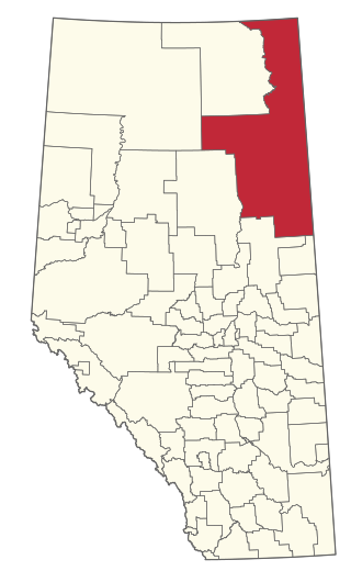
The Upper Athabasca Region is a land-use framework region in northern Alberta, Canada. One of seven in the province, each is intended to develop and implement a regional plan, complementing the planning efforts of member municipalities in order to coordinate future growth. Corresponding roughly to major watersheds while following municipal boundaries, these regions are managed by Alberta Environment and Parks.
The North Saskatchewan Region is a land-use framework region in northern Alberta, Canada. One of seven in the province, each is intended to develop and implement a regional plan, complementing the planning efforts of member municipalities in order to coordinate future growth. Corresponding roughly to major watersheds while following municipal boundaries, these regions are managed by Alberta Environment and Parks.

The South Saskatchewan Region is a land-use framework region in southern Alberta, Canada. One of seven in the province, each is intended to develop and implement a regional plan, complementing the planning efforts of member municipalities in order to coordinate future growth. Corresponding roughly to major watersheds while following municipal boundaries, these regions are managed by Alberta Environment and Parks.
Birch River Wildland Provincial Park is a wildland provincial park in northern Alberta, Canada. It was established on 14 May 2018 and covers 331,832 hectares (1,281.2 sq mi).The park is contained in the Lower Athabasca Region Land Use Framework finalized in 2012. The park is named for the Birch River that flows through it.