List of settlements in Alberta

Last updated

A settlement in Alberta is a subdivided area of land that was surveyed prior to the establishment of the Third System of Survey under the Dominion Land Survey. [1] Settlements do not necessarily fit within the Alberta Township Survey grid system. [1]

Contents

List of settlements

Alberta has 47 unique settlements according to Alberta Boundary Data. [2] Most settlements are in rural areas while some are located within or adjacent to urban areas.

Settlement Specialized or
rural municipality
 
Urban
municipality
 
First Nation or
Métis settlement
 
Remarks 
Athabasca Landing Settlement Athabasca County Athabasca   
Atikamisis Lake Settlement Big Lakes County and
Northern Sunrise County
  Utikoomak Lake 155
and Gift Lake Metis Settlement
 
Big Prairie Settlement Big Lakes County   Pakashan 150D  
Boyer Settlement Mackenzie County    
Chipewyan Settlement Wood Buffalo, RM of   Dog Head 218  
Cline Settlement Clearwater County    
Dunvegan Settlement Fairview No. 136, MD of
and Birch Hills County
   
Fitzgerald (Smith Landing) Settlement Wood Buffalo, RM of   Thebathi 196  
Flyingshot Lake Settlement Grande Prairie No. 1, County of Grande Prairie   
Footner Settlement Mackenzie County    
Fort Saskatchewan Settlement Sturgeon County Fort Saskatchewan  Includes all or a portion of the Hamlet of Lamoureux
Fort Vermilion Settlement Mackenzie County   Fort Vermilion 173B Includes all or a portion of the Hamlet of Fort Vermilion
Grande Cache Lake Settlement Greenview No. 16, MD of    
Grande Cache Settlement Greenview No. 16, MD of    
Heart River and Salt Prairie Settlement Big Lakes County   Halcro 150C  
Janvier South Settlement Wood Buffalo, RM of   Includes all or a portion of the Hamlet of Janvier South
Joachim Settlement Greenview No. 16, MD of    
Lac La Biche Settlement Lac La Biche County   Includes all or a portion of the Hamlet of Lac La Biche
Lac Ste. Anne Settlement Lac Ste. Anne County Alberta Beach and
Sunset Point
  
Lesser Slave Lake Settlement Big Lakes County   Freeman 150B Includes all or a portion of the Hamlet of Grouard
Little Buffalo Lake Settlement Northern Sunrise County   Includes all or a portion of the Hamlet of Little Buffalo
Lobstick Settlement Smoky Lake County    
Mariana Settlement Wood Buffalo, RM of    
McKay Settlement Wood Buffalo, RM of   Includes all or a portion of the Hamlet of Fort McKay
McMurray Settlement Wood Buffalo, RM of   Includes a portion of the Urban Service Area of Fort McMurray
Morleyville Settlement Bighorn No. 8, MD of Ghost Lake   
Muskeeg-Seepee Settlement Greenview No. 16, MD of    
North Vermilion Settlement Mackenzie County    
North Zama Settlement Mackenzie County   Includes all or a portion of the Hamlet of Zama City
Otauwau Settlement Lesser Slave River No. 124, MD of    
Peace River Landing Settlement Northern Sunrise County Peace River   
Pelican Settlement Opportunity No. 17, MD of    
Red Earth Settlement Opportunity No. 17, MD of   Includes all or a portion of the Hamlet of Red Earth Creek
Sandy Lake Settlement Opportunity No. 17, MD of   Includes all or a portion of the Hamlet of Sandy Lake
Shaftesbury Settlement Peace No. 135, MD of Peace River   
Spirit River Settlement Spirit River No. 133, MD of    
St. Albert Settlement Sturgeon County and
Parkland County
St. Albert   
St. Bruno Farm Wood Buffalo, RM of
and ID No. 24
   
Steen River Settlement Mackenzie County    
Susa Creek Settlement Greenview No. 16, MD of    
Tugate Settlement Mackenzie County    
Victor Lake Settlement Greenview No. 16, MD of    
Victoria Settlement Smoky Lake County    
Wabiskaw Settlement Opportunity No. 17, MD of   Includes all or a portion of the Hamlet of Wabasca
Wanyandie Flats East Settlement Greenview No. 16, MD of    
Wanyandie Flats West Settlement Greenview No. 16, MD of    
Ya-Ha-Tinda Ranch Clearwater County    

See also

Related Research Articles

<span class="mw-page-title-main">Township</span> Designation for types of settlement as administrative territorial entities

A township is a form of human settlement or administrative subdivision. Its exact definition varies among countries.

Statistics Canada, formed in 1971, is the agency of the Government of Canada commissioned with producing statistics to help better understand Canada, its population, resources, economy, society, and culture. It is headquartered in Ottawa.

<span class="mw-page-title-main">Unincorporated area</span> Region of land not governed by own local government

An unincorporated area is a region that is not governed by a local municipal corporation. There are many unincorporated communities and areas in the United States and Canada. Most other countries have very few or no unincorporated areas.

<span class="mw-page-title-main">Hamlet (place)</span> Small human settlement in a rural area

A hamlet is a human settlement that is smaller than a town or village. This is often simply an informal description of a smaller settlement or possibly a subdivision or satellite entity to a larger settlement.

<span class="mw-page-title-main">Manning, Alberta</span> Town in Alberta, Canada

Manning is a town in northern Alberta, Canada. It is known as the "Land of the Mighty Moose". It is located on Highway 35 on the Notikewin River, approximately 73 km (45 mi) north of Peace River.

<span class="mw-page-title-main">New Norway</span> Hamlet in Alberta, Canada

New Norway is a hamlet located in central Alberta, Canada within Camrose County. Named in 1895, it is located on Highway 21, approximately 100 km (62 mi) southeast of Edmonton and 22 km (14 mi) southwest of Camrose.

<span class="mw-page-title-main">Crowsnest Pass, Alberta</span> Specialized municipality in Alberta, Canada

The Municipality of Crowsnest Pass is a specialized municipality in southwest Alberta, Canada. Within the Rocky Mountains adjacent to the eponymous Crowsnest Pass, the municipality formed as a result of the 1979 amalgamation of five municipalities – the Village of Bellevue, the Town of Blairmore, the Town of Coleman, the Village of Frank, and Improvement District No. 5, which included the Hamlet of Hillcrest and numerous other unincorporated communities.

<span class="mw-page-title-main">Didsbury, Alberta</span> Town in Alberta, Canada

Didsbury is a town in central Alberta, Canada at the foothills of the Rocky Mountains. It is located next to Alberta Highway 2A, near the Queen Elizabeth II Highway. Didsbury is within the Calgary-Edmonton corridor. Didsbury is approximately the half-way point between the cities of Calgary and Red Deer.

<span class="mw-page-title-main">Chestermere</span> City in Alberta, Canada

Chestermere, originally named Chestermere Lake, is a city in the Canadian province of Alberta, within Rocky View County. It is largely a commuter town of Calgary and is a member municipality of the Calgary Region. The city, which surrounds Chestermere Lake, was known as Chestermere Lake from 1977 to 1993.

<span class="mw-page-title-main">Kitscoty</span> Village in Alberta, Canada

Kitscoty is a village located in central Alberta, Canada. Situated at the junction of Highway 16 and Highway 897, the village is located approximately midway between Edmonton and Saskatoon. In addition, the village is within short commuting distance of Lloydminster. The CN railway tracks also pass through Kitscoty. The municipal office of the surrounding County of Vermilion River's is located in Kitscoty.

<span class="mw-page-title-main">Yellowhead County</span> Municipal district in Alberta, Canada

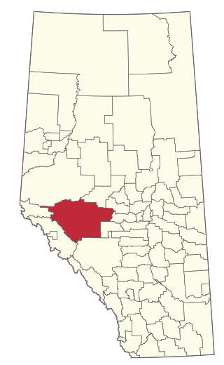
Yellowhead County is a municipal district in west central Alberta, Canada. It is the only municipal district within Alberta census division No. 14.

Clairmont is a hamlet in northern Alberta, Canada within the County of Grande Prairie No. 1. Previously an incorporated municipality, Clairmont dissolved from village status on January 1, 1946 to become part of the Municipal District of Bear Lake No. 740.

Cadotte Lake is an unincorporated community in northern Alberta, Canada within Northern Sunrise County. It is located on the northern shore of the homonymous lake, along Highway 986, 79 km (49 mi) east of Peace River and 68 km (42 mi) west of the Bicentennial Highway.

<span class="mw-page-title-main">Rural Municipality of Reno No. 51</span> Rural municipality in Saskatchewan, Canada

The Rural Municipality of Reno No. 51 is a rural municipality (RM) in the Canadian province of Saskatchewan within Census Division No. 4 and SARM Division No. 3. Located in the southwest corner of the province, it is adjacent to the United States border to the south and the Alberta boundary to the west.

Queenstown is a hamlet in southern Alberta, Canada within Vulcan County. It is located approximately 26 kilometres (16 mi) south of Highway 1 and 92 kilometres (57 mi) southeast of Calgary.

References

  1. 1 2 AltaLIS (November 2, 2006). "Specifications of Settlements" (PDF). Archived from the original (PDF) on July 7, 2011. Retrieved April 25, 2010.
  2. Alberta Boundary Data Archived 2009-05-31 at the Wayback Machine