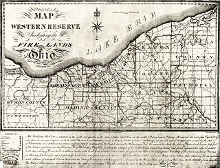
The Public Land Survey System (PLSS) is the surveying method developed and used in the United States to plat, or divide, real property for sale and settling. Also known as the Rectangular Survey System, it was created by the Land Ordinance of 1785 to survey land ceded to the United States by the Treaty of Paris in 1783, following the end of the American Revolution. Beginning with the Seven Ranges in present-day Ohio, the PLSS has been used as the primary survey method in the United States. Following the passage of the Northwest Ordinance in 1787, the Surveyor General of the Northwest Territory platted lands in the Northwest Territory. The Surveyor General was later merged with the United States General Land Office, which later became a part of the U.S. Bureau of Land Management (BLM). Today, the BLM controls the survey, sale, and settling of lands acquired by the United States.
The 49th parallel north is a circle of latitude that is 49° north of Earth's equator. It crosses Europe, Asia, the Pacific Ocean, North America, and the Atlantic Ocean.
The Dominion Land Survey is the method used to divide most of Western Canada into one-square-mile (2.6 km2) sections for agricultural and other purposes. It is based on the layout of the Public Land Survey System used in the United States, but has several differences. The DLS is the dominant survey method in the Prairie provinces, and it is also used in British Columbia along the Railway Belt, and in the Peace River Block in the northeast of the province.

The Land Ordinance of 1785 was adopted by the United States Congress of the Confederation on May 20, 1785. It set up a standardized system whereby settlers could purchase title to farmland in the undeveloped west. Congress at the time did not have the power to raise revenue by direct taxation, so land sales provided an important revenue stream. The Ordinance set up a survey system that eventually covered over three-quarters of the area of the continental United States.

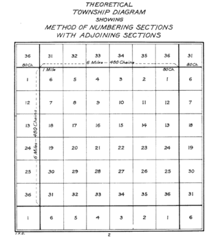
A survey township, sometimes called a Congressional township or just township, as used by the United States Public Land Survey System and by Canada's Dominion Land Survey is a nominally-square area of land that is nominally six survey miles on a side. Each 36-square-mile township is divided into 36 sections of one square mile each. The sections can be further subdivided for sale.

The Willamette Stone was a small stone obelisk originally installed by the Department of Interior in 1885 in the western hills of Portland, Oregon in the United States to mark the intersection and origin of the Willamette meridian and Willamette baseline. It replaced a cedar stake placed by the Surveyor General of the Oregon Territory in 1851; this stake defined the grid system of sections and townships from which all real property in the states of Oregon and Washington has been measured following the Donation Land Claim Act of 1850. The Willamette meridian runs north–south, and the Willamette baseline runs east–west through the marker. The easternmost northeast corner of Washington County is sited on the marker.

In U.S. land surveying under the Public Land Survey System (PLSS), a section is an area nominally one square mile, containing 640 acres, with 36 sections making up one survey township on a rectangular grid.

In surveying, a baseline is generally a line between two points on the earth's surface and the direction and distance between them. In a triangulation network, at least one baseline between two stations needs to be measured to calculate the size of the triangles by trigonometry.
A range road in Canada is a road that runs north–south along a range grid line of the Dominion Land Survey. Range roads are perpendicular to township roads which run east–west along the township grid lines.

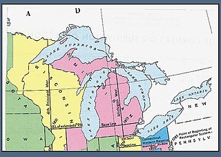
The Michigan meridian is the principal meridian used as a reference in the Michigan Survey, the survey of the U.S. state of Michigan in the early 19th century. It is located at 84 degrees, 21 minutes and 53 seconds west longitude at its northern terminus at Sault Ste. Marie, and varies very little from that line down the length of the state.

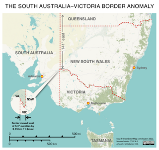
The border between the Australian states of South Australia and Victoria was established in 1836 by imperial letters patent "as the 141st degree meridian of longitude east of Greenwich". In 1836 the land in what is now called Victoria was part of the colony of New South Wales, the original Victorian border was drawn between the colonies of South Australia and New South Wales. An error came about in establishing the position of the 141st meridian, and more than 75 years and a protracted legal dispute passed before the precise placement of the border was settled, resulting in the forfeiture of more than 1,300 km2 (500 sq mi) of territory from South Australia to Victoria.

Surveyor Generals Corner is a remote point where the Australian state boundaries of South Australia, Western Australia and the Northern Territory meet.

Saskatchewan, the middle of Canada's three prairie provinces, has an area of 588,276.09 square kilometres (227,134.67 sq mi) and population of 1,150,632, mostly living in the southern half of the province.

South and East of the First Principal Meridian is a land description in the American Midwest.

The Tallahassee meridian, in longitude 84° 16′ 37.59″ west from the prime meridian at Greenwich, runs north and south from the initial point on the base line at Tallahassee, in latitude 30° 26′ 04.12″ north, and as a principal meridian governs the surveys in Florida and Alabama as part of the Public Land Survey System.

The New Mexico meridian, is longitude 106° 53′ 40″ west from Greenwich. It extends throughout New Mexico and into Colorado, and together with the baseline, at latitude 34° 15′ 25″ north, governs township and range surveys in New Mexico, except those in the northwest corner of the state which refer to the Navajo meridian and baseline. The New Mexico meridian and Baseline also provide the basis for township and range surveys in the upper valley of the Rio Grande del Norte in Colorado.

The Indian meridian, in longitude 97° 14′ 30″ west from Greenwich, extends from Red River to the south boundary of Kansas, and, with the base line in latitude 34° 30′ north, governs the surveys in Oklahoma east of 100° west longitude from Greenwich.

Star Gazers' Stone located on Star Gazers' Farm near Embreeville, Pennsylvania, USA, marks the site of a temporary observatory established in January 1764 by Charles Mason and Jeremiah Dixon which they used in their survey of the Mason-Dixon line. The stone was placed by Mason and Dixon about 700 feet (213 m) north of the Harlan House, which was used as a base of operations by Mason and Dixon through the four-and-a-half-year-long survey. Selected to be about 31 miles (50 km) west of the then southernmost point in Philadelphia, the observatory was used to determine the precise latitude of its location. The latitude of the Maryland-Pennsylvania border was then set to be 15 miles (24.1 km) south of the point in Philadelphia. The farm, including the house and stone, were listed on the National Register of Historic Places on May 9, 1985. In 2013 construction was completed on a parking area to allow public access to Star Gazers Stone.

North and East of the First Principal Meridian is a survey and land description in the northwest part of the U.S. state of Ohio.

Queensland is the north-eastern state of Australia and has land borders with three other Australian states and territories: New South Wales, South Australia and Northern Territory. To the north of Queensland is the Torres Strait separating the Australian mainland from Papua New Guinea. To the east of Queensland is the Coral Sea, part of the Pacific Ocean. There are many islands off the Queensland coast which form part of the state of Queensland.


