Improvement District No. 24

Last updated

Improvement District No. 24
Improvement District No. 24 (Wood Buffalo)
AB locator ID NO 24 (WOOD BUFFALO).svg
Location within Alberta
Coordinates: 59°2′N113°19′W / 59.033°N 113.317°W / 59.033; -113.317 Coordinates: 59°2′N113°19′W / 59.033°N 113.317°W / 59.033; -113.317
CountryCanada
Province Alberta
Region Northern Alberta
Census division No. 16
Established [1] January 1, 1967
Renumbered [1] January 1, 1969
Government
  Governing body Alberta Municipal Affairs (AMA)
  Minister of AMA Ric McIver
  CAOTroy Shewchuk
   MLA Dan Williams and Tany Yao
Area
 (2021) [3]
  Land33,053.78 km2 (12,762.14 sq mi)
Population
 (2021) [3]
  Total706
  Density0/km2 (0/sq mi)
Time zone UTC−7 (MST)
  Summer (DST) UTC−6 (MDT)

Improvement District No. 24, or Improvement District No. 24 (Wood Buffalo), [4] is an improvement district in Alberta, Canada. Coextensive with the portion of Wood Buffalo National Park in northeast Alberta, the improvement district provides local governance for lands within the park that are not within Indian reserves.

Contents

History

Improvement District (ID) No. 24 was originally formed as ID No. 150 on January 1, 1967. [1] ID No. 150 was renumbered to ID No. 24 on January 1, 1969. [1]

Geography

Improvement District (ID) No. 24 is adjacent to the northern boundary of the province of Alberta. [5] It borders the Northwest Territories to the north, the Regional Municipality of Wood Buffalo to the east and south, and Mackenzie County to the west. [5] The Peace River meanders eastward through ID No. 24, which at its confluence with Riviere des Rochers becomes the Slave River. [5] The Athabasca River, Riviere des Rochers, and the Slave River comprise much of the eastern boundary of ID No. 24. [5] Some of its water bodies include Baril Lake, Lake Claire, and Mamawi Lake. [5] The majority of the Peace-Athabasca Delta is within the southeast portion of ID No. 24. [5]

Communities and localities

No urban municipalities, hamlets, or urban service areas are within ID No. 24. [1] A portion of the St. Bruno Farm settlement is within the northeast portion of the improvement district. [5]

Demographics

In the 2021 Census of Population conducted by Statistics Canada, Improvement District No. 24 had a population of 706 living in 113 of its 133 total private dwellings, a change of

In the 2016 Census of Population conducted by Statistics Canada, Improvement District No. 24 had a population of 648 living in 106 of its 123 total private dwellings, a change of

Attractions

Alberta's portion of Wood Buffalo National Park is within Improvement District No. 24. [5]

Government

Improvement District No. 24 is governed by Alberta's Minister of Municipal Affairs. [1]

See also

Related Research Articles

<span class="mw-page-title-main">Fort McMurray</span> Place in Alberta, Canada

Fort McMurray is an urban service area in the Regional Municipality of Wood Buffalo in Alberta, Canada. It is located in northeast Alberta, in the middle of the Athabasca oil sands, surrounded by boreal forest. It has played a significant role in the development of the national petroleum industry. The 2016 Fort McMurray wildfire led to the evacuation of its residents and caused widespread damage.

<span class="mw-page-title-main">Fort Chipewyan</span> Hamlet in Alberta, Canada

Fort Chipewyan, commonly referred to as Fort Chip, is a hamlet in northern Alberta, Canada, within the Regional Municipality (RM) of Wood Buffalo. It is located on the western tip of Lake Athabasca, adjacent to Wood Buffalo National Park, approximately 223 kilometres (139 mi) north of Fort McMurray.

<span class="mw-page-title-main">Jasper, Alberta</span> Specialized municipality in Alberta, Canada

Jasper is a specialized municipality and townsite in western Alberta within the Canadian Rockies. The townsite is in the Athabasca River valley and is the commercial centre of Jasper National Park.

<span class="mw-page-title-main">Regional Municipality of Wood Buffalo</span> Municipality in Alberta, Canada

The Regional Municipality of Wood Buffalo is a specialized municipality in northeast Alberta, Canada. It is the second largest municipality in Alberta by area and is home to oil sand deposits known as the Athabasca oil sands.

<span class="mw-page-title-main">Crowsnest Pass, Alberta</span> Specialized municipality in Alberta, Canada

The Municipality of Crowsnest Pass is a specialized municipality in southwest Alberta, Canada. Within the Rocky Mountains adjacent to the eponymous Crowsnest Pass, the municipality formed as a result of the 1979 amalgamation of five municipalities – the Village of Bellevue, the Town of Blairmore, the Town of Coleman, the Village of Frank, and Improvement District No. 5, which included the Hamlet of Hillcrest and numerous other unincorporated communities.

<span class="mw-page-title-main">Division No. 16, Alberta</span> Census division in Alberta, Canada

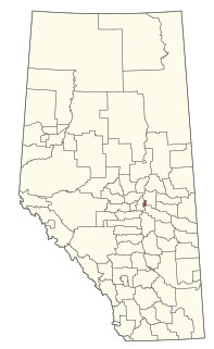
Division No. 16 is a census division in Alberta, Canada. It is located in the northeast portion of northern Alberta and surrounds the Urban Service Area of Fort McMurray.

<span class="mw-page-title-main">Lac La Biche County</span> Specialized municipality in Alberta, Canada

Lac La Biche County is a specialized municipality within Division No. 12 in northern Alberta, Canada. It was established through the amalgamation of the Town of Lac La Biche and Lakeland County in 2007.

<span class="mw-page-title-main">Mackenzie County</span> Specialized municipality in Alberta, Canada

Mackenzie County is a specialized municipality in northern Alberta, Canada. It is located in Census Division 17, along the Mackenzie Highway. Mackenzie County municipal office is located in the Hamlet of Fort Vermilion.

<span class="mw-page-title-main">Special Area No. 2</span> Special area in Alberta, Canada

Special Area No. 2 is a special area in southern Alberta, Canada. It is a rural municipality similar to a municipal district; however, the elected council is overseen by four representatives appointed by the province, the Special Areas Board.

<span class="mw-page-title-main">Fort McKay</span> Indian settlement and hamlet in Alberta, Canada

Fort McKay or Fort MacKay is a community in northeast Alberta, Canada that is located at the confluence of the Athabasca and MacKay rivers. It is approximately 54 km (34 mi) north of Fort McMurray via Highway 63 and Fort McKay Road. The community has an elevation of 260 m (850 ft).

Anzac is a hamlet in northern Alberta, Canada within the Regional Municipality (RM) of Wood Buffalo. It is located on Highway 881 along the east shore of Gregoire Lake, approximately 36 kilometres (22 mi) southeast of Fort McMurray.

Conklin is a hamlet in northern Alberta, Canada within the Regional Municipality (RM) of Wood Buffalo. It is located on Highway 881 between Fort McMurray and Lac La Biche. It lies near the west end of Christina Lake at an elevation of 575 metres (1,886 ft), and was named for John Conklin, a railroad employee.

Colinton is a hamlet in northern Alberta, Canada within Athabasca County. It is located 4 kilometres (2.5 mi) east of Highway 2 on Highway 663, approximately 121 kilometres (75 mi) north of Edmonton.

Gregoire Lake Estates is a hamlet in northern Alberta, Canada within the Regional Municipality (RM) of Wood Buffalo. It is located on Highway 881, approximately 30 kilometres (19 mi) southeast of Fort McMurray.

Janvier South is a hamlet in northern Alberta, Canada within the Regional Municipality (RM) of Wood Buffalo. Whle the hamlet's official name is Janvier South according to Alberta Municipal Affairs, it is also known and referred to as Janvier by the RM of Wood Buffalo and its residents. It is further alternately known as Chard. The latter name is after A. Chard, a transportation official.

<span class="mw-page-title-main">Improvement District No. 349</span> Former improvement district in Alberta, Canada

Improvement District No. 349 was an improvement district in northeast Alberta, Canada that existed between January 1, 2012 and May 1, 2021. The improvement district was largely coextensive with the Alberta portion of the Cold Lake Air Weapons Range. On May 1, 2021, the improvement district was annexed by the adjacent Municipal District (MD) of Bonnyville No. 87.

<span class="mw-page-title-main">Improvement District No. 13</span> Improvement district in Alberta, Canada

Improvement District No. 13, or Improvement District No. 13 , is an improvement district in Alberta, Canada. Coextensive with Elk Island National Park in central Alberta, the improvement district provides local governance for lands within the park.

<span class="mw-page-title-main">Improvement District No. 4</span> Improvement district in Alberta, Canada

Improvement District No. 4, or Improvement District No. 04 (Waterton), is an improvement district in Alberta, Canada. Coextensive with Waterton Lakes National Park in southern Alberta, the improvement district provides local governance for lands within the park that are not within an Indian reserve.

<span class="mw-page-title-main">Improvement District No. 25</span> Improvement district in Alberta, Canada

Improvement District No. 25, or Improvement District No. 25 , is an improvement district in Alberta, Canada. Coextensive with Willmore Wilderness Park in central Alberta, the improvement district provides local governance for lands within the park.

References

  1. 1 2 3 4 5 6 7 "Municipal Profiles: Improvement Districts" (PDF). Alberta Municipal Affairs. October 1, 2021. pp. 29–35. Retrieved October 3, 2021.
  2. "Alberta Municipal Affairs". Alberta Municipal Affairs . Retrieved May 25, 2015.
  3. 1 2 3 "Population and dwelling counts: Canada, provinces and territories, and census subdivisions (municipalities)". Statistics Canada. February 9, 2022. Retrieved February 9, 2022.
  4. "2022 Municipal Codes" (PDF). Alberta Municipal Affairs. January 5, 2022. Retrieved January 21, 2022.
  5. 1 2 3 4 5 6 7 8 9 2021 Provincial Base Map: Municipalities (PDF) (Map). Alberta Environment and Parks. July 26, 2021. Retrieved October 3, 2021.
  6. "Economic Regions - SGC 2006 (4816051 - Improvement District No. 24)". Statistics Canada. November 27, 2018. Retrieved October 2, 2021.
  7. Geo-Administrative Areas (Hamlet, Locality and Townsite Culture Points) (Geodatabase layer) (Map). AltaLIS. October 26, 2020. Retrieved October 2, 2021.{{cite map}}: CS1 maint: date and year (link)
  8. "Population and dwelling counts, for Canada, provinces and territories, and census subdivisions (municipalities), 2016 and 2011 censuses – 100% data (Alberta)". Statistics Canada. February 8, 2017. Retrieved February 8, 2017.