
Fort McMurray is an urban service area in the Regional Municipality of Wood Buffalo in Alberta, Canada. It is located in northeast Alberta, in the middle of the Athabasca oil sands, surrounded by boreal forest. It has played a significant role in the development of the national petroleum industry. The 2016 Fort McMurray wildfire led to the evacuation of its residents and caused widespread damage.

Fort Chipewyan, commonly referred to as Fort Chip, is a hamlet in northern Alberta, Canada, within the Regional Municipality (RM) of Wood Buffalo. It is located on the western tip of Lake Athabasca, adjacent to Wood Buffalo National Park, approximately 223 kilometres (139 mi) north of Fort McMurray.
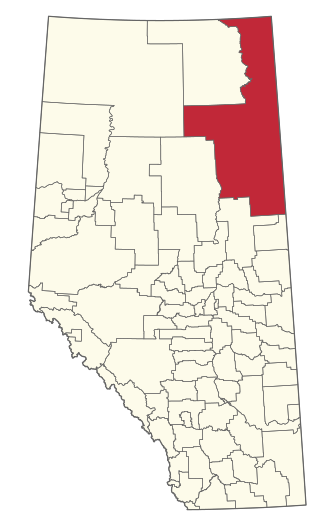
The Regional Municipality of Wood Buffalo is a specialized municipality in northeast Alberta, Canada. It is the largest municipality in North America by area and is home to oil sand deposits known as the Athabasca oil sands.

Fort Smith is a town in the South Slave Region of the Northwest Territories (NWT), Canada. It is located in the southeastern portion of the Northwest Territories, on the Slave River and adjacent to the Alberta border along the 60th parallel north.

Fort Resolution is a hamlet in the South Slave Region of the Northwest Territories, Canada. The community is situated at the mouth of the Slave River, on the shores of Great Slave Lake, and at the end of the Fort Resolution Highway. It is the headquarters of the Deninu Kųę́ First Nation, whose Chief is Louis Balsillie.

Division No. 17 is a census division in Alberta, Canada. It spans the central and northwest portions of northern Alberta and its largest urban community is the Town of Slave Lake. Division No. 17 is the largest census division in Alberta according to area and also has the lowest population density.

Mackenzie County is a specialized municipality in northern Alberta, Canada. It is located in Census Division 17, along the Mackenzie Highway. The municipal office is located in the hamlet of Fort Vermilion.
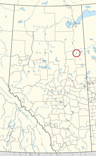
Chipewyan Lake is an unincorporated community in northern Alberta within the Municipal District of Opportunity No. 17. It is located on the southern shore of Chipewyan Lake approximately 110 kilometres (68 mi) north of Wabasca and 128 kilometres (80 mi) west of Fort McMurray. The community is not accessible by Alberta's provincial highway system. It is however accessible by using the Laricina Energy/Shell Canada S-4 access road.

Fort McKay or Fort MacKay is a community in northeast Alberta, Canada that is located at the confluence of the Athabasca and MacKay rivers. It is approximately 54 km (34 mi) north of Fort McMurray via Highway 63 and Fort McKay Road. The community has an elevation of 260 m (850 ft).
Anzac is a hamlet in northern Alberta, Canada within the Regional Municipality (RM) of Wood Buffalo. It is located on Highway 881 along the east shore of Gregoire Lake, approximately 36 kilometres (22 mi) southeast of Fort McMurray.

Red Earth Creek is a hamlet in Alberta, Canada within the Municipal District of Opportunity No. 17. It is located east of Highway 88, between the Town of Slave Lake and the Hamlet of Fort Vermilion, and has an elevation of 520 metres (1,710 ft).
Sandy Lake, also known as Pelican Mountain, is a hamlet in Alberta, Canada within the Municipal District of Opportunity No. 17. It is located on Highway 813, between Calling Lake and Wabasca. It has an elevation of 565 metres (1,854 ft).
Conklin is a hamlet in northern Alberta, Canada within the Regional Municipality (RM) of Wood Buffalo. It is located on Highway 881 between Fort McMurray and Lac La Biche. It lies near the west end of Christina Lake at an elevation of 575 metres (1,886 ft), and was named for John Conklin, a railroad employee.
Gregoire Lake Estates is a hamlet in northern Alberta, Canada within the Regional Municipality (RM) of Wood Buffalo. It is located on Highway 881, approximately 30 kilometres (19 mi) southeast of Fort McMurray.
Saprae Creek is a hamlet in northern Alberta, Canada within the Regional Municipality (RM) of Wood Buffalo. It is located 3 kilometres (1.9 mi) north of Highway 69, approximately 11 kilometres (6.8 mi) east of Fort McMurray.
Gregoire Lake 176 is an Indian reserve of the Fort McMurray First Nation in Alberta, located within the Regional Municipality of Wood Buffalo. It is 35 kilometres southeast of Fort McMurray. In the 2016 Canadian Census, it recorded a population of 191 living in 62 of its 74 total private dwellings.

Improvement District No. 24, or Improvement District No. 24 , is an improvement district in Alberta, Canada. Coextensive with the portion of Wood Buffalo National Park in northeast Alberta, the improvement district provides local governance for lands within the park that are not within Indian reserves.

Gregoire Lake 176A is an Indian reserve of the Fort McMurray First Nation in Alberta, located within the Regional Municipality of Wood Buffalo. In the 2016 Canadian Census, it recorded a population of 130 living in 43 of its 49 total private dwellings.
