
Medicine Hat is a city in southeast Alberta, Canada. It is located along the South Saskatchewan River. It is approximately 169 km (105 mi) east of Lethbridge and 295 km (183 mi) southeast of Calgary. This city and the adjacent Town of Redcliff to the northwest are within Cypress County. Medicine Hat was the sixth-largest city in Alberta in 2016 with a population of 63,230. It is also the sunniest place in Canada according to Environment and Climate Change Canada, averaging 2,544 hours of sunshine a year.

Division No. 6 is a census division in Alberta, Canada. It includes the City of Calgary and surrounding areas. The majority of the division consists of Alberta's Calgary Region, while the northern portion of the division includes parts of central Alberta. The division also forms the southern segment of the Calgary–Edmonton Corridor. Division No. 6 is the largest census division in Alberta according to population and also has the highest population density.

Seven Persons is a hamlet in Alberta, Canada within Cypress County. It is located approximately 20 kilometres (12 mi) southwest of Medicine Hat on Highway 3 and has an elevation of 755 metres (2,477 ft).
Redcliff is a town in southern Alberta, Canada. Adjacent to the City of Medicine Hat to the east and Cypress County to the west and north, the town is bisected by Highway 1 and is located on the north bank of the South Saskatchewan River.

Athabasca County is a municipal district in north central Alberta, Canada. It is located northeast of Edmonton and is in Census Division No. 13. Prior to an official renaming on December 1, 2009, Athabasca County was officially known as the County of Athabasca No. 12.
Division No. 10 is a census division in Alberta, Canada. It is located in the east-central portion of central Alberta and includes Alberta's portion of the City of Lloydminster.
Division No. 12 is a census division in Alberta, Canada. Including the City of Cold Lake, the majority of the division is located in the northeast corner of central Alberta. The northern portion of the division is located within northern Alberta.

Bow Island is a town in Alberta, Canada. It is located on Highway 3 in southern Alberta, approximately 100 km (62 mi) north of the United States border, 320 km (200 mi) southeast of Calgary and 51 km (32 mi) southwest of Medicine Hat.
Marwayne is a village in central Alberta, Canada. It is located 44 kilometres (27 mi) northwest of the city of Lloydminster and 21 kilometres (13 mi) west of the Saskatchewan border.
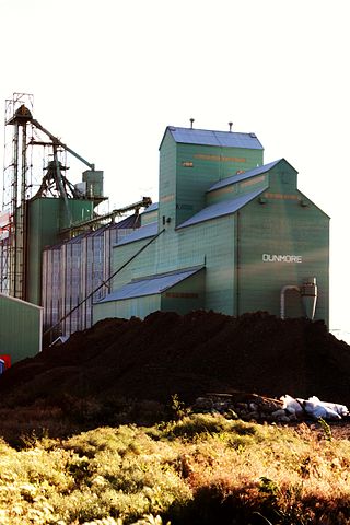
Dunmore is a hamlet in Alberta, Canada, within Cypress County, 2.6 kilometres (1.6 mi) southeast of Medicine Hat's city limits on Highway 1 and the Canadian Pacific Railway mainline. A portion of the hamlet is recognized as a designated place by Statistics Canada.
Schuler is a hamlet in southern Alberta, Canada within Cypress County, located 4 kilometres (2.5 mi) east of Highway 41, approximately 40 kilometres (25 mi) northeast of Medicine Hat.
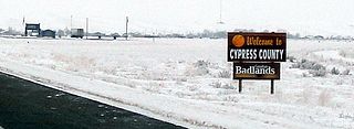
Cypress County is a municipal district in southeastern Alberta, Canada that surrounds the City of Medicine Hat and the Town of Redcliff. The municipality is part of Census Division 1, Alberta. The first farm in the area was settled in 1890.

The County of Forty Mile No. 8 is a municipal district in south eastern Alberta, Canada. It is located in Census Division 1, southwest of Medicine Hat. Its municipal office is located in the Village of Foremost.

Acadia Valley is a hamlet in southeast Alberta, Canada within the Municipal District (MD) of Acadia No. 34. The MD of Acadia No. 34's municipal office is located in Acadia Valley.

Grassy Lake is a hamlet in Alberta, Canada within the Municipal District of Taber. It is located on the Crowsnest Highway (Highway 3), midway between the cities of Lethbridge to the west and Medicine Hat to the east. It is approximately 13 km (8.1 mi) west of Burdett and 34 km (21 mi) east of Taber. It has an elevation of 810 metres (2,660 ft). It was formerly incorporated as a village, dissolving into the Municipal District of Taber on July 1, 1996.
Walsh is a hamlet in Alberta, Canada within Cypress County.
Suffield is a hamlet in southern Alberta, Canada within Cypress County. It is located on the Trans-Canada Highway approximately 32 km (20 mi) northwest of Medicine Hat, and just south of CFB Suffield.
Hilda is a hamlet in southern Alberta, Canada within Cypress County, located 4 kilometres (2.5 mi) east of Highway 41, approximately 67 kilometres (42 mi) northeast of Medicine Hat. In 1910, the post master named the post office "Hilda" after his infant daughter.
Veinerville is a hamlet in southern Alberta, Canada within Cypress County. It is located 0.5 kilometres (0.31 mi) northwest of Highway 41A, and less than 150 metres (490 ft) from Medicine Hat's east boundary.
Desert Blume is a hamlet in southern Alberta, Canada within Cypress County, adjacent to the southern boundary of Medicine Hat.
